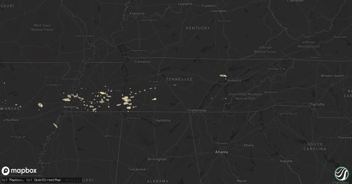
Hail Map in Tennessee on July 8, 2014
Get this storm
July 8 map
$229
one time, instant access
Download today. No call, no setup
Keep the $229
Bought the map and want the full workflow? Apply the entire $229 to a subscription within 7 days. None of it is wasted.
Every map, not just this one
This buys you this map. Subscription and you get every map we run, in the markets you choose from a few cities to whole states to nationwide. Plus real-time alerts the moment a storm fires.
Contact data
Name, contact info, occupancy, even credit band for addresses in the footprint. You go from where it hit to who to call.
Become the source they trust
Unlimited branding weather history reports on demand. You already have the documented answer ready for the property owner, and you are the one who showed up with it.
Property data and RoofTrace estimates
Pull up any address you have got, its value and the exact code rules for that jurisdiction, straight from One Click Code. Then RoofTrace estimates the squares, pitch, and roof value, priced the way you price.
Storm reports in Tennessee
Tennessee
| Date | Description |
|---|---|
| 07/08/20145:50 PM CDT | Hail for 10 minutes on jefferson street in bemis. |
| 07/08/20145:20 PM CDT | 2 trees down in manchester near the intersection of spring street and hwy 41 |
| 07/08/20145:15 PM CDT | Trees down. |
| 07/08/20144:20 PM CDT | A few trees down near wears valley rd just south of pigeon forge tennessee. |
| 07/08/20144:20 PM CDT | Trees down near highway 64 and 2 miles west of 411. |
| 07/08/20144:15 PM CDT | 5 trees down in unicoi tennessee off of unicoi drive. |
| 07/08/20144:15 PM CDT | A few trees down near mountain city. |
| 07/08/20144:05 PM CDT | Reports of trees down and power outages in watauga near elizabethton tennessee. |
| 07/08/20144:00 PM CDT | Trees down county-wide. |
| 07/08/20143:58 PM CDT | Metal roof blown off building in johnson city tennessee. |
| 07/08/20143:53 PM CDT | Trees down near the boones creek area. |
| 07/08/20143:40 PM CDT | A few trees down just east of seymour. |
| 07/08/20142:20 PM CDT | Tree down in halls. |
| 07/08/20142:15 PM CDT | Several trees down on western end of the county. |
| 07/07/20148:15 PM CDT | Tree down on state line road |
| 07/07/20148:10 PM CDT | Wlx radio reports tree limbs down on busby road between loretto and westpoint |
| 07/07/20148:00 PM CDT | Tree down on long branch road |
All States Impacted by Hail Map on July 8, 2014
Cities Impacted by Hail Map on July 8, 2014
- Patagonia, AZ
- Wetmore, CO
- Rye, CO
- Beulah, CO
- Princeton, AL
- Hollytree, AL
- Flagstaff, AZ
- Mount Judea, AR
- Witts Springs, AR
- Sagamore, PA
- Home, PA
- Marion Center, PA
- Shelocta, PA
- Creekside, PA
- Rural Valley, PA
- Maysville, OK
- Wayne, OK
- Holdenville, OK
- Wewoka, OK
- Sasakwa, OK
- Wellton, AZ
- Salida, CO
- Warrington, PA
- Montgomeryville, PA
- Lansdale, PA
- North Wales, PA
- Doylestown, PA
- Chalfont, PA
- Heavener, OK
- Plainview, AR
- Brownsville, TN
- Glenwood, AR
- Olivehill, TN
- Lynnville, TN
- Culleoka, TN
- Cornersville, TN
- Lewisburg, TN
- Ponca, AR
- Lyons, NY
- Skull Valley, AZ
- Whiteville, TN
- Waynesboro, TN
- Bath Springs, TN
- Clifton, TN
- Savannah, TN
- Dundee, MS
- Sledge, MS
- Bismarck, AR
- Buckeye, AZ
- Belleville, AR
- Danville, AR
- Ola, AR
- Parthenon, AR
- Jasper, AR
- Deer, AR
- Harrison, AR
- Marble Falls, AR
- Compton, AR
- Kingston, AR
- Cove, AR
- Oklahoma City, OK
- Pottsville, AR
- Hattieville, AR
- Hector, AR
- Atkins, AR
- Jerusalem, AR
- Scotland, AR
- Russellville, AR
- Cleveland, AR
- Mena, AR
- Harvey, AR
- Yucca, AZ
- Wister, OK
- Oark, AR
- Saint Paul, AR
- Ozark, AR
- Pettigrew, AR
- Cherokee, AL
- Ford City, PA
- Kittanning, PA
- Hazleton, PA
- Briceville, TN
- Oliver Springs, TN
- Clinton, TN
- San Ygnacio, TX
- Ada, OK
- Nogales, AZ
- Cypress Inn, TN
- Ripley, TN
- Clarksville, AR
- Needles, CA
- Crown King, AZ
- Congress, AZ
- Green Valley, AZ
- Lafayette, LA
- Kingman, AZ
- Pitman, PA
- Klingerstown, PA
- San Ysidro, NM
- Holland Patent, NY
- Rome, NY
- Remsen, NY
- Jackson, TN
- Denmark, TN
- Medon, TN
- Somerville, TN
- Topock, AZ
- Henderson, TN
- Bethel Springs, TN
- Finger, TN
- Drummonds, TN
- Monticello, NM
- Young, AZ
- Socorro, NM
- Maud, OK
- Germantown, TN
- Sells, AZ
- Oak Hall, VA
- New Church, VA
- Quartzsite, AZ
- Vendor, AR
- Greenup, KY
- Flatwoods, KY
- Ashland, KY
- Russell, KY
- Ironton, OH
- South Point, OH
- Selmer, TN
- Ramer, TN
- Pueblo, CO
- Woodland Park, CO
- Seligman, AZ
- Shady Point, OK
- Lutts, TN
- Collinwood, TN
- Questa, NM
- Prescott, AZ
- Deming, NM
- Westcliffe, CO
- Marietta, OH
- London, AR
- Pelsor, AR
- Lindrith, NM
- Vidal, CA
- Iron City, TN
- Grand Junction, TN
- Hickory Valley, TN
- Saulsbury, TN
- Kirkland, AZ
- Nipton, CA
- Searchlight, NV
- Zachary, LA
- Linden, TN
- Mohave Valley, AZ
- Konawa, OK
- Krotz Springs, LA
- Jemez Pueblo, NM
- Las Cruces, NM
- Conchas Dam, NM
- Saint Martinville, LA
- Jefferson, CO
- Como, CO
- Mansfield, AR
- Waldron, AR
- Mule Creek, NM
- Ajo, AZ
- Witter, AR
- Jean, NV
- Crowley, LA
- Baton Rouge, LA
- Western Grove, AR
- Combs, AR
- Green Forest, AR
- Hasty, AR
- Winslow, AR
- Huntsville, AR
- Elkins, AR
- Ona, WV
- Huntington, WV
- Chesapeake, OH
- Proctorville, OH
- Barboursville, WV
- Lesage, WV
- Murphy, NC
- Bolivar, TN
- Lexington, TN
- Bagdad, AZ
- Lake Havasu City, AZ
- Syracuse, NY
- Skaneateles, NY
- Marietta, NY
- Auburn, NY
- Marcellus, NY
- West Helena, AR
- Helena, AR
- Lexa, AR
- Smithville, OK
- Jennings, LA
- Glenwood, NM
- Buckhorn, NM
- McCrory, AR
- Santa Fe, NM
- Durhamville, NY
- Verona, NY
- Mountainburg, AR
- Hohenwald, TN
- Dardanelle, AR
- Arlington, OH
- Williamstown, OH
- Forest, OH
- Dunkirk, OH
- Tucson, AZ
- Roma, TX
- Parker, AZ
- Earp, CA
- Briggsville, AR
- Gravelly, AR
- Bluffton, AR
- Marks, MS
- Sonoita, AZ
- Oden, AR
- Lindsay, OK
- Courtland, AL
- Dateland, AZ
- Indiantown, FL
- Booneville, AR
- Mercer, TN
- Houston, TX
- Hornsby, TN
- Toone, TN
- Mount Vernon, AR
- Romance, AR
- Barneveld, NY
- Prospect, NY
- Stittville, NY
- Killen, AL
- Westpoint, TN
- Hartman, AR
- Yarnell, AZ
- Burlison, TN
- Blossvale, NY
- Stratford, OK
- Newark, NY
- Herndon, PA
- Dornsife, PA
- Sacramento, PA
- Hegins, PA
- Payson, AZ
- Sedona, AZ
- Centerville, TN
- Ada, OH
- Dola, OH
- Abbeville, LA
- Iota, LA
- Basile, LA
- Atoka, TN
- Brighton, TN
- Kirkville, NY
- Chittenango, NY
- Hooker, OK
- Howard, CO
- Oak Ridge, TN
- Boles, AR
- Parks, AR
- Kentwood, LA
- Mason, TN
- Salome, AZ
- Bouse, AZ
- Zapata, TX
- Hampshire, TN
- Williamsport, TN
- Mount Pleasant, TN
- Knoxville, AR
- Lamar, AR
- Addis, LA
- Litchfield, OH
- Dalmatia, PA
- Elizabethville, PA
- Lykens, PA
- Pillow, PA
- Arlington, TN
- Florence, AL
- Howe, OK
- Hodgen, OK
- Woodbury, TN
- Michigan City, MS
- Walnut, MS
- Jemez Springs, NM
- Tucumcari, NM
- Divide, CO
- Woodward, OK
- Quinton, OK
- Breaux Bridge, LA
- Red Oak, OK
- Roll, AZ
- Tellico Plains, TN
- Medina, TN
- Reno, OH
- Vandergrift, PA
- Glen Campbell, PA
- Rochester Mills, PA
- Dayton, PA
- New Kensington, PA
- Freeport, PA
- Elderton, PA
- Natrona Heights, PA
- Gipsy, PA
- Leechburg, PA
- Williston, TN
- Oakland, TN
- Leslie, AR
- Jamesville, NY
- East Syracuse, NY
- Clyde, NY
- Sodus, NY
- North Rose, NY
- Dover, AR
- Peridot, AZ
- Beebe, AR
- Moscow, TN
- Courtland, MS
- Batesville, MS
- Greensburg, LA
- Marcy, NY
- Oriskany, NY
- Darden, TN
- Arlington, AZ
- Pinson, TN
- Erath, LA
- Verona Beach, NY
- Cold Brook, NY
- Canastota, NY
- Hot Springs National Park, AR
- Springfield, AR
- Cotton Plant, AR
- Coahoma, MS
- Decaturville, TN
- Saltillo, MS
- Eloy, AZ
- Loysville, PA
- Blain, PA
- Minoa, NY
- Broussard, LA
- Youngsville, LA
- Casa Grande, AZ
- Waynesfield, OH
- Harrod, OH
- Lobelville, TN
- Damascus, AR
- Grannis, AR
- Starks, LA
- Turrell, AR
- Silver City, NM
- Rogersville, AL
- Wolcott, NY
- Plaquemine, LA
- Stockton, NY
- Dewittville, NY
- Golden Valley, AZ
- Middleton, TN
- Huron, TN
- Rossville, TN
- Sims, AR
- Story, AR
- Mount Ida, AR
- Bonnerdale, AR
- Munford, TN
- Gilmore, AR
- Earle, AR
- Beech Bluff, TN
- Coal Hill, AR
- Readyville, TN
- Columbia, TN
- Arkadelphia, AR
- Spring Hill, TN
- Town Creek, AL
- Riceville, TN
- Allen, OK
- Atwood, OK
- Muldrow, OK
- Lepanto, AR
- Waterloo, AL
- Joiner, AR
- Frenchmans Bayou, AR
- Arnaudville, LA
- Greenbrier, AR
- Houston, AR
- Palm Bay, FL
- Melbourne, FL
- Gila Bend, AZ
- Camillus, NY


