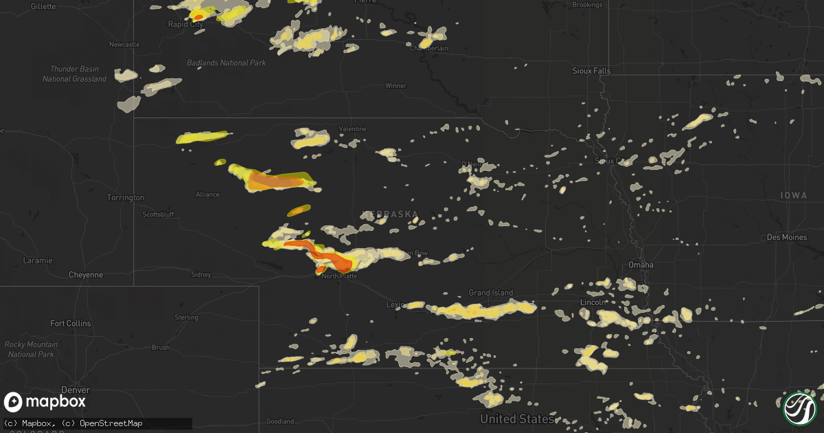
Hail Map in Nebraska on July 6, 2016
Get this storm
July 6 map
$229
one time, instant access
Download today. No call, no setup
Keep the $229
Bought the map and want the full workflow? Apply the entire $229 to a subscription within 7 days. None of it is wasted.
Every map, not just this one
This buys you this map. Subscription and you get every map we run, in the markets you choose from a few cities to whole states to nationwide. Plus real-time alerts the moment a storm fires.
Contact data
Name, contact info, occupancy, even credit band for addresses in the footprint. You go from where it hit to who to call.
Become the source they trust
Unlimited branding weather history reports on demand. You already have the documented answer ready for the property owner, and you are the one who showed up with it.
Property data and RoofTrace estimates
Pull up any address you have got, its value and the exact code rules for that jurisdiction, straight from One Click Code. Then RoofTrace estimates the squares, pitch, and roof value, priced the way you price.
Storm reports in Nebraska
Nebraska
| Date | Description |
|---|---|
| 07/06/20166:58 PM CDT | A local report indicates 58 MPH wind near 1 SSE VALENTINE |
| 07/06/20166:28 PM CDT | Thunderstorm winds estimated at 70 mph took off a shop door and moved a barn wall. A large 18 inch diameter tree branch and numerous small branches were also downed by |
| 07/06/20166:27 PM CDT | A local report indicates 60 MPH wind near 7 E MERRITT RESERVOIR D |
| 07/06/20166:20 PM CDT | Multiple vortex tornado...shortly before becoming rain wrapped. |
| 07/06/20165:56 PM CDT | Reports of a large tornado currently on the ground across southeastern sheridan county. |
| 07/06/20165:45 PM CDT | Collapsing thunderstorm |
| 07/06/20165:06 PM CDT | A local report indicates 1.00 inch wind near 10 SW ARTHUR |
| 07/06/20164:42 PM CDT | A local report indicates 1.00 inch wind near 22 N LAKESIDE |
| 07/06/20164:42 PM CDT | A local report indicates 1.00 inch wind near 5 SW ARTHUR |
| 07/06/20164:35 PM CDT | A local report indicates 1.25 inch wind near 8 W ARTHUR |
| 07/06/20164:25 PM CDT | A local report indicates 1.00 inch wind near 15 S HAY SPRINGS |
| 07/06/20164:18 PM CDT | Tornado lifted at 1619 lt. |
| 07/06/20164:15 PM CDT | A local report indicates a tornado near 6 SSE SAND CANYON |
| 07/06/20164:05 PM CDT | Dust plume observed halfway to cloud base. |
| 07/06/201611:55 AM CDT | A local report indicates 60 MPH wind near COLUMBUS |
| 07/06/20163:13 AM CDT | 59 knot gust at the falls city airport asos. |
| 07/06/20163:04 AM CDT | Large maple tree fell onto a house allowing rain to enter into the home. |
| 07/06/20163:04 AM CDT | Large tree branches down and fence damage. Report submitted via social media. Report time based on radar. |
| 07/06/20162:50 AM CDT | 6 inch diameter limbs blown down. |
| 07/06/20162:10 AM CDT | Six-inch tree limb down on 192nd and i street. Report time based on radar. |
| 07/06/20161:20 AM CDT | This gust occurred behind the squall line in a pres minimum. |
| 07/06/201612:46 AM CDT | From davis station. |
| 07/06/201612:46 AM CDT | From nws hastings davis station. |
| 07/06/201612:37 AM CDT | Also had penny size hail. Corrected original report to better specify nws office location |
| 07/06/201612:37 AM CDT | At least a half dozen reports of large branches down across hastings along with reports of power outages |
| 07/06/201612:37 AM CDT | Also had penny size hail |
| 07/06/201612:24 AM CDT | Corrected location and changed to measured gust. |
| 07/06/201612:24 AM CDT | A local report indicates 62 MPH wind near 5 NW RED CLOUD |
| 07/06/201612:02 AM CDT | A local report indicates 1.00 inch wind near 8 N FRANKLIN |
| 07/05/201611:55 PM CDT | A local report indicates 60 MPH wind near COLUMBUS |
| 07/05/201611:15 PM CDT | Spotter report relayed to emergency manager. Winds estimated at up to 60 mph briefly with initial gusts. Then winds 40 to 50 mph lasted another 10 to 15 minutes.this wa |
| 07/05/201611:00 PM CDT | Trees snapped or uprooted at a residence and the golf course. Power pole snapped at fairgrounds. Power out for 45 minutes in albion. |
| 07/05/201610:52 PM CDT | Large tree down and several branches down in various spots across town. Some of the largest branches svrl inches in diameter. Winds est 55-60 mph. Time est fm radar. |
| 07/05/201610:52 PM CDT | Vague description of branches down all over town. Given dmg in nearby greeley...it is presumed svr or near-svr winds occurred. Time est fm radar. |
| 07/05/201610:30 PM CDT | A local report indicates 1.75 inch wind near 15 NE NORTH PLATTE |
| 07/05/201610:30 PM CDT | A local report indicates 1.75 inch wind near 15 N NORTH PLATTE |
| 07/05/201610:22 PM CDT | Respected storm chaser reporting 60-70 mph winds and branches down |
| 07/05/20169:58 PM CDT | Measured at mccook airport |
| 07/05/20169:50 PM CDT | Delayed report. Time estimated on radar. |
| 07/05/20169:45 PM CDT | Delayed report. Time estimated off of radar. |
| 07/05/20169:40 PM CDT | A local report indicates 60 MPH wind near BROKEN BOW |
| 07/05/20169:40 PM CDT | Delayed report. Time estimated off of radar. Resident stated that there was one strong gust of wind...but after that no hail or rain. |
| 07/05/20169:28 PM CDT | Public estimated location. |
| 07/05/20169:15 PM CDT | A local report indicates 78 MPH wind near 3 N NORTH PLATTE |
| 07/05/20169:15 PM CDT | Via social media |
| 07/05/20169:14 PM CDT | A local report indicates 69 MPH wind near 4 NNE NORTH PLATTE |
| 07/05/20169:12 PM CDT | 70 mph winds. |
| 07/05/20169:05 PM CDT | A local report indicates 58 MPH wind near 7 NNW STRATTON NE |
| 07/05/20169:05 PM CDT | A local report indicates 72 MPH wind near 5 N NORTH PLATTE |
| 07/05/20168:45 PM CDT | A local report indicates 60 MPH wind near SUTHERLAND |
| 07/05/20168:45 PM CDT | A local report indicates 1.75 inch wind near 11 NNE HERSHEY |
| 07/05/20168:45 PM CDT | A local report indicates 1.00 inch wind near 2 N NORTH PLATTE |
| 07/05/20168:40 PM CDT | Delayed report from wednesday...july 6th 2016...relayed via social media. Large pine tree at the national cemetery west of spencer snapped in half...approximately 10 to |
| 07/05/20168:15 PM CDT | Hail inch hail with the wind. |
| 07/05/20168:11 PM CDT | A local report indicates 60 MPH wind near 12 N STUART |
| 07/05/20168:08 PM CDT | A local report indicates a tornado near 15 SW TRYON |
| 07/05/20168:00 PM CDT | Center pivot with 8 towers flipped. Two bolts sheared on west side of base. Pivot base cracked. Time estimated. Delayed report. |
| 07/05/20168:00 PM CDT | A local report indicates 1.75 inch wind near 4 NE SUTHERLAND |
| 07/05/20168:00 PM CDT | Thunderstorm winds destroyed a large metal storage shed...some barbed wire fence and damaged a windmill. Three cattle were also injured by flying debris. |
| 07/05/20168:00 PM CDT | Windmill damaged. Time estimated. Delayed report. |
| 07/05/20167:55 PM CDT | Estimated location. |
| 07/05/20167:44 PM CDT | A local report indicates 60 MPH wind near 2 SE SPRINGVIEW |
| 07/05/20167:35 PM CDT | A local report indicates 1.75 inch wind near 7 ESE ARTHUR |
| 07/05/20167:20 PM CDT | A local report indicates 1.25 inch wind near 6 N ARTHUR |
| 07/05/20167:00 PM CDT | A local report indicates 60 MPH wind near 13 SW MULLEN |
All States Impacted by Hail Map on July 6, 2016
Cities Impacted by Hail Map on July 6, 2016
- Cohagen, MT
- Fort Benning, GA
- Tulia, TX
- Sumner, MO
- Woodland, AL
- Cherry Creek, SD
- Merna, NE
- Callaway, NE
- Broken Bow, NE
- Terry, MT
- Midland, SD
- Stratton, NE
- Trenton, NE
- Ithaca, NE
- Waverly, NE
- Ceresco, NE
- Ashland, NE
- Greenwood, NE
- Princeton, KY
- New England, ND
- Columbia, MO
- Boonville, MO
- New Franklin, MO
- Franklin, MO
- Lower Brule, SD
- Newell, SD
- Belle Fourche, SD
- Nisland, SD
- Stapleton, NE
- Buffalo, SD
- North Platte, NE
- Maxwell, NE
- Riverton, IA
- Farragut, IA
- Northboro, IA
- Shenandoah, IA
- Rock Port, MO
- Hamburg, IA
- Macon, MO
- Anabel, MO
- Birchwood, TN
- Orleans, NE
- Oxford, NE
- Waynesboro, MS
- Lerna, IL
- Mattoon, IL
- Worden, MT
- Greenville, MO
- Patterson, MO
- Silva, MO
- Wappapello, MO
- Williamsville, MO
- McGee, MO
- Atlantic, IA
- Union Center, SD
- Enning, SD
- Crown City, OH
- New Cambria, MO
- Ethel, MO
- Marquand, MO
- Patton, MO
- Fort Stockton, TX
- Wooldridge, MO
- Hallsville, MO
- Centralia, MO
- Rocheport, MO
- Blackwater, MO
- Fayette, MO
- Sturgeon, MO
- Fulton, MO
- Norwood, MO
- Drury, MO
- Ainsworth, NE
- Johnstown, NE
- Plattsburg, MO
- Baconton, GA
- Canyon, TX
- Marcus, IA
- Sturgis, SD
- Kadoka, SD
- Lance Creek, WY
- Lusk, WY
- Lincoln, NE
- Denton, NE
- Hallam, NE
- Martell, NE
- Crete, NE
- Silverton, TX
- Hershey, NE
- Spring Hill, TN
- Columbia, TN
- Box Elder, SD
- Chattahoochee, FL
- Grant City, MO
- Redding, IA
- Olsburg, KS
- Tryon, NE
- Kuttawa, KY
- Eddyville, KY
- Bosworth, MO
- Dunning, NE
- Halsey, NE
- Stewartsville, MO
- Easton, MO
- Peel, AR
- Yellville, AR
- Oakland, AR
- Mountain Home, AR
- Remsen, IA
- Kingsley, IA
- Wessington, SD
- Edison, NE
- Stamford, NE
- Jack, AL
- Elba, AL
- Topeka, KS
- Waucoma, IA
- Cresco, IA
- Lawler, IA
- New Hampton, IA
- Elma, IA
- Chadron, NE
- Whitney, NE
- Hay Springs, NE
- Newcastle, WY
- Saint Marys, KS
- Emmett, KS
- Arthur, NE
- Lemoyne, NE
- Sutherland, NE
- Smith Center, KS
- Lebanon, KS
- Ellsworth, NE
- Virginia, NE
- Liberty, NE
- Burchard, NE
- Fort Thompson, SD
- Beaver City, NE
- Drakesville, IA
- Lebanon, TN
- Alma, NE
- Buchanan, TN
- New Concord, KY
- Andrews, TX
- McCool Junction, NE
- Wessington Springs, SD
- Quanah, TX
- Paducah, TX
- Glendive, MT
- Wibaux, MT
- Tahoka, TX
- Wolfforth, TX
- Ropesville, TX
- Campbell, MO
- Salisbury, MO
- Brookfield, MO
- Rothville, MO
- Mendon, MO
- Marceline, MO
- Bucklin, MO
- Ewing, NE
- Red Cloud, NE
- Guide Rock, NE
- Blanchester, OH
- Wilmington, OH
- Lagrange, GA
- Plainview, NE
- Wayside, TX
- Claude, TX
- Happy, TX
- Bakersfield, MO
- Caulfield, MO
- Fairbury, NE
- De Kalb, MO
- Rushville, MO
- Wells, MN
- Alden, MN
- Esbon, KS
- Mankato, KS
- Jewell, KS
- Glen Elder, KS
- Beloit, KS
- Auburn, KS
- Hanlontown, IA
- Kensett, IA
- Manly, IA
- Slaughter, LA
- Republican City, NE
- Cape Girardeau, MO
- Whitewater, MO
- Chaffee, MO
- Marble Hill, MO
- Leopold, MO
- Wedowee, AL
- Graham, AL
- Decorah, IA
- Waukon, IA
- Adams, NE
- Centreville, AL
- Couch, MO
- Franklin, TN
- Hayes, SD
- Milesville, SD
- Greenback, TN
- Loudon, TN
- Madisonville, TN
- Maryville, TN
- Vonore, TN
- Wood River, NE
- Doniphan, NE
- Kenesaw, NE
- Hastings, NE
- Juniata, NE
- La Center, KY
- Boaz, KY
- Grand Chain, IL
- Ullin, IL
- Ledbetter, KY
- Metropolis, IL
- Karnak, IL
- Paducah, KY
- West Paducah, KY
- Olmsted, IL
- Benton, KY
- Golconda, IL
- Brookport, IL
- Calvert City, KY
- Belknap, IL
- Symsonia, KY
- Kevil, KY
- Oacoma, SD
- Kennebec, SD
- Presho, SD
- Olive Hill, KY
- Morehead, KY
- Winside, NE
- New Underwood, SD
- Wasta, SD
- Tallahassee, FL
- Monticello, FL
- Benkelman, NE
- Rush, KY
- Eldorado, OK
- Smithland, KY
- Tiline, KY
- Advance, MO
- Macon, GA
- Warner Robins, GA
- Dry Branch, GA
- Bee, NE
- Hayes Center, NE
- Litchfield, NE
- Mason City, NE
- Ansley, NE
- Oneill, NE
- Chambers, NE
- Emmet, NE
- Ripley, WV
- Keosauqua, IA
- Columbia, MS
- Bassfield, MS
- Linn Grove, IA
- Greenville, IA
- Ayrshire, IA
- Ruthven, IA
- Curlew, IA
- Webb, IA
- Dickens, IA
- Sioux Rapids, IA
- Marathon, TX
- North Fort Myers, FL
- Max, NE
- Parks, NE
- Stitzer, WI
- Fennimore, WI
- Inavale, NE
- Catlettsburg, KY
- Opelika, AL
- Auburn, NE
- Harveyville, KS
- Blue Springs, NE
- Barneston, NE
- Wymore, NE
- Odell, NE
- Oketo, KS
- Beatrice, NE
- Diller, NE
- Marysville, KS
- Murdo, SD
- Okaton, SD
- Summer Shade, KY
- Selma, IA
- Braymer, MO
- Ludlow, MO
- La Plata, MO
- Merriman, NE
- Lockney, TX
- Haysi, VA
- Vansant, VA
- Bee, VA
- Westmoreland, KS
- Onaga, KS
- New Market, IA
- Nodaway, IA
- Lawton, IA
- Clinton, KY
- Ridgeway, IA
- Cody, NE
- Rushville, NE
- Dearborn, MO
- Bedford, IA
- Effingham, SC
- Charleston, TN
- Riceville, TN
- Delano, TN
- Calhoun, TN
- Athens, TN
- Yuma, CO
- Lubbock, TX
- Clopton, AL
- Skipperville, AL
- Ozark, AL
- College Grove, TN
- Arrington, TN
- Atkinson, NE
- Butte, NE
- Floris, IA
- Douds, IA
- Bloomfield, IA
- Chillicothe, TX
- Box Springs, GA
- Mauk, GA
- Junction City, GA
- Louin, MS
- Indianola, NE
- McCook, NE
- Madison, MO
- Wilsonville, NE
- Culbertson, NE
- Cambridge, NE
- Maywood, NE
- Lebanon, NE
- Bartley, NE
- Danbury, NE
- Curtis, NE
- Mapleton, IA
- Hartington, NE
- Farmington, KY
- Sedalia, KY
- Mayfield, KY
- Milan, MO
- Terre Haute, IN
- White River, SD
- Huntsville, MO
- Chuckey, TN
- Greeneville, TN
- Afton, TN
- Quitaque, TX
- Clarendon, TX
- Peterson, IA
- Sutherland, IA
- Beresford, SD
- Childress, TX
- Imperial, TX
- Grandfalls, TX
- Deland, FL
- Wellington, TX
- Vernon, TX
- Grayson, KY
- Piedmont, SD
- Ellsworth Afb, SD
- Blakesburg, IA
- Proctorville, OH
- Lesage, WV
- Louisville, NE
- Cedar Creek, NE
- Plattsmouth, NE
- Springfield, NE
- Kermit, TX
- Goldsmith, TX
- Fort Pierre, SD
- Utica, MO
- Dawn, MO
- Kingdom City, MO
- Auxvasse, MO
- Allerton, IA
- Faith, SD
- Gibbs, MO
- Hurdland, MO
- Brashear, MO
- Belleville, KS
- Gilbertsville, KY
- Taylor, NE
- Ottumwa, IA
- Batavia, IA
- Agency, IA
- Eldon, IA
- Lebanon, IN
- Steinauer, NE
- Lewiston, NE
- Emmetsburg, IA
- Le Mars, IA
- Merrill, IA
- Chester, IA
- Indianapolis, IN
- Hot Springs, SD
- Custer, SD
- Avoca, IA
- Harlan, IA
- Ashby, NE
- Huntington, WV
- Barboursville, WV
- Valentine, NE
- Bennettsville, SC
- Cheraw, SC
- Society Hill, SC
- Staplehurst, NE
- Utica, NE
- Lawrenceville, GA
- Duluth, GA
- Norcross, GA
- Atlanta, GA
- Peachtree Corners, GA
- Speedwell, TN
- Belvidere, SD
- Grand Rivers, KY
- Birmingham, IA
- Edgemont, SD
- Brownsburg, IN
- Decatur, MS
- Newton, MS
- Eagleville, TN
- Rockvale, TN
- Brady, NE
- Arnold, NE
- West Blocton, AL
- Repton, AL
- Howes, SD
- Tennessee Ridge, TN
- Stewart, TN
- Powell, TN
- Park City, KY
- Swainsboro, GA
- Preston, MN
- Sylvania, GA
- Estill, SC
- Sand Springs, MT
- Indian Mound, TN
- Big Rock, TN
- Woodlawn, TN
- Akron, CO
- Midway, AL
- Union Springs, AL
- Cherokee, IA
- Aurelia, IA
- Hardin, KY
- Falls Of Rough, KY
- Owanka, SD
- Buffalo Gap, SD
- Oral, SD
- Salem, KY
- Marion, KY
- Palmyra, TN
- Oblong, IL
- Robinson, IL
- Chillicothe, MO
- Hale, MO
- Scribner, NE
- Plainview, TX
- Kress, TX
- Salem, MO
- Ellington, MO
- Bunker, MO
- Burwell, NE
- Alta Vista, IA
- Carbondale, KS
- Berryton, KS
- Hattiesburg, MS
- Crane, TX
- Ovett, MS
- Naponee, NE
- Sidney, IA
- Glenallen, MO
- Stuart, NE
- Naper, NE
- Nemo, SD
- Lead, SD
- Deadwood, SD
- Wilmer, AL
- Tecumseh, NE
- Castana, IA
- Ree Heights, SD
- Miller, SD
- Crawford, NE
- Franklin, NE
- Gaylord, KS
- Cawker City, KS
- Kensington, KS
- Randall, KS
- Bloomington, NE
- Downs, KS
- Riverton, NE
- Portis, KS
- Burr Oak, KS
- Athol, KS
- Syracuse, NE
- Talmage, NE
- Unadilla, NE
- Hickman, NE
- Bennet, NE
- Palmyra, NE
- Brock, NE
- Firth, NE
- Burr, NE
- Panama, NE
- Douglas, NE
- Cook, NE
- Roca, NE
- Goff, KS
- Wetmore, KS
- Alvo, NE
- Thomaston, GA
- Meansville, GA
- Pukwana, SD
- Gann Valley, SD
- Reliance, SD
- Chamberlain, SD
- Sterling, NE
- Shelbina, MO
- Centerville, MO
- Redford, MO
- Pierson, IA
- Cushing, IA
- Correctionville, IA
- Washta, IA
- Holstein, IA
- Decatur, TN
- Georgetown, TN
- Ava, MO
- East Prairie, MO
- Philip, SD
- Kinsey, MT
- Angela, MT
- Trilla, IL
- Toledo, IL
- Neoga, IL
- Sweetwater, TN
- Philadelphia, TN
- Clay Center, KS
- Unionville, IA
- Pomona, MO
- West Plains, MO
- Brownfield, TX
- Seagraves, TX
- Sargent, NE
- Baring, MO
- Steele City, NE
- Mullen, NE
- Marion Junction, AL
- Orrville, AL
- Eckley, CO
- Vernon, CO
- Avon, SD
- Dante, SD
- Rapid City, SD
- Green Forest, AR
- Berryville, AR
- Forsyth, MT
- Pierre, SD
- Elm Creek, NE
- Lexington, NE
- Overton, NE
- Whiting, KS
- Blue Earth, MN
- Onida, SD
- Charlotte, TN
- Bartlett, NE
- Higbee, MO
- Glasgow, MO
- Bell City, MO
- Floydada, TX
- Turney, MO
- Dow City, IA
- Draper, SD
- Long Valley, SD
- Raven, VA
- Grandin, MO
- Carrier Mills, IL
- Spencer, NE
- Nashua, IA
- Shannon City, IA
- Diagonal, IA
- Burbank, SD
- Vermillion, SD
- Vermillion, KS
- Gould, OK
- Wamego, KS
- Hayward, MN
- Albert Lea, MN
- Jeffersonville, GA
- Long Pine, NE
- Hayneville, AL
- Bingham, NE
- White Owl, SD
- Cragford, AL
- Walnut Grove, MO
- Everton, MO
- Aurora, NE
- Henderson, NE
- Neligh, NE
- Kite, GA
- Hickory, MS
- Coin, IA
- Blanchard, IA
- Randolph, NE
- Valparaiso, NE
- Raymond, NE
- Roopville, GA
- Bowdon, GA
- Carrollton, GA
- Ellaville, GA
- Buena Vista, GA
- Swea City, IA
- Armstrong, IA
- Murray, KY
- Almo, KY
- Enterprise, AL
- Kearney, NE
- Bethel, OH
- Fort Meade, SD
- Wall, SD
- Vale, SD
- Albion, NE
- Canton, MN
- Harmony, MN
- Saint Francis, KS
- Kenova, WV
- Wasola, MO
- Whitman, NE
- Hyannis, NE
- Newnan, GA
- Ravenden Springs, AR
- Pocahontas, AR
- De Leon Springs, FL
- Lapine, AL
- Nebraska City, NE
- Urbana, OH
- Cable, OH
- College Springs, IA
- Clarinda, IA
- Murray, NE
- Pacific Junction, IA
- Rogersville, TN
- Mooresburg, TN
- Brownville, NE
- Gibbon, NE
- Grafton, NE
- Harvard, NE
- Hampton, NE
- Giltner, NE
- York, NE
- Sutton, NE
- Shelton, NE
- Trumbull, NE
- Fairmont, NE
- Minden, NE
- Alamo, GA
- Dublin, GA
- Pampa, TX
- Lathrop, MO
- Polo, MO
- Galena, OH
- Sunbury, OH
- Odessa, NE
- Vienna, IL
- Bingham, ME
- Caratunk, ME
- Smithton, MO
- Callao, MO
- Bevier, MO
- Simpson, IL
- Stonefort, IL
- Wayne, NE
- Scottown, OH
- Gallipolis, OH
- Excello, MO
- Atlanta, MO
- Clarence, MO
- Wakefield, NE
- Emerson, NE
- Edmonton, KY
- Camp Crook, SD
- Chunky, MS
- Little Rock, MS
- Meridian, MS
- Collinsville, MS
- Osage, IA
- Orchard, IA
- Ramer, AL
- Mathews, AL
- Georgetown, GA
- Concordia, MO
- Orchard, NE
- Inman, NE
- Page, NE
- Akron, IA
- Troy, AL
- Lyle, MN
- Rose Creek, MN
- Austin, MN
- Wauneta, NE
- Omaha, AR
- Blue Eye, MO
- Oak Grove, AR
- Hollister, MO
- Ridgedale, MO
- Laclede, MO
- McClure, IL
- Dover, TN
- Ashland, KY
- Monticello, KY
- Nancy, KY
- Russell Springs, KY
- Atchison, KS
- Cummings, KS
- Lancaster, KS
- Effingham, KS
- Weston, MO
- Monahans, TX
- Monroeville, AL
- Lake Mary, FL
- Longwood, FL
- Saluda, NC
- Anthon, IA
- McEwen, TN
- Banks, AL
- Clayton, AL
- Davey, NE
- Malcolm, NE
- Columbus, GA
- Petal, MS
- Colbert, GA
- Water Valley, KY
- Fulton, KY
- Corning, KS
- Bassett, NE
- Springview, NE
- Butler, AL
- Ellsinore, MO
- Van Buren, MO
- Gallatin, TN
- Portland, TN
- Ottosen, IA
- Rolfe, IA
- Bradgate, IA
- Twin City, GA
- Nunnelly, TN
- Gravity, IA
- Little Sioux, IA
- Vincennes, IN
- Vinson, OK
- Saint Lawrence, SD
- Dolliver, IA
- Osawatomie, KS
- Rantoul, KS
- Delia, KS
- Plano, IA
- Seymour, IA
- Promise City, IA
- Otterville, MO
- Netawaka, KS
- Brent, AL
- Marion, AL
- Corning, AR
- Doerun, GA
- Pineville, KY
- Middlesboro, KY
- Calvin, KY
- Dupree, SD
- Springfield, SD
- Centerville, SD
- Quenemo, KS
- Pomona, KS
- Holbrook, NE
- Arapahoe, NE
- Hendley, NE
- Hampton, KY
- Mechanicsburg, OH
- Bowman, ND
- Morgantown, KY
- Ozark, IL
- Goreville, IL
- Onawa, IA
- Osmond, NE
- Pine Ridge, SD
- Pine Mountain, GA
- Memphis, MO
- Crofton, KY
- Hopkinsville, KY
- Fredonia, KY
- Friedheim, MO
- Perryville, MO
- Glasgow, KY
- Chatom, AL
- Adams, MN
- Taopi, MN
- Stacyville, IA
- Allons, TN
- Camilla, GA
- Anselmo, NE
- Glenville, MN
- Dorchester, NE
- Belton, SC
- Loup City, NE
- Ten Mile, TN
- Odebolt, IA
- Early, IA
- Memphis, TX
- Shelby, IA
- Nelson, MO
- Fort Deposit, AL
- Chattanooga, TN
- Leroy, AL
- Saint Stephens, AL
- Alcester, SD
- Albert City, IA
- Storm Lake, IA
- Truesdale, IA
- Amarillo, TX
- Lewisburg, KY
- Saint Francisville, LA
- Jackson, LA
- Greensburg, KY
- Peru, NE
- Pilot Grove, MO
- Holstein, NE
- Bladen, NE
- Bowling Green, KY
- Sylvester, GA
- Bonne Terre, MO
- Mineral Point, MO
- Scranton, KS
- Farmington, MO
- Sainte Genevieve, MO
- Dunlow, WV
- Hinton, IA
- Clarksville, TN
- Southside, TN
- Lansing, IA
- Rineyville, KY
- Cecilia, KY
- Reliance, TN
- Benton, TN
- Chauncey, GA
- Hoschton, GA
- Jefferson, GA
- Williamsburg, KY
- Jamestown, KS
- Saint Joseph, MO
- Courtland, KS
- Rhame, ND
- Coward, SC
- Leakesville, MS
- Eufaula, AL
- Pittsview, AL
- Corydon, IA
- Clio, IA
- Seneca, KS
- Ottawa, KS
- Princeton, KS
- Williamsburg, KS
- Kilgore, NE
- Nenzel, NE
- Long Island, KS
- Washington, GA
- Bremen, GA
- Tallapoosa, GA
- Moulton, IA
- Sikeston, MO
- Matthews, MO
- Bertrand, MO
- New Madrid, MO
- Tarkio, MO
- Greene, IA
- De Soto, WI
- Koshkonong, MO
- Lenoir, NC
- Scotia, NE
- Byrdstown, TN
- Arlington, NE
- Pleasanton, NE
- Wolf Lake, IL
- Ashton, NE
- North Loup, NE
- Arcadia, NE
- Scottsville, KY
- Dunlap, IA
- Bristow, IA
- Wauzeka, WI
- Dodge, NE
- Mount Olive, NC
- Eskridge, KS
- Maple Hill, KS
- Riverdale, NE
- Irvington, KY
- Welch, TX
- Riceville, IA
- Wing, AL
- Forest, MS
- Hornick, IA
- Donnellson, IA
- West Point, IA
- Hoskins, NE
- Carroll, NE
- Adrian, GA
- Sale Creek, TN
- Burns, TN
- Fairview, TN
- Bon Aqua, TN
- Burkesville, KY
- Paris, TN
- Puryear, TN
- Thornfield, MO
- Hendersonville, NC
- Elk Creek, NE
- Centerville, GA
- Sumter, SC
- Manning, SC
- Clyde, KS
- Morganville, KS
- Hollis, OK
- Albany, GA
- Dresden, TN
- Palmersville, TN
- Westville, FL
- Stoy, IL
- Seward, NE
- Westmoreland, TN
- Summerville, SC
- Thompson, IA
- Scarville, IA
- Kiester, MN
- Bricelyn, MN
- Filley, NE
- Cunningham, TN
- Cumberland Furnace, TN
- Milan, GA
- Tompkinsville, KY
- Mount Hermon, KY
- Alta, IA
- Schaller, IA
- Pittsboro, IN
- Lizton, IN
- Westboro, MO
- Troy, KS
- Loganville, WI
- Newport, NE
- Paola, KS
- Pike Road, AL
- Mount Hope, WI
- Bronson, IA
- Sioux City, IA
- Moville, IA
- Purdum, NE
- Montgomery, AL
- Martinsville, IL
- Albia, IA
- Red Level, AL
- Hardyville, KY
- Canmer, KY
- Upton, WY
- Maynard, AR
- Warm Springs, AR
- Clearwater, NE
- Custer, KY
- Nemaha, NE
- Clifton Hill, MO
- Dexter, KY
- Formoso, KS
- Palisade, NE
- Wray, CO
- Holton, KS
- Hazel, KY
- Atmore, AL
- Eastman, GA
- Lenoir City, TN
- Minnesota Lake, MN
- Easton, MN
- Moody, MO
- Lyons, NE
- New Tazewell, TN
- Mills, NE
- Leland, IA
- Forest City, IA
- Cadiz, KY
- Section, AL
- Matador, TX
- Mallard, IA
- Milledgeville, GA
- Murphy, NC
- Mineral Bluff, GA
- Jamestown, KY
- Ellijay, GA
- Bloomfield, MO
- Essex, MO
- Dexter, MO
- Notrees, TX
- Odessa, TX
- Gardendale, TX
- Bethpage, TN
- Cleveland, TN
- Lynch, NE
- Bristow, NE
- Home, KS
- Jansen, NE
- Moberly, MO
- Blunt, SD
- Cortland, NE
- Ideal, GA
- Nortonville, KY
- Borger, TX
- Gray, GA
- Jay Em, WY
- Leesburg, GA
- Smithville, GA
- Darlington, SC
- Whitesburg, TN
- Bean Station, TN
- Cataula, GA
- Hamilton, GA
- Ventress, LA
- Jackson, AL
- Notasulga, AL
- Boscobel, WI
- Dutton, AL
- Pringle, SD
- Saint Ansgar, IA
- Northwood, IA
- Carthage, TN
- Pleasant Shade, TN
- Lakeview, TX
- Summersville, MO
- Eagleville, MO
- Dukedom, TN
- Martin, TN
- Whitestown, IN
- Casey, IL
- Keytesville, MO
- Pierce, NE
- Tina, MO
- Vivian, SD
- Varnville, SC
- Christiana, TN
- Seymour, MO
- Greentop, MO
- Harpers Ferry, IA
- Elmwood, TN
- Hardinsburg, KY
- McDaniels, KY
- Leitchfield, KY
- Muscadine, AL
- Squires, MO
- Crowell, TX
- Shell Knob, MO
- Malvern, IA
- Randolph, IA
- Hastings, IA
- Buffalo Center, IA
- Hubbard, NE
- Sedalia, MO
- Mount Juliet, TN
- Etoile, KY
- Miami, TX
- Tarrytown, GA
- Vidalia, GA
- Soperton, GA
- Spring Valley, MN
- Wykoff, MN
- Plainfield, IA
- Scott City, MO
- Benton, MO
- Milton, IA
- Stockport, IA
- Bonaparte, IA
- Thebes, IL
- Chester, GA
- Primm Springs, TN
- Hildreth, NE
- Wilcox, NE
- Flowery Branch, GA
- Cairo, MO
- Tellico Plains, TN
- Laurel, NE
- Moravia, IA
- Centerville, IA
- Udell, IA
- Brunswick, NE
- Klemme, IA
- Goodell, IA
- Meservey, IA
- Fallon, MT
- Tilden, NE
- Grantsburg, IL
- Turkey, TX
- Columbus, NE
- Leigh, NE
- Manhattan, KS
- Elmwood, NE
- Weeping Water, NE
- Avoca, NE
- Moorhead, IA
- Arthur, IA
- Ida Grove, IA
- Bernie, MO
- Dudley, MO
- Hilham, TN
- Waterville, IA
- Paris, MO
- Ellisville, MS
- Laurel, MS
- Spalding, NE
- Idalia, CO
- Highland Home, AL
- Lyndon, KS
- Overbrook, KS
- Bird City, KS
- Ravenden, AR
- Zanoni, MO
- Fort Atkinson, IA
- Weber City, VA
- Kingsport, TN
- Rochester, KY
- Fort Mitchell, AL
- Panhandle, TX
- New Boston, MO
- West Point, NE
- Wisner, NE
- Magnet, NE
- Wausa, NE
- Newell, IA
- Fonda, IA
- Bardwell, KY
- Beattie, KS
- Bremen, KS
- Bronston, KY
- New Leipzig, ND
- Miller City, IL
- Cairo, IL
- Dundas, IL
- Minter, AL
- Tifton, GA
- Chula, GA
- Prairie Du Chien, WI
- Woodman, WI
- Port Allen, LA
- Mabel, MN
- Poplar Bluff, MO
- Puxico, MO
- Fisk, MO
- Newman Grove, NE
- Galva, IA
- Titus, AL
- Knifley, KY
- Columbia, KY
- Ionia, IA
- Hermitage, TN
- Charleston, IL
- Thompsons Station, TN
- Aberdeen, OH
- Manchester, OH
- Burlingame, KS
- Campbell, NE
- Dawson Springs, KY
- Honoraville, AL
- Noble, MO
- Fitzgerald, GA
- Pocahontas, IA
- Cave City, KY
- Greenville, AL
- Saint Clair, MO
- Reeds Spring, MO
- Hardy, NE
- Chestnut Mound, TN
- Buffalo Valley, TN
- Auburn, AL
- Dayton, TN
- Ekalaka, MT
- Cuthbert, GA
- Lentner, MO
- McIntire, IA
- Ostrander, MN
- Le Roy, MN
- Cottage Grove, TN
- Walnut, IA
- Fordland, MO
- Wadley, AL
- Royal, NE
- Lane, KS
- Marietta, GA
- Kennesaw, GA
- Farmington, IA
- Wingo, KY
- Acworth, GA
- Alexandria, SD
- Greenville, KY
- Fairfax, MO
- Paxton, NE
- Gothenburg, NE
- Concordia, KS
- Blue Rapids, KS
- Frankfort, KS
- Ethan, SD
- Big Sandy, TN
- Bumpus Mills, TN
- Dakota City, NE
- South Sioux City, NE
- North Sioux City, SD
- Jackson, NE
- Neely, MS
- Percival, IA
- Otoe, NE
- Dunbar, NE
- Fitzpatrick, AL
- Quimby, IA
- Ludlow, SD
- Theodosia, MO
- Protem, MO
- Brantley, AL
- Philadelphia, MS
- Midville, GA
- Maitland, MO
- Mound City, MO
- Knobel, AR
- Mystic, IA
- Chatsworth, GA
- Thorn Hill, TN
- Fancy Farm, KY
- Hickory, KY
- Cunningham, KY
- Melber, KY
- Fruitdale, AL
- Riley, KS
- Piedmont, MO
- Rodney, IA
- Smithland, IA
- Whiting, IA
- Niota, TN
- Ponca, NE
- De Kalb, MS
- Gretna, NE
- South Bend, NE
- Murdock, NE
- Papillion, NE
- Gainesboro, TN
- Letart, WV
- Barlow, KY
- Wickliffe, KY
- Newington, GA
- Soldier, IA
- Hermann, MO
- Rhineland, MO
- Cartersville, GA
- Daleville, MS
- Bailey, MS
- Dallas, GA
- Powder Springs, GA
- Kanawha, IA
- Paullina, IA
- Primghar, IA
- Amite, LA
- Dexter, MN
- Grand Meadow, MN
- Elkton, MN
- Meadville, MO
- Cadwell, GA
- Graysville, TN
- Taylorsville, KY
- Montrose, GA
- Dudley, GA
- Dexter, GA
- Cochran, GA
- Salem, IL
- Alma, IL
- Mount Washington, KY
- Shambaugh, IA
- Eagle, NE
- Dodson, TX
- New Burnside, IL
- Creal Springs, IL
- Eddyville, IL
- Erin, TN
- Ethel, LA
- Temple, GA
- Elwood, NE
- Clarksdale, MO
- Cosby, MO
- Cumberland City, TN
- Burna, KY
- Winnett, MT
- Lindsay, NE
- Humphrey, NE
- Oakland, NE
- Roundhill, KY
- Olive Branch, IL
- Charleston, MO
- Ringgold, GA
- Lyles, TN
- New Albin, IA
- Skellytown, TX
- Etowah, TN
- Dorchester, IA
- Zachary, LA
- Baton Rouge, LA
- Farnam, NE
- Friend, NE
- Meadow, TX
- Caputa, SD
- Salt Rock, WV
- Eastview, KY
- Cloverport, KY
- Cusseta, GA
- Richland, GA
- Westview, KY
- Tell, TX
- Elmo, MO
- Wood Lake, NE
- Broseley, MO
- Mills River, NC
- Thayer, MO
- Livermore, IA
- Lu Verne, IA
- Kirksville, MO
- Novelty, MO
- Belvue, KS
- North Bend, NE
- Graham, MO
- Bolckow, MO
- Wilder, TN
- Des Arc, MO
- Annapolis, MO
- Hillsboro, IA
- Blockton, IA
- Jay, FL
- Arriba, CO
- Glenwood, AL
- Elk Point, SD
- Roswell, GA
- Arlington, KY
- Cylinder, IA
- Andalusia, AL
- Chunchula, AL
- Melrose, IA
- Allen, NE
- Westfield, IA
- Beach, ND
- Marmarth, ND
- Baker, MT
- Amidon, ND


