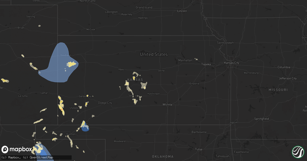
Hail Map in Kansas on July 5, 2025
Get this storm
July 5 map
$229
one time, instant access
Download today. No call, no setup
Keep the $229
Bought the map and want the full workflow? Apply the entire $229 to a subscription within 7 days. None of it is wasted.
Every map, not just this one
This buys you this map. Subscription and you get every map we run, in the markets you choose from a few cities to whole states to nationwide. Plus real-time alerts the moment a storm fires.
Contact data
Name, contact info, occupancy, even credit band for addresses in the footprint. You go from where it hit to who to call.
Become the source they trust
Unlimited branding weather history reports on demand. You already have the documented answer ready for the property owner, and you are the one who showed up with it.
Property data and RoofTrace estimates
Pull up any address you have got, its value and the exact code rules for that jurisdiction, straight from One Click Code. Then RoofTrace estimates the squares, pitch, and roof value, priced the way you price.
Storm reports in Kansas
Kansas
| Date | Description |
|---|---|
| 07/05/20256:05 PM CDT | A local report indicates 2.00 inch wind near Manter |
| 07/05/20256:00 PM CDT | A local report indicates 1.50 inch wind near Manter |
| 07/04/202511:20 PM CDT | Pws - nwkecounty. |
| 07/04/202511:09 PM CDT | Pws - kkslakin28. |
| 07/04/202510:53 PM CDT | Upr-mclas. |
| 07/04/202510:31 PM CDT | Site dw9439 reports 62 mph wind gust. |
| 07/04/202510:24 PM CDT | Site 5.5m e tribune ks reports 72 mph wind gust. |
| 07/04/202510:23 PM CDT | Site c6099 reports 59 mph wind gust. |
| 07/04/202510:13 PM CDT | Trained spotter estimates winds around 58 mph. Supported by sending in a video. |
| 07/04/202510:07 PM CDT | Spotter estimates 60 mph wind gusts and near zero visibility in rain on hwy 96 near ks/co border. |
| 07/04/20259:30 PM CDT | Cwop site gw6138. |
| 07/04/20258:00 PM CDT | Report made via social media. |
| 07/04/20257:57 PM CDT | Mesonet station up352 2.7 sw liberal |
| 07/04/20257:56 PM CDT | Awos station klbl liberal. |
All States Impacted by Hail Map on July 5, 2025
Cities Impacted by Hail Map on July 5, 2025
- Lodgepole, NE
- Dalton, NE
- Broadwater, NE
- Lisco, NE
- Marion, TX
- McQueeney, TX
- Seguin, TX
- New Braunfels, TX
- Bulverde, TX
- Custer, SD
- Reed Point, MT
- Big Timber, MT
- Pinedale, WY
- Bondurant, WY
- Cora, WY
- Molt, MT
- Hot Springs, SD
- Billings, MT
- Broadview, MT
- Huntley, MT
- Berthoud, CO
- Worden, MT
- Ballantine, MT
- Pompeys Pillar, MT
- Hardin, MT
- Buffalo Gap, SD
- West Point, NE
- Richton, MS
- Llano, TX
- Roundup, MT
- Saint Xavier, MT
- Dodge, NE
- Scribner, NE
- Moss Point, MS
- Crow Agency, MT
- Custer, MT
- Powell, WY
- Malta, MT
- Brooklyn, MS
- Perkinston, MS
- Wiggins, MS
- Bighorn, MT
- Eglin Afb, FL
- Roy, MT
- Lumberton, MS
- Hysham, MT
- Forsyth, MT
- Garryowen, MT
- Grand Bay, AL
- Syracuse, KS
- Ribera, NM
- Mobile, AL
- Lima, MT
- Pritchett, CO
- Grenville, NM
- Busby, MT
- Ocate, NM
- Lame Deer, MT
- Anton Chico, NM
- McLain, MS
- Clayton, NM
- Rosebud, MT
- Ingomar, MT
- Garden City, KS
- Manter, KS
- Johnson, KS
- Louin, MS
- Raleigh, MS
- Lucedale, MS
- Birney, MT
- Otter, MT
- Campo, CO
- Boise City, OK
- Rozel, KS
- Ashland, MT
- Ulysses, KS
- Benson, AZ
- Limon, CO
- Satanta, KS
- Larned, KS
- Otis, KS
- Molino, FL
- Cantonment, FL
- Genoa, CO
- Bison, KS
- Conchas Dam, NM
- Pierceville, KS
- Elkhart, KS
- Walsh, CO
- Robertsdale, AL
- Richfield, KS
- Hoisington, KS
- Ingalls, KS
- Texline, TX
- Sublette, KS
- Sedan, NM
- Dalhart, TX
- Springfield, CO
- Hugoton, KS
- Broadus, MT
- Alzada, MT
- Weston, WY
- McDavid, FL
- Denton, MT
- Hatfield, MO
- Hulett, WY
- Moorcroft, WY
- Aladdin, WY
- Liberal, KS
- Texhoma, OK
- Eagleville, MO
- Lewistown, MT
- Plains, KS
- Saint Marys, KS
- Hugo, CO
- Amistad, NM
- Otis, CO
- Kit Carson, CO
- Hilger, MT
- Flagler, CO
- Tyrone, OK
- Turpin, OK
- Hooker, OK
- Nara Visa, NM
- Yuma, CO
- Hartley, TX
- Belle Fourche, SD
- Sundance, WY
- Channing, TX
- Vega, TX
- Adrian, TX
- Beaver, OK
- Forgan, OK
- Logan, NM
- Tucumcari, NM
- Clearmont, MO
- Alva, WY
- Beulah, WY
- Spearfish, SD
- Saint Onge, SD
- San Jon, NM
- Santa Rosa, NM
- Burlington Junction, MO
- Belvue, KS
- Whitewood, SD
- Fort Meade, SD
- Sturgis, SD
- Nisland, SD
- Newell, SD
- Vale, SD
- Bard, NM
- Goodwell, OK
- Hereford, TX
- Wildorado, TX
- Amarillo, TX
- Colorado Springs, CO
- Piedmont, SD
- Box Elder, SD
- New Underwood, SD
- Owanka, SD
- Union Center, SD
- Idalia, CO
- Goodland, KS
- Sharon Springs, KS
- Eads, CO
- Weskan, KS
- Arapahoe, CO
- Tribune, KS
- Saint Francis, KS
- Burlington, CO
- Bethune, CO
- Kanorado, KS
- Sheridan Lake, CO
- Cheyenne Wells, CO
- Edson, KS
- Boone, CO
- Broadview, NM
- Mcalister, NM
- Gruver, TX
- Grady, NM
- Wallace, KS
- Melrose, NM
- Rapid City, SD
- Ellsworth Afb, SD
- Wasta, SD
- Enning, SD
- Osage, WY
- Upton, WY
- Winona, KS
- Spearman, TX
- Perryton, TX
- Newcastle, WY
- Claflin, KS
- Wall, SD
- Friona, TX
- Bovina, TX
- Muleshoe, TX
- Farwell, TX
- Summerfield, TX
- Dimmitt, TX
- Leoti, KS
- Colby, KS
- Monument, KS
- Dorrance, KS
- Wilson, KS
- Borger, TX
- Edgemont, SD
- Kadoka, SD
- Bunker Hill, KS
- Philip, SD
- Hill City, SD
- Russell, KS
- Lyons, KS
- Bushton, KS
- Chase, KS
- Ellinwood, KS
- Cuervo, NM
- White River, SD
- Long Valley, SD
- Hermosa, SD
- Miami, TX
- Albert, KS
- Rush Center, KS
- Keystone, SD
- Quinn, SD
- Raymond, KS
- Alden, KS
- Newkirk, NM
- Pawnee Rock, KS
- Lead, SD
- Great Bend, KS
- Sterling, KS
- Deadwood, SD
- Coffee Creek, MT
- Winifred, MT
- Nemo, SD
- St John, KS
- Stafford, KS
- Sylvia, KS
- Macksville, KS
- Iuka, KS
- Turon, KS
- Chadron, NE
- Valentine, NE
- Hay Springs, NE
- Moriarty, NM
- Rushville, NE
- Wood Lake, NE
- Pine Ridge, SD
- Tinnie, NM
- Vaughn, NM
- Ellsworth, NE
- Porcupine, SD
- Wounded Knee, SD
- Batesland, SD
- Wanblee, SD
- Manderson, SD
- Oglala, SD
- Martin, SD


