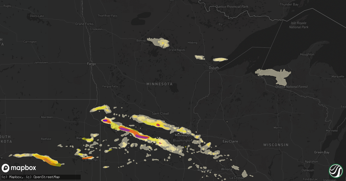
Hail Map in Minnesota on July 5, 2016
Get this storm
July 5 map
$229
one time, instant access
Download today. No call, no setup
Keep the $229
Bought the map and want the full workflow? Apply the entire $229 to a subscription within 7 days. None of it is wasted.
Every map, not just this one
This buys you this map. Subscription and you get every map we run, in the markets you choose from a few cities to whole states to nationwide. Plus real-time alerts the moment a storm fires.
Contact data
Name, contact info, occupancy, even credit band for addresses in the footprint. You go from where it hit to who to call.
Become the source they trust
Unlimited branding weather history reports on demand. You already have the documented answer ready for the property owner, and you are the one who showed up with it.
Property data and RoofTrace estimates
Pull up any address you have got, its value and the exact code rules for that jurisdiction, straight from One Click Code. Then RoofTrace estimates the squares, pitch, and roof value, priced the way you price.
Storm reports in Minnesota
Minnesota
| Date | Description |
|---|---|
| 07/05/20166:56 PM CDT | 14 to 16 inch diameter maple tree split just above the trunk and knocked over. |
| 07/05/20166:47 PM CDT | Large oak tree down on power lines. |
| 07/05/20166:45 PM CDT | . |
| 07/05/20166:28 PM CDT | Mesonet station richfield 2wsw /d1498/. |
| 07/05/20166:27 PM CDT | 18 inch diameter tree down. Time estimated. |
| 07/05/20166:27 PM CDT | 6 to 8 ft long tree branch down. |
| 07/05/20166:27 PM CDT | Rice and front street... 6 inch tree branch down on power lines. |
| 07/05/20166:20 PM CDT | . |
| 07/05/20166:16 PM CDT | . |
| 07/05/20166:16 PM CDT | 2 to 3 ft trees down blocking road. Reported at pierce and west broadway ave... Minneapolis... Mn. |
| 07/05/20166:15 PM CDT | 2 large trees down on road. |
| 07/05/20166:11 PM CDT | . |
| 07/05/20166:07 PM CDT | Mesonet station effm5. |
| 07/05/20166:02 PM CDT | Reported at york rd and vale ave... Hutchinson. |
| 07/05/20166:02 PM CDT | 6 to 8 inch diameter trees down. Time estimated by radar. |
| 07/05/20166:00 PM CDT | 12 inch tree down near city hall. Reported at hwy 55 and winnetka... Golden valley... Mn. |
| 07/05/20166:00 PM CDT | Photos of multiple trees down in the area. Largest trees were 2 to 3 feet in diameter. Time estimated by radar. |
| 07/05/20165:57 PM CDT | Mesonet station effm5. |
| 07/05/20165:55 PM CDT | . |
| 07/05/20165:54 PM CDT | Numerous repots of trees down and power out inf chanhassen this is one. Reported at galpin and pheasant trail chanhassen... Mn. |
| 07/05/20165:49 PM CDT | West facing siding torn off and shingles torn off on northwest corners of 3 houses. Reported at 30th st ne... And kale ave... St michael . |
| 07/05/20165:48 PM CDT | . |
| 07/05/20165:47 PM CDT | Reported at berkshire and dallas ln... Maple grove mn. |
| 07/05/20165:45 PM CDT | 10 inch diameter tree branch down. |
| 07/05/20165:45 PM CDT | Mndot sensor i-94 and mile marker 217. |
| 07/05/20165:45 PM CDT | Estimated 70 mph wind gusts. Lots of trees down across county roads in and near deer river. |
| 07/05/20165:44 PM CDT | 4 to 6 inch tree branch down. Reported at berkshire and dallas ln... Maple grove mn. |
| 07/05/20165:40 PM CDT | Large 2 ft diameter tree down. |
| 07/05/20165:40 PM CDT | . |
| 07/05/20165:38 PM CDT | . |
| 07/05/20165:30 PM CDT | Barn blown apart. Power pole also snapped here. |
| 07/05/20165:30 PM CDT | West facing siding torn off and shingles torn off on northwest corners of 3 houses. Reported at 30th st ne... And kale ave... St michael . |
| 07/05/20165:30 PM CDT | . |
| 07/05/20165:28 PM CDT | Couple of 8 to 10 inch diameter trees down. Power out. |
| 07/05/20165:25 PM CDT | Lots of trees down on highway 2 between mile marker 145 and mile marker 157. |
| 07/05/20165:21 PM CDT | Trees snapped or uprooted. . |
| 07/05/20165:14 PM CDT | Among sporadic tree damage... A 6 mile long string of transmission lines was destroyed. . |
| 07/05/20165:10 PM CDT | . |
| 07/05/20165:07 PM CDT | . |
| 07/05/20165:00 PM CDT | 20 inch diameter tree snapped about 20 ft up. Numerous 2 to 3 to 8 inch diameter branhes down. Reported at 118 jansen ave se... Hanover. |
| 07/05/20165:00 PM CDT | 50 ft boat flipped. Fire department sawing trees away from hwy 55. |
| 07/05/20165:00 PM CDT | . |
| 07/05/20165:00 PM CDT | . |
| 07/05/20165:00 PM CDT | Pole barn blown down debris on roadway. |
| 07/05/20164:57 PM CDT | Large tree down blocking hwy 55. |
| 07/05/20164:55 PM CDT | Widespread tree damage. Trees snapped off between south haven and annandale. |
| 07/05/20164:54 PM CDT | . |
| 07/05/20164:50 PM CDT | Multiple trees down up to 2 ft diameter between cold spring and kimball. |
| 07/05/20164:40 PM CDT | Lots of trees down. Time estimated. |
| 07/05/20164:38 PM CDT | Several large tree branches and limbs broken down in bemidji across roads and power lines. Estimated 50 to 60 mph winds. |
| 07/05/20164:35 PM CDT | 1.5 ft diameter tree uprooted at co rd 7 and 200th st. Reported in st. Augusta. . |
| 07/05/20164:32 PM CDT | A local report indicates 70 MPH wind near KIMBALL |
| 07/05/20164:15 PM CDT | 1 foot diameter branches down power lost. |
| 07/05/20164:10 PM CDT | Large tree down in yard. Time estimated. |
| 07/05/20164:09 PM CDT | A local report indicates 69 MPH wind near 1 N PAYNESVILLE |
| 07/05/20164:00 PM CDT | A local report indicates 1.00 inch wind near 8 SE DANVERS |
| 07/05/20163:05 PM CDT | Spotted on ground along hwy 59 to the ne of appleton. |
| 07/05/20162:55 PM CDT | Near hwy 59 and 200th ave. |
| 07/05/20162:36 PM CDT | Relayed via social media. Picture showed 1.5 to 2 inch hail stones. Time estimated via radar. |
| 07/05/20162:29 PM CDT | Radar estimated time. Delayed report. |
| 07/05/20161:50 PM CDT | Dime to quarter sized hail for a few minutes across far southern logan township. |
| 07/05/201612:50 PM CDT | A local report indicates 1.00 inch wind near 5 WSW DUMONT |
| 07/04/20169:52 PM CDT | Trees down and some branches partially blocking hwy 61 |
| 07/04/20169:49 PM CDT | Mesonet station 2 nnw zumbro falls /c7148/. |
| 07/04/20169:25 PM CDT | Numerous trees down across hwy 108. Road impassable. |
| 07/04/20169:23 PM CDT | Numerous large trees down / uprooted. The trees fell on 3 tents but no injuries or fatalities. Everyone had taken shelter. Confirmed by storm survey team all damage was |
| 07/04/20169:23 PM CDT | Home damaged and barn down |
| 07/04/20169:20 PM CDT | Lots of tree damage along hwy 63 near 700th st. Trees on road. |
| 07/04/20169:18 PM CDT | According to the city administrator...dozens of trees down...minor damage to a few buildings...a large building under construction on the north side of preston collapse |
| 07/04/20169:01 PM CDT | Cooperative observer stated trees down around the area and power out at farm place. Estimated time by radar. |
| 07/04/20168:58 PM CDT | 11 power poles down along st. Bridgets road in southwest rochester per rochester public utilities. A total of 2700 customers provided by rpu were without power. |
| 07/04/20168:56 PM CDT | A local report indicates 65 MPH wind near 1 W KASSON |
| 07/04/20168:55 PM CDT | Tree down on barn 3 miles east of bellchester along cr 9 near cr 82 |
| 07/04/20168:50 PM CDT | Trees down across hwy 60 blocking lanes east of mazeppa near cr 7. |
| 07/04/20168:50 PM CDT | A local report indicates 60 MPH wind near 6 NNW GENOA |
| 07/04/20168:50 PM CDT | Damage to grain bin and out buildings near bellchester |
| 07/04/20168:50 PM CDT | Peak wind gust measured 75 mph. Several power lines down and lots of trees down. |
| 07/04/20168:42 PM CDT | Reports of tornado on the ground from spotter near cr 10 and cr 77 just west of wabasha in pepin township. |
| 07/04/20168:42 PM CDT | Large tree down. |
| 07/04/20168:38 PM CDT | . |
| 07/04/20168:30 PM CDT | A few trees down and power lines down. |
| 07/04/20168:30 PM CDT | Large trees and branches down. Widespread power outages. |
| 07/04/20168:30 PM CDT | Trees down. Power lines down over a good part of town.... |
| 07/04/20168:24 PM CDT | Numerous trees down up to 1.5 ft diameter. . |
| 07/04/20168:20 PM CDT | Barn damage. Trees down. Power lines down. |
| 07/04/20168:20 PM CDT | . |
| 07/04/20168:18 PM CDT | 3 to 4 trees snapped. |
| 07/04/20168:15 PM CDT | Tree down on hwy 52. Time estimated. |
| 07/04/20168:15 PM CDT | This ef1 tornado snapped off several hardwood trees and the damage was convergent. Other damage was noted in the nearby area and it was caused by straight line winds es |
| 07/04/20168:15 PM CDT | Tree down on cr 9. Time estimated. |
| 07/04/20168:13 PM CDT | Significant roof and siding damage to metal agricultural buildings. Several trees down. . |
| 07/04/20168:10 PM CDT | Mesonet station cannon falls 7sse /mn042/. |
| 07/04/20168:10 PM CDT | Minor tree and roof damage in burnsville. Ping pong ball sized hail. Time reported is time received via social media. |
| 07/04/20168:00 PM CDT | 2.5 ft diameter oak tree down. Time estimated. Reported via facebook. . |
| 07/04/20167:54 PM CDT | Concentrated tree damage. |
| 07/04/20167:52 PM CDT | A local report indicates 1.00 inch wind near FARMINGTON |
| 07/04/20167:45 PM CDT | Measured by public weather station. |
| 07/04/20167:42 PM CDT | Time estimated. Damage- high tension power lines |
| 07/04/20167:40 PM CDT | Section of large privacy fence blown down. Reported at mc andrews road... Burnsville... Mn. |
| 07/04/20167:40 PM CDT | Siding off house. 6 inch tree blown into and through the house. Like a torpedo. |
| 07/04/20167:40 PM CDT | 1.5ft diameter fallen tree limb damaged car. Reported via facebook. . |
| 07/04/20167:39 PM CDT | Ef1 tornado developed just east of cannon city and tracked ese for about 3.7 miles. Trees were uprooted and a branch completely impaled an outside wall of a home. Estim |
| 07/04/20167:38 PM CDT | Large trees and power lines downed. Time estimated from radar. |
| 07/04/20167:35 PM CDT | Scattered trees down across town. |
| 07/04/20167:30 PM CDT | Large trees branches down. |
| 07/04/20167:25 PM CDT | Bass lake rd west bound at nottingham parkway - street light arm is bent so far that lights no longer point at traffic lanes. Arm is twisted about 45 degrees from corre |
| 07/04/20167:25 PM CDT | Hand held anemometer. Reported at hwy 13 and cr 42 streer... Savage... Mn. |
| 07/04/20167:25 PM CDT | Siding ripped off house new construction. Reported at hwy 13 and 160th streer... Prior lake... Mn. |
| 07/04/20167:25 PM CDT | Tree down on power line. |
| 07/04/20167:15 PM CDT | Several 6 inch branches down near city hall sw corner of i-35 and -694. |
| 07/04/20167:14 PM CDT | . |
| 07/04/20167:00 PM CDT | 20 inch diameter tree down. Reported at 36 th and winnetka... New hope. Time estimated. |
All States Impacted by Hail Map on July 5, 2016
Cities Impacted by Hail Map on July 5, 2016
- Highmore, SD
- Rexford, KS
- Hoxie, KS
- Oakley, KS
- Greenwood, NE
- Ashland, NE
- Holton, KS
- Muscotah, KS
- Whiting, KS
- Mineral Point, WI
- Rising City, NE
- Bellwood, NE
- Bruno, NE
- David City, NE
- Brainard, NE
- Dwight, NE
- Atlanta, KS
- Leon, KS
- Douglass, KS
- Atlanta, IL
- Cambridge, WI
- Andover, KS
- Augusta, KS
- Glencoe, MN
- Goldsmith, TX
- Mondamin, IA
- Lowell, IN
- Blue River, WI
- Boscobel, WI
- Gays Mills, WI
- Union Center, SD
- Goddard, KS
- Minneapolis, MN
- Saint Paul, MN
- Lubbock, TX
- Young America, MN
- Plato, MN
- Norwood Young America, MN
- Lester Prairie, MN
- Marenisco, MI
- Benson, MN
- Belle Plaine, MN
- Litchfield, MN
- Murdock, MN
- Jordan, MN
- Carver, MN
- Stewart, MN
- New Prague, MN
- Cologne, MN
- Brownton, MN
- Henderson, MN
- Kerkhoven, MN
- Hamburg, MN
- Bird Island, MN
- Hector, MN
- Maynard, MN
- Hutchinson, MN
- Milan, MN
- Raymond, MN
- Prinsburg, MN
- Cosmos, MN
- Clara City, MN
- Arlington, MN
- Olivia, MN
- Green Isle, MN
- Blomkest, MN
- Lake Lillian, MN
- Danvers, MN
- Buffalo Lake, MN
- Willmar, MN
- Montevideo, MN
- Hill City, KS
- Morland, KS
- Penokee, KS
- Ontonagon, MI
- Woodman, WI
- Prairie Du Chien, WI
- Wauzeka, WI
- Mount Hope, WI
- Hastings, MN
- Farmington, MN
- Rosemount, MN
- Lyman, NE
- Ivanhoe, MN
- Bazine, KS
- Ness City, KS
- Ohiowa, NE
- Milligan, NE
- Tobias, NE
- Newell, SD
- Spring Valley, WI
- Maiden Rock, WI
- Ellsworth, WI
- Bay City, WI
- Elmwood, WI
- Emington, IL
- Wichita, KS
- Cheyenne, WY
- Meriden, WY
- Albin, WY
- Lagrange, WY
- Spring Green, WI
- Arena, WI
- New Underwood, SD
- Sturgis, SD
- Black Earth, WI
- Mazomanie, WI
- Cross Plains, WI
- Sauk City, WI
- Scribner, NE
- Manteno, IL
- Sterling, IL
- Pontiac, IL
- Fairbury, IL
- Vail, IA
- Denison, IA
- Maddock, ND
- Shelby, NE
- Columbus, NE
- Osceola, NE
- Longton, KS
- Oxford Junction, IA
- Lowden, IA
- Clarence, IA
- Rush Center, KS
- Rozel, KS
- Otis, KS
- Larned, KS
- Pawnee Rock, KS
- Selden, KS
- Plevna, KS
- Sylvia, KS
- Pleasant Plains, IL
- Brodnax, VA
- La Crosse, VA
- Bracey, VA
- Ebony, VA
- White Plains, VA
- Gasburg, VA
- Alpena, SD
- Huron, SD
- Cavour, SD
- Crystal Springs, MS
- Wakefield, MI
- Ironwood, MI
- Bessemer, MI
- Abernathy, TX
- Arkansaw, WI
- Somonauk, IL
- Leland, IL
- Waterman, IL
- Petersburg, TX
- Floydada, TX
- Midland, TX
- Stanton, TX
- Hastings, NE
- Batavia, IA
- Colona, IL
- Hillsdale, IL
- Geneseo, IL
- Fullerton, NE
- Lime Springs, IA
- Harmony, MN
- Canby, MN
- Gary, SD
- Oglesby, IL
- Tonica, IL
- Ottawa, IL
- Danbury, NE
- Eureka, KS
- Panora, IA
- Lyndon, IL
- Dixon, IL
- Rock Falls, IL
- Prophetstown, IL
- Morrison, IL
- Beldenville, WI
- Bruning, NE
- Prairie View, KS
- Lenora, KS
- Almena, KS
- Logan, KS
- Lake City, MN
- Stockton, IL
- Warren, IL
- Peotone, IL
- Bourbonnais, IL
- Kankakee, IL
- Haysville, KS
- Derby, KS
- Rose Hill, KS
- Mcconnell Afb, KS
- Alliance, NE
- Brookings, SD
- Chicago, IL
- Toddville, IA
- Cedar Rapids, IA
- Scales Mound, IL
- Shullsburg, WI
- Macon, NC
- Wall, SD
- Gore Springs, MS
- Duck Hill, MS
- Lamesa, TX
- New Hill, NC
- Duluth, MN
- Two Harbors, MN
- Maben, MS
- Mathiston, MS
- Donnelly, MN
- Ceresco, NE
- Oberlin, KS
- Lafayette, IN
- Garfield, KS
- Deer River, MN
- Natoma, KS
- Plainville, KS
- Oskaloosa, IA
- Leighton, IA
- Soldiers Grove, WI
- Hopkinton, IA
- Saint Francis, KS
- Delmar, IA
- Westville, IN
- Valparaiso, IN
- Marquette, NE
- Central City, NE
- Silver Creek, NE
- Palmer, NE
- Hampton, NE
- Clarks, NE
- Archer, NE
- Schuyler, NE
- Hordville, NE
- Hanover, IL
- Belview, MN
- Mondovi, WI
- Independence, WI
- Genoa, WI
- De Soto, WI
- Andrews, TX
- Tarzan, TX
- South Bend, IN
- Juniata, NE
- Doniphan, NE
- Wood River, NE
- Emerson, IA
- Hastings, IA
- Malvern, IA
- Nicollet, MN
- New Ulm, MN
- Courtland, MN
- Wolsey, SD
- Virgil, SD
- Estelline, SD
- Castlewood, SD
- Rogers, MN
- Champlin, MN
- Osseo, MN
- Maple Grove, MN
- Kirkland, IL
- Elm City, NC
- Monticello, IA
- Anamosa, IA
- Minatare, NE
- Saint Paul, NE
- Cairo, NE
- Grand Island, NE
- Dannebrog, NE
- Saint Libory, NE
- Bradley, IL
- Wessington, SD
- Ostrander, MN
- Le Roy, MN
- Spring Valley, MN
- Baylis, IL
- Chambersburg, IL
- Partridge, KS
- Pisgah, IA
- Norcatur, KS
- Norton, KS
- Arapahoe, NE
- Peterson, MN
- Lewiston, MN
- Rushford, MN
- Correll, MN
- Ortonville, MN
- Slayton, MN
- Fairfax, MN
- Franklin, MN
- Gibbon, MN
- Grinnell, KS
- Colby, KS
- Imperial, TX
- Stanton, IA
- Sugar Grove, IL
- Elburn, IL
- Aurora, IL
- West Point, NE
- Muscoda, WI
- Richland Center, WI
- Wakeeney, KS
- Ransom, KS
- Collyer, KS
- Utica, KS
- Brownell, KS
- Quinter, KS
- Chapman, NE
- Giltner, NE
- Snyder, TX
- Scooba, MS
- Kadoka, SD
- Revere, MN
- Lamberton, MN
- Walnut Grove, MN
- Lake Norden, SD
- Lake Preston, SD
- Erwin, SD
- Belgrade, MN
- Brooten, MN
- Viroqua, WI
- Readstown, WI
- Conway Springs, KS
- Milton, KS
- Latham, KS
- Waterloo, IA
- Tahoka, TX
- Vale, SD
- Nisland, SD
- Belle Fourche, SD
- Whitewood, SD
- Eddyville, IA
- Stockton, IA
- Appleton, MN
- Holloway, MN
- Coila, MS
- Winona, MS
- Pepin, WI
- Reads Landing, MN
- Alma, WI
- Wabasha, MN
- Red Wing, MN
- Frontenac, MN
- Hager City, WI
- Welch, MN
- Prescott, WI
- Nelson, WI
- Durand, WI
- Stockholm, WI
- Glenwood, MN
- Renville, MN
- Danube, MN
- Bennett, IA
- Wilton, IA
- Durant, IA
- Brodhead, WI
- Lake City, IA
- Lohrville, IA
- Wheatland, IA
- Goodwin, SD
- Strandburg, SD
- Chokio, MN
- Beulah, WY
- White Owl, SD
- Howes, SD
- Enning, SD
- Wasta, SD
- Saint Onge, SD
- Aladdin, WY
- Hollister, NC
- Omaha, NE
- Bellevue, NE
- Alexander, KS
- Arlington, SD
- Oregon, WI
- Belleville, WI
- Brooklyn, WI
- Arrowsmith, IL
- Le Roy, IL
- Ellsworth, IL
- Manilla, IA
- Loup City, NE
- Litchfield, NE
- Avalon, WI
- Effingham, KS
- Park, KS
- Middleton, WI
- Elk City, KS
- Minden, NE
- Geneseo, KS
- Edson, KS
- Tekamah, NE
- Herman, NE
- Hooper, NE
- Craig, NE
- Ackerly, TX
- Saginaw, MN
- Floodwood, MN
- Meadowlands, MN
- Alborn, MN
- Gail, TX
- Big Spring, TX
- Gainesville, TX
- Cass Lake, MN
- Harrold, SD
- Ree Heights, SD
- Holabird, SD
- Mitchell, NE
- Scottsbluff, NE
- Parsons, KS
- Anton, TX
- Walnut, IL
- Eldena, IL
- Harmon, IL
- Amboy, IL
- Howard, KS
- Grant Park, IL
- Momence, IL
- Bergland, MI
- Randolph, MN
- Hampton, MN
- Cannon Falls, MN
- Dodgeville, WI
- Lone Rock, WI
- Avoca, WI
- Cobb, WI
- Fennimore, WI
- Montfort, WI
- Gotham, WI
- Highland, WI
- Glenwood, IA
- Plattsmouth, NE
- Silver City, IA
- Pacific Junction, IA
- Montgomery, IL
- Oswego, IL
- Stromsburg, NE
- Afton, MN
- Lakeland, MN
- Hudson, WI
- Echo, MN
- Peoria, IL
- Coal Valley, IL
- Gibson City, IL
- Berwyn, IL
- Le Sueur, MN
- Le Center, MN
- Brandon, MS
- Bruce, SD
- Aurora, SD
- Volga, SD
- Bantry, ND
- Upham, ND
- Haven, KS
- Walker, IA
- Center Point, IA
- Vinton, IA
- Harvey, IA
- Pella, IA
- Shannon, IL
- Axtell, NE
- River Falls, WI
- Waterville, IA
- Harpers Ferry, IA
- Eastman, WI
- El Dorado, KS
- Paynesville, MN
- New London, MN
- Thorntown, IN
- Wood Lake, MN
- Hanley Falls, MN
- Granite Falls, MN
- Palisade, NE
- Blue Mounds, WI
- Ridgeway, WI
- Barneveld, WI
- Saint Pauls, NC
- Currie, MN
- Mount Hope, KS
- Colwich, KS
- Maize, KS
- Andale, KS
- Onawa, IA
- Lebanon, NE
- Dighton, KS
- Healy, KS
- Guthrie Center, IA
- Yale, IA
- Mass City, MI
- Martin, SD
- Worthington, IA
- Ewen, MI
- Clinton, MN
- Morris, MN
- Wilson, NC
- Wray, CO
- Vernon, CO
- West Salem, WI
- Sparta, WI
- Rockland, WI
- Bangor, WI
- Mindoro, WI
- Arnold, KS
- Dresden, KS
- Jennings, KS
- Edison, NE
- Bertrand, NE
- Oxford, NE
- Clayton, NC
- Thomasboro, IL
- Lake Elmo, MN
- Stoughton, WI
- Stratton, NE
- Sunburg, MN
- Pennock, MN
- Holland, MN
- Pipestone, MN
- Dow City, IA
- Arion, IA
- Dunlap, IA
- Milton, WI
- Janesville, WI
- Sparta, GA
- Lincoln, IL
- Waynesville, IL
- Lawndale, IL
- Beason, IL
- McLean, IL
- Sacred Heart, MN
- Kenyon, MN
- West Concord, MN
- Jetmore, KS
- New Raymer, CO
- Elk Falls, KS
- Hale Center, TX
- Pine Bluffs, WY
- Mantorville, MN
- Pine Island, MN
- Labolt, SD
- Revillo, SD
- Fairview, IL
- Stillwater, MN
- Decorah, IA
- Homer Glen, IL
- New Lenox, IL
- Mokena, IL
- Knoxville, IL
- Victoria, IL
- Dahinda, IL
- Oneida, IL
- Raleigh, NC
- Robersonville, NC
- Williamston, NC
- Pine Hill, AL
- Central City, IA
- Alburnett, IA
- Chetek, WI
- Wilsonville, NE
- Hendley, NE
- South Beloit, IL
- Beloit, WI
- Rockton, IL
- San Jose, IL
- Delavan, IL
- Emden, IL
- Monticello, WI
- New Glarus, WI
- Scenic, SD
- Dennison, MN
- Conrad, IA
- Union, IA
- Eldora, IA
- Hume, IL
- Toulon, IL
- Williamsfield, IL
- Laura, IL
- Darlington, SC
- Society Hill, SC
- Wall Lake, IA
- Auburn, IA
- Spearfish, SD
- Fosters, AL
- Columbia, NC
- Roodhouse, IL
- Annandale, MN
- South Haven, MN
- Kimball, MN
- Milledgeville, IL
- Mount Carroll, IL
- Lanark, IL
- Chadwick, IL
- Clinton, WI
- Philadelphia, MS
- Paxton, IL
- Marseilles, IL
- Eutaw, AL
- Stafford, KS
- Pelkie, MI
- Mullen, NE
- Mason City, NE
- Canyon, MN
- Clarkfield, MN
- Boyd, MN
- Lenorah, TX
- Knott, TX
- Tipton, IA
- Mcfarland, WI
- Cottage Grove, WI
- Morrisville, NC
- Durham, NC
- Collinsville, MS
- Little Rock, MS
- De Kalb, MS
- Union, MS
- Ryan, IA
- Buffalo, MN
- Newman, IL
- Polk, NE
- Bradshaw, NE
- Bogue Chitto, MS
- Niles, MI
- Kandiyohi, MN
- La Crosse, IN
- Wanatah, IN
- Kouts, IN
- Hoisington, KS
- Otis, CO
- Daleville, AL
- Enterprise, AL
- Sublette, IL
- Berthold, ND
- Fulton, IL
- Cedar, IA
- Albia, IA
- Bussey, IA
- Knoxville, IA
- Tracy, IA
- Gove, KS
- Northfield, MN
- Barnwell, SC
- Long Grove, IA
- Fairbury, NE
- Bruce Crossing, MI
- Watersmeet, MI
- Holly Springs, NC
- Apex, NC
- Garner, NC
- Deerfield, WI
- Sun Prairie, WI
- Madison, WI
- Woodville, MS
- Centreville, MS
- Norwood, LA
- Saint Francisville, LA
- Ashton, NE
- Elba, NE
- Albany, WI
- Evansville, WI
- Steward, IL
- Paw Paw, IL
- Astoria, SD
- Lake Zurich, IL
- Wauconda, IL
- Mundelein, IL
- Chatfield, MN
- Dover, MN
- Utica, MN
- Saint Charles, MN
- Porter, MN
- Hudson, IA
- Manhattan, IL
- Monee, IL
- Frankfort, IL
- University Park, IL
- Holdrege, NE
- Funk, NE
- Marshall, WI
- Waterloo, WI
- Lonsdale, MN
- Webster, MN
- Elko New Market, MN
- Union Mills, IN
- Milesville, SD
- Erie, IL
- Sterling, KS
- Prior Lake, MN
- Silver Lake, MN
- Woodbine, IA
- North Bend, NE
- Little Sioux, IA
- Polo, IL
- Windsor, NC
- Lewiston Woodville, NC
- Dumont, MN
- Linden, NC
- Fayetteville, NC
- Minter, AL
- Sleepy Eye, MN
- Red Oak, IA
- Nebo, NC
- Morganton, NC
- Eupora, MS
- Stantonsburg, NC
- Fountain, NC
- Phillips, NE
- Kenesaw, NE
- Alda, NE
- Trumbull, NE
- Summit, MS
- Kempton, IL
- Malta, IL
- De Witt, IA
- Hamlin, IA
- Kellogg, MN
- Federal Dam, MN
- Bloomington, WI
- Lancaster, WI
- Hamlet, IN
- Knox, IN
- Quinn, SD
- Decatur, NE
- Castana, IA
- Whiting, IA
- Clearwater, KS
- Viola, KS
- Norwich, KS
- Mason City, IL
- Mulvane, KS
- Peck, KS
- Belgrade, NE
- Gowrie, IA
- Callender, IA
- Ohio, IL
- Nerstrand, MN
- Cochrane, WI
- Altura, MN
- Loda, IL
- Big Rock, IL
- Hendricks, MN
- Bemidji, MN
- Lucama, NC
- Selma, NC
- Kenly, NC
- Sims, NC
- Zebulon, NC
- Middlesex, NC
- Pennington, MN
- Bena, MN
- Blackduck, MN
- Bouton, IA
- Granger, IA
- Woodward, IA
- Madrid, IA
- Bryant, SD
- Badger, SD
- Soso, MS
- Laurel, MS
- Lillington, NC
- Fuquay Varina, NC
- Severy, KS
- Saint Lawrence, SD
- Miller, SD
- Gainestown, AL
- Des Moines, IA
- Mendota, IL
- La Moille, IL
- Arlington, IL
- New Liberty, IA
- Treynor, IA
- Holmen, WI
- Ettrick, WI
- Melrose, WI
- Galesville, WI
- Saint Peter, MN
- Kasota, MN
- Quitman, MS
- Verona, WI
- Arcadia, WI
- Apple River, IL
- Ulysses, NE
- Aurora, NE
- Dodge, NE
- Rogers, NE
- Genoa, NE
- Weston, NE
- Valparaiso, NE
- Cleveland, MN
- Tremont, IL
- Beeler, KS
- Osborne, KS
- Waldo, KS
- Davis, IL
- Pecatonica, IL
- Kewanna, IN
- Lockport, IL
- Bison, KS
- McCracken, KS
- Liebenthal, KS
- La Crosse, KS
- Earlville, IL
- Ellsworth, KS
- Lorraine, KS
- Willow City, ND
- Towner, ND
- Michigan City, IN
- Chesterton, IN
- Stewartville, MN
- Racine, MN
- Roscoe, MN
- Cold Spring, MN
- Waverly, MN
- Watkins, MN
- Eden Valley, MN
- Maple Lake, MN
- Clearwater, MN
- Richmond, MN
- Grove City, MN
- Monticello, MN
- Gorham, KS
- Hays, KS
- Pfeifer, KS
- Victoria, KS
- Russell, KS
- Hammond, IN
- Vossburg, MS
- Paulding, MS
- Cambridge, NE
- Holbrook, NE
- Scotland Neck, NC
- Pelahatchie, MS
- Mapleton, IA
- Hornick, IA
- Cherry Valley, IL
- Rockford, IL
- Houlton, WI
- Fredonia, KS
- Norwalk, WI
- Coggon, IA
- Masonville, IA
- Manchester, IA
- Winthrop, IA
- Greenwood, MS
- New Albin, IA
- Westby, WI
- Ferryville, WI
- Brownsville, MN
- Caledonia, MN
- Eitzen, MN
- Chaseburg, WI
- Watertown, SD
- Clear Lake, SD
- Onarga, IL
- Cuba, IL
- Canton, IL
- Durand, IL
- Winnebago, IL
- Bellflower, IL
- Lynn Center, IL
- Osco, IL
- Orion, IL
- Claremont, MN
- Owatonna, MN
- Hamel, MN
- Garrison, IA
- Dysart, IA
- Urbana, IA
- Delphi, IN
- Rossville, IN
- Cohasset, MN
- Grand Rapids, MN
- Compton, IL
- West Brooklyn, IL
- Jefferson, IA
- Eckley, CO
- Yuma, CO
- Rochester, MN
- Eyota, MN
- Odell, IL
- Sanborn, MN
- Elmwood, IL
- Oto, IA
- Sylvan Grove, KS
- Heidelberg, MS
- Byron, IL
- Stillman Valley, IL
- Garden Plain, KS
- Hutchinson, KS
- Browns Valley, MN
- Alberta, MN
- Beardsley, MN
- Wheaton, MN
- Herman, MN
- Romney, IN
- Arlington, AL
- Chillicothe, IL
- Mossville, IL
- Otoe, NE
- Lake Village, IN
- Lusk, WY
- Cottonwood, AL
- Slocomb, AL
- Hancock, MN
- Mapleton, IL
- Enfield, NC
- Deforest, WI
- Decatur, IL
- Wolfforth, TX
- Wilson, TX
- Bancroft, NE
- Lyons, NE
- Green Valley, IL
- Smithdale, MS
- Welch, TX
- Walker, KS
- Paradise, KS
- Mount Horeb, WI
- Walcott, IA
- Van Horne, IA
- Newhall, IA
- Palo, IA
- Shellsburg, IA
- Atkins, IA
- Polk City, IA
- Hemingford, NE
- New Cambria, KS
- Salina, KS
- Garden City, TX
- Bunker Hill, KS
- Dorrance, KS
- Newark, IL
- Minden, IA
- Lincoln, KS
- Louisburg, NC
- Youngsville, NC
- Franklinton, NC
- Doland, SD
- Rule, TX
- Deloit, IA
- Godfrey, IL
- Dow, IL
- Jerseyville, IL
- Jewell, IA
- Ellsworth, IA
- Tracy, MN
- Ottumwa, IA
- Hartford, IA
- Carlisle, IA
- Redfield, IA
- Conehatta, MS
- Claremont, NC
- Albert, KS
- Marion, IA
- Saint Michael, MN
- Beaman, IA
- Grundy Center, IA
- Rockwell City, IA
- Dane, WI
- Exira, IA
- Casey, IA
- Adair, IA
- Anita, IA
- Hobart, IN
- Aliceville, AL
- Clifton, IL
- Chebanse, IL
- Neodesha, KS
- Turon, KS
- Knoxville, AL
- Grand Mound, IA
- Lost Nation, IA
- Port Orange, FL
- Plainview, TX
- Zwingle, IA
- Kearney, NE
- Elm Creek, NE
- Buffalo Grove, IL
- Plainfield, IL
- Romeoville, IL
- Cullom, IL
- Chatsworth, IL
- Fox Lake, IL
- Mchenry, IL
- Round Lake, IL
- Ingleside, IL
- Sabula, IA
- Thomson, IL
- Taylorsville, MS
- Selma, IA
- Libertyville, IA
- Wahoo, NE
- Benedict, KS
- Hanover, MN
- Eatonton, GA
- Idalia, CO
- Gardner, IL
- Reddick, IL
- Burdett, KS
- Madison Lake, MN
- Melrose, MN
- Maple Plain, MN
- Circle Pines, MN
- Anoka, MN
- Dayton, MN
- Rockford, MN
- Dassel, MN
- Howard Lake, MN
- Loretto, MN
- Delano, MN
- Cottage Grove, MN
- Albertville, MN
- Ropesville, TX
- Lewistown, MO
- Oakland, NE
- Breda, IA
- Carroll, IA
- Glidden, IA
- Fall River, KS
- Streator, IL
- Autryville, NC
- Wade, NC
- Godwin, NC
- Winchester, IL
- West Point, IA
- Blue Grass, IA
- Hayden, CO
- Carpenter, SD
- Camanche, IA
- Donahue, IA
- McCausland, IA
- Princeton, IA
- Eldridge, IA
- Willow Lake, SD
- Altamont, KS
- Edna, KS
- Coffeyville, KS
- Wilson, KS
- Forrest, IL
- Cascade, IA
- Onslow, IA
- Camp Point, IL
- Liberty, IL
- Clayton, IL
- Seminole, TX
- Yorkville, IL
- Monroeville, AL
- Frisco City, AL
- Udall, KS
- Harlan, IA
- McCarley, MS
- Gretna, NE
- Pearl City, IL
- Minooka, IL
- Cherryvale, KS
- Oronoco, MN
- Byron, MN
- Clinton, IL
- Kenney, IL
- Maroa, IL
- Davis Junction, IL
- Monroe Center, IL
- Macon, GA
- Vienna, SD
- Yates City, IL
- Magnolia, MS
- Farwell, MN
- Hanston, KS
- Ellis, KS
- Ogallah, KS
- Nekoma, KS
- Bellevue, IA
- Spragueville, IA
- Minburn, IA
- Springfield, MN
- St John, KS
- Macksville, KS
- Waukee, IA
- Fort Atkinson, WI
- Kramer, ND
- Clive, IA
- Urbandale, IA
- Thomasville, AL
- Farmington, IL
- Iroquois, SD
- Artesian, SD
- Carthage, SD
- Halifax, NC
- Monument, KS
- Crown Point, IN
- Oakland, IA
- Millry, AL
- Camden, AL
- Downers Grove, IL
- Willowbrook, IL
- Darien, IL
- Woodridge, IL
- Cheney, KS
- Hubbard, IA
- Agency, IA
- Harvard, IL
- Midland, GA
- Cottonwood, MN
- Hay Springs, NE
- Mechanicsville, IA
- Barrington, IL
- Bayard, NE
- Gering, NE
- Pembroke Township, IL
- Oakwood, IL
- Buhl, AL
- Tuscaloosa, AL
- Ralph, AL
- Clinton, LA
- Monroe, WI
- Portage, IN
- Grand Junction, IA
- Rippey, IA
- Houston, MN
- Fremont, IA
- Sandwich, IL
- Belvidere, SD
- Pittsboro, NC
- Ransom, IL
- Blackstone, IL
- Platteville, WI
- Saratoga, WY
- Kent, IL
- Preston, IA
- Danville, GA
- Irwinton, GA
- Culver, IN
- Monterey, IN
- Easton, IL
- Griggsville, IL
- Linden, IA
- Chocowinity, NC
- Starbuck, MN
- Phillipsburg, KS
- Birmingham, IA
- Fairfield, IA
- Milroy, MN
- Vesta, MN
- Elberon, IA
- Keystone, IA
- Monticello, MO
- Altoona, KS
- Raleigh, MS
- Hamilton, NC
- Oak City, NC
- Tarboro, NC
- Hobgood, NC
- Bethel, NC
- Cary, NC
- Chapel Hill, NC
- Van Orin, IL
- La Porte City, IA
- Elizabeth, IL
- Mount Vernon, IA
- Gresham, NE
- Valley View, TX
- Rantoul, IL
- Gifford, IL
- Waverly, NE
- Cuba City, WI
- Benton, WI
- Springfield, IL
- Baker, FL
- Viola, IL
- New Windsor, IL
- Pleasant Valley, IA
- Taylor Ridge, IL
- Milan, IL
- Moline, IL
- Rock Island, IL
- Buffalo, IA
- Bettendorf, IA
- East Moline, IL
- Hampton, IL
- Le Claire, IA
- Silvis, IL
- Davenport, IA
- Sherrard, IL
- Andalusia, IL
- Muscatine, IA
- Osyka, MS
- Strawn, IL
- Sibley, IL
- Quincy, IL
- Lanesboro, MN
- Luray, KS
- Lucas, KS
- Ogden, IA
- Saint Paul, IA
- Stedman, NC
- Brimfield, IL
- Donnellson, IA
- Council Bluffs, IA
- Henderson, IA
- Shabbona, IL
- Marion, NC
- Joliet, IL
- Bosler, WY
- Waunakee, WI
- Lakeville, MN
- Montgomery, MN
- Dundas, MN
- New Germany, MN
- Faribault, MN
- Mayer, MN
- Riverdale, IL
- Blue Island, IL
- Grainfield, KS
- Palos Heights, IL
- Orland Park, IL
- Cresco, IA
- Steuben, WI
- Trenton, NE
- Savanna, IL
- Jackson, LA
- Winona, KS
- Clayton, KS
- Winthrop, MN
- Bigfork, MN
- Effie, MN
- Claflin, KS
- Rowley, IA
- Quasqueton, IA
- Fair Oaks, IN
- Olney, TX
- Tuthill, SD
- Calamus, IA
- Dixon, IA
- Grenola, KS
- Rock, KS
- Winfield, KS
- Cambridge, KS
- Broadview, IL
- Riverside, IL
- Westchester, IL
- Chrisman, IL
- Clinton, IN
- Dana, IN
- Plum City, WI
- Pine Ridge, SD
- Footville, WI
- Eldon, IA
- Redwood Falls, MN
- Spring Hope, NC
- White, SD
- Elkton, SD
- Toronto, SD
- Linden, WI
- Darlington, WI
- Rewey, WI
- Nashville, NC
- Bryant, IA
- Goose Lake, IA
- Willow Spring, NC
- Odessa, NE
- Remer, MN
- Mead, NE
- Neola, IA
- Sidell, IL
- Maquoketa, IA
- Silas, AL
- Lizella, GA
- Taunton, MN
- Minneota, MN
- Charlotte, IA
- Oak Creek, CO
- Swanton, NE
- Western, NE
- Chester, IA
- Preston, MN
- Menlo, IA
- Stuart, IA
- Rugby, ND
- New Rockford, ND
- Sheyenne, ND
- Littlefield, TX
- Woonsocket, SD


