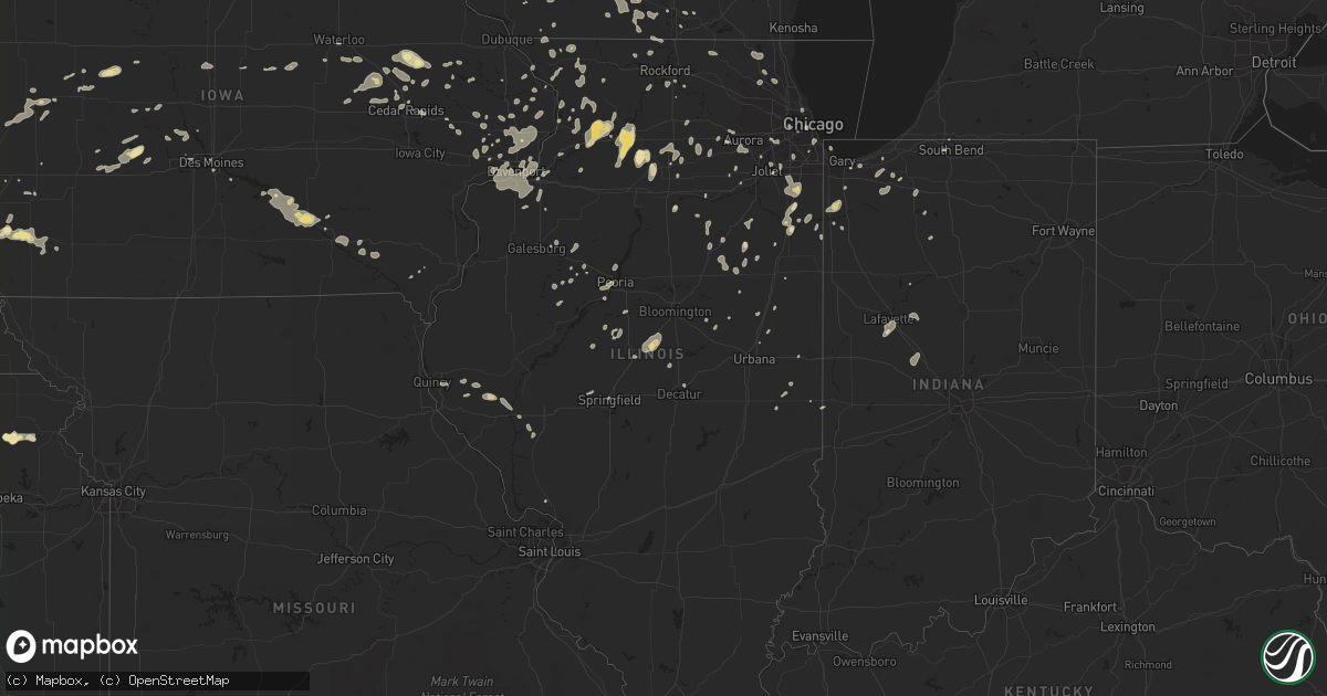
Hail Map in Illinois on July 5, 2016
Get this storm
July 5 map
$229
one time, instant access
Download today. No call, no setup
Keep the $229
Bought the map and want the full workflow? Apply the entire $229 to a subscription within 7 days. None of it is wasted.
Every map, not just this one
This buys you this map. Subscription and you get every map we run, in the markets you choose from a few cities to whole states to nationwide. Plus real-time alerts the moment a storm fires.
Contact data
Name, contact info, occupancy, even credit band for addresses in the footprint. You go from where it hit to who to call.
Become the source they trust
Unlimited branding weather history reports on demand. You already have the documented answer ready for the property owner, and you are the one who showed up with it.
Property data and RoofTrace estimates
Pull up any address you have got, its value and the exact code rules for that jurisdiction, straight from One Click Code. Then RoofTrace estimates the squares, pitch, and roof value, priced the way you price.
Storm reports in Illinois
Illinois
| Date | Description |
|---|---|
| 07/05/20164:20 AM CDT | Power pole down |
| 07/05/20164:15 AM CDT | Large trees down. Time estimated from radar. |
| 07/05/20163:18 AM CDT | Aluminum flagpole bent over and snapped off. Branches off trees. Aluminum panels pulled off fascia on home. Relayed via twitter. Time estimated by radar. |
| 07/05/20163:00 AM CDT | Several large trees down along oaklane drive. Relayed via facebook. |
| 07/05/20162:47 AM CDT | Scattered tree limbs up to 4 inches in diameter down throughout town. Relayed via twitter. Time estimated by radar. |
| 07/05/20162:46 AM CDT | Tree down on a car across callan avenue near howard street in evanston. Time estimated by radar. |
| 07/05/20162:00 AM CDT | Trees down just west of downtown. |
| 07/05/20161:54 AM CDT | Time estimated - strong winds blew a tree onto power lines and damaged power pole. |
| 07/05/20161:34 AM CDT | Large branch/portion of tree down onto fence...destroying the fence and lying into neighboring yard. Relayed via facebook. Time estimated by radar. |
| 07/05/20161:15 AM CDT | 1 large tree limb down with numerous smaller ones. Report was delayed. |
| 07/05/201612:35 AM CDT | Trees reported down near council hill road and w east road. Time estimated. |
| 07/05/201612:35 AM CDT | Trees down near guilford road and stagecoach trail. Time estimated. |
All States Impacted by Hail Map on July 5, 2016
Cities Impacted by Hail Map on July 5, 2016
- Highmore, SD
- Rexford, KS
- Hoxie, KS
- Oakley, KS
- Greenwood, NE
- Ashland, NE
- Holton, KS
- Muscotah, KS
- Whiting, KS
- Mineral Point, WI
- Rising City, NE
- Bellwood, NE
- Bruno, NE
- David City, NE
- Brainard, NE
- Dwight, NE
- Atlanta, KS
- Leon, KS
- Douglass, KS
- Atlanta, IL
- Cambridge, WI
- Andover, KS
- Augusta, KS
- Glencoe, MN
- Goldsmith, TX
- Mondamin, IA
- Lowell, IN
- Blue River, WI
- Boscobel, WI
- Gays Mills, WI
- Union Center, SD
- Goddard, KS
- Minneapolis, MN
- Saint Paul, MN
- Lubbock, TX
- Young America, MN
- Plato, MN
- Norwood Young America, MN
- Lester Prairie, MN
- Marenisco, MI
- Benson, MN
- Belle Plaine, MN
- Litchfield, MN
- Murdock, MN
- Jordan, MN
- Carver, MN
- Stewart, MN
- New Prague, MN
- Cologne, MN
- Brownton, MN
- Henderson, MN
- Kerkhoven, MN
- Hamburg, MN
- Bird Island, MN
- Hector, MN
- Maynard, MN
- Hutchinson, MN
- Milan, MN
- Raymond, MN
- Prinsburg, MN
- Cosmos, MN
- Clara City, MN
- Arlington, MN
- Olivia, MN
- Green Isle, MN
- Blomkest, MN
- Lake Lillian, MN
- Danvers, MN
- Buffalo Lake, MN
- Willmar, MN
- Montevideo, MN
- Hill City, KS
- Morland, KS
- Penokee, KS
- Ontonagon, MI
- Woodman, WI
- Prairie Du Chien, WI
- Wauzeka, WI
- Mount Hope, WI
- Hastings, MN
- Farmington, MN
- Rosemount, MN
- Lyman, NE
- Ivanhoe, MN
- Bazine, KS
- Ness City, KS
- Ohiowa, NE
- Milligan, NE
- Tobias, NE
- Newell, SD
- Spring Valley, WI
- Maiden Rock, WI
- Ellsworth, WI
- Bay City, WI
- Elmwood, WI
- Emington, IL
- Wichita, KS
- Cheyenne, WY
- Meriden, WY
- Albin, WY
- Lagrange, WY
- Spring Green, WI
- Arena, WI
- New Underwood, SD
- Sturgis, SD
- Black Earth, WI
- Mazomanie, WI
- Cross Plains, WI
- Sauk City, WI
- Scribner, NE
- Manteno, IL
- Sterling, IL
- Pontiac, IL
- Fairbury, IL
- Vail, IA
- Denison, IA
- Maddock, ND
- Shelby, NE
- Columbus, NE
- Osceola, NE
- Longton, KS
- Oxford Junction, IA
- Lowden, IA
- Clarence, IA
- Rush Center, KS
- Rozel, KS
- Otis, KS
- Larned, KS
- Pawnee Rock, KS
- Selden, KS
- Plevna, KS
- Sylvia, KS
- Pleasant Plains, IL
- Brodnax, VA
- La Crosse, VA
- Bracey, VA
- Ebony, VA
- White Plains, VA
- Gasburg, VA
- Alpena, SD
- Huron, SD
- Cavour, SD
- Crystal Springs, MS
- Wakefield, MI
- Ironwood, MI
- Bessemer, MI
- Abernathy, TX
- Arkansaw, WI
- Somonauk, IL
- Leland, IL
- Waterman, IL
- Petersburg, TX
- Floydada, TX
- Midland, TX
- Stanton, TX
- Hastings, NE
- Batavia, IA
- Colona, IL
- Hillsdale, IL
- Geneseo, IL
- Fullerton, NE
- Lime Springs, IA
- Harmony, MN
- Canby, MN
- Gary, SD
- Oglesby, IL
- Tonica, IL
- Ottawa, IL
- Danbury, NE
- Eureka, KS
- Panora, IA
- Lyndon, IL
- Dixon, IL
- Rock Falls, IL
- Prophetstown, IL
- Morrison, IL
- Beldenville, WI
- Bruning, NE
- Prairie View, KS
- Lenora, KS
- Almena, KS
- Logan, KS
- Lake City, MN
- Stockton, IL
- Warren, IL
- Peotone, IL
- Bourbonnais, IL
- Kankakee, IL
- Haysville, KS
- Derby, KS
- Rose Hill, KS
- Mcconnell Afb, KS
- Alliance, NE
- Brookings, SD
- Chicago, IL
- Toddville, IA
- Cedar Rapids, IA
- Scales Mound, IL
- Shullsburg, WI
- Macon, NC
- Wall, SD
- Gore Springs, MS
- Duck Hill, MS
- Lamesa, TX
- New Hill, NC
- Duluth, MN
- Two Harbors, MN
- Maben, MS
- Mathiston, MS
- Donnelly, MN
- Ceresco, NE
- Oberlin, KS
- Lafayette, IN
- Garfield, KS
- Deer River, MN
- Natoma, KS
- Plainville, KS
- Oskaloosa, IA
- Leighton, IA
- Soldiers Grove, WI
- Hopkinton, IA
- Saint Francis, KS
- Delmar, IA
- Westville, IN
- Valparaiso, IN
- Marquette, NE
- Central City, NE
- Silver Creek, NE
- Palmer, NE
- Hampton, NE
- Clarks, NE
- Archer, NE
- Schuyler, NE
- Hordville, NE
- Hanover, IL
- Belview, MN
- Mondovi, WI
- Independence, WI
- Genoa, WI
- De Soto, WI
- Andrews, TX
- Tarzan, TX
- South Bend, IN
- Juniata, NE
- Doniphan, NE
- Wood River, NE
- Emerson, IA
- Hastings, IA
- Malvern, IA
- Nicollet, MN
- New Ulm, MN
- Courtland, MN
- Wolsey, SD
- Virgil, SD
- Estelline, SD
- Castlewood, SD
- Rogers, MN
- Champlin, MN
- Osseo, MN
- Maple Grove, MN
- Kirkland, IL
- Elm City, NC
- Monticello, IA
- Anamosa, IA
- Minatare, NE
- Saint Paul, NE
- Cairo, NE
- Grand Island, NE
- Dannebrog, NE
- Saint Libory, NE
- Bradley, IL
- Wessington, SD
- Ostrander, MN
- Le Roy, MN
- Spring Valley, MN
- Baylis, IL
- Chambersburg, IL
- Partridge, KS
- Pisgah, IA
- Norcatur, KS
- Norton, KS
- Arapahoe, NE
- Peterson, MN
- Lewiston, MN
- Rushford, MN
- Correll, MN
- Ortonville, MN
- Slayton, MN
- Fairfax, MN
- Franklin, MN
- Gibbon, MN
- Grinnell, KS
- Colby, KS
- Imperial, TX
- Stanton, IA
- Sugar Grove, IL
- Elburn, IL
- Aurora, IL
- West Point, NE
- Muscoda, WI
- Richland Center, WI
- Wakeeney, KS
- Ransom, KS
- Collyer, KS
- Utica, KS
- Brownell, KS
- Quinter, KS
- Chapman, NE
- Giltner, NE
- Snyder, TX
- Scooba, MS
- Kadoka, SD
- Revere, MN
- Lamberton, MN
- Walnut Grove, MN
- Lake Norden, SD
- Lake Preston, SD
- Erwin, SD
- Belgrade, MN
- Brooten, MN
- Viroqua, WI
- Readstown, WI
- Conway Springs, KS
- Milton, KS
- Latham, KS
- Waterloo, IA
- Tahoka, TX
- Vale, SD
- Nisland, SD
- Belle Fourche, SD
- Whitewood, SD
- Eddyville, IA
- Stockton, IA
- Appleton, MN
- Holloway, MN
- Coila, MS
- Winona, MS
- Pepin, WI
- Reads Landing, MN
- Alma, WI
- Wabasha, MN
- Red Wing, MN
- Frontenac, MN
- Hager City, WI
- Welch, MN
- Prescott, WI
- Nelson, WI
- Durand, WI
- Stockholm, WI
- Glenwood, MN
- Renville, MN
- Danube, MN
- Bennett, IA
- Wilton, IA
- Durant, IA
- Brodhead, WI
- Lake City, IA
- Lohrville, IA
- Wheatland, IA
- Goodwin, SD
- Strandburg, SD
- Chokio, MN
- Beulah, WY
- White Owl, SD
- Howes, SD
- Enning, SD
- Wasta, SD
- Saint Onge, SD
- Aladdin, WY
- Hollister, NC
- Omaha, NE
- Bellevue, NE
- Alexander, KS
- Arlington, SD
- Oregon, WI
- Belleville, WI
- Brooklyn, WI
- Arrowsmith, IL
- Le Roy, IL
- Ellsworth, IL
- Manilla, IA
- Loup City, NE
- Litchfield, NE
- Avalon, WI
- Effingham, KS
- Park, KS
- Middleton, WI
- Elk City, KS
- Minden, NE
- Geneseo, KS
- Edson, KS
- Tekamah, NE
- Herman, NE
- Hooper, NE
- Craig, NE
- Ackerly, TX
- Saginaw, MN
- Floodwood, MN
- Meadowlands, MN
- Alborn, MN
- Gail, TX
- Big Spring, TX
- Gainesville, TX
- Cass Lake, MN
- Harrold, SD
- Ree Heights, SD
- Holabird, SD
- Mitchell, NE
- Scottsbluff, NE
- Parsons, KS
- Anton, TX
- Walnut, IL
- Eldena, IL
- Harmon, IL
- Amboy, IL
- Howard, KS
- Grant Park, IL
- Momence, IL
- Bergland, MI
- Randolph, MN
- Hampton, MN
- Cannon Falls, MN
- Dodgeville, WI
- Lone Rock, WI
- Avoca, WI
- Cobb, WI
- Fennimore, WI
- Montfort, WI
- Gotham, WI
- Highland, WI
- Glenwood, IA
- Plattsmouth, NE
- Silver City, IA
- Pacific Junction, IA
- Montgomery, IL
- Oswego, IL
- Stromsburg, NE
- Afton, MN
- Lakeland, MN
- Hudson, WI
- Echo, MN
- Peoria, IL
- Coal Valley, IL
- Gibson City, IL
- Berwyn, IL
- Le Sueur, MN
- Le Center, MN
- Brandon, MS
- Bruce, SD
- Aurora, SD
- Volga, SD
- Bantry, ND
- Upham, ND
- Haven, KS
- Walker, IA
- Center Point, IA
- Vinton, IA
- Harvey, IA
- Pella, IA
- Shannon, IL
- Axtell, NE
- River Falls, WI
- Waterville, IA
- Harpers Ferry, IA
- Eastman, WI
- El Dorado, KS
- Paynesville, MN
- New London, MN
- Thorntown, IN
- Wood Lake, MN
- Hanley Falls, MN
- Granite Falls, MN
- Palisade, NE
- Blue Mounds, WI
- Ridgeway, WI
- Barneveld, WI
- Saint Pauls, NC
- Currie, MN
- Mount Hope, KS
- Colwich, KS
- Maize, KS
- Andale, KS
- Onawa, IA
- Lebanon, NE
- Dighton, KS
- Healy, KS
- Guthrie Center, IA
- Yale, IA
- Mass City, MI
- Martin, SD
- Worthington, IA
- Ewen, MI
- Clinton, MN
- Morris, MN
- Wilson, NC
- Wray, CO
- Vernon, CO
- West Salem, WI
- Sparta, WI
- Rockland, WI
- Bangor, WI
- Mindoro, WI
- Arnold, KS
- Dresden, KS
- Jennings, KS
- Edison, NE
- Bertrand, NE
- Oxford, NE
- Clayton, NC
- Thomasboro, IL
- Lake Elmo, MN
- Stoughton, WI
- Stratton, NE
- Sunburg, MN
- Pennock, MN
- Holland, MN
- Pipestone, MN
- Dow City, IA
- Arion, IA
- Dunlap, IA
- Milton, WI
- Janesville, WI
- Sparta, GA
- Lincoln, IL
- Waynesville, IL
- Lawndale, IL
- Beason, IL
- McLean, IL
- Sacred Heart, MN
- Kenyon, MN
- West Concord, MN
- Jetmore, KS
- New Raymer, CO
- Elk Falls, KS
- Hale Center, TX
- Pine Bluffs, WY
- Mantorville, MN
- Pine Island, MN
- Labolt, SD
- Revillo, SD
- Fairview, IL
- Stillwater, MN
- Decorah, IA
- Homer Glen, IL
- New Lenox, IL
- Mokena, IL
- Knoxville, IL
- Victoria, IL
- Dahinda, IL
- Oneida, IL
- Raleigh, NC
- Robersonville, NC
- Williamston, NC
- Pine Hill, AL
- Central City, IA
- Alburnett, IA
- Chetek, WI
- Wilsonville, NE
- Hendley, NE
- South Beloit, IL
- Beloit, WI
- Rockton, IL
- San Jose, IL
- Delavan, IL
- Emden, IL
- Monticello, WI
- New Glarus, WI
- Scenic, SD
- Dennison, MN
- Conrad, IA
- Union, IA
- Eldora, IA
- Hume, IL
- Toulon, IL
- Williamsfield, IL
- Laura, IL
- Darlington, SC
- Society Hill, SC
- Wall Lake, IA
- Auburn, IA
- Spearfish, SD
- Fosters, AL
- Columbia, NC
- Roodhouse, IL
- Annandale, MN
- South Haven, MN
- Kimball, MN
- Milledgeville, IL
- Mount Carroll, IL
- Lanark, IL
- Chadwick, IL
- Clinton, WI
- Philadelphia, MS
- Paxton, IL
- Marseilles, IL
- Eutaw, AL
- Stafford, KS
- Pelkie, MI
- Mullen, NE
- Mason City, NE
- Canyon, MN
- Clarkfield, MN
- Boyd, MN
- Lenorah, TX
- Knott, TX
- Tipton, IA
- Mcfarland, WI
- Cottage Grove, WI
- Morrisville, NC
- Durham, NC
- Collinsville, MS
- Little Rock, MS
- De Kalb, MS
- Union, MS
- Ryan, IA
- Buffalo, MN
- Newman, IL
- Polk, NE
- Bradshaw, NE
- Bogue Chitto, MS
- Niles, MI
- Kandiyohi, MN
- La Crosse, IN
- Wanatah, IN
- Kouts, IN
- Hoisington, KS
- Otis, CO
- Daleville, AL
- Enterprise, AL
- Sublette, IL
- Berthold, ND
- Fulton, IL
- Cedar, IA
- Albia, IA
- Bussey, IA
- Knoxville, IA
- Tracy, IA
- Gove, KS
- Northfield, MN
- Barnwell, SC
- Long Grove, IA
- Fairbury, NE
- Bruce Crossing, MI
- Watersmeet, MI
- Holly Springs, NC
- Apex, NC
- Garner, NC
- Deerfield, WI
- Sun Prairie, WI
- Madison, WI
- Woodville, MS
- Centreville, MS
- Norwood, LA
- Saint Francisville, LA
- Ashton, NE
- Elba, NE
- Albany, WI
- Evansville, WI
- Steward, IL
- Paw Paw, IL
- Astoria, SD
- Lake Zurich, IL
- Wauconda, IL
- Mundelein, IL
- Chatfield, MN
- Dover, MN
- Utica, MN
- Saint Charles, MN
- Porter, MN
- Hudson, IA
- Manhattan, IL
- Monee, IL
- Frankfort, IL
- University Park, IL
- Holdrege, NE
- Funk, NE
- Marshall, WI
- Waterloo, WI
- Lonsdale, MN
- Webster, MN
- Elko New Market, MN
- Union Mills, IN
- Milesville, SD
- Erie, IL
- Sterling, KS
- Prior Lake, MN
- Silver Lake, MN
- Woodbine, IA
- North Bend, NE
- Little Sioux, IA
- Polo, IL
- Windsor, NC
- Lewiston Woodville, NC
- Dumont, MN
- Linden, NC
- Fayetteville, NC
- Minter, AL
- Sleepy Eye, MN
- Red Oak, IA
- Nebo, NC
- Morganton, NC
- Eupora, MS
- Stantonsburg, NC
- Fountain, NC
- Phillips, NE
- Kenesaw, NE
- Alda, NE
- Trumbull, NE
- Summit, MS
- Kempton, IL
- Malta, IL
- De Witt, IA
- Hamlin, IA
- Kellogg, MN
- Federal Dam, MN
- Bloomington, WI
- Lancaster, WI
- Hamlet, IN
- Knox, IN
- Quinn, SD
- Decatur, NE
- Castana, IA
- Whiting, IA
- Clearwater, KS
- Viola, KS
- Norwich, KS
- Mason City, IL
- Mulvane, KS
- Peck, KS
- Belgrade, NE
- Gowrie, IA
- Callender, IA
- Ohio, IL
- Nerstrand, MN
- Cochrane, WI
- Altura, MN
- Loda, IL
- Big Rock, IL
- Hendricks, MN
- Bemidji, MN
- Lucama, NC
- Selma, NC
- Kenly, NC
- Sims, NC
- Zebulon, NC
- Middlesex, NC
- Pennington, MN
- Bena, MN
- Blackduck, MN
- Bouton, IA
- Granger, IA
- Woodward, IA
- Madrid, IA
- Bryant, SD
- Badger, SD
- Soso, MS
- Laurel, MS
- Lillington, NC
- Fuquay Varina, NC
- Severy, KS
- Saint Lawrence, SD
- Miller, SD
- Gainestown, AL
- Des Moines, IA
- Mendota, IL
- La Moille, IL
- Arlington, IL
- New Liberty, IA
- Treynor, IA
- Holmen, WI
- Ettrick, WI
- Melrose, WI
- Galesville, WI
- Saint Peter, MN
- Kasota, MN
- Quitman, MS
- Verona, WI
- Arcadia, WI
- Apple River, IL
- Ulysses, NE
- Aurora, NE
- Dodge, NE
- Rogers, NE
- Genoa, NE
- Weston, NE
- Valparaiso, NE
- Cleveland, MN
- Tremont, IL
- Beeler, KS
- Osborne, KS
- Waldo, KS
- Davis, IL
- Pecatonica, IL
- Kewanna, IN
- Lockport, IL
- Bison, KS
- McCracken, KS
- Liebenthal, KS
- La Crosse, KS
- Earlville, IL
- Ellsworth, KS
- Lorraine, KS
- Willow City, ND
- Towner, ND
- Michigan City, IN
- Chesterton, IN
- Stewartville, MN
- Racine, MN
- Roscoe, MN
- Cold Spring, MN
- Waverly, MN
- Watkins, MN
- Eden Valley, MN
- Maple Lake, MN
- Clearwater, MN
- Richmond, MN
- Grove City, MN
- Monticello, MN
- Gorham, KS
- Hays, KS
- Pfeifer, KS
- Victoria, KS
- Russell, KS
- Hammond, IN
- Vossburg, MS
- Paulding, MS
- Cambridge, NE
- Holbrook, NE
- Scotland Neck, NC
- Pelahatchie, MS
- Mapleton, IA
- Hornick, IA
- Cherry Valley, IL
- Rockford, IL
- Houlton, WI
- Fredonia, KS
- Norwalk, WI
- Coggon, IA
- Masonville, IA
- Manchester, IA
- Winthrop, IA
- Greenwood, MS
- New Albin, IA
- Westby, WI
- Ferryville, WI
- Brownsville, MN
- Caledonia, MN
- Eitzen, MN
- Chaseburg, WI
- Watertown, SD
- Clear Lake, SD
- Onarga, IL
- Cuba, IL
- Canton, IL
- Durand, IL
- Winnebago, IL
- Bellflower, IL
- Lynn Center, IL
- Osco, IL
- Orion, IL
- Claremont, MN
- Owatonna, MN
- Hamel, MN
- Garrison, IA
- Dysart, IA
- Urbana, IA
- Delphi, IN
- Rossville, IN
- Cohasset, MN
- Grand Rapids, MN
- Compton, IL
- West Brooklyn, IL
- Jefferson, IA
- Eckley, CO
- Yuma, CO
- Rochester, MN
- Eyota, MN
- Odell, IL
- Sanborn, MN
- Elmwood, IL
- Oto, IA
- Sylvan Grove, KS
- Heidelberg, MS
- Byron, IL
- Stillman Valley, IL
- Garden Plain, KS
- Hutchinson, KS
- Browns Valley, MN
- Alberta, MN
- Beardsley, MN
- Wheaton, MN
- Herman, MN
- Romney, IN
- Arlington, AL
- Chillicothe, IL
- Mossville, IL
- Otoe, NE
- Lake Village, IN
- Lusk, WY
- Cottonwood, AL
- Slocomb, AL
- Hancock, MN
- Mapleton, IL
- Enfield, NC
- Deforest, WI
- Decatur, IL
- Wolfforth, TX
- Wilson, TX
- Bancroft, NE
- Lyons, NE
- Green Valley, IL
- Smithdale, MS
- Welch, TX
- Walker, KS
- Paradise, KS
- Mount Horeb, WI
- Walcott, IA
- Van Horne, IA
- Newhall, IA
- Palo, IA
- Shellsburg, IA
- Atkins, IA
- Polk City, IA
- Hemingford, NE
- New Cambria, KS
- Salina, KS
- Garden City, TX
- Bunker Hill, KS
- Dorrance, KS
- Newark, IL
- Minden, IA
- Lincoln, KS
- Louisburg, NC
- Youngsville, NC
- Franklinton, NC
- Doland, SD
- Rule, TX
- Deloit, IA
- Godfrey, IL
- Dow, IL
- Jerseyville, IL
- Jewell, IA
- Ellsworth, IA
- Tracy, MN
- Ottumwa, IA
- Hartford, IA
- Carlisle, IA
- Redfield, IA
- Conehatta, MS
- Claremont, NC
- Albert, KS
- Marion, IA
- Saint Michael, MN
- Beaman, IA
- Grundy Center, IA
- Rockwell City, IA
- Dane, WI
- Exira, IA
- Casey, IA
- Adair, IA
- Anita, IA
- Hobart, IN
- Aliceville, AL
- Clifton, IL
- Chebanse, IL
- Neodesha, KS
- Turon, KS
- Knoxville, AL
- Grand Mound, IA
- Lost Nation, IA
- Port Orange, FL
- Plainview, TX
- Zwingle, IA
- Kearney, NE
- Elm Creek, NE
- Buffalo Grove, IL
- Plainfield, IL
- Romeoville, IL
- Cullom, IL
- Chatsworth, IL
- Fox Lake, IL
- Mchenry, IL
- Round Lake, IL
- Ingleside, IL
- Sabula, IA
- Thomson, IL
- Taylorsville, MS
- Selma, IA
- Libertyville, IA
- Wahoo, NE
- Benedict, KS
- Hanover, MN
- Eatonton, GA
- Idalia, CO
- Gardner, IL
- Reddick, IL
- Burdett, KS
- Madison Lake, MN
- Melrose, MN
- Maple Plain, MN
- Circle Pines, MN
- Anoka, MN
- Dayton, MN
- Rockford, MN
- Dassel, MN
- Howard Lake, MN
- Loretto, MN
- Delano, MN
- Cottage Grove, MN
- Albertville, MN
- Ropesville, TX
- Lewistown, MO
- Oakland, NE
- Breda, IA
- Carroll, IA
- Glidden, IA
- Fall River, KS
- Streator, IL
- Autryville, NC
- Wade, NC
- Godwin, NC
- Winchester, IL
- West Point, IA
- Blue Grass, IA
- Hayden, CO
- Carpenter, SD
- Camanche, IA
- Donahue, IA
- McCausland, IA
- Princeton, IA
- Eldridge, IA
- Willow Lake, SD
- Altamont, KS
- Edna, KS
- Coffeyville, KS
- Wilson, KS
- Forrest, IL
- Cascade, IA
- Onslow, IA
- Camp Point, IL
- Liberty, IL
- Clayton, IL
- Seminole, TX
- Yorkville, IL
- Monroeville, AL
- Frisco City, AL
- Udall, KS
- Harlan, IA
- McCarley, MS
- Gretna, NE
- Pearl City, IL
- Minooka, IL
- Cherryvale, KS
- Oronoco, MN
- Byron, MN
- Clinton, IL
- Kenney, IL
- Maroa, IL
- Davis Junction, IL
- Monroe Center, IL
- Macon, GA
- Vienna, SD
- Yates City, IL
- Magnolia, MS
- Farwell, MN
- Hanston, KS
- Ellis, KS
- Ogallah, KS
- Nekoma, KS
- Bellevue, IA
- Spragueville, IA
- Minburn, IA
- Springfield, MN
- St John, KS
- Macksville, KS
- Waukee, IA
- Fort Atkinson, WI
- Kramer, ND
- Clive, IA
- Urbandale, IA
- Thomasville, AL
- Farmington, IL
- Iroquois, SD
- Artesian, SD
- Carthage, SD
- Halifax, NC
- Monument, KS
- Crown Point, IN
- Oakland, IA
- Millry, AL
- Camden, AL
- Downers Grove, IL
- Willowbrook, IL
- Darien, IL
- Woodridge, IL
- Cheney, KS
- Hubbard, IA
- Agency, IA
- Harvard, IL
- Midland, GA
- Cottonwood, MN
- Hay Springs, NE
- Mechanicsville, IA
- Barrington, IL
- Bayard, NE
- Gering, NE
- Pembroke Township, IL
- Oakwood, IL
- Buhl, AL
- Tuscaloosa, AL
- Ralph, AL
- Clinton, LA
- Monroe, WI
- Portage, IN
- Grand Junction, IA
- Rippey, IA
- Houston, MN
- Fremont, IA
- Sandwich, IL
- Belvidere, SD
- Pittsboro, NC
- Ransom, IL
- Blackstone, IL
- Platteville, WI
- Saratoga, WY
- Kent, IL
- Preston, IA
- Danville, GA
- Irwinton, GA
- Culver, IN
- Monterey, IN
- Easton, IL
- Griggsville, IL
- Linden, IA
- Chocowinity, NC
- Starbuck, MN
- Phillipsburg, KS
- Birmingham, IA
- Fairfield, IA
- Milroy, MN
- Vesta, MN
- Elberon, IA
- Keystone, IA
- Monticello, MO
- Altoona, KS
- Raleigh, MS
- Hamilton, NC
- Oak City, NC
- Tarboro, NC
- Hobgood, NC
- Bethel, NC
- Cary, NC
- Chapel Hill, NC
- Van Orin, IL
- La Porte City, IA
- Elizabeth, IL
- Mount Vernon, IA
- Gresham, NE
- Valley View, TX
- Rantoul, IL
- Gifford, IL
- Waverly, NE
- Cuba City, WI
- Benton, WI
- Springfield, IL
- Baker, FL
- Viola, IL
- New Windsor, IL
- Pleasant Valley, IA
- Taylor Ridge, IL
- Milan, IL
- Moline, IL
- Rock Island, IL
- Buffalo, IA
- Bettendorf, IA
- East Moline, IL
- Hampton, IL
- Le Claire, IA
- Silvis, IL
- Davenport, IA
- Sherrard, IL
- Andalusia, IL
- Muscatine, IA
- Osyka, MS
- Strawn, IL
- Sibley, IL
- Quincy, IL
- Lanesboro, MN
- Luray, KS
- Lucas, KS
- Ogden, IA
- Saint Paul, IA
- Stedman, NC
- Brimfield, IL
- Donnellson, IA
- Council Bluffs, IA
- Henderson, IA
- Shabbona, IL
- Marion, NC
- Joliet, IL
- Bosler, WY
- Waunakee, WI
- Lakeville, MN
- Montgomery, MN
- Dundas, MN
- New Germany, MN
- Faribault, MN
- Mayer, MN
- Riverdale, IL
- Blue Island, IL
- Grainfield, KS
- Palos Heights, IL
- Orland Park, IL
- Cresco, IA
- Steuben, WI
- Trenton, NE
- Savanna, IL
- Jackson, LA
- Winona, KS
- Clayton, KS
- Winthrop, MN
- Bigfork, MN
- Effie, MN
- Claflin, KS
- Rowley, IA
- Quasqueton, IA
- Fair Oaks, IN
- Olney, TX
- Tuthill, SD
- Calamus, IA
- Dixon, IA
- Grenola, KS
- Rock, KS
- Winfield, KS
- Cambridge, KS
- Broadview, IL
- Riverside, IL
- Westchester, IL
- Chrisman, IL
- Clinton, IN
- Dana, IN
- Plum City, WI
- Pine Ridge, SD
- Footville, WI
- Eldon, IA
- Redwood Falls, MN
- Spring Hope, NC
- White, SD
- Elkton, SD
- Toronto, SD
- Linden, WI
- Darlington, WI
- Rewey, WI
- Nashville, NC
- Bryant, IA
- Goose Lake, IA
- Willow Spring, NC
- Odessa, NE
- Remer, MN
- Mead, NE
- Neola, IA
- Sidell, IL
- Maquoketa, IA
- Silas, AL
- Lizella, GA
- Taunton, MN
- Minneota, MN
- Charlotte, IA
- Oak Creek, CO
- Swanton, NE
- Western, NE
- Chester, IA
- Preston, MN
- Menlo, IA
- Stuart, IA
- Rugby, ND
- New Rockford, ND
- Sheyenne, ND
- Littlefield, TX
- Woonsocket, SD


