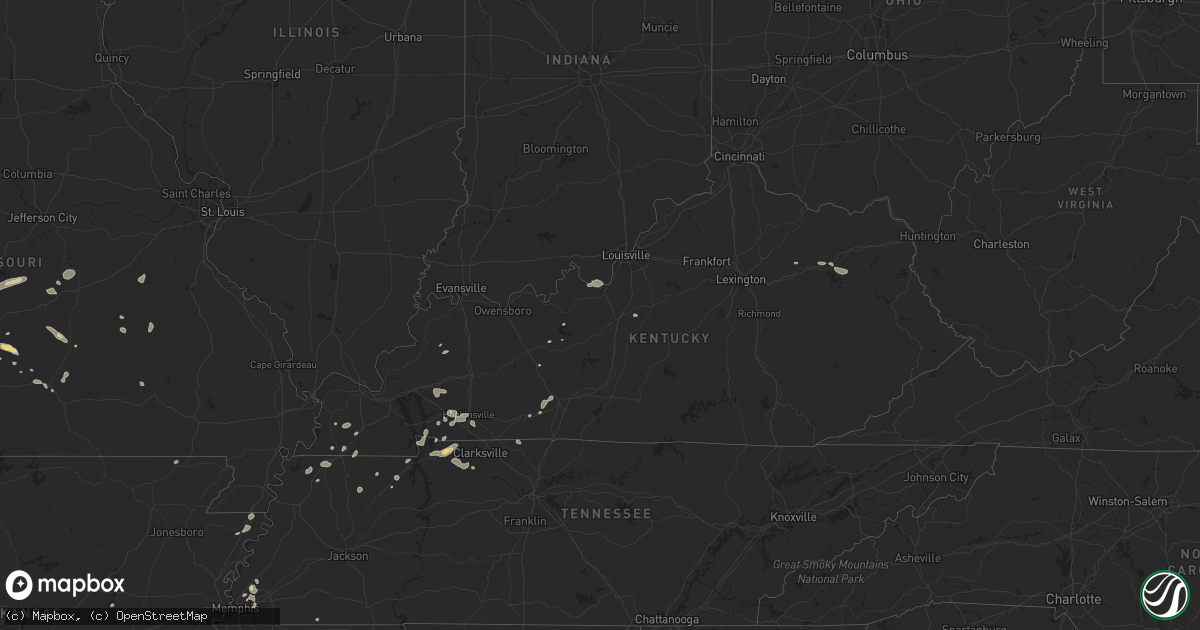
Hail Map in Kentucky on July 4, 2024
Get this storm
July 4 map
$229
one time, instant access
Download today. No call, no setup
Keep the $229
Bought the map and want the full workflow? Apply the entire $229 to a subscription within 7 days. None of it is wasted.
Every map, not just this one
This buys you this map. Subscription and you get every map we run, in the markets you choose from a few cities to whole states to nationwide. Plus real-time alerts the moment a storm fires.
Contact data
Name, contact info, occupancy, even credit band for addresses in the footprint. You go from where it hit to who to call.
Become the source they trust
Unlimited branding weather history reports on demand. You already have the documented answer ready for the property owner, and you are the one who showed up with it.
Property data and RoofTrace estimates
Pull up any address you have got, its value and the exact code rules for that jurisdiction, straight from One Click Code. Then RoofTrace estimates the squares, pitch, and roof value, priced the way you price.
Storm reports in Kentucky
Kentucky
| Date | Description |
|---|---|
| 07/04/20244:48 PM CDT | Power outages. Wind speeds estimated 50 to 60 mph. Time estimated via radar. |
| 07/04/20243:36 PM CDT | Elliott county dispatch reported 1 tree down on ky-556 right outside the sandy hook city limits. Time estimated from radar. |
| 07/04/20243:29 PM CDT | Rowan county dispatch reported a tree blown down and blocking both lanes of ky-172 near the intersection with mcglone-hitch road. Time estimated from radar. |
| 07/04/20243:05 PM CDT | Rowan county dispatch reported a tree down on internet cables at the intersection of knapp ave and cecil drive. Time estimated from radar. |
| 07/04/202412:27 PM CDT | Nws storm survey found a brief ef-1 tornado touched down and lasted about a half mile on the ground as it traveled east and east southeast. The tornado was wide at onse |
| 07/04/202412:26 PM CDT | Trees down and power poles snapped. |
| 07/04/20244:49 AM CDT | A local report indicates 70 MPH wind near 4 ENE Cadiz |
All States Impacted by Hail Map on July 4, 2024
Cities Impacted by Hail Map on July 4, 2024
- Penokee, KS
- Hill City, KS
- Bogue, KS
- Palco, KS
- Damar, KS
- Plainville, KS
- Stockton, KS
- Ellis, KS
- Hays, KS
- Catharine, KS
- Gorham, KS
- Natoma, KS
- Paradise, KS
- Victoria, KS
- Russell, KS
- Walker, KS
- Luray, KS
- Bunker Hill, KS
- Waldo, KS
- Sylvan Grove, KS
- Dorrance, KS
- Lucas, KS
- Wilson, KS
- Lorraine, KS
- Lincoln, KS
- Ellsworth, KS
- Kanopolis, KS
- Beverly, KS
- Minneapolis, KS
- Brookville, KS
- Tescott, KS
- Salina, KS
- New Cambria, KS
- Solomon, KS
- Bennington, KS
- Abilene, KS
- Assaria, KS
- Gypsum, KS
- Lindsborg, KS
- Claflin, KS
- Hoisington, KS
- Holyrood, KS
- Halstead, KS
- Tampa, KS
- Sterling, KS
- Hutchinson, KS
- Ellinwood, KS
- Galva, KS
- Marquette, KS
- Hillsboro, KS
- Roxbury, KS
- Burrton, KS
- Canton, KS
- Nickerson, KS
- Moundridge, KS
- Bushton, KS
- Buhler, KS
- Windom, KS
- Alden, KS
- Lyons, KS
- Falun, KS
- Little River, KS
- Inman, KS
- Goessel, KS
- North Newton, KS
- Raymond, KS
- Newton, KS
- Chase, KS
- Geneseo, KS
- Lehigh, KS
- Hesston, KS
- Mcpherson, KS
- Durham, KS
- Bentley, KS
- Mount Hope, KS
- South Hutchinson, KS
- Valley Center, KS
- Sedgwick, KS
- Olmitz, KS
- Pfeifer, KS
- Otis, KS
- Longford, KS
- Barnard, KS
- Clay Center, KS
- Talmage, KS
- Whitewater, KS
- El Dorado, KS
- Walton, KS
- Atlanta, KS
- Burns, KS
- Andover, KS
- Marion, KS
- Potwin, KS
- Latham, KS
- Benton, KS
- Peabody, KS
- Leon, KS
- Greenwich, KS
- Kechi, KS
- Towanda, KS
- Wichita, KS
- Elbing, KS
- Augusta, KS
- Florence, KS
- Lincolnville, KS
- Hope, KS
- Ramona, KS
- Cassoday, KS
- Herington, KS
- Lost Springs, KS
- Chapman, KS
- Cedar Point, KS
- Enterprise, KS
- Burdick, KS
- Rosalia, KS
- Wakefield, KS
- Woodbine, KS
- Haven, KS
- Abbyville, KS
- Partridge, KS
- Arlington, KS
- Pretty Prairie, KS
- Junction City, KS
- Milford, KS
- Flandreau, SD
- Elkton, SD
- Ferdinand, IN
- Dale, IN
- Huntingburg, IN
- Tyler, MN
- Lynd, MN
- Russell, MN
- Lake Wilson, MN
- Ruthton, MN
- Lismore, MN
- Wilmont, MN
- Chandler, MN
- Balaton, MN
- Slayton, MN
- Garvin, MN
- Marshall, MN
- Iona, MN
- Corydon, IN
- Lanesville, IN
- Laconia, IN
- Brandenburg, KY
- Elizabeth, IN
- Hardinsburg, KY
- McDaniels, KY
- Cylinder, IA
- Leitchfield, KY
- Fulda, MN
- Lake Park, IA
- Caneyville, KY
- Falls Of Rough, KY
- Hurdsfield, ND
- New Haven, KY
- Elizabethtown, KY
- Boston, KY
- Fort Davis, TX
- Success, AR
- Lakota, ND
- Anadarko, OK
- Spirit Lake, IA
- Morgantown, KY
- Everly, IA
- Hartley, IA
- White Earth, ND
- Harris, IA
- Terril, IA
- Causey, NM
- Horse Branch, KY
- Sharpsburg, KY
- Titonka, IA
- Crookston, MN
- Estherville, IA
- Michigan, ND
- Salt Lick, KY
- Morehead, KY
- Graettinger, IA
- Pekin, ND
- Clearfield, KY
- Adams, ND
- Wallingford, IA
- Ringsted, IA
- Clay, KY
- Providence, KY
- Armstrong, IA
- Marathon, TX
- Dixon, KY
- Emmetsburg, IA
- West Liberty, KY
- Petersburg, ND
- Binford, ND
- Blanchard, OK
- Bancroft, IA
- Lawton, ND
- Maple, TX
- Fort Stockton, TX
- Sudan, TX
- Butler, OK
- Edmore, ND
- Rogers, NM
- Swea City, IA
- Burt, IA
- Princeton, KY
- Dawson Springs, KY
- Ninnekah, OK
- Lu Verne, IA
- Morton, TX
- Algona, IA
- Livermore, IA
- Bode, IA
- Cadiz, KY
- Milnesand, NM
- Mountain Grove, MO
- Pine Island, MN
- Carter, OK
- Noble, OK
- Wanette, OK
- Lexington, OK
- Macomb, OK
- Canute, OK
- Elida, NM
- Roswell, NM
- Hardy, IA
- Renwick, IA
- Corwith, IA
- Hopkinsville, KY
- Pep, NM
- Garner, IA
- Rush Springs, OK
- Gracey, KY
- Lindsay, OK
- Maysville, OK
- Purcell, OK
- Willow, OK
- Lovington, NM
- Whiteface, TX
- Goldfield, IA
- El Reno, OK
- Yukon, OK
- Kanawha, IA
- Pembroke, KY
- Chandler, OK
- Ventura, IA
- Wellston, OK
- Lockney, TX
- Tatum, NM
- Mcdonald, NM
- Cabool, MO
- Levelland, TX
- Sayre, OK
- Wayne, OK
- Calumet, OK
- Floydada, TX
- Luther, OK
- Oklahoma City, OK
- Clear Lake, IA
- Paoli, OK
- Stratford, OK
- Bradley, OK
- Turkey, TX
- Indian Mound, TN
- Bethany, OK
- Hobbs, NM
- Stroud, OK
- Grand Junction, TN
- Sapulpa, OK
- Byars, OK
- Mason City, IA
- Beggs, OK
- Mounds, OK
- Rockwell, IA
- Sheffield, IA
- Palmyra, TN
- Cumberland City, TN
- Eagle Butte, SD
- Gotebo, OK
- Ada, OK
- Brownfield, TX
- Denver City, TX
- Dougherty, IA
- Plains, TX
- Blairsburg, IA
- Mustang, OK
- Seminole, TX
- Cunningham, TN
- Seagraves, TX
- Hanna, OK
- Webster City, IA
- Kiefer, OK
- Glenpool, OK
- Jones, OK
- Springfield, TN
- Wann, OK
- Dewey, OK
- Ropesville, TX
- Lubbock, TX
- Wolfforth, TX
- Smyer, TX
- Shallowater, TX
- Eufaula, OK
- Jal, NM
- Hollis, OK
- Paris, TN
- Williams, IA
- Mountain View, OK
- Lone Wolf, OK
- Arcadia, OK
- Buchanan, TN
- Bixby, OK
- Alden, IA
- Allen, OK
- Tupelo, OK
- Stonewall, OK
- Agra, OK
- Carnegie, OK
- Delaware, OK
- Lenapah, OK
- Saint James, MN
- Butterfield, MN
- Cushing, OK
- Meadow, TX
- Ormsby, MN
- Gravette, AR
- Sulphur Springs, AR
- Vinson, OK
- Guthrie, OK
- Chouteau, OK
- Okmulgee, OK
- Noel, MO
- Cazenovia, WI
- Harrah, OK
- Apache, OK
- Meridian, OK
- Pineville, MO
- Nowata, OK
- Wagoner, OK
- Truman, MN
- Slaton, TX
- Tokio, TX
- Mangum, OK
- Locust Grove, OK
- Bristow, OK
- Lawton, OK
- Medicine Park, OK
- Elgin, OK
- Fort Sill, OK
- Chaseburg, WI
- Stoddard, WI
- Salina, OK
- La Valle, WI
- Reedsburg, WI
- Morris, OK
- Carney, OK
- Bartlesville, OK
- Fletcher, OK
- Decatur, AR
- Powell, MO
- S Coffeyville, OK
- Coon Valley, WI
- Rose, OK
- Cassville, MO
- Perkins, OK
- Stillwater, OK
- Ransom Canyon, TX
- Childress, TX
- Cyril, OK
- Edna, KS
- Coffeyville, KS
- Idalou, TX
- Washburn, MO
- Inola, OK
- Ripley, OK
- Mcalester, OK
- Indianola, OK
- Rocky Comfort, MO
- Tryon, OK
- Geronimo, OK
- Walters, OK
- Duncan, OK
- Marlow, OK
- Eucha, OK
- Colcord, OK
- West Point, KY
- Clarksville, TN
- Bentonville, AR
- Exeter, MO
- Pryor, OK
- Lorenzo, TX
- Jay, OK
- Gentry, AR
- Fairview, MO
- Purdy, MO
- Wheaton, MO
- Broken Arrow, OK
- Springdale, AR
- Centerton, AR
- Bartlett, KS
- Adair, OK
- Grove, OK
- Oswego, KS
- Altamont, KS
- Cave Springs, AR
- Headrick, OK
- Monett, MO
- Jennings, OK
- Spavinaw, OK
- Alex, OK
- Lowell, AR
- Fayetteville, AR
- Parsons, KS
- Mount Vernon, MO
- Verona, MO
- Tulsa, OK
- Anderson, MO
- Stella, MO
- McCune, KS
- Peggs, OK
- Raton, NM
- Sand Springs, OK
- Jenks, OK
- Goodman, MO
- Neosho, MO
- Vernon, TX
- Crane, MO
- Aurora, MO
- Marionville, MO
- Billings, MO
- Pierce City, MO
- Elmore City, OK
- Pauls Valley, OK
- Clever, MO
- Stark City, MO
- Niangua, MO
- Conway, MO
- Grovespring, MO
- Republic, MO
- Liberal, MO
- Lamar, MO
- Wentworth, MO
- Ozark, MO
- Ash Grove, MO
- Everton, MO
- South Greenfield, MO
- Big Cabin, OK
- Lebanon, MO
- Nixa, MO
- Brookline, MO
- Springfield, MO
- Rogersville, MO
- Trinidad, CO
- Stockton, MO
- Sarcoxie, MO
- Reeds, MO
- Sparta, MO
- Stotts City, MO
- Walnut Grove, MO
- Hartville, MO
- Bois D Arc, MO
- Vinita, OK
- Fair Play, MO
- Omaha, AR
- Falcon, MO
- La Russell, MO
- Dunnegan, MO
- Fordland, MO
- Bruner, MO
- Seymour, MO
- Morrisville, MO
- Willard, MO
- Miller, MO
- Evansville, AR
- Stilwell, OK
- Bolivar, MO
- Humansville, MO
- Flemington, MO
- Dixon, MO
- Pittsburg, MO
- Polk, MO
- Waynesville, MO
- Laquey, MO
- Natural Dam, AR
- Canehill, AR
- Newburg, MO
- Plato, MO
- Fort Leonard Wood, MO
- Hermitage, MO
- Houston, MO
- Elk Creek, MO
- Long Lane, MO
- Marshfield, MO
- Elkland, MO
- Licking, MO
- Duke, MO
- Camdenton, MO
- Macks Creek, MO
- Boss, MO
- Randlett, OK
- Wichita Falls, TX
- Montreal, MO
- Bunker, MO
- Cherryville, MO
- Santa Rosa, NM
- Petrolia, TX
- Richland, MO
- Brumley, MO
- Linn Creek, MO
- Iberia, MO
- Crocker, MO
- Cuervo, NM
- Byers, TX
- Vichy, MO
- Rolla, MO
- Waurika, OK
- Ryan, OK
- Belleview, MO
- Bixby, MO
- Black, MO
- Vienna, MO
- Claremore, OK
- Bourbon, MO
- Sweetwater, OK
- Conchas Dam, NM
- Trementina, NM
- Catoosa, OK
- Las Vegas, NM
- Garita, NM
- Tucumcari, NM
- Briscoe, TX
- Wheeler, TX
- Hulbert, OK
- Mosquero, NM
- Erick, OK
- Logan, NM
- Vega, TX
- Elk City, OK
- Panhandle, TX
- Union City, TN
- Siloam Springs, AR
- Mcalister, NM
- Melrose, NM
- Rives, TN
- Winona, MO
- Fulton, KY
- Water Valley, KY
- Dukedom, TN
- Luxora, AR
- Blytheville, AR
- Hillpoint, WI
- Pampa, TX
- Obion, TN
- Troy, TN
- Hornbeak, TN
- Mayfield, KY
- Fancy Farm, KY
- Nara Visa, NM
- Wingo, KY
- Arlington, KY
- Augusta, AR
- Hobart, OK
- Murphysboro, IL
- Dover, TN
- Cottage Grove, TN
- Gleason, TN
- Herndon, KY
- Bumpus Mills, TN
- Millington, TN
- Atoka, TN
- Memphis, TN
- Arlington, TN
- Big Rock, TN
- Cordova, TN
- Cement, OK
- Auburn, KY
- Russellville, KY
- Rockfield, KY
- Bowling Green, KY
- Saltillo, MS
- Tupelo, MS
- Temple, OK
- Faxon, OK
- Comanche, OK
- Louisville, KY


