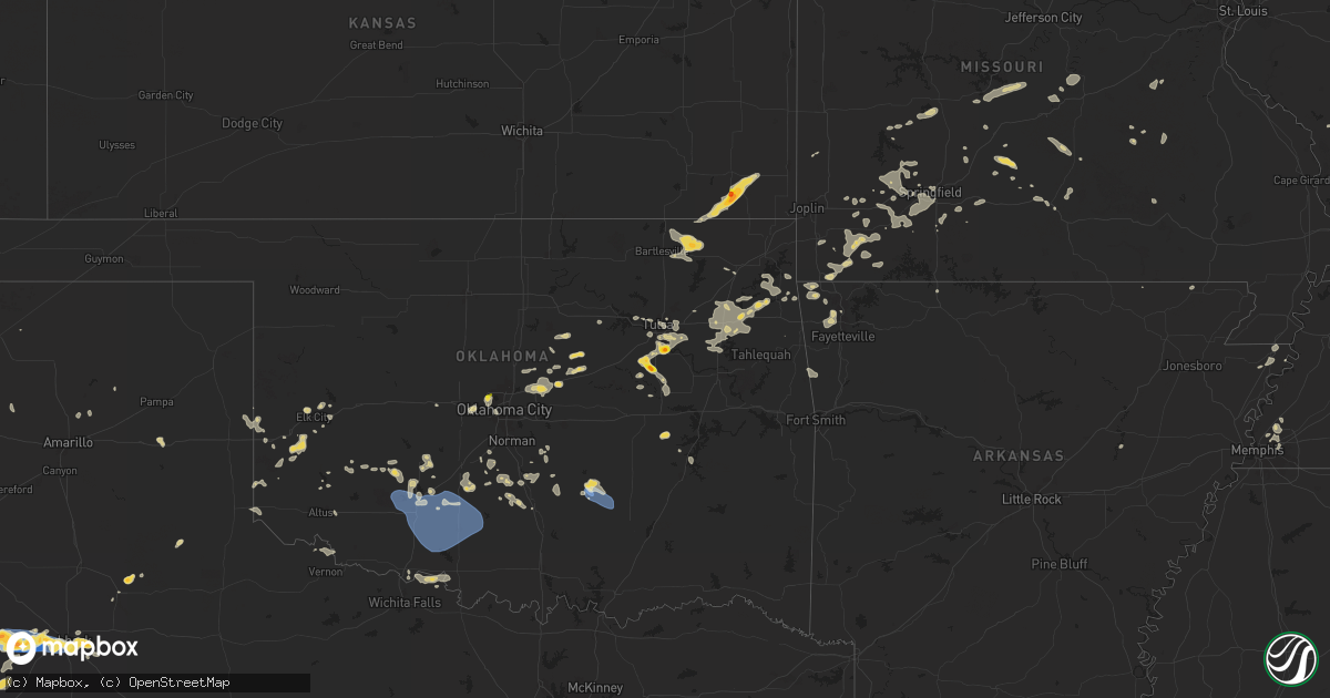
Hail Map on July 4, 2024
Get this storm
July 4 map
$229
one time, instant access
Download today. No call, no setup
Keep the $229
Bought the map and want the full workflow? Apply the entire $229 to a subscription within 7 days. None of it is wasted.
Every map, not just this one
This buys you this map. Subscription and you get every map we run, in the markets you choose from a few cities to whole states to nationwide. Plus real-time alerts the moment a storm fires.
Contact data
Name, contact info, occupancy, even credit band for addresses in the footprint. You go from where it hit to who to call.
Become the source they trust
Unlimited branding weather history reports on demand. You already have the documented answer ready for the property owner, and you are the one who showed up with it.
Property data and RoofTrace estimates
Pull up any address you have got, its value and the exact code rules for that jurisdiction, straight from One Click Code. Then RoofTrace estimates the squares, pitch, and roof value, priced the way you price.
States Impacted by Hail Map on July 4, 2024
Storm reports
Virginia
| Date | Description |
|---|---|
| 07/04/20246:25 PM CDT | Tree down across the road. Time estimated from radar. |
| 07/04/20246:05 PM CDT | Tree down across roadway. Time estimated from radar. |
| 07/04/20245:49 PM CDT | Tree down... Time estimated from radar. |
| 07/04/20245:36 PM CDT | Tree down on road. Time estimated from radar. |
| 07/04/20245:22 PM CDT | Trees blew down onto power lines in the 500 block of va-608 battlefield road. |
| 07/04/20245:21 PM CDT | Trees blew down in the 600 block of keezletown road. |
| 07/04/20245:10 PM CDT | A tree was blown down by thunderstorm winds near the intersection of greensboro road and old sand road. |
| 07/04/20245:05 PM CDT | A wind gust of 52 knots |
| 07/04/20245:00 PM CDT | Two trees were blown down by thunderstorm winds across horsepasture price road. |
| 07/04/20245:00 PM CDT | Tree down at the intersection of claudville hwy and dan valley farm rd. |
| 07/04/20244:45 PM CDT | Several reports of trees down in the laurel fork area and near the blue ridge parkway. |
| 07/04/20243:05 PM CDT | A large tree was blown down by thunderstorm winds just off of w. Main street. |
| 07/04/20242:59 PM CDT | Tree down across road. Outflow ahead of thunderstorm. |
Kansas
| Date | Description |
|---|---|
| 07/03/20248:20 PM CDT | A local report indicates 1.75 inch wind near 1 E Altamont |
Indiana
| Date | Description |
|---|---|
| 07/04/202412:05 PM CDT | A brief ef-0 tornado touched down along highway 135 between sky aire road and highway 335. The tornado damaged trees and minor structures there... Before continuing ese |
| 07/04/202412:03 PM CDT | Trees down on a house. |
New Mexico
| Date | Description |
|---|---|
| 07/04/20245:55 PM CDT | A local report indicates 76 MPH wind near 17 NW Jal |
| 07/04/20244:01 PM CDT | [landspout] |
| 07/03/20248:55 PM CDT | A local report indicates 1.50 inch wind near 5 S Raton |
North Carolina
| Date | Description |
|---|---|
| 07/04/20245:26 PM CDT | 7 reports of trees down across the county. First report in westfield near stokes-surry county line. Last report was in pine hall before the storms exited the county bet |
| 07/04/20245:15 PM CDT | A tree was blown down onto a power line by thunderstorm winds just off of village main trail. |
| 07/04/20245:06 PM CDT | Power lines down. Time based on radar. |
| 07/04/20244:36 PM CDT | Power line down on road. Time based on when radar showed gust front came through. |
Illinois
| Date | Description |
|---|---|
| 07/04/20241:39 PM CDT | [landspout] video and photos from em indicating a landsp |
| 07/04/20241:39 PM CDT | [landspout] video and photos from em indicating a landspout developed near e 900n between n 1200 e and n 1300e. It was intermittently in contact with the ground before |
| 07/04/20243:57 AM CDT | Several large branches down along with 2 big trees. Delayed report. |
| 07/04/20243:42 AM CDT | Multiple trees and powerlines down in murphysboro. Jackson so dealing with numerous trees down across roads. |
Ohio
| Date | Description |
|---|---|
| 07/03/20248:52 PM CDT | Large branches down. Time estimated from radar. |
| 07/03/20248:35 PM CDT | Multiple trees blown down. Time estimated from radar data. |
| 07/03/20247:46 PM CDT | Tree damage. Possible weak tornado. |
| 07/03/20247:44 PM CDT | Brief ef0 tornado confirmed via video. Estimated wind speed of 65 mph from minor tree damage and thrown patio furniture. 0.17 mile track length. |
Kentucky
| Date | Description |
|---|---|
| 07/04/20244:48 PM CDT | Power outages. Wind speeds estimated 50 to 60 mph. Time estimated via radar. |
| 07/04/20243:36 PM CDT | Elliott county dispatch reported 1 tree down on ky-556 right outside the sandy hook city limits. Time estimated from radar. |
| 07/04/20243:29 PM CDT | Rowan county dispatch reported a tree blown down and blocking both lanes of ky-172 near the intersection with mcglone-hitch road. Time estimated from radar. |
| 07/04/20243:05 PM CDT | Rowan county dispatch reported a tree down on internet cables at the intersection of knapp ave and cecil drive. Time estimated from radar. |
| 07/04/202412:27 PM CDT | Nws storm survey found a brief ef-1 tornado touched down and lasted about a half mile on the ground as it traveled east and east southeast. The tornado was wide at onse |
| 07/04/202412:26 PM CDT | Trees down and power poles snapped. |
| 07/04/20244:49 AM CDT | A local report indicates 70 MPH wind near 4 ENE Cadiz |
Texas
| Date | Description |
|---|---|
| 07/04/20246:19 PM CDT | Report from mping: 1-inch tree limbs broken; shingles blown off. |
| 07/04/20246:16 PM CDT | [landspout] photo of landspout sent in via social media. |
| 07/04/20246:14 PM CDT | A local report indicates 60 MPH wind near 5 S Wolfforth |
| 07/04/20245:57 PM CDT | Estimated peak wind gusts of 80+ mph. Lots of thick blowing dust too. |
| 07/04/20245:38 PM CDT | The west texas mesonet measured numerous gusts of 58+ mph from 5:24 pm to 5:48 pm... With a peak gust of 80 mph at 5:38 pm. |
| 07/04/20245:02 PM CDT | Measured by the west texas mesonet. Several wind gusts of 58+ mph occurred from 5:01 pm to 5:10 pm. |
| 07/04/20245:02 PM CDT | Corrects previous tstm wnd gst report from 8 sw sundown. Measured by the west texas mesonet. Several wind gusts of 58+ mph occurred from 5:01 pm to 5:11 pm. |
| 07/04/20242:44 PM CDT | A local report indicates 58 MPH wind near 9 E Kent |
| 07/03/20248:05 PM CDT | A local report indicates 61 MPH wind near 5 NE Odessa |
Missouri
| Date | Description |
|---|---|
| 07/04/20242:48 AM CDT | Large tree limb down on garage with extensive damage. |
| 07/04/20242:29 AM CDT | A 10 to 15 inch in diameter tree downed in the area of 2 high downs lane. |
| 07/04/20242:27 AM CDT | Traffic lights out due to power outage. |
| 07/04/20242:25 AM CDT | One power line knocked down in the 20 block of clayton terrace. |
| 07/04/20242:25 AM CDT | One tree down. Officer reports a full grown tree... But size unknown. 100 block of frontenac forest street. |
| 07/04/20242:24 AM CDT | Corrects previous tstm wnd dmg report from 6 n zalma. Couple of trees down in the county. |
| 07/04/20242:12 AM CDT | Corrects previous tstm wnd dmg report from 3 nnw poplar bluff. Tree down at hwy w and ridge hill ln. Time estimated from radar. |
| 07/04/20241:50 AM CDT | Trees down at sam baker state park.3...000+ without power in wayne county. |
| 07/04/20241:40 AM CDT | A couple of trees down in piedmont. |
| 07/04/20241:23 AM CDT | Couple of trees down in the county. |
| 07/04/20241:14 AM CDT | Corrects previous tstm wnd dmg report from 3 nnw poplar bluff. Tree down at hwy w and ridge hill ln. Time estimated from radar. |
| 07/04/202412:19 AM CDT | Delayed report... Time estimated from radar. Multiple large trees blown down across highway 19 and kk. Loss of electricity across akers and timber area for over 12 hour |
| 07/04/202412:18 AM CDT | Delayed report... Time estimated by radar. Several trees and limbs down in pulltite campground and along ee highway. Photos sent via email. |
| 07/04/202412:14 AM CDT | Tree down at hwy w and ridge hill ln. Time estimated from radar. |
| 07/03/202411:45 PM CDT | Delayed report... Time estimated from radar. Tree uprooted... And large tree limbs damaged. |
| 07/03/202411:42 PM CDT | Delayed report... Time estimated from radar. Partner report of howell-oregon electric coop power outage for 700 members... Majority in dora area. Winds pushed trees thr |
| 07/03/202411:33 PM CDT | Delayed report... Time estimated from radar. Three pine trees blown over... Big oak tree down... Several larger branches broken at the old junior high school. A large b |
| 07/03/202411:32 PM CDT | Delayed report. Multiple large tree branches down across town. Power outages reported as well. |
| 07/03/202411:08 PM CDT | Delayed report... Time indicated by radar. Dense side of large tree snapped from trunk... With many other smaller branches broken and strewn about. Photos via email. |
| 07/03/202410:05 PM CDT | Delayed mping report with time estimated by radar. 3 inch tree limbs and power poles broken. Downburst signature evident on radar. |
| 07/03/202410:00 PM CDT | Report from mping. Trees uprooted or snapped. Roof blown off. |
| 07/03/202410:00 PM CDT | Estimated 70 mph winds reported. Power outages over 3000 in christian county. |
| 07/03/20249:53 PM CDT | Report from mping: 1-inch tree limbs broken; shingles blown off. |
| 07/03/20249:52 PM CDT | Report from mping: 1-inch tree limbs broken; shingles blown off. |
| 07/03/20249:50 PM CDT | 2 inch limbs down in nixa. Also over 1000 homes without power in christian county. |
| 07/03/20249:43 PM CDT | Multiple large 1 to 3 inch tree limbs were reported down via mping. A few shingles were blown of a roof. |
| 07/03/20249:43 PM CDT | Tree blocking road near east elementary with many smaller tree branches damaged and snapped. |
| 07/03/20249:35 PM CDT | A large tree was uprooted and numerous branches were reported down by high winds. |
| 07/03/20249:31 PM CDT | Delayed report. Time estimated by radar. Multiple trees and power lines down. |
| 07/03/20249:25 PM CDT | Power lines down in clever. |
| 07/03/20249:15 PM CDT | Tree down on a home. |
| 07/03/20248:02 PM CDT | Quarter inch hail mping report from public. |
Oklahoma
| Date | Description |
|---|---|
| 07/04/20246:55 PM CDT | Medicine park mesonet. |
| 07/04/20246:25 PM CDT | Report from mping: quarter |
| 07/04/20246:23 PM CDT | A local report indicates 1.50 inch wind near 2 WNW Bixby |
| 07/04/20246:23 PM CDT | Report from mping: quarter |
| 07/04/20246:12 PM CDT | A local report indicates 1.50 inch wind near 3 NNE Beggs |
| 07/04/20246:05 PM CDT | Large trees in the roadway near the intersection of covell road and luther road. Additional trees with large limbs down. Radar estimated time. |
| 07/04/20245:55 PM CDT | Multiple confirmations of large tree limbs down across the city of ada. Radar estimated time. |
| 07/04/20245:55 PM CDT | Social media image showing vinyl siding of a large retail store peeled back. Radar estimated time. |
| 07/04/20245:55 PM CDT | Ada mesonet. |
| 07/04/20245:53 PM CDT | Corrects previous tstm wnd gst report from 2 nnw ada. Ada municipal airport. |
| 07/04/20245:50 PM CDT | Relayed report of power lines down. Estimated time. |
| 07/04/20245:50 PM CDT | Ada municipal airport. |
| 07/04/20245:49 PM CDT | Measured with handheld anemometer. |
| 07/04/20245:11 PM CDT | Phone call report. |
| 07/04/20245:08 PM CDT | Image shared via social media. |
| 07/04/20245:07 PM CDT | Report from mping: quarter |
| 07/03/20248:35 PM CDT | 4 or 5 power poles down. |
| 07/03/20248:30 PM CDT | Ketchum ranch mesonet. |
| 07/03/20248:12 PM CDT | Duncan halliburton field airport |
| 07/03/20247:57 PM CDT | Personal weather station. |
| 07/03/20247:40 PM CDT | Walters mesonet. |
| 07/03/20247:32 PM CDT | Lawton-fort sill regional airport |
| 07/03/20247:29 PM CDT | Fort sill |
| 07/03/20247:17 PM CDT | Large tree limb down. Spotter network report. |
| 07/03/20247:03 PM CDT | Measured by davis weather station. |
| 07/03/20247:00 PM CDT | Medicine park mesonet. |
Iowa
| Date | Description |
|---|---|
| 07/04/20245:00 PM CDT | Boat dock... Tree... And garage door damage around clear lake. Delayed report. Time estimated by radar. |
| 07/04/20244:40 PM CDT | Delayed report... Time estimated by radar. Large limbs approx 6-8 inches in diameter down on a home and power lines in ventura. |
| 07/04/20241:38 PM CDT | Social media report of quarter sized hail in lake park. |
| 07/04/20241:23 PM CDT | Report via social media. |
Tennessee
| Date | Description |
|---|---|
| 07/04/20246:07 PM CDT | Tspotter estimated 55 to 60 mph winds in springfield tn. |
North Dakota
| Date | Description |
|---|---|
| 07/04/202412:12 PM CDT | Broadcast media relayed a photo of a brief landspout tornado taken from 5 miles south of chaseley and 3 miles east of silver lake. |
Cities Impacted by Hail Map on July 4, 2024
- Penokee, KS
- Hill City, KS
- Bogue, KS
- Palco, KS
- Damar, KS
- Plainville, KS
- Stockton, KS
- Ellis, KS
- Hays, KS
- Catharine, KS
- Gorham, KS
- Natoma, KS
- Paradise, KS
- Victoria, KS
- Russell, KS
- Walker, KS
- Luray, KS
- Bunker Hill, KS
- Waldo, KS
- Sylvan Grove, KS
- Dorrance, KS
- Lucas, KS
- Wilson, KS
- Lorraine, KS
- Lincoln, KS
- Ellsworth, KS
- Kanopolis, KS
- Beverly, KS
- Minneapolis, KS
- Brookville, KS
- Tescott, KS
- Salina, KS
- New Cambria, KS
- Solomon, KS
- Bennington, KS
- Abilene, KS
- Assaria, KS
- Gypsum, KS
- Lindsborg, KS
- Claflin, KS
- Hoisington, KS
- Holyrood, KS
- Halstead, KS
- Tampa, KS
- Sterling, KS
- Hutchinson, KS
- Ellinwood, KS
- Galva, KS
- Marquette, KS
- Hillsboro, KS
- Roxbury, KS
- Burrton, KS
- Canton, KS
- Nickerson, KS
- Moundridge, KS
- Bushton, KS
- Buhler, KS
- Windom, KS
- Alden, KS
- Lyons, KS
- Falun, KS
- Little River, KS
- Inman, KS
- Goessel, KS
- North Newton, KS
- Raymond, KS
- Newton, KS
- Chase, KS
- Geneseo, KS
- Lehigh, KS
- Hesston, KS
- Mcpherson, KS
- Durham, KS
- Bentley, KS
- Mount Hope, KS
- South Hutchinson, KS
- Valley Center, KS
- Sedgwick, KS
- Olmitz, KS
- Pfeifer, KS
- Otis, KS
- Longford, KS
- Barnard, KS
- Clay Center, KS
- Talmage, KS
- Whitewater, KS
- El Dorado, KS
- Walton, KS
- Atlanta, KS
- Burns, KS
- Andover, KS
- Marion, KS
- Potwin, KS
- Latham, KS
- Benton, KS
- Peabody, KS
- Leon, KS
- Greenwich, KS
- Kechi, KS
- Towanda, KS
- Wichita, KS
- Elbing, KS
- Augusta, KS
- Florence, KS
- Lincolnville, KS
- Hope, KS
- Ramona, KS
- Cassoday, KS
- Herington, KS
- Lost Springs, KS
- Chapman, KS
- Cedar Point, KS
- Enterprise, KS
- Burdick, KS
- Rosalia, KS
- Wakefield, KS
- Woodbine, KS
- Haven, KS
- Abbyville, KS
- Partridge, KS
- Arlington, KS
- Pretty Prairie, KS
- Junction City, KS
- Milford, KS
- Flandreau, SD
- Elkton, SD
- Ferdinand, IN
- Dale, IN
- Huntingburg, IN
- Tyler, MN
- Lynd, MN
- Russell, MN
- Lake Wilson, MN
- Ruthton, MN
- Lismore, MN
- Wilmont, MN
- Chandler, MN
- Balaton, MN
- Slayton, MN
- Garvin, MN
- Marshall, MN
- Iona, MN
- Corydon, IN
- Lanesville, IN
- Laconia, IN
- Brandenburg, KY
- Elizabeth, IN
- Hardinsburg, KY
- McDaniels, KY
- Cylinder, IA
- Leitchfield, KY
- Fulda, MN
- Lake Park, IA
- Caneyville, KY
- Falls Of Rough, KY
- Hurdsfield, ND
- New Haven, KY
- Elizabethtown, KY
- Boston, KY
- Fort Davis, TX
- Success, AR
- Lakota, ND
- Anadarko, OK
- Spirit Lake, IA
- Morgantown, KY
- Everly, IA
- Hartley, IA
- White Earth, ND
- Harris, IA
- Terril, IA
- Causey, NM
- Horse Branch, KY
- Sharpsburg, KY
- Titonka, IA
- Crookston, MN
- Estherville, IA
- Michigan, ND
- Salt Lick, KY
- Morehead, KY
- Graettinger, IA
- Pekin, ND
- Clearfield, KY
- Adams, ND
- Wallingford, IA
- Ringsted, IA
- Clay, KY
- Providence, KY
- Armstrong, IA
- Marathon, TX
- Dixon, KY
- Emmetsburg, IA
- West Liberty, KY
- Petersburg, ND
- Binford, ND
- Blanchard, OK
- Bancroft, IA
- Lawton, ND
- Maple, TX
- Fort Stockton, TX
- Sudan, TX
- Butler, OK
- Edmore, ND
- Rogers, NM
- Swea City, IA
- Burt, IA
- Princeton, KY
- Dawson Springs, KY
- Ninnekah, OK
- Lu Verne, IA
- Morton, TX
- Algona, IA
- Livermore, IA
- Bode, IA
- Cadiz, KY
- Milnesand, NM
- Mountain Grove, MO
- Pine Island, MN
- Carter, OK
- Noble, OK
- Wanette, OK
- Lexington, OK
- Macomb, OK
- Canute, OK
- Elida, NM
- Roswell, NM
- Hardy, IA
- Renwick, IA
- Corwith, IA
- Hopkinsville, KY
- Pep, NM
- Garner, IA
- Rush Springs, OK
- Gracey, KY
- Lindsay, OK
- Maysville, OK
- Purcell, OK
- Willow, OK
- Lovington, NM
- Whiteface, TX
- Goldfield, IA
- El Reno, OK
- Yukon, OK
- Kanawha, IA
- Pembroke, KY
- Chandler, OK
- Ventura, IA
- Wellston, OK
- Lockney, TX
- Tatum, NM
- Mcdonald, NM
- Cabool, MO
- Levelland, TX
- Sayre, OK
- Wayne, OK
- Calumet, OK
- Floydada, TX
- Luther, OK
- Oklahoma City, OK
- Clear Lake, IA
- Paoli, OK
- Stratford, OK
- Bradley, OK
- Turkey, TX
- Indian Mound, TN
- Bethany, OK
- Hobbs, NM
- Stroud, OK
- Grand Junction, TN
- Sapulpa, OK
- Byars, OK
- Mason City, IA
- Beggs, OK
- Mounds, OK
- Rockwell, IA
- Sheffield, IA
- Palmyra, TN
- Cumberland City, TN
- Eagle Butte, SD
- Gotebo, OK
- Ada, OK
- Brownfield, TX
- Denver City, TX
- Dougherty, IA
- Plains, TX
- Blairsburg, IA
- Mustang, OK
- Seminole, TX
- Cunningham, TN
- Seagraves, TX
- Hanna, OK
- Webster City, IA
- Kiefer, OK
- Glenpool, OK
- Jones, OK
- Springfield, TN
- Wann, OK
- Dewey, OK
- Ropesville, TX
- Lubbock, TX
- Wolfforth, TX
- Smyer, TX
- Shallowater, TX
- Eufaula, OK
- Jal, NM
- Hollis, OK
- Paris, TN
- Williams, IA
- Mountain View, OK
- Lone Wolf, OK
- Arcadia, OK
- Buchanan, TN
- Bixby, OK
- Alden, IA
- Allen, OK
- Tupelo, OK
- Stonewall, OK
- Agra, OK
- Carnegie, OK
- Delaware, OK
- Lenapah, OK
- Saint James, MN
- Butterfield, MN
- Cushing, OK
- Meadow, TX
- Ormsby, MN
- Gravette, AR
- Sulphur Springs, AR
- Vinson, OK
- Guthrie, OK
- Chouteau, OK
- Okmulgee, OK
- Noel, MO
- Cazenovia, WI
- Harrah, OK
- Apache, OK
- Meridian, OK
- Pineville, MO
- Nowata, OK
- Wagoner, OK
- Truman, MN
- Slaton, TX
- Tokio, TX
- Mangum, OK
- Locust Grove, OK
- Bristow, OK
- Lawton, OK
- Medicine Park, OK
- Elgin, OK
- Fort Sill, OK
- Chaseburg, WI
- Stoddard, WI
- Salina, OK
- La Valle, WI
- Reedsburg, WI
- Morris, OK
- Carney, OK
- Bartlesville, OK
- Fletcher, OK
- Decatur, AR
- Powell, MO
- S Coffeyville, OK
- Coon Valley, WI
- Rose, OK
- Cassville, MO
- Perkins, OK
- Stillwater, OK
- Ransom Canyon, TX
- Childress, TX
- Cyril, OK
- Edna, KS
- Coffeyville, KS
- Idalou, TX
- Washburn, MO
- Inola, OK
- Ripley, OK
- Mcalester, OK
- Indianola, OK
- Rocky Comfort, MO
- Tryon, OK
- Geronimo, OK
- Walters, OK
- Duncan, OK
- Marlow, OK
- Eucha, OK
- Colcord, OK
- West Point, KY
- Clarksville, TN
- Bentonville, AR
- Exeter, MO
- Pryor, OK
- Lorenzo, TX
- Jay, OK
- Gentry, AR
- Fairview, MO
- Purdy, MO
- Wheaton, MO
- Broken Arrow, OK
- Springdale, AR
- Centerton, AR
- Bartlett, KS
- Adair, OK
- Grove, OK
- Oswego, KS
- Altamont, KS
- Cave Springs, AR
- Headrick, OK
- Monett, MO
- Jennings, OK
- Spavinaw, OK
- Alex, OK
- Lowell, AR
- Fayetteville, AR
- Parsons, KS
- Mount Vernon, MO
- Verona, MO
- Tulsa, OK
- Anderson, MO
- Stella, MO
- McCune, KS
- Peggs, OK
- Raton, NM
- Sand Springs, OK
- Jenks, OK
- Goodman, MO
- Neosho, MO
- Vernon, TX
- Crane, MO
- Aurora, MO
- Marionville, MO
- Billings, MO
- Pierce City, MO
- Elmore City, OK
- Pauls Valley, OK
- Clever, MO
- Stark City, MO
- Niangua, MO
- Conway, MO
- Grovespring, MO
- Republic, MO
- Liberal, MO
- Lamar, MO
- Wentworth, MO
- Ozark, MO
- Ash Grove, MO
- Everton, MO
- South Greenfield, MO
- Big Cabin, OK
- Lebanon, MO
- Nixa, MO
- Brookline, MO
- Springfield, MO
- Rogersville, MO
- Trinidad, CO
- Stockton, MO
- Sarcoxie, MO
- Reeds, MO
- Sparta, MO
- Stotts City, MO
- Walnut Grove, MO
- Hartville, MO
- Bois D Arc, MO
- Vinita, OK
- Fair Play, MO
- Omaha, AR
- Falcon, MO
- La Russell, MO
- Dunnegan, MO
- Fordland, MO
- Bruner, MO
- Seymour, MO
- Morrisville, MO
- Willard, MO
- Miller, MO
- Evansville, AR
- Stilwell, OK
- Bolivar, MO
- Humansville, MO
- Flemington, MO
- Dixon, MO
- Pittsburg, MO
- Polk, MO
- Waynesville, MO
- Laquey, MO
- Natural Dam, AR
- Canehill, AR
- Newburg, MO
- Plato, MO
- Fort Leonard Wood, MO
- Hermitage, MO
- Houston, MO
- Elk Creek, MO
- Long Lane, MO
- Marshfield, MO
- Elkland, MO
- Licking, MO
- Duke, MO
- Camdenton, MO
- Macks Creek, MO
- Boss, MO
- Randlett, OK
- Wichita Falls, TX
- Montreal, MO
- Bunker, MO
- Cherryville, MO
- Santa Rosa, NM
- Petrolia, TX
- Richland, MO
- Brumley, MO
- Linn Creek, MO
- Iberia, MO
- Crocker, MO
- Cuervo, NM
- Byers, TX
- Vichy, MO
- Rolla, MO
- Waurika, OK
- Ryan, OK
- Belleview, MO
- Bixby, MO
- Black, MO
- Vienna, MO
- Claremore, OK
- Bourbon, MO
- Sweetwater, OK
- Conchas Dam, NM
- Trementina, NM
- Catoosa, OK
- Las Vegas, NM
- Garita, NM
- Tucumcari, NM
- Briscoe, TX
- Wheeler, TX
- Hulbert, OK
- Mosquero, NM
- Erick, OK
- Logan, NM
- Vega, TX
- Elk City, OK
- Panhandle, TX
- Union City, TN
- Siloam Springs, AR
- Mcalister, NM
- Melrose, NM
- Rives, TN
- Winona, MO
- Fulton, KY
- Water Valley, KY
- Dukedom, TN
- Luxora, AR
- Blytheville, AR
- Hillpoint, WI
- Pampa, TX
- Obion, TN
- Troy, TN
- Hornbeak, TN
- Mayfield, KY
- Fancy Farm, KY
- Nara Visa, NM
- Wingo, KY
- Arlington, KY
- Augusta, AR
- Hobart, OK
- Murphysboro, IL
- Dover, TN
- Cottage Grove, TN
- Gleason, TN
- Herndon, KY
- Bumpus Mills, TN
- Millington, TN
- Atoka, TN
- Memphis, TN
- Arlington, TN
- Big Rock, TN
- Cordova, TN
- Cement, OK
- Auburn, KY
- Russellville, KY
- Rockfield, KY
- Bowling Green, KY
- Saltillo, MS
- Tupelo, MS
- Temple, OK
- Faxon, OK
- Comanche, OK
- Louisville, KY