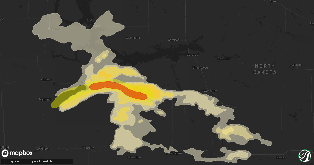
Hail Map in Hazen, ND on July 3, 2016
Get this storm
July 3 map
$229
one time, instant access
Download today. No call, no setup
Keep the $229
Bought the map and want the full workflow? Apply the entire $229 to a subscription within 7 days. None of it is wasted.
Every map, not just this one
This buys you this map. Subscription and you get every map we run, in the markets you choose from a few cities to whole states to nationwide. Plus real-time alerts the moment a storm fires.
Contact data
Name, contact info, occupancy, even credit band for addresses in the footprint. You go from where it hit to who to call.
Become the source they trust
Unlimited branding weather history reports on demand. You already have the documented answer ready for the property owner, and you are the one who showed up with it.
Property data and RoofTrace estimates
Pull up any address you have got, its value and the exact code rules for that jurisdiction, straight from One Click Code. Then RoofTrace estimates the squares, pitch, and roof value, priced the way you price.
Storm reports in Hazen, ND
Hazen, ND
| Date | Description |
|---|---|
| 07/03/20166:50 PM CDT | Numerous reports of tree branches down in hazen. Observation near hazen reported a 72 mph thunderstorm wind gust. |
| 07/03/20166:38 PM CDT | Hazen ndawn observation. |
| 07/03/20166:35 PM CDT | Hail lasted 15 minutes. Largest was golf ball size. |
| 07/03/20166:35 PM CDT | Camper trailer turned over on its side...house siding torn off...and road signs flattened. Time estimated based on radar. |
All States Impacted by Hail Map on July 3, 2016
All Cities Impacted by Hail Map on July 3, 2016
- Stanton, ND
- Zap, ND
- Dodge, ND
- Halliday, ND
- Beulah, ND
- Golden Valley, ND
- Piedmont, SD
- Rapid City, SD
- Black Hawk, SD
- Fordsville, KY
- Boise City, OK
- Alvarado, TX
- Cleburne, TX
- Falls Of Rough, KY
- Leitchfield, KY
- Hartford, KY
- Westview, KY
- Whitesville, KY
- Hardinsburg, KY
- McDaniels, KY
- Utica, KY
- Alvord, TX
- Lexington, OK
- Springfield, CO
- Throckmorton, TX
- Ochelata, OK
- Barnsdall, OK
- Mud Butte, SD
- Newell, SD
- Decatur, TX
- Bridgeport, TX
- Wall, SD
- Bismarck, ND
- Baldwin, ND
- Hazen, ND
- Newcastle, TX
- Roy, NM
- Roseglen, ND
- Woodson, TX
- Norman, OK
- Duncan, OK
- Marlow, OK
- Jacksboro, TX
- Gladstone, ND
- Center, ND
- Taylor, ND
- Wilton, ND
- Washburn, ND
- Hebron, ND
- Glen Ullin, ND
- Dunn Center, ND
- Mingus, TX
- Crossville, TN
- Killdeer, ND
- New Salem, ND
- Watford City, ND
- Ryder, ND
- Keene, ND
- Sterling, ND
- Mandan, ND
- Mandaree, ND
- New Town, ND
- Parshall, ND
- Menoken, ND
- Cresson, TX
- Fort Worth, TX
- Godley, TX
- Weatherford, TX
- Ponder, TX
- Justin, TX
- Portageville, MO
- Bard, NM
- Mosquero, NM
- Friona, TX
- Conchas Dam, NM
- Hereford, TX
- Logan, NM
- Solano, NM
- San Jon, NM
- Dimmitt, TX
- Talala, OK
- Steele, ND
- Driscoll, ND
- New Leipzig, ND
- Nocona, TX
- Henrietta, TX
- Bellevue, TX
- Bowie, TX
- Sunset, TX
- Mounds, OK
- Lead, SD
- Santa Claus, IN
- Bristow, IN
- Saint Meinrad, IN
- Ferdinand, IN
- Aledo, TX
- Joshua, TX
- Crowley, TX
- Keene, TX
- Grandview, TX
- Burleson, TX
- Kenmare, ND
- Bowbells, ND
- Donnybrook, ND
- Pine Ridge, SD
- Wellston, OK
- Luther, OK
- Lindsay, OK
- Rush Springs, OK
- Metropolis, IL
- New Zion, SC
- Gable, SC
- Hardyville, KY
- Center, KY
- Columbia, KY
- Edmonton, KY
- Cave City, KY
- Greensburg, KY
- Horse Cave, KY
- Perrin, TX
- Chelsea, OK
- Bison, SD
- Maxton, NC
- Sturgis, SD
- Tecumseh, OK
- Shawnee, OK
- Oklahoma City, OK
- Choctaw, OK
- Macomb, OK
- Noble, OK
- Newalla, OK
- Meeker, OK
- Mcloud, OK
- Harrah, OK
- Tell City, IN
- Leopold, IN
- Krum, TX
- Denton, TX
- Golconda, IL
- Grantsburg, IL
- Caputa, SD
- Stamford, TX
- Manning, SC
- Kenton, OK
- Felt, OK
- Dalhart, TX
- Grenville, NM
- Kim, CO
- Roanoke, TX
- Argyle, TX
- Byers, TX
- Wichita Falls, TX
- Randlett, OK
- Temple, OK
- Petrolia, TX
- Braddock, ND
- Happy, TX
- Poseyville, IN
- Owanka, SD
- Wasta, SD
- Pauls Valley, OK
- Wounded Knee, SD
- Manderson, SD
- Porcupine, SD
- Hermosa, SD
- Kyle, SD
- Wanblee, SD
- Wing, ND
- Meadow, SD
- Naples, FL
- Seminole, OK
- Wewoka, OK
- Wetumka, OK
- Albany, TX
- Springer, NM
- Ringgold, TX
- Loving, TX
- Bryson, TX
- Graham, TX
- Olney, TX
- Waurika, OK
- Hastings, OK
- Stroud, OK
- Paden, OK
- Martin, SD
- Beaver Dam, KY
- Carson, ND
- Elgin, ND
- Lake Dallas, TX
- Collinsville, TX
- Whitney, TX
- Blum, TX
- Haltom City, TX
- Windthorst, TX
- Purcell, OK
- Adrian, TX
- Vega, TX
- Muenster, TX
- Gainesville, TX
- Oakland, KY
- Smiths Grove, KY
- Chico, TX
- Holliday, TX
- Scotland, TX
- Hay Springs, NE
- Chadron, NE
- Hartsville, SC
- Tulia, TX
- Canyon, TX
- Okemah, OK
- Egnar, CO
- Mayfield, KY
- Fancy Farm, KY
- Garrison, ND
- Mineral Wells, TX
- Crossville, IL
- Griffin, IN
- Carbondale, CO
- Konawa, OK
- Maud, OK
- Marion, KY
- Providence, KY
- Princeton, KY
- Bedford, TX
- Hurst, TX
- Colleyville, TX
- North Richland Hills, TX
- Keller, TX
- Little Elm, TX
- Rhome, TX
- Forestburg, TX
- Paradise, TX
- Jermyn, TX
- Cynthiana, IN
- Wadesville, IN
- Carmi, IL
- Haubstadt, IN
- New Harmony, IN
- Owensville, IN
- Newcastle, OK
- Blanchard, OK
- Valley View, TX
- Sanger, TX
- Pawnee, OK
- Glencoe, OK
- Maramec, OK
- Hawley, TX
- Anson, TX
- Lemmon, SD
- Carney, OK
- Clayton, NM
- Azle, TX
- Rocky Point, NC
- Whitt, TX
- Poolville, TX
- Oelrichs, SD
- Hot Springs, SD
- Hampstead, NC
- Comanche, OK
- Smithwick, SD
- Broken Arrow, OK
- Keystone, SD
- Springtown, TX
- Evanston, IN
- Dale, IN
- Horse Branch, KY
- Olaton, KY
- Wallace, NC
- Asher, OK
- Richardton, ND
- Almont, ND
- Guthrie, OK
- Bessemer City, NC
- Kings Mountain, NC
- Shelby, NC
- Porum, OK
- Stigler, OK
- Whitefield, OK
- Millsap, TX
- Ellenboro, NC
- Vienna, IL
- Silverton, TX
- Box Elder, SD
- Arcadia, FL
- Punta Gorda, FL
- Kellyville, OK
- Sapulpa, OK
- Palo Pinto, TX
- Fort Gibson, OK
- Bristow, OK
- Waxahachie, TX
- Maypearl, TX
- Arlington, TX
- Teachey, NC
- Rose Hill, NC
- The Colony, TX
- Carrollton, TX
- Avoca, TX
- Maysville, OK
- Lipan, TX
- Campo, CO
- Abilene, TX
- Washington, OK
- Glasgow, KY
- Patrick, SC
- Santo, TX
- Clinton, KY
- Clifton, TX
- Holly Ridge, NC
- Tucumcari, NM
- Boyd, TX
- Vinita, OK
- Society Hill, SC
- Darlington, SC
- Evansville, IN
- Graford, TX
- Lake Placid, FL
- Cushing, OK
- Hawesville, KY
- Lewisport, KY
- Pritchett, CO
- Hudson, KY
- Deadwood, SD
- Haskell, TX
- Rushville, NE
- Flower Mound, TX
- Lewisville, TX
- Haslet, TX
- Newark, TX
- Gideon, MO
- Hamlin, TX
- Overbrook, OK
- Lueders, TX
- Bardstown, KY
- Reynolds Station, KY
- Gordon, TX
- Lawndale, NC
- Ramona, OK
- Drumright, OK
- Meridian, OK
- Chandler, OK
- Mission, SD
- Mcalester, OK
- Stillwater, OK
- Yale, OK
- Knob Lick, KY
- Gradyville, KY
- Nemo, TX
- Ada, OK
- Sumter, SC
- Alcolu, SC
- Depew, OK
- Morrison, OK
- Enfield, IL
- Mott, ND
- Napoleon, ND
- Kintyre, ND
- Aubrey, TX
- Pilot Point, TX
- Zolfo Springs, FL
- Arlington, KY
- Elliott, SC
- Bishopville, SC
- Lincoln City, IN
- Huntingburg, IN
- Lamar, IN
- Tennyson, IN
- Holland, IN
- Clay, KY
- Fredonia, KY
- Allen, SD
- Weleetka, OK
- Scenic, SD
- Batesland, SD
- Manning, ND
- Tolley, ND
- Summerfield, TX


