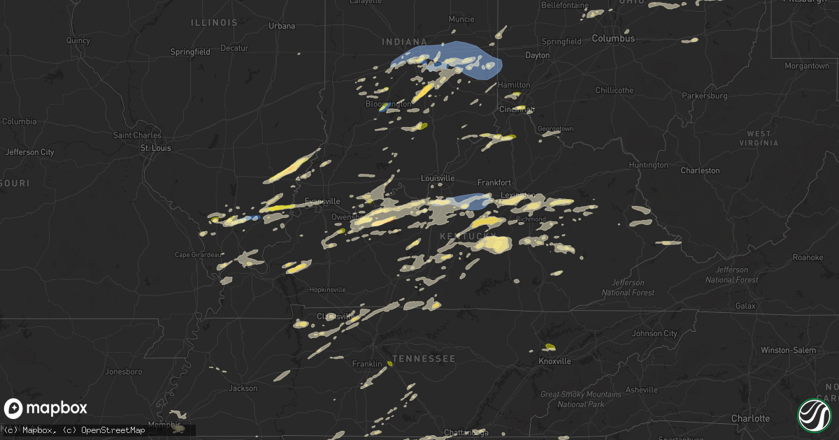
Hail Map in Kentucky on July 2, 2023
Get this storm
July 2 map
$229
one time, instant access
Download today. No call, no setup
Keep the $229
Bought the map and want the full workflow? Apply the entire $229 to a subscription within 7 days. None of it is wasted.
Every map, not just this one
This buys you this map. Subscription and you get every map we run, in the markets you choose from a few cities to whole states to nationwide. Plus real-time alerts the moment a storm fires.
Contact data
Name, contact info, occupancy, even credit band for addresses in the footprint. You go from where it hit to who to call.
Become the source they trust
Unlimited branding weather history reports on demand. You already have the documented answer ready for the property owner, and you are the one who showed up with it.
Property data and RoofTrace estimates
Pull up any address you have got, its value and the exact code rules for that jurisdiction, straight from One Click Code. Then RoofTrace estimates the squares, pitch, and roof value, priced the way you price.
Storm reports in Kentucky
Kentucky
| Date | Description |
|---|---|
| 07/02/20236:56 PM CDT | Roof blown off home near intersection of wilson ridge road and hwy 49. |
| 07/02/20236:56 PM CDT | Roof blown off home. |
| 07/02/20236:54 PM CDT | Trees down. |
| 07/02/20236:39 PM CDT | Tree down on russell ave. |
| 07/02/20236:38 PM CDT | Tree down on hidden valley road. |
| 07/02/20236:28 PM CDT | Damage to barn roof on marshall ridge road. |
| 07/02/20236:24 PM CDT | Trees and limbs were reported to have been down in multiple locations along ky 292 from near warfield to the pike county line. The event time is radar estimated. |
| 07/02/20236:21 PM CDT | Tree down over road. |
| 07/02/20236:17 PM CDT | Trees down onto ky 292 in the warfield to lovely area. The event time is radar estimated. |
| 07/02/20235:55 PM CDT | Multiple trees and large limbs down on lake drive. The event time is radar estimated. |
| 07/02/20235:52 PM CDT | Trees were blown down onto a powerline leading to a fire in van lear. |
| 07/02/20235:48 PM CDT | A tree was blown into a powerline. The even time is radar estimated. |
| 07/02/20235:44 PM CDT | Trees down near 2000 salt rock road. |
| 07/02/20235:38 PM CDT | Trees were blown onto powerlines in the stambaugh vicinity per a post to social media. The event time is radar estimated. |
| 07/02/20235:35 PM CDT | Several trees were blown down near 200 moore ridge road in the foxtown community. The event time is radar estimated. |
| 07/02/20235:29 PM CDT | Trees down. |
| 07/02/20235:20 PM CDT | 911 call center had a report of a tree down at the end of gifford rd at 460 n. Time estimated by radar. |
| 07/02/20235:12 PM CDT | 911 call center had reports of trees down at the intersection of lacy creek rd and highway 364. Time estimated by radar. |
| 07/02/20235:07 PM CDT | Large tree limbs down. |
| 07/02/20235:00 PM CDT | Images of a tree over powerlines and a house on castle drive. 911 call center reported the tree over the powerlines later caught fire. Power was turned off for around 1 |
| 07/02/20234:42 PM CDT | Estimated 65 mph wind speed. Report from mping: trees uprooted or snapped;. |
| 07/02/20234:40 PM CDT | County em reported quarter size hail starting at the intersection of 460 and ky-36 and running northeast to the intersection of ky-36 and old beaver rd. |
| 07/02/20234:22 PM CDT | Estimated 60 mph wind. Large tree limbs down. Penny sized hail. Report from mping. |
| 07/02/20234:10 PM CDT | Report from mping: quarter |
| 07/02/20233:58 PM CDT | A local report indicates 1.00 inch wind near 5 NW Hawesville |
| 07/02/20233:54 PM CDT | Multiple trees down. |
| 07/02/20233:54 PM CDT | Trees down over multiple roads. |
| 07/02/20233:40 PM CDT | Tree down on normans camp road. |
| 07/02/20233:39 PM CDT | Multiple trees down near andover hill. |
| 07/02/20233:37 PM CDT | Estimated wind gust of 60 mph. Report from mping: trees uprooted or snapped. |
| 07/02/20233:36 PM CDT | Uprooted tree. |
| 07/02/20233:35 PM CDT | Tree down near man o war blvd. |
| 07/02/20233:35 PM CDT | Tree down near tates creek road. |
| 07/02/20233:34 PM CDT | Tree down on road. |
| 07/02/20233:33 PM CDT | Tree down near nicholasville road. |
| 07/02/20233:32 PM CDT | Tree down in yard. |
| 07/02/20233:32 PM CDT | Tree on road. |
| 07/02/20233:31 PM CDT | Several trees downed on mary ingles highway w between augusta and foster. Time estimated by radar. |
| 07/02/20233:31 PM CDT | Several trees downed on mary ingles highway w between augusta and foster. Time estimated by radar. |
| 07/02/20233:30 PM CDT | Multiple trees down on road. |
| 07/02/20233:30 PM CDT | A local report indicates 59 MPH wind near 6 W Lexington |
| 07/02/20233:28 PM CDT | Trees down on nicholasville rd. |
| 07/02/20233:28 PM CDT | Trees down on tates creek rd. In ostrander. |
| 07/02/20233:28 PM CDT | Trees down on tates creek rd. |
| 07/02/20233:26 PM CDT | Multiple trees down. |
| 07/02/20233:25 PM CDT | Tree down on powerlines. |
| 07/02/20233:24 PM CDT | Walnut tree snapped. |
| 07/02/20233:18 PM CDT | Power pole down. |
| 07/02/20233:18 PM CDT | Tree down. |
| 07/02/20233:18 PM CDT | Power pole down on midway road. |
| 07/02/20233:16 PM CDT | Tree down on magnolia circle. |
| 07/02/20233:16 PM CDT | Tree down near huntertown road. |
| 07/02/20233:16 PM CDT | Numerous trees down. Time estimated from radar. |
| 07/02/20233:15 PM CDT | Tree down over road and dime sized hail. |
| 07/02/20233:14 PM CDT | Trees down over roads. |
| 07/02/20233:11 PM CDT | Treed down near wildcat road. |
| 07/02/20233:10 PM CDT | Tree down near harrodsburg road. |
| 07/02/20233:09 PM CDT | Tree down near south main street. |
| 07/02/20233:06 PM CDT | Tree down near glensboro road. |
| 07/02/20233:05 PM CDT | Tree down over chaplin road. |
| 07/02/20233:04 PM CDT | Roof blown off building and multiple trees down near 1600 glensboro road. |
| 07/02/20233:04 PM CDT | Roof blown off building and multiple trees down. |
| 07/02/20233:02 PM CDT | Tree down on hwy 127. |
| 07/02/20233:01 PM CDT | Numerous trees down in and around the butler area. Including along route 27. |
| 07/02/20233:00 PM CDT | Trees down along route 17. Time estimated from radar. |
| 07/02/20232:58 PM CDT | Tree fallen on car. |
| 07/02/20232:54 PM CDT | Emergency manager sent in a picture of a metal carport wrapped around a large tree that has been blown over and on the ground. |
| 07/02/20232:50 PM CDT | Multiple trees down. |
| 07/02/20232:48 PM CDT | Trees blown across roadways in the mount zion vicinity. |
| 07/02/20232:47 PM CDT | Trees and powerlines down. |
| 07/02/20232:42 PM CDT | Trees down over road. |
| 07/02/20232:42 PM CDT | Trees down over old state road. |
| 07/02/20232:40 PM CDT | Roof blown off a barn. |
| 07/02/20232:40 PM CDT | Trees down over road. |
| 07/02/20232:40 PM CDT | A local report indicates 1.00 inch wind near Wakefield |
| 07/02/20232:40 PM CDT | Roof blown off a barn near bloomfield rd. |
| 07/02/20232:18 PM CDT | Trees down. |
| 07/02/20232:07 PM CDT | Tree on house. |
| 07/02/20232:06 PM CDT | Multiple trees and power lines down over the road. |
| 07/02/20232:06 PM CDT | Multiple trees down. |
| 07/02/20231:46 PM CDT | Tree down over road. |
| 07/02/20231:30 PM CDT | Trees down on powerline. |
| 07/02/20231:18 PM CDT | A local report indicates 1.75 inch wind near 3 ESE Lyonia |
| 07/02/202312:48 PM CDT | Tree down on road. |
| 07/02/202312:48 PM CDT | Tree down on bates hollow road. |
| 07/02/202312:45 PM CDT | Report from mping: quarter |
| 07/02/202312:35 PM CDT | Report from mping: quarter |
| 07/02/202312:29 PM CDT | A local report indicates 1.00 inch wind near Cloverport |
| 07/02/20239:40 AM CDT | A few trees down in the county. |
| 07/02/20239:29 AM CDT | Trees down. |
| 07/01/202310:59 PM CDT | Trees were reported to have been blown down near the intersection of ky 1780 and ky 221 that had been received by the leslie county dispatch but occurred in harlan coun |
| 07/01/202310:40 PM CDT | A tree was reported to have been blown down on 1st street. |
| 07/01/202310:36 PM CDT | 2 trees were blown down along ky 223 near escoes market with one onto a powerline causing a fire. The event time is radar estimated. |
| 07/01/202310:35 PM CDT | A tree was blown down onto ky 149 near hector. The event time is radar estimated. |
| 07/01/202310:30 PM CDT | A tree was down along us 421 near the clay and jackson county line near shepherdtown. |
| 07/01/202310:23 PM CDT | A tree was reported down on ky 472 in the fogertown community. |
| 07/01/202310:22 PM CDT | A tree was reported to be down near 8000 ky 11 south. The event time is radar estimated. |
| 07/01/20239:57 PM CDT | A large tree limb was reported to be down near 200 riverbend road. The event time is radar estimated. |
| 07/01/20239:52 PM CDT | A tree was blown down on sandy gap near the intersection with ky 80. The event time is radar estimated. |
| 07/01/20239:49 PM CDT | A tree was blown down on ky 11 in the garrard area near manchester. The event time is radar estimated. |
| 07/01/20239:38 PM CDT | A tree was blown on malvin hill church road near ky 80. The event time is radar estimated. |
| 07/01/20239:31 PM CDT | A tree was blown down along ky 7 near the letcher elementary and middle school. The event time is radar estimated. |
| 07/01/20239:31 PM CDT | A tree was blown down along ky 7 near the letcher elementary and mid |
| 07/01/20238:42 PM CDT | A tree was reported to have been down on ky 1098 about 2 miles from ky 15. |
| 07/01/20238:10 PM CDT | Tree reported down over highway 364 just prior to the intersection of trace fork rd heading eastbound. Time estimated by radar. |
| 07/01/20238:06 PM CDT | A tree was blown down near 200 highway ky 290. |
| 07/01/20238:05 PM CDT | Tree reported down half way along ky 1162. Time estimated by radar. |
| 07/01/20238:05 PM CDT | 911 call center reported a tree down over blankey branch road. Time estimated by radar. |
| 07/01/20237:50 PM CDT | Highway garage reported a tree down over highway 11 near mile marker 5. Time estimated by radar. |
| 07/01/20237:50 PM CDT | Highway garage reported a tree down on ky-1746 near 52. Time estimated by radar. |
| 07/01/20237:46 PM CDT | A tree was blown down on south wilderness road. The event time is radar estimated. |
| 07/01/20237:41 PM CDT | A tree was blown down on big cave road. The even time is radar estimated. |
| 07/01/20237:40 PM CDT | Tree reported down over highway 1010 near mile marker 2. This would have been near the intersection of blackwater rd. Time estimated by radar. |
| 07/01/20237:40 PM CDT | A tree was down on chestnut ridge road near the southside of mount vernon. The event time is radar estimated. |
| 07/01/20237:29 PM CDT | A tree was reported down on tipton ridge road. The event time is radar estimated. |
| 07/01/20237:18 PM CDT | A tree was blown down in brodhead. The event time is radar estimated. |
| 07/01/20237:15 PM CDT | A tree was down on chestnut grove road in the chestnut grover community. The event time is radar estimated. |
| 07/01/20237:15 PM CDT | Tree reported down over eades drive from the 911 call center. Time estimated by radar. |
All States Impacted by Hail Map on July 2, 2023
Cities Impacted by Hail Map on July 2, 2023
- Carpio, ND
- Philpot, KY
- Whitesville, KY
- Hawesville, KY
- Reynolds Station, KY
- Cloverport, KY
- Cannelton, IN
- Hardinsburg, KY
- New Market, AL
- Meridianville, AL
- Huntsville, AL
- Corning, AR
- Knobel, AR
- Hamilton, AL
- Guin, AL
- Marion, IL
- Eldorado, IL
- Omaha, IL
- Norris City, IL
- New Haven, IL
- Raleigh, IL
- De Witt, AR
- Wolf Lake, IL
- Utica, KY
- Fordsville, KY
- Pilot Mountain, NC
- Westfield, NC
- Mount Airy, NC
- Athens, AL
- Toney, AL
- Cobden, IL
- Stephensport, KY
- Owensboro, KY
- Galatia, IL
- Broughton, IL
- Hazel Green, AL
- Biggers, AR
- Pittsburg, IL
- Harrisburg, IL
- Carrier Mills, IL
- Carterville, IL
- Herrin, IL
- Shepherdsville, KY
- Lebanon Junction, KY
- Coxs Creek, KY
- Clermont, KY
- Vevay, IN
- Florence, IN
- Warsaw, KY
- Ghent, KY
- Glencoe, KY
- Sparta, KY
- Dry Ridge, KY
- Carbondale, IL
- Murphysboro, IL
- Chaffee, MO
- Stevenson, AL
- Flat Rock, AL
- Fackler, AL
- Crittenden, KY
- West Newton, IN
- Indianapolis, IN
- Plainfield, IN
- Camby, IN
- Mooresville, IN
- Clayton, IN
- Avon, IN
- Beech Grove, IN
- Rising Fawn, GA
- Taylorsville, KY
- Mount Eden, KY
- Waddy, KY
- Lawrenceburg, KY
- Bloomfield, KY
- Fairfield, KY
- Chaplin, KY
- Wilmore, KY
- Versailles, KY
- Salvisa, KY
- Willisburg, KY
- Harrodsburg, KY
- Ordway, CO
- Gosport, IN
- Martinsville, IN
- Bloomington, IN
- New Palestine, IN
- Millersburg, PA
- Elizabethville, PA
- Mifflinburg, PA
- Millmont, PA
- Columbus, IN
- Nashville, IN
- Edinburgh, IN
- Wilkinson, IN
- Mccordsville, IN
- Maxwell, IN
- Greenfield, IN
- Shirley, IN
- Kennard, IN
- New Castle, IN
- Fortville, IN
- Taylorsville, IN
- Gwynneville, IN
- Spiceland, IN
- Arlington, IN
- Carthage, IN
- Knightstown, IN
- Rushville, IN
- Morristown, IN
- Charlottesville, IN
- Fountaintown, IN
- Chickamauga, GA
- Madison, AL
- Harvest, AL
- Milton, PA
- Courtland, MS
- Batesville, MS
- Calhoun, KY
- Brownstown, IN
- Seymour, IN
- De Mossville, KY
- Mill Shoals, IL
- Barnhill, IL
- Golden Gate, IL
- Fairfield, IL
- Albion, IL
- Ellery, IL
- Lithia Springs, GA
- Bone Gap, IL
- Browns, IL
- Clay City, KY
- Jeffersonville, KY
- Winchester, KY
- Means, KY
- Frenchburg, KY
- Mount Carmel, IL
- Princeton, KY
- Fredonia, KY
- Dalhart, TX
- Texline, TX
- Metamora, IN
- Connersville, IN
- Lewisville, IN
- Glenwood, IN
- Laurel, IN
- Falmouth, IN
- Mays, IN
- Brownsville, IN
- Brookville, IN
- Centerville, IN
- Straughn, IN
- Cambridge City, IN
- Greens Fork, IN
- Liberty, IN
- Milton, IN
- Richmond, IN
- Camden, OH
- Boston, IN
- Bath, IN
- College Corner, OH
- West College Corner, IN
- Oxford, OH
- Eaton, OH
- Fraziers Bottom, WV
- Buffalo, WV
- Red House, WV
- Hartley, TX
- Channing, TX
- Kirkwood, PA
- Wiley, CO
- McClave, CO
- Lamar, CO
- Oxford, PA
- Hustonville, KY
- Dumas, TX
- Stanford, KY
- Dayton, KY
- Fort Thomas, KY
- Cincinnati, OH
- Bellevue, KY
- Carrollton, MS
- Liberty, KY
- Middleburg, KY
- Rolette, ND
- Abbeville, MS
- Oxford, MS
- Kit Carson, CO
- Warsaw, OH
- Walhonding, OH
- Irvine, KY
- Cloverdale, IN
- Centerpoint, IN
- Poland, IN
- Coshocton, OH
- Fresno, OH
- Oldenburg, IN
- Madison, IN
- Liberty, WV
- Greensburg, IN
- Milroy, IN
- Burnettsville, IN
- Quincy, IN
- Leon, WV
- Germantown, TN
- Memphis, TN
- Des Moines, NM
- Plantersville, MS
- Shannon, MS
- Bankston, AL
- Fayette, AL
- Eldridge, AL
- Ridgway, IL
- De Soto, IL
- Cambria, IL
- Marysville, OH
- Munfordville, KY
- Grenville, NM
- Clayton, NM
- Vallonia, IN
- Heflin, AL
- Franklin, IN
- Norman, IN
- Bedford, IN
- Medora, IN
- Fayetteville, TN
- Milford Center, OH
- Woodstock, OH
- Equality, IL
- Stone Creek, OH
- Uhrichsville, OH
- Midvale, OH
- Dennison, OH
- Sherrodsville, OH
- Bowerston, OH
- New Philadelphia, OH
- Sugarcreek, OH
- Baltic, OH
- Wagarville, AL
- Brooksville, KY
- Foster, KY
- Groveoak, AL
- Louisville, KY
- Clarkson, KY
- Brilliant, AL
- Winfield, AL
- Hasty, CO
- Granada, CO
- Pope, MS
- Oakland, MS
- Menlo, GA
- Palestine, OH
- Fountain City, IN
- Hollansburg, OH
- New Paris, OH
- Lynn, IN
- Greenville, OH
- New Madison, OH
- Ripley, OH
- Scottsboro, AL
- Estillfork, AL
- Freetown, IN
- Galveston, IN
- Young America, IN
- Flora, IN
- Camden, IN
- Fergus Falls, MN
- Campbell, MN
- Greencastle, IN
- Fillmore, IN
- Coatesville, IN
- La Fayette, GA
- Rock Spring, GA
- Livermore, KY
- Hartford, KY
- Centertown, KY
- Blairs, VA
- Chatham, VA
- Keeling, VA
- Crandall, GA
- Dalton, GA
- Cisco, GA
- Chatsworth, GA
- Howard, OH
- Gambier, OH
- Mount Vernon, OH
- Hodges, AL
- Hackleburg, AL
- Freedom, IN
- Spencer, IN
- Coal City, IN
- Williams, IN
- Vine Grove, KY
- Guston, KY
- Derby, IN
- Delaware, OH
- Stinesville, IN
- Ellettsville, IN
- Carbon Hill, AL
- Nauvoo, AL
- Ostrander, OH
- Campton, KY
- Rogers, KY
- Taft, TN
- Bardstown, KY
- Monrovia, IN
- Felicity, OH
- Georgetown, OH
- Augusta, KY
- Chapmansboro, TN
- Mackville, KY
- Perryville, KY
- Springfield, KY
- Webster, KY
- Irvington, KY
- Ekron, KY
- Brandenburg, KY
- West Point, KY
- Harned, KY
- Muldraugh, KY
- Westport, IN
- Hartsville, IN
- Raywick, KY
- Owensville, IN
- Pomona, IL
- Elba, AL
- Olmsted, IL
- Villa Ridge, IL
- Eddyville, KY
- Bargersville, IN
- Metropolis, IL
- West Paducah, KY
- Tallassee, AL
- Sarah, MS
- Burnt Prairie, IL
- Grayville, IL
- Thornton, AR
- Hampton, AR
- Ellijay, GA
- Normandy, TN
- Marquand, MO
- Sedgewickville, MO
- Patton, MO
- Greenwood, MS
- Sidon, MS
- Cruger, MS
- Kenton, OK
- West Frankfort, IL
- Freeman Spur, IL
- Brewton, AL
- Berea, KY
- Crab Orchard, KY
- Brodhead, KY
- Middletown, IN
- Ozark, AL
- Carmi, IL
- Nicholasville, KY
- Lexington, KY
- Elizabethtown, IN
- Atlanta, GA
- Henagar, AL
- Richmond, KY
- Dundee, KY
- Red Bay, AL
- Wellington, KY
- Manchester, TN
- Dutton, AL
- Lebanon, KY
- Campbellsville, KY
- Brownsville, KY
- Sweeden, KY
- Bee Spring, KY
- Mammoth Cave, KY
- Summerville, GA
- Trion, GA
- Fort Payne, AL
- Brookport, IL
- Golconda, IL
- Belknap, IL
- Karnak, IL
- Grantsburg, IL
- Grand Chain, IL
- Hazleton, IN
- Patoka, IN
- Shawneetown, IL
- Bowling Green, IN
- Gravel Switch, KY
- Parksville, KY
- Sanders, KY
- Hooks, TX
- Texarkana, TX
- Winona, MS
- Duck Hill, MS
- Elizabethtown, IL
- Junction, IL
- Bremen, AL
- Crane Hill, AL
- Fyffe, AL
- Olaton, KY
- Falls Of Rough, KY
- Branson, CO
- Sparkman, AR
- Couch, MO
- Ravenden, AR
- Thayer, MO
- Mammoth Spring, AR
- Ider, AL
- Pisgah, AL
- Ooltewah, TN
- Mount Vernon, IN
- Woodland, AL
- Wedowee, AL
- Delta, AL
- Lancaster, KY
- Alto Pass, IL
- Camden, AL
- Childersburg, AL
- Danville, VA
- Dry Fork, VA
- Cumberland Furnace, TN
- Rockport, IN
- Waco, KY
- Ravenna, KY
- Black Rock, AR
- Princeton, IN
- Maceo, KY
- Lewisport, KY
- Springer, NM
- Raton, NM
- Prestonsburg, KY
- Mount Sherman, KY
- Buffalo, KY
- Bradfordsville, KY
- Jasper, AL
- Dongola, IL
- Evansville, IN
- Sonora, KY
- Springfield, TN
- Hope, IN
- Crenshaw, MS
- Oliver Springs, TN
- Briceville, TN
- Clinton, TN
- Griffin, IN
- Marion, KY
- Kuttawa, KY
- Waldron, IN
- Big Clifty, KY
- Red Boiling Springs, TN
- Franklin, KY
- Portland, TN
- Cross Plains, TN
- Adolphus, KY
- Westmoreland, TN
- Inez, KY
- Warfield, KY
- Beauty, KY
- Tuscaloosa, AL
- McCarley, MS
- Leitchfield, KY
- McDaniels, KY
- Douglasville, GA
- Maud, TX
- Moriarty, NM
- Woodville, AL
- Shelbyville, IN
- Flat Rock, IN
- New Liberty, KY
- Owenton, KY
- Worthville, KY
- Flowery Branch, GA
- Mulberry, TN
- Chattanooga, TN
- Madisonville, KY
- Hanson, KY
- Ezel, KY
- Pleasant View, TN
- Hazel Green, KY
- Okolona, MS
- Ardmore, TN
- English, IN
- Sulphur, IN
- Charlotte, TN
- Ashland City, TN
- Fulton, MS
- Mantachie, MS
- Augusta, GA
- Hephzibah, GA
- Haleyville, AL
- Section, AL
- Blue Ridge, GA
- Epworth, GA
- Cherry Log, GA
- Mount Sterling, KY
- Stanton, KY
- Orleans, IN
- West Baden Springs, IN
- Burgin, KY
- Danville, KY
- Sturgis, KY
- Clay, KY
- Radcliff, KY
- Fort Knox, KY
- Marshall, NC
- Gadsden, AL
- Rainbow City, AL
- Thomasville, AL
- Saint Paul, IN
- Miami, NM
- Branchville, IN
- Leopold, IN
- Saint Croix, IN
- Marengo, IN
- Milltown, IN
- Killen, AL
- Charleston, MO
- Anniston, MO
- Bridgeport, AL
- Sherwood, TN
- Trenton, GA
- South Pittsburg, TN
- Guild, TN
- Bryant, AL
- Boise City, OK
- Beechgrove, TN
- Bradyville, TN
- Wartrace, TN
- Heiskell, TN
- Powell, TN
- Knoxville, TN
- Aurora, IN
- Moores Hill, IN
- Valley Head, AL
- Thompsonville, IL
- Evanston, IN
- Grandview, IN
- Lamar, IN
- Troy, IN
- Millerstown, PA
- Liverpool, PA
- Thompsontown, PA
- Fruitdale, AL
- Prospect, TN
- Vernon Hill, VA
- Halifax, VA
- South Boston, VA
- Sunman, IN
- Milan, IN
- Osgood, IN
- Wickliffe, KY
- Barlow, KY
- La Center, KY
- Hillsboro, AL
- Lineville, AL
- Crestview, FL
- Whitewater, MO
- Advance, MO
- Cape Girardeau, MO
- Bear Creek, AL
- Cub Run, KY
- Clayton, AL
- Graniteville, SC
- Bastrop, LA
- Old Fort, TN
- Steele, AL
- Ashville, AL
- Saint Francisville, IL
- Vincennes, IN
- Allendale, IL
- Springerton, IL
- Enfield, IL
- Uniontown, KY
- Henderson, KY
- Qulin, MO
- Neelyville, MO
- Horse Cave, KY
- Golden, MS
- Parsons, TN
- Wildersville, TN
- Fairfield, AL
- Birmingham, AL
- Bessemer, AL
- Dolomite, AL
- Hollywood, AL
- Southside, TN
- Cunningham, TN
- Vanleer, TN
- Sebree, KY
- Dawson Springs, KY
- Texarkana, AR
- Tullahoma, TN
- Upton, KY
- White Mills, KY
- Chidester, AR
- Bearden, AR
- Camden, AR
- Island, KY
- McIntosh, AL
- Vaiden, MS
- West, MS
- Glasgow, KY
- Pell City, AL
- Riverside, AL
- Creal Springs, IL
- Marble Hill, MO
- Abbeville, AL
- Empire, AL
- Cordova, AL
- Folsom, NM
- Brundidge, AL
- Rosston, AR
- Ranburne, AL
- Tell City, IN
- Karval, CO
- Laconia, IN
- Cimarron, NM
- Petersburg, TN
- Shelbyville, TN
- Leeds, AL
- Dellrose, TN
- Hamburg, AR
- Chrisney, IN
- Tennyson, IN
- Scottsville, KY
- Little River, AL
- Atmore, AL
- Perdido, AL
- McDonald, TN
- Apison, TN
- Sylacauga, AL
- Corona, NM
- Gamaliel, KY
- Lafayette, TN
- Manilla, IN
- Stewart, MS
- Kilmichael, MS
- Jackson, AL
- McKee, KY
- Attalla, AL
- Mora, NM
- Ferdinand, IN
- Saint Anthony, IN
- Birdseye, IN
- Huntingburg, IN
- McEwen, TN
- Dickson, TN
- Holladay, TN
- Darden, TN
- Lexington, TN
- Albertville, AL
- Rainsville, AL
- Slaughters, KY
- Manitou, KY
- Nebo, KY
- Hume, IL
- Cedar Grove, IN
- Oran, MO
- Kevil, KY
- Mounds, IL
- Weogufka, AL
- Mulkeytown, IL
- Royalton, IL
- Rossville, GA
- Stockton, AL
- Russellville, AL
- Mount Vernon, AL
- Wilsonville, AL
- Harpersville, AL
- Senatobia, MS
- Ashland, MS
- Vincent, AL
- Lincoln, AL
- Vandiver, AL
- Ragland, AL
- Cropwell, AL
- Cottondale, AL
- Brookwood, AL
- Holland, KY
- Rome, GA
- Grenada, MS
- Cherokee, AL
- Florence, AL
- Tuscumbia, AL
- Springfield, CO
- Aberdeen, MS
- Houston, MS
- Axis, AL
- Dozier, AL
- Brantley, AL
- Northport, AL
- Paoli, IN
- Sardis, MS
- Odenville, AL
- Trussville, AL
- Moody, AL
- Sylvania, AL
- Bruce, MS
- Banner, MS
- Townley, AL
- Mableton, GA
- Hurricane Mills, TN
- Waverly, TN
- Summersville, KY
- Magnolia, KY
- Hanceville, AL
- Arley, AL
- Cullman, AL
- Lyerly, GA
- Cecilia, KY
- Eastview, KY
- Fairland, IN
- Homer, IN
- Needham, IN
- Boggstown, IN
- Greenwood, IN
- Garfield, KY
- Rhodelia, KY
- Boston, KY
- Rineyville, KY
- Union Star, KY
- Grantsburg, IN
- Mount Washington, KY
- Rome, IN
- Elizabethtown, KY
- Payneville, KY
- Bristow, IN
- Crossville, IL
- Ward, AL
- Butler, AL
- Pennington, AL
- Landenberg, PA
- Newark, DE
- Wilmington, DE
- Hockessin, DE
- Eads, CO
- Sheridan Lake, CO
- Holly, CO
- Syracuse, KS
- Amarillo, TX
- Masterson, TX
- Panhandle, TX
- Mylo, ND
- Agate, ND
- Wolford, ND
- Bisbee, ND
- Cando, ND
- Smyrna, TN
- Murfreesboro, TN
- Kendall, KS
- Lakin, KS
- Chesterland, OH
- Cleveland, OH
- Eastlake, OH
- Willoughby, OH
- Wickliffe, OH
- Euclid, OH
- Gates Mills, OH
- Beachwood, OH
- Chardon, OH
- Mentor, OH
- Banner Elk, NC
- Boone, NC
- Vilas, NC
- Andersonville, TN
- Corryton, TN
- Maynardville, TN
- Laverne, OK
- Fairfield, OH
- Reed, KY
- Shipman, VA
- Howardsville, VA
- Esmont, VA
- Schuyler, VA
- Wingina, VA
- Montevideo, MN
- Maynard, MN
- Pikeville, KY
- Pilgrim, KY
- Colby, KS
- Danvers, MN
- Dumont, MN
- Wheaton, MN
- Donnelly, MN
- Norcross, MN
- Herman, MN
- Water Valley, MS
- Beattyville, KY
- Vincent, KY
- Mauk, GA
- Butler, GA
- Reynolds, GA
- Leesburg, GA
- Dalmatia, PA
- Summertown, TN
- Arlington, TN
- Smiths Grove, KY
- Bowling Green, KY
- Yosemite, KY
- Elk Horn, KY
- Waynesburg, KY
- Kings Mountain, KY
- Sylvester, GA
- Clarksville, TN
- Sugar Grove, NC
- Graham, AL
- Young Harris, GA
- Hiawassee, GA
- Hayesville, NC
- Elk Park, NC
- Van Buren, OH
- Findlay, OH
- McComb, OH
- Luverne, AL
- Ricetown, KY
- Sextons Creek, KY
- Mistletoe, KY
- Oneida, KY
- Tyner, KY
- Manchester, KY
- Booneville, KY
- Bloomfield, IN
- Springville, IN
- New Concord, OH
- Cumberland, OH
- Cambridge, OH
- Chandlersville, OH
- Fountain Run, KY
- Mount Hermon, KY
- Tompkinsville, KY
- Blacklick, OH
- New Albany, OH
- Pataskala, OH
- Hale Center, TX
- Gainesville, GA
- Braselton, GA
- Hoschton, GA
- Kenna, WV
- Walton, WV
- Charleston, WV
- Advent, WV
- Greensburg, KY
- Canmer, KY
- Winona, KS
- Wallace, KS
- Stewart, TN
- Dover, TN
- Berry, AL
- Steele, KY
- Kimper, KY
- Hurley, VA
- Phelps, KY
- Newhebron, MS
- Mendenhall, MS
- Mount Olive, MS
- Prentiss, MS
- Magee, MS
- Trenton, NE
- Given, WV
- Como, MS
- Palmyra, TN
- Letohatchee, AL
- Batavia, OH
- Milford, OH
- Mount Vernon, KY
- Walsh, CO
- Lucas, OH
- Tiger, GA
- Clayton, GA
- Santa Rosa, NM
- Vance, AL
- Woodstock, AL
- West Blocton, AL
- Ellaville, GA
- Rockford, AL
- Rocky Face, GA
- Inman, SC
- Campobello, SC
- Greer, SC
- Lyman, SC
- Taylors, SC
- Wellford, SC
- Fieldton, TX
- Olton, TX
- Honoraville, AL
- Greenville, AL
- Mannsville, KY
- Nettleton, MS
- Gay, WV
- Ripley, WV
- Shelby, AL
- Columbiana, AL
- Chokio, MN
- Covington, KY
- Newport, KY
- Waverly Hall, GA
- Leoti, KS
- Rupert, GA
- Friendship, TN
- Knifley, KY
- Columbia, KY
- Buhl, AL
- Coker, AL
- Garita, NM
- Minter, AL
- Millington, TN
- Sugar Tree, TN
- Griffin, GA
- Locust Grove, GA
- Hampton, GA
- Linville, NC
- Spearman, TX
- Heltonville, IN
- Starkville, MS
- Perryton, TX
- Smithville, GA
- Americus, GA
- Blowing Rock, NC
- Newland, NC
- Austell, GA
- West Liberty, KY
- Poca, WV
- Gandeeville, WV
- Old Fort, NC
- Inverness, MS
- Cumberland City, TN
- Erin, TN
- Spring Hill, TN
- Columbia, TN
- Burnside, KY
- Somerset, KY
- Glen Burnie, MD
- Severn, MD
- Hudson, KY
- Lambert, MS
- Cedar Hill, TN
- Adams, TN
- Newcomerstown, OH
- Itta Bena, MS
- Lucas, KY
- Minor Hill, TN
- Leoma, TN
- Anderson, AL
- Five Points, TN
- Lexington, AL
- Corinth, MS
- Callands, VA
- Sandgap, KY
- Orlando, KY
- London, KY
- Burns, TN
- Bon Aqua, TN
- Las Vegas, NM
- Felt, OK
- Montgomery, AL
- Auburn, GA
- Winder, GA
- Holly Springs, MS
- College Grove, TN
- Chapel Hill, TN
- Lewisburg, TN
- Andersonville, GA
- Thomaston, GA
- Stopover, KY
- Phyllis, KY
- Fedscreek, KY
- Panther, WV
- Eagleville, TN
- Rockvale, TN
- Pearson, GA
- Nebo, NC
- Landrum, SC
- Stuart, VA
- Mize, KY
- Elkview, WV
- Rutledge, AL
- Pasadena, MD
- Gibson Island, MD
- Woodlawn, TN
- Liberty, TX
- Java, VA
- Norwich, OH
- Zanesville, OH
- Perrysville, OH
- Buckhorn, KY
- Pine Apple, AL
- York, AL
- Demopolis, AL
- Bellamy, AL
- Adairville, KY
- Knob Lick, KY
- Park City, KY
- Edmonton, KY
- Amelia, OH
- Lake Lure, NC
- Macon, GA
- Musella, GA
- Douglas, GA
- Cave City, KY
- Oakland, KY
- Hardyville, KY
- Orlinda, TN
- Milner, GA
- Barnesville, GA
- Dundee, MS
- Culloden, GA
- Axton, VA
- Martinsville, VA
- Arrington, TN
- Lizella, GA
- Jefferson, GA
- Travelers Rest, SC
- Greenville, SC
- Meridian, MS
- Frankewing, TN
- Montezuma, GA
- Louisa, KY
- Kermit, WV
- River, KY
- Ulysses, KY
- Lovely, KY
- Tomahawk, KY
- Paintsville, KY
- Alamo, TN
- Tennessee Ridge, TN
- Taylor, MS
- Devers, TX
- Center, KY
- Valdosta, GA
- Byhalia, MS
- Hodgenville, KY
- New Haven, KY
- Gruver, TX
- Livingston, KY
- Wetumpka, AL
- Equality, AL
- Roberta, GA
- Humboldt, TN
- Double Springs, AL
- Buckatunna, MS
- Waynesboro, MS
- Albany, GA
- Tribune, KS
- Marion, NC
- Roberts, MT
- Lodge Grass, MT
- Sizerock, KY
- Hyden, KY
- Park, KS
- Gove, KS
- Fromberg, MT
- Arrington, VA
- Fishtail, MT
- Annville, KY
- Emigrant, MT
- Paragon, IN
- Red Lodge, MT
- Roscoe, MT
- Moscow, KS
- Pryor, MT
- Collierville, TN
- Cordova, TN
- Rogersville, AL
- Mohawk, WV
- Bridger, MT
- Wyola, MT
- Garden City, KS
- Malta, MT
- Juliette, GA
- Lawsonville, NC
- Holcomb, KS
- Mocksville, NC
- Satanta, KS
- Ulysses, KS
- Greenwood Springs, MS
- Trafalgar, IN
- Sublette, KS
- Nineveh, IN
- Whiteland, IN
- Grand Rapids, MN
- Molt, MT
- Cohagen, MT
- Park City, MT
- Joliet, MT
- Columbus, MT
- Terry, MT
- Reed Point, MT
- Vinemont, AL
- Forsyth, MT
- Falkville, AL
- Hartselle, AL


