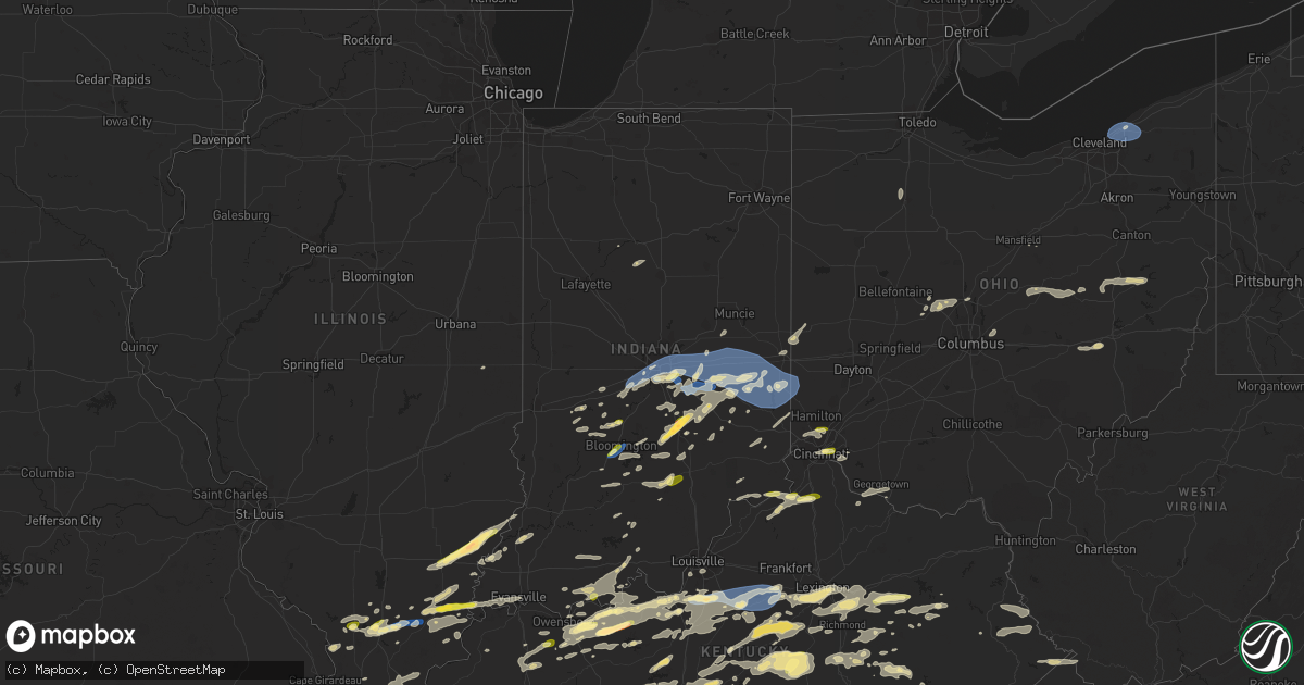
Hail Map in Indiana on July 2, 2023
Get this storm
July 2 map
$229
one time, instant access
Download today. No call, no setup
Keep the $229
Bought the map and want the full workflow? Apply the entire $229 to a subscription within 7 days. None of it is wasted.
Every map, not just this one
This buys you this map. Subscription and you get every map we run, in the markets you choose from a few cities to whole states to nationwide. Plus real-time alerts the moment a storm fires.
Contact data
Name, contact info, occupancy, even credit band for addresses in the footprint. You go from where it hit to who to call.
Become the source they trust
Unlimited branding weather history reports on demand. You already have the documented answer ready for the property owner, and you are the one who showed up with it.
Property data and RoofTrace estimates
Pull up any address you have got, its value and the exact code rules for that jurisdiction, straight from One Click Code. Then RoofTrace estimates the squares, pitch, and roof value, priced the way you price.
Storm reports in Indiana
Indiana
| Date | Description |
|---|---|
| 07/02/20236:05 PM CDT | A local report indicates 1.00 inch wind near 2 S Whitehall |
| 07/02/20236:02 PM CDT | A local report indicates 60 MPH wind near 5 SW Bloomington |
| 07/02/20235:26 PM CDT | Knox county reports multiple trees down in sw vincennes. |
| 07/02/20235:25 PM CDT | Knox county em reports tree/powerlines down along schoolhouse road on the west side of vincennes. |
| 07/02/20234:35 PM CDT | One business on south state road 101 with a roof blown off. |
| 07/02/20234:31 PM CDT | Trees and large branches downed from abington to centerville to richmond. |
| 07/02/20234:30 PM CDT | *** 3 inj *** multiple trees downed around whitewater memorial state park. One tree fell on a tent. Emergency management confirmed three non-life threatening injuries. |
| 07/02/20234:25 PM CDT | Trees and large branches downed across the county. |
| 07/02/20234:20 PM CDT | Tree limbs of unknown size downed. |
| 07/02/20234:19 PM CDT | Tree onto power pole. |
| 07/02/20234:19 PM CDT | Corrects previous tstm wnd dmg report from 2 w grissom afb. Tree onto power lines. Multiple large branches down. |
| 07/02/20234:19 PM CDT | Numerous reports of trees down. Many in connersville... But also through additional areas of the county. |
| 07/02/20234:15 PM CDT | Trees and power lines downed. Time estimated from radar. |
| 07/02/20234:14 PM CDT | Numerous trees and wires down concentrated in northwest franklin county. Time estimated from radar. |
| 07/02/20234:00 PM CDT | Trees down. |
| 07/02/20233:55 PM CDT | A local report indicates 1.00 inch wind near Edinburgh |
| 07/02/20233:53 PM CDT | Several trees and powerlines were blown down in west central rush county from thunderstorm winds. The time is estimated from radar. |
| 07/02/20233:53 PM CDT | Trees down near mt. Pleasant area. |
| 07/02/20233:51 PM CDT | Report from mping: quarter |
| 07/02/20233:46 PM CDT | Social media report of large tree limbs down in spiceland. Time estimated via radar. |
| 07/02/20233:45 PM CDT | Trained spotter measured a 2.00 inch hailstone in edinburgh. |
| 07/02/20233:44 PM CDT | A local report indicates 1.00 inch wind near Edinburgh |
| 07/02/20233:36 PM CDT | *** 1 inj *** falling trees damaged five cars and one rv resulting in one injury. |
| 07/02/20233:36 PM CDT | Several trees snapped in taylorsville. Time estimated from radar. |
| 07/02/20233:32 PM CDT | A local report indicates 1.00 inch wind near Cortland |
| 07/02/20233:25 PM CDT | A local report indicates 65 MPH wind near 3 NNE Fountaintown |
| 07/02/20233:23 PM CDT | At state road 9 and cr 200s in hancock county a 6-inch healthy tree branch was blown down by thunderstorm winds. Time estimated from radar. |
| 07/02/20233:23 PM CDT | At state road 9 and cr 200s in hancock county a 6-inch healthy tree branch was blown down by thunderstorm winds. Time estimated from radar. Relayed from ham radio. |
| 07/02/20233:22 PM CDT | Dime size hail. |
| 07/02/20233:15 PM CDT | A local report indicates 1.00 inch wind near 3 S Paragon |
| 07/02/20233:13 PM CDT | Report from mping: quarter |
| 07/02/20232:57 PM CDT | A local report indicates 65 MPH wind near Monument Circle |
| 07/02/20232:55 PM CDT | Ttraffic lights out at east street and st. Clair street in downtown indianapolis along with downed tree limbs and a couple of small trees nearly uprooted from thunderst |
| 07/02/20232:51 PM CDT | A local report indicates 63 MPH wind near 1 SSW Indianapolis Int' |
| 07/02/20232:46 PM CDT | Power lines and power poles blown down. |
| 07/02/20232:37 PM CDT | Four-inch diameter tree branch was blown off a tree just north of the high school. Street flooding on indiana street. |
| 07/02/20232:26 PM CDT | Several tree limbs up to 5 inches in diameter on county line. |
| 07/02/20232:18 PM CDT | Large tree limb down over road. |
| 07/02/20232:05 PM CDT | Large tree limbs down. Shared by broadcast meteorologist. Also nickel sized hail. |
| 07/02/20231:59 PM CDT | Tree down near sulphur. |
| 07/02/20231:58 PM CDT | A local report indicates 1.00 inch wind near 1 ENE Vevay |
| 07/02/20231:45 PM CDT | Trees down. |
| 07/02/20231:40 PM CDT | Corrects previous tstm wnd dmg report from 4 nnw milan. Corrects previous tstm wnd dmg report from 4 nnw milan. Tree down on power line. Time estimated from radar. |
| 07/02/20231:34 PM CDT | Corrects previous tstm wnd dmg report from 4 nnw milan. Tree down on power line. Time estimated from radar. |
| 07/02/20231:24 PM CDT | Tree down on power line. Time estimated from radar. |
All States Impacted by Hail Map on July 2, 2023
Cities Impacted by Hail Map on July 2, 2023
- Carpio, ND
- Philpot, KY
- Whitesville, KY
- Hawesville, KY
- Reynolds Station, KY
- Cloverport, KY
- Cannelton, IN
- Hardinsburg, KY
- New Market, AL
- Meridianville, AL
- Huntsville, AL
- Corning, AR
- Knobel, AR
- Hamilton, AL
- Guin, AL
- Marion, IL
- Eldorado, IL
- Omaha, IL
- Norris City, IL
- New Haven, IL
- Raleigh, IL
- De Witt, AR
- Wolf Lake, IL
- Utica, KY
- Fordsville, KY
- Pilot Mountain, NC
- Westfield, NC
- Mount Airy, NC
- Athens, AL
- Toney, AL
- Cobden, IL
- Stephensport, KY
- Owensboro, KY
- Galatia, IL
- Broughton, IL
- Hazel Green, AL
- Biggers, AR
- Pittsburg, IL
- Harrisburg, IL
- Carrier Mills, IL
- Carterville, IL
- Herrin, IL
- Shepherdsville, KY
- Lebanon Junction, KY
- Coxs Creek, KY
- Clermont, KY
- Vevay, IN
- Florence, IN
- Warsaw, KY
- Ghent, KY
- Glencoe, KY
- Sparta, KY
- Dry Ridge, KY
- Carbondale, IL
- Murphysboro, IL
- Chaffee, MO
- Stevenson, AL
- Flat Rock, AL
- Fackler, AL
- Crittenden, KY
- West Newton, IN
- Indianapolis, IN
- Plainfield, IN
- Camby, IN
- Mooresville, IN
- Clayton, IN
- Avon, IN
- Beech Grove, IN
- Rising Fawn, GA
- Taylorsville, KY
- Mount Eden, KY
- Waddy, KY
- Lawrenceburg, KY
- Bloomfield, KY
- Fairfield, KY
- Chaplin, KY
- Wilmore, KY
- Versailles, KY
- Salvisa, KY
- Willisburg, KY
- Harrodsburg, KY
- Ordway, CO
- Gosport, IN
- Martinsville, IN
- Bloomington, IN
- New Palestine, IN
- Millersburg, PA
- Elizabethville, PA
- Mifflinburg, PA
- Millmont, PA
- Columbus, IN
- Nashville, IN
- Edinburgh, IN
- Wilkinson, IN
- Mccordsville, IN
- Maxwell, IN
- Greenfield, IN
- Shirley, IN
- Kennard, IN
- New Castle, IN
- Fortville, IN
- Taylorsville, IN
- Gwynneville, IN
- Spiceland, IN
- Arlington, IN
- Carthage, IN
- Knightstown, IN
- Rushville, IN
- Morristown, IN
- Charlottesville, IN
- Fountaintown, IN
- Chickamauga, GA
- Madison, AL
- Harvest, AL
- Milton, PA
- Courtland, MS
- Batesville, MS
- Calhoun, KY
- Brownstown, IN
- Seymour, IN
- De Mossville, KY
- Mill Shoals, IL
- Barnhill, IL
- Golden Gate, IL
- Fairfield, IL
- Albion, IL
- Ellery, IL
- Lithia Springs, GA
- Bone Gap, IL
- Browns, IL
- Clay City, KY
- Jeffersonville, KY
- Winchester, KY
- Means, KY
- Frenchburg, KY
- Mount Carmel, IL
- Princeton, KY
- Fredonia, KY
- Dalhart, TX
- Texline, TX
- Metamora, IN
- Connersville, IN
- Lewisville, IN
- Glenwood, IN
- Laurel, IN
- Falmouth, IN
- Mays, IN
- Brownsville, IN
- Brookville, IN
- Centerville, IN
- Straughn, IN
- Cambridge City, IN
- Greens Fork, IN
- Liberty, IN
- Milton, IN
- Richmond, IN
- Camden, OH
- Boston, IN
- Bath, IN
- College Corner, OH
- West College Corner, IN
- Oxford, OH
- Eaton, OH
- Fraziers Bottom, WV
- Buffalo, WV
- Red House, WV
- Hartley, TX
- Channing, TX
- Kirkwood, PA
- Wiley, CO
- McClave, CO
- Lamar, CO
- Oxford, PA
- Hustonville, KY
- Dumas, TX
- Stanford, KY
- Dayton, KY
- Fort Thomas, KY
- Cincinnati, OH
- Bellevue, KY
- Carrollton, MS
- Liberty, KY
- Middleburg, KY
- Rolette, ND
- Abbeville, MS
- Oxford, MS
- Kit Carson, CO
- Warsaw, OH
- Walhonding, OH
- Irvine, KY
- Cloverdale, IN
- Centerpoint, IN
- Poland, IN
- Coshocton, OH
- Fresno, OH
- Oldenburg, IN
- Madison, IN
- Liberty, WV
- Greensburg, IN
- Milroy, IN
- Burnettsville, IN
- Quincy, IN
- Leon, WV
- Germantown, TN
- Memphis, TN
- Des Moines, NM
- Plantersville, MS
- Shannon, MS
- Bankston, AL
- Fayette, AL
- Eldridge, AL
- Ridgway, IL
- De Soto, IL
- Cambria, IL
- Marysville, OH
- Munfordville, KY
- Grenville, NM
- Clayton, NM
- Vallonia, IN
- Heflin, AL
- Franklin, IN
- Norman, IN
- Bedford, IN
- Medora, IN
- Fayetteville, TN
- Milford Center, OH
- Woodstock, OH
- Equality, IL
- Stone Creek, OH
- Uhrichsville, OH
- Midvale, OH
- Dennison, OH
- Sherrodsville, OH
- Bowerston, OH
- New Philadelphia, OH
- Sugarcreek, OH
- Baltic, OH
- Wagarville, AL
- Brooksville, KY
- Foster, KY
- Groveoak, AL
- Louisville, KY
- Clarkson, KY
- Brilliant, AL
- Winfield, AL
- Hasty, CO
- Granada, CO
- Pope, MS
- Oakland, MS
- Menlo, GA
- Palestine, OH
- Fountain City, IN
- Hollansburg, OH
- New Paris, OH
- Lynn, IN
- Greenville, OH
- New Madison, OH
- Ripley, OH
- Scottsboro, AL
- Estillfork, AL
- Freetown, IN
- Galveston, IN
- Young America, IN
- Flora, IN
- Camden, IN
- Fergus Falls, MN
- Campbell, MN
- Greencastle, IN
- Fillmore, IN
- Coatesville, IN
- La Fayette, GA
- Rock Spring, GA
- Livermore, KY
- Hartford, KY
- Centertown, KY
- Blairs, VA
- Chatham, VA
- Keeling, VA
- Crandall, GA
- Dalton, GA
- Cisco, GA
- Chatsworth, GA
- Howard, OH
- Gambier, OH
- Mount Vernon, OH
- Hodges, AL
- Hackleburg, AL
- Freedom, IN
- Spencer, IN
- Coal City, IN
- Williams, IN
- Vine Grove, KY
- Guston, KY
- Derby, IN
- Delaware, OH
- Stinesville, IN
- Ellettsville, IN
- Carbon Hill, AL
- Nauvoo, AL
- Ostrander, OH
- Campton, KY
- Rogers, KY
- Taft, TN
- Bardstown, KY
- Monrovia, IN
- Felicity, OH
- Georgetown, OH
- Augusta, KY
- Chapmansboro, TN
- Mackville, KY
- Perryville, KY
- Springfield, KY
- Webster, KY
- Irvington, KY
- Ekron, KY
- Brandenburg, KY
- West Point, KY
- Harned, KY
- Muldraugh, KY
- Westport, IN
- Hartsville, IN
- Raywick, KY
- Owensville, IN
- Pomona, IL
- Elba, AL
- Olmsted, IL
- Villa Ridge, IL
- Eddyville, KY
- Bargersville, IN
- Metropolis, IL
- West Paducah, KY
- Tallassee, AL
- Sarah, MS
- Burnt Prairie, IL
- Grayville, IL
- Thornton, AR
- Hampton, AR
- Ellijay, GA
- Normandy, TN
- Marquand, MO
- Sedgewickville, MO
- Patton, MO
- Greenwood, MS
- Sidon, MS
- Cruger, MS
- Kenton, OK
- West Frankfort, IL
- Freeman Spur, IL
- Brewton, AL
- Berea, KY
- Crab Orchard, KY
- Brodhead, KY
- Middletown, IN
- Ozark, AL
- Carmi, IL
- Nicholasville, KY
- Lexington, KY
- Elizabethtown, IN
- Atlanta, GA
- Henagar, AL
- Richmond, KY
- Dundee, KY
- Red Bay, AL
- Wellington, KY
- Manchester, TN
- Dutton, AL
- Lebanon, KY
- Campbellsville, KY
- Brownsville, KY
- Sweeden, KY
- Bee Spring, KY
- Mammoth Cave, KY
- Summerville, GA
- Trion, GA
- Fort Payne, AL
- Brookport, IL
- Golconda, IL
- Belknap, IL
- Karnak, IL
- Grantsburg, IL
- Grand Chain, IL
- Hazleton, IN
- Patoka, IN
- Shawneetown, IL
- Bowling Green, IN
- Gravel Switch, KY
- Parksville, KY
- Sanders, KY
- Hooks, TX
- Texarkana, TX
- Winona, MS
- Duck Hill, MS
- Elizabethtown, IL
- Junction, IL
- Bremen, AL
- Crane Hill, AL
- Fyffe, AL
- Olaton, KY
- Falls Of Rough, KY
- Branson, CO
- Sparkman, AR
- Couch, MO
- Ravenden, AR
- Thayer, MO
- Mammoth Spring, AR
- Ider, AL
- Pisgah, AL
- Ooltewah, TN
- Mount Vernon, IN
- Woodland, AL
- Wedowee, AL
- Delta, AL
- Lancaster, KY
- Alto Pass, IL
- Camden, AL
- Childersburg, AL
- Danville, VA
- Dry Fork, VA
- Cumberland Furnace, TN
- Rockport, IN
- Waco, KY
- Ravenna, KY
- Black Rock, AR
- Princeton, IN
- Maceo, KY
- Lewisport, KY
- Springer, NM
- Raton, NM
- Prestonsburg, KY
- Mount Sherman, KY
- Buffalo, KY
- Bradfordsville, KY
- Jasper, AL
- Dongola, IL
- Evansville, IN
- Sonora, KY
- Springfield, TN
- Hope, IN
- Crenshaw, MS
- Oliver Springs, TN
- Briceville, TN
- Clinton, TN
- Griffin, IN
- Marion, KY
- Kuttawa, KY
- Waldron, IN
- Big Clifty, KY
- Red Boiling Springs, TN
- Franklin, KY
- Portland, TN
- Cross Plains, TN
- Adolphus, KY
- Westmoreland, TN
- Inez, KY
- Warfield, KY
- Beauty, KY
- Tuscaloosa, AL
- McCarley, MS
- Leitchfield, KY
- McDaniels, KY
- Douglasville, GA
- Maud, TX
- Moriarty, NM
- Woodville, AL
- Shelbyville, IN
- Flat Rock, IN
- New Liberty, KY
- Owenton, KY
- Worthville, KY
- Flowery Branch, GA
- Mulberry, TN
- Chattanooga, TN
- Madisonville, KY
- Hanson, KY
- Ezel, KY
- Pleasant View, TN
- Hazel Green, KY
- Okolona, MS
- Ardmore, TN
- English, IN
- Sulphur, IN
- Charlotte, TN
- Ashland City, TN
- Fulton, MS
- Mantachie, MS
- Augusta, GA
- Hephzibah, GA
- Haleyville, AL
- Section, AL
- Blue Ridge, GA
- Epworth, GA
- Cherry Log, GA
- Mount Sterling, KY
- Stanton, KY
- Orleans, IN
- West Baden Springs, IN
- Burgin, KY
- Danville, KY
- Sturgis, KY
- Clay, KY
- Radcliff, KY
- Fort Knox, KY
- Marshall, NC
- Gadsden, AL
- Rainbow City, AL
- Thomasville, AL
- Saint Paul, IN
- Miami, NM
- Branchville, IN
- Leopold, IN
- Saint Croix, IN
- Marengo, IN
- Milltown, IN
- Killen, AL
- Charleston, MO
- Anniston, MO
- Bridgeport, AL
- Sherwood, TN
- Trenton, GA
- South Pittsburg, TN
- Guild, TN
- Bryant, AL
- Boise City, OK
- Beechgrove, TN
- Bradyville, TN
- Wartrace, TN
- Heiskell, TN
- Powell, TN
- Knoxville, TN
- Aurora, IN
- Moores Hill, IN
- Valley Head, AL
- Thompsonville, IL
- Evanston, IN
- Grandview, IN
- Lamar, IN
- Troy, IN
- Millerstown, PA
- Liverpool, PA
- Thompsontown, PA
- Fruitdale, AL
- Prospect, TN
- Vernon Hill, VA
- Halifax, VA
- South Boston, VA
- Sunman, IN
- Milan, IN
- Osgood, IN
- Wickliffe, KY
- Barlow, KY
- La Center, KY
- Hillsboro, AL
- Lineville, AL
- Crestview, FL
- Whitewater, MO
- Advance, MO
- Cape Girardeau, MO
- Bear Creek, AL
- Cub Run, KY
- Clayton, AL
- Graniteville, SC
- Bastrop, LA
- Old Fort, TN
- Steele, AL
- Ashville, AL
- Saint Francisville, IL
- Vincennes, IN
- Allendale, IL
- Springerton, IL
- Enfield, IL
- Uniontown, KY
- Henderson, KY
- Qulin, MO
- Neelyville, MO
- Horse Cave, KY
- Golden, MS
- Parsons, TN
- Wildersville, TN
- Fairfield, AL
- Birmingham, AL
- Bessemer, AL
- Dolomite, AL
- Hollywood, AL
- Southside, TN
- Cunningham, TN
- Vanleer, TN
- Sebree, KY
- Dawson Springs, KY
- Texarkana, AR
- Tullahoma, TN
- Upton, KY
- White Mills, KY
- Chidester, AR
- Bearden, AR
- Camden, AR
- Island, KY
- McIntosh, AL
- Vaiden, MS
- West, MS
- Glasgow, KY
- Pell City, AL
- Riverside, AL
- Creal Springs, IL
- Marble Hill, MO
- Abbeville, AL
- Empire, AL
- Cordova, AL
- Folsom, NM
- Brundidge, AL
- Rosston, AR
- Ranburne, AL
- Tell City, IN
- Karval, CO
- Laconia, IN
- Cimarron, NM
- Petersburg, TN
- Shelbyville, TN
- Leeds, AL
- Dellrose, TN
- Hamburg, AR
- Chrisney, IN
- Tennyson, IN
- Scottsville, KY
- Little River, AL
- Atmore, AL
- Perdido, AL
- McDonald, TN
- Apison, TN
- Sylacauga, AL
- Corona, NM
- Gamaliel, KY
- Lafayette, TN
- Manilla, IN
- Stewart, MS
- Kilmichael, MS
- Jackson, AL
- McKee, KY
- Attalla, AL
- Mora, NM
- Ferdinand, IN
- Saint Anthony, IN
- Birdseye, IN
- Huntingburg, IN
- McEwen, TN
- Dickson, TN
- Holladay, TN
- Darden, TN
- Lexington, TN
- Albertville, AL
- Rainsville, AL
- Slaughters, KY
- Manitou, KY
- Nebo, KY
- Hume, IL
- Cedar Grove, IN
- Oran, MO
- Kevil, KY
- Mounds, IL
- Weogufka, AL
- Mulkeytown, IL
- Royalton, IL
- Rossville, GA
- Stockton, AL
- Russellville, AL
- Mount Vernon, AL
- Wilsonville, AL
- Harpersville, AL
- Senatobia, MS
- Ashland, MS
- Vincent, AL
- Lincoln, AL
- Vandiver, AL
- Ragland, AL
- Cropwell, AL
- Cottondale, AL
- Brookwood, AL
- Holland, KY
- Rome, GA
- Grenada, MS
- Cherokee, AL
- Florence, AL
- Tuscumbia, AL
- Springfield, CO
- Aberdeen, MS
- Houston, MS
- Axis, AL
- Dozier, AL
- Brantley, AL
- Northport, AL
- Paoli, IN
- Sardis, MS
- Odenville, AL
- Trussville, AL
- Moody, AL
- Sylvania, AL
- Bruce, MS
- Banner, MS
- Townley, AL
- Mableton, GA
- Hurricane Mills, TN
- Waverly, TN
- Summersville, KY
- Magnolia, KY
- Hanceville, AL
- Arley, AL
- Cullman, AL
- Lyerly, GA
- Cecilia, KY
- Eastview, KY
- Fairland, IN
- Homer, IN
- Needham, IN
- Boggstown, IN
- Greenwood, IN
- Garfield, KY
- Rhodelia, KY
- Boston, KY
- Rineyville, KY
- Union Star, KY
- Grantsburg, IN
- Mount Washington, KY
- Rome, IN
- Elizabethtown, KY
- Payneville, KY
- Bristow, IN
- Crossville, IL
- Ward, AL
- Butler, AL
- Pennington, AL
- Landenberg, PA
- Newark, DE
- Wilmington, DE
- Hockessin, DE
- Eads, CO
- Sheridan Lake, CO
- Holly, CO
- Syracuse, KS
- Amarillo, TX
- Masterson, TX
- Panhandle, TX
- Mylo, ND
- Agate, ND
- Wolford, ND
- Bisbee, ND
- Cando, ND
- Smyrna, TN
- Murfreesboro, TN
- Kendall, KS
- Lakin, KS
- Chesterland, OH
- Cleveland, OH
- Eastlake, OH
- Willoughby, OH
- Wickliffe, OH
- Euclid, OH
- Gates Mills, OH
- Beachwood, OH
- Chardon, OH
- Mentor, OH
- Banner Elk, NC
- Boone, NC
- Vilas, NC
- Andersonville, TN
- Corryton, TN
- Maynardville, TN
- Laverne, OK
- Fairfield, OH
- Reed, KY
- Shipman, VA
- Howardsville, VA
- Esmont, VA
- Schuyler, VA
- Wingina, VA
- Montevideo, MN
- Maynard, MN
- Pikeville, KY
- Pilgrim, KY
- Colby, KS
- Danvers, MN
- Dumont, MN
- Wheaton, MN
- Donnelly, MN
- Norcross, MN
- Herman, MN
- Water Valley, MS
- Beattyville, KY
- Vincent, KY
- Mauk, GA
- Butler, GA
- Reynolds, GA
- Leesburg, GA
- Dalmatia, PA
- Summertown, TN
- Arlington, TN
- Smiths Grove, KY
- Bowling Green, KY
- Yosemite, KY
- Elk Horn, KY
- Waynesburg, KY
- Kings Mountain, KY
- Sylvester, GA
- Clarksville, TN
- Sugar Grove, NC
- Graham, AL
- Young Harris, GA
- Hiawassee, GA
- Hayesville, NC
- Elk Park, NC
- Van Buren, OH
- Findlay, OH
- McComb, OH
- Luverne, AL
- Ricetown, KY
- Sextons Creek, KY
- Mistletoe, KY
- Oneida, KY
- Tyner, KY
- Manchester, KY
- Booneville, KY
- Bloomfield, IN
- Springville, IN
- New Concord, OH
- Cumberland, OH
- Cambridge, OH
- Chandlersville, OH
- Fountain Run, KY
- Mount Hermon, KY
- Tompkinsville, KY
- Blacklick, OH
- New Albany, OH
- Pataskala, OH
- Hale Center, TX
- Gainesville, GA
- Braselton, GA
- Hoschton, GA
- Kenna, WV
- Walton, WV
- Charleston, WV
- Advent, WV
- Greensburg, KY
- Canmer, KY
- Winona, KS
- Wallace, KS
- Stewart, TN
- Dover, TN
- Berry, AL
- Steele, KY
- Kimper, KY
- Hurley, VA
- Phelps, KY
- Newhebron, MS
- Mendenhall, MS
- Mount Olive, MS
- Prentiss, MS
- Magee, MS
- Trenton, NE
- Given, WV
- Como, MS
- Palmyra, TN
- Letohatchee, AL
- Batavia, OH
- Milford, OH
- Mount Vernon, KY
- Walsh, CO
- Lucas, OH
- Tiger, GA
- Clayton, GA
- Santa Rosa, NM
- Vance, AL
- Woodstock, AL
- West Blocton, AL
- Ellaville, GA
- Rockford, AL
- Rocky Face, GA
- Inman, SC
- Campobello, SC
- Greer, SC
- Lyman, SC
- Taylors, SC
- Wellford, SC
- Fieldton, TX
- Olton, TX
- Honoraville, AL
- Greenville, AL
- Mannsville, KY
- Nettleton, MS
- Gay, WV
- Ripley, WV
- Shelby, AL
- Columbiana, AL
- Chokio, MN
- Covington, KY
- Newport, KY
- Waverly Hall, GA
- Leoti, KS
- Rupert, GA
- Friendship, TN
- Knifley, KY
- Columbia, KY
- Buhl, AL
- Coker, AL
- Garita, NM
- Minter, AL
- Millington, TN
- Sugar Tree, TN
- Griffin, GA
- Locust Grove, GA
- Hampton, GA
- Linville, NC
- Spearman, TX
- Heltonville, IN
- Starkville, MS
- Perryton, TX
- Smithville, GA
- Americus, GA
- Blowing Rock, NC
- Newland, NC
- Austell, GA
- West Liberty, KY
- Poca, WV
- Gandeeville, WV
- Old Fort, NC
- Inverness, MS
- Cumberland City, TN
- Erin, TN
- Spring Hill, TN
- Columbia, TN
- Burnside, KY
- Somerset, KY
- Glen Burnie, MD
- Severn, MD
- Hudson, KY
- Lambert, MS
- Cedar Hill, TN
- Adams, TN
- Newcomerstown, OH
- Itta Bena, MS
- Lucas, KY
- Minor Hill, TN
- Leoma, TN
- Anderson, AL
- Five Points, TN
- Lexington, AL
- Corinth, MS
- Callands, VA
- Sandgap, KY
- Orlando, KY
- London, KY
- Burns, TN
- Bon Aqua, TN
- Las Vegas, NM
- Felt, OK
- Montgomery, AL
- Auburn, GA
- Winder, GA
- Holly Springs, MS
- College Grove, TN
- Chapel Hill, TN
- Lewisburg, TN
- Andersonville, GA
- Thomaston, GA
- Stopover, KY
- Phyllis, KY
- Fedscreek, KY
- Panther, WV
- Eagleville, TN
- Rockvale, TN
- Pearson, GA
- Nebo, NC
- Landrum, SC
- Stuart, VA
- Mize, KY
- Elkview, WV
- Rutledge, AL
- Pasadena, MD
- Gibson Island, MD
- Woodlawn, TN
- Liberty, TX
- Java, VA
- Norwich, OH
- Zanesville, OH
- Perrysville, OH
- Buckhorn, KY
- Pine Apple, AL
- York, AL
- Demopolis, AL
- Bellamy, AL
- Adairville, KY
- Knob Lick, KY
- Park City, KY
- Edmonton, KY
- Amelia, OH
- Lake Lure, NC
- Macon, GA
- Musella, GA
- Douglas, GA
- Cave City, KY
- Oakland, KY
- Hardyville, KY
- Orlinda, TN
- Milner, GA
- Barnesville, GA
- Dundee, MS
- Culloden, GA
- Axton, VA
- Martinsville, VA
- Arrington, TN
- Lizella, GA
- Jefferson, GA
- Travelers Rest, SC
- Greenville, SC
- Meridian, MS
- Frankewing, TN
- Montezuma, GA
- Louisa, KY
- Kermit, WV
- River, KY
- Ulysses, KY
- Lovely, KY
- Tomahawk, KY
- Paintsville, KY
- Alamo, TN
- Tennessee Ridge, TN
- Taylor, MS
- Devers, TX
- Center, KY
- Valdosta, GA
- Byhalia, MS
- Hodgenville, KY
- New Haven, KY
- Gruver, TX
- Livingston, KY
- Wetumpka, AL
- Equality, AL
- Roberta, GA
- Humboldt, TN
- Double Springs, AL
- Buckatunna, MS
- Waynesboro, MS
- Albany, GA
- Tribune, KS
- Marion, NC
- Roberts, MT
- Lodge Grass, MT
- Sizerock, KY
- Hyden, KY
- Park, KS
- Gove, KS
- Fromberg, MT
- Arrington, VA
- Fishtail, MT
- Annville, KY
- Emigrant, MT
- Paragon, IN
- Red Lodge, MT
- Roscoe, MT
- Moscow, KS
- Pryor, MT
- Collierville, TN
- Cordova, TN
- Rogersville, AL
- Mohawk, WV
- Bridger, MT
- Wyola, MT
- Garden City, KS
- Malta, MT
- Juliette, GA
- Lawsonville, NC
- Holcomb, KS
- Mocksville, NC
- Satanta, KS
- Ulysses, KS
- Greenwood Springs, MS
- Trafalgar, IN
- Sublette, KS
- Nineveh, IN
- Whiteland, IN
- Grand Rapids, MN
- Molt, MT
- Cohagen, MT
- Park City, MT
- Joliet, MT
- Columbus, MT
- Terry, MT
- Reed Point, MT
- Vinemont, AL
- Forsyth, MT
- Falkville, AL
- Hartselle, AL


