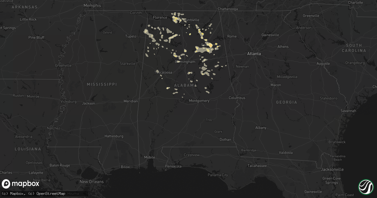
Hail Map in Alabama on July 1, 2026
Get this storm
July 1 map
$229
one time, instant access
Download today. No call, no setup
Keep the $229
Bought the map and want the full workflow? Apply the entire $229 to a subscription within 7 days. None of it is wasted.
Every map, not just this one
This buys you this map. Subscription and you get every map we run, in the markets you choose from a few cities to whole states to nationwide. Plus real-time alerts the moment a storm fires.
Contact data
Name, contact info, occupancy, even credit band for addresses in the footprint. You go from where it hit to who to call.
Become the source they trust
Unlimited branding weather history reports on demand. You already have the documented answer ready for the property owner, and you are the one who showed up with it.
Property data and RoofTrace estimates
Pull up any address you have got, its value and the exact code rules for that jurisdiction, straight from One Click Code. Then RoofTrace estimates the squares, pitch, and roof value, priced the way you price.
Storm reports in Alabama
Alabama
| Date | Description |
|---|---|
| 07/01/20266:15 PM CDT | Numerous trees and powerlines down in and around the city of sylacauga. Trees fell onto at least two structures. |
| 07/01/20266:05 PM CDT | Several trees were blown down just off al-75 northeast of oneonta. |
| 07/01/20266:02 PM CDT | Mulitple trees down at intersection of cr 89 and hwy 64. Time estiamted by radar. |
| 07/01/20266:02 PM CDT | Multiple trees down at intersection of sr 515 and cr 523. Time estimated from radar. |
| 07/01/20266:02 PM CDT | Multiple trees down on county road 89. Time estimated from radar. |
| 07/01/20266:00 PM CDT | Several trees were blown down in the tates gap loop and airport road area. |
| 07/01/20265:48 PM CDT | Picture of golfball sized hail in hokes bluff. Time estimated by radar. |
| 07/01/20265:44 PM CDT | Tree down on highway 64 near highway 207. Time estimated from radar. |
| 07/01/20265:42 PM CDT | Large tree blocking road. |
| 07/01/20265:42 PM CDT | Multiple trees down in the intersection of cr 155 & 156 with complete blockage; time estimated from radar. |
| 07/01/20265:34 PM CDT | Tree downed onto a power line near county road 86. Time estimated from radar. |
| 07/01/20265:34 PM CDT | Tree downed onto a power line near county roads 92 and 555. Time estimated from radar. |
| 07/01/20265:30 PM CDT | Tree down in elkmont. Time estimated from radar. |
| 07/01/20265:26 PM CDT | Tree down at intersection of cr 555 and cr 92; time estimated from radar. |
| 07/01/20265:26 PM CDT | Trees down and shutters blew off a house near cairo. Time estimated from radar. |
| 07/01/20265:26 PM CDT | Picture from social media of multiple trees down... With one on a vehicle. Time estimated from radar. |
| 07/01/20265:10 PM CDT | Two trees down at cotton belt rd and hardaway loop. Time estimated from radar. |
| 07/01/20265:07 PM CDT | Report from social media of trees down on lentzville road. Time estimated from radar. |
| 07/01/20265:07 PM CDT | Report from social media of trees down on baker hill road. Time estimated from radar. |
| 07/01/20264:57 PM CDT | Picture from social media of a tree down on strain road. Time estimated from radar. |
| 07/01/20264:55 PM CDT | Power lines down on the road near school house lane. Time estimated from radar. |
| 07/01/20264:46 PM CDT | Picture and report from social media of a power pole and three transformers down on escue drive. Time estimated from radar. |
| 07/01/20264:45 PM CDT | A tree fell across highway 49 north of lineville... Blocking both lanes. |
| 07/01/20264:41 PM CDT | One tree and at least 3 large limbs down on mcvey rd. |
| 07/01/20264:24 PM CDT | Trees down on mt. Olive road. Time estimated. |
| 07/01/20263:57 PM CDT | Tree down on a house near 4th and 7th street. Time estimated from radar. |
| 07/01/20263:54 PM CDT | Picture from social media of large tree branches and power lines down near 5th court. Time estimated from radar. |
| 07/01/20263:54 PM CDT | Tree downed on a residence near 4th street. Time estiimated from radar. |
| 07/01/20263:49 PM CDT | Tree down in russellville. Time estimated from radar. |
| 07/01/20263:44 PM CDT | Multiple trees down on old vina road. Time estimated from radar. |
| 07/01/20263:44 PM CDT | Tree down near county road 23 and cedar street. Time estimated from radar. |
| 07/01/20263:44 PM CDT | Tree down on county road 58 near the frankfort community. Time estimated from radar. |
| 07/01/20263:44 PM CDT | Tree down near county road 124. Time estimated from radar. |
| 07/01/20263:44 PM CDT | Tree down near county road 16 and county road 224. Time estimated from radar. |
| 07/01/20263:44 PM CDT | Tree down near county road 23. Time estimated from radar. |
| 07/01/20263:41 PM CDT | Tree down and power lines down near potts street. Time estimated from radar. |
| 07/01/20263:41 PM CDT | Tree down near county road 21. Time estimated from radar. |
| 07/01/20263:41 PM CDT | Tree down on tuscaloosa street. Time estimated from radar. |
| 07/01/20263:41 PM CDT | Tree down near clay avenue. Time estimated from radar. |
| 07/01/20263:41 PM CDT | Tree down near duncan creek road. Time estimated from radar. |
| 07/01/20263:41 PM CDT | Tree down on summit street. Time estimated from radar. |
| 07/01/20263:41 PM CDT | Tree down on underwood road. Time estimated from radar. |
| 07/01/20263:35 PM CDT | Trees and power lines were downed around hamilton. |
| 07/01/20263:30 PM CDT | Tree down on county road 57. Time estimated from radar. |
| 07/01/20263:27 PM CDT | Trees and power lines were downed around hackleburg. |
| 07/01/20263:18 PM CDT | Tree down near whipporwill ln and cr 211. Time estimated. |
| 07/01/20263:17 PM CDT | Trees and power lines were downed around bear creek. |
| 07/01/20263:11 PM CDT | Photo from social media of a tree split and downed onto power lines. Time estimated from radar. |
| 07/01/20263:09 PM CDT | Trees and power lines were downed around the marion county side of haleyville. |
| 07/01/20263:06 PM CDT | Quarter-size hail reported around 3 miles north of haleyville. |
| 07/01/20262:47 PM CDT | Photo and report from social media of a tree down on a house near county road 110 and 460. Time estimated from radar. |
| 07/01/20262:46 PM CDT | Trees down. |
| 07/01/20262:40 PM CDT | Tree down. |
| 07/01/20262:11 PM CDT | Tree down. |
| 07/01/20262:09 PM CDT | Tree uprooted and on lines. |
| 07/01/20261:59 PM CDT | A tree was knocked down onto a power line. Power was out at this location at 217 reel road. |
| 07/01/20261:59 PM CDT | Corrects previous hail report from 1 e powell. A tree was knocked down onto a power line. Power was out at this location at 217 reel road. |
| 07/01/20261:57 PM CDT | Trees down blocking one lane. |
| 07/01/20261:51 PM CDT | Tree down on lines. |
| 07/01/20261:51 PM CDT | Tree down. |
| 07/01/20261:20 PM CDT | Quarter sized hail reported at neacc. |
| 07/01/20261:00 PM CDT | Trees downed on birmingport rd. |
| 07/01/202612:59 PM CDT | Hail up to quarter sized near hulaco reported. |
| 07/01/202612:26 PM CDT | Tree down blocking roadway. |
All States Impacted by Hail Map on July 1, 2026
Cities Impacted by Hail Map on July 1, 2026
- Pine River, WI
- Poy Sippi, WI
- Fremont, WI
- Berlin, WI
- Winneconne, WI
- Northwood, IA
- Saint Ansgar, IA
- Lyle, MN
- Glenville, MN
- Neshkoro, WI
- Chatfield, MN
- Dover, MN
- Princeton, WI
- Spring Valley, MN
- Stewartville, MN
- Saint Charles, MN
- Utica, MN
- Eyota, MN
- Lewiston, MN
- Rushford, MN
- Winona, MN
- Omro, WI
- Green Lake, WI
- Austin, MN
- Montello, WI
- Larsen, WI
- Neenah, WI
- Hortonville, WI
- New London, WI
- Ripon, WI
- Pickett, WI
- Appleton, WI
- Shiocton, WI
- Black Creek, WI
- Oshkosh, WI
- Greenville, WI
- Markesan, WI
- Hilbert, WI
- Chilton, WI
- Stockbridge, WI
- Fairwater, WI
- Brandon, WI
- Waupun, WI
- Greenleaf, WI
- Little Chute, WI
- Kaukauna, WI
- Seymour, WI
- De Pere, WI
- Wrightstown, WI
- Elma, IA
- Oneida, WI
- Green Bay, WI
- New Franken, WI
- Luxemburg, WI
- Suamico, WI
- Casco, WI
- Algoma, WI
- Brussels, WI
- Kewaunee, WI
- Forestville, WI
- Combined Locks, WI
- Kimberly, WI
- Menasha, WI
- Denmark, WI
- Manitowoc, WI
- Whitelaw, WI
- Francis Creek, WI
- Cresco, IA
- Ridgeway, IA
- Lime Springs, IA
- Mishicot, WI
- Maribel, WI
- Decorah, IA
- Sturgeon Bay, WI
- Mount Calvary, WI
- Malone, WI
- Saint Cloud, WI
- Two Rivers, WI
- Fond Du Lac, WI
- Dorchester, IA
- Spring Grove, MN
- New Albin, IA
- Elkhart Lake, WI
- New Holstein, WI
- Caledonia, MN
- Eitzen, MN
- Glenbeulah, WI
- Genoa, WI
- Cleveland, WI
- Ferryville, WI
- De Soto, WI
- Sheboygan, WI
- Viroqua, WI
- Westby, WI
- Chaseburg, WI
- Soldiers Grove, WI
- Gays Mills, WI
- La Farge, WI
- Viola, WI
- Richland Center, WI
- Stoddard, WI
- Hillsboro, WI
- Cazenovia, WI
- Thompsonville, MI
- La Valle, WI
- Reedsburg, WI
- Hillpoint, WI
- Lime Ridge, WI
- Lyndon Station, WI
- Manistee, MI
- Wisconsin Dells, WI
- Loganville, WI
- Traverse City, MI
- Interlochen, MI
- Buckley, MI
- Lake Leelanau, MI
- Kewadin, MI
- Williamsburg, MI
- Cedar, MI
- Elk Rapids, MI
- Northport, MI
- Suttons Bay, MI
- Maple City, MI
- Wellston, MI
- Brethren, MI
- Kingsley, MI
- Baraboo, WI
- Ludington, MI
- Rapid City, MI
- Scottville, MI
- Free Soil, MI
- Oxford, WI
- Portage, WI
- Briggsville, WI
- Endeavor, WI
- Dalton, WI
- Mancelona, MI
- Alden, MI
- Elmira, MI
- Bellaire, MI
- Frederic, MI
- Gaylord, MI
- Custer, MI
- Fountain, MI
- Johannesburg, MI
- Marquette, WI
- Kingston, WI
- Branch, MI
- Grayling, MI
- Pardeeville, WI
- Hillman, MI
- Atlanta, MI
- Lewiston, MI
- Rosendale, WI
- Eldorado, WI
- Oakfield, WI
- Hubbard Lake, MI
- Harrison, MI
- Curran, MI
- Reed City, MI
- Leroy, MI
- Ossineke, MI
- Spruce, MI
- Black River, MI
- Lincoln, MI
- Evart, MI
- Dallas, PA
- Shavertown, PA
- Eden, WI
- Hunlock Creek, PA
- Birmingham, AL
- Joppa, AL
- Baileyton, AL
- Plymouth, WI
- Gladwin, MI
- Adamsville, AL
- Mulga, AL
- Rhodes, MI
- Beaverton, MI
- Dutton, AL
- Graysville, AL
- Sheboygan Falls, WI
- Kohler, WI
- Sterling, MI
- Standish, MI
- Bentley, MI
- Random Lake, WI
- Adell, WI
- Waldo, WI
- Cascade, WI
- Kiel, WI
- Dora, AL
- Quinton, AL
- Bessemer, AL
- Cordova, AL
- Section, AL
- Hahnville, LA
- Vinemont, AL
- Danville, AL
- Oostburg, WI
- Talking Rock, GA
- Ellijay, GA
- Dawson, AL
- Addison, AL
- Parrish, AL
- Eva, AL
- Fyffe, AL
- Groveoak, AL
- Blairsville, GA
- Jasper, AL
- Childersburg, AL
- Beaverton, AL
- Moulton, AL
- Collinsville, AL
- Coeymans Hollow, NY
- Hannacroix, NY
- Columbiana, AL
- Wilsonville, AL
- Haleyville, AL
- Winfield, AL
- Houston, AL
- Suches, GA
- Gardendale, AL
- Marion, AL
- Hamilton, AL
- Buhl, AL
- Nauvoo, AL
- Carbon Hill, AL
- Double Springs, AL
- Echola, AL
- Eldridge, AL
- Phil Campbell, AL
- Brilliant, AL
- Selma, AL
- West Coxsackie, NY
- Marksville, LA
- Atlanta, GA
- Guin, AL
- Kingston, NY
- Pinellas Park, FL
- Seminole, FL
- Fayette, AL
- Mount Hope, AL
- Elrod, AL
- Coker, AL
- Town Creek, AL
- Greenwood Springs, MS
- Ulster Park, NY
- Port Ewen, NY
- Saint Petersburg, FL
- Gordo, AL
- Russellville, AL
- Fairburn, GA
- Douglasville, GA
- Calera, AL
- Hodges, AL
- Hackleburg, AL
- Vina, AL
- Sulligent, AL
- Vernon, AL
- Marble, NC
- Murphy, NC
- Laceys Spring, AL
- Golden, MS
- Moundville, AL
- Falkville, AL
- Hayden, AL
- Warrior, AL
- Millport, AL
- Red Bay, AL
- Homestead, FL
- Hillsboro, AL
- Townsend, MT
- Broadview, NM
- Somerville, AL
- Palmetto, GA
- Lake Charles, LA
- Westlake, LA
- Sulphur, LA
- Pollock, LA
- Trafford, AL
- Deville, LA
- Morris, AL
- Valhermoso Springs, AL
- Tremont, MS
- Cisco, GA
- Chatsworth, GA
- Huntsville, AL
- Plant City, FL
- Kimberly, AL
- Whitesburg, GA
- Fosters, AL
- Ralph, AL
- Eastaboga, AL
- Lincoln, AL
- Madison, AL
- Darlington, WI
- Vidalia, LA
- Fulton, MS
- Aberdeen, MS
- Riverside, AL
- Plantersville, MS
- Nettleton, MS
- Lakeland, FL
- Pell City, AL
- Central Bridge, NY
- Delta, AL
- Lineville, AL
- Tupelo, MS
- Amory, MS
- Jena, LA
- Wedowee, AL
- Ragland, AL
- Esperance, NY
- Sloansville, NY
- Columbus, MS
- Colfax, LA
- Dry Prong, LA
- Tallapoosa, GA
- Lansing, NY
- Merryville, LA
- Verona, MS
- Smithville, MS
- Tanner, AL
- Talladega, AL
- Tuscaloosa, AL
- Argyle, WI
- Belmont, MS
- Dennis, MS
- Vega, TX
- Ohatchee, AL
- Alexandria, AL
- Wellington, AL
- Ragley, LA
- Anniston, AL
- Ferriday, LA
- Dequincy, LA
- Quitman, MS
- Redfield, NY
- Camden, NY
- Woodland, AL
- Heflin, AL
- Westdale, NY
- Williamstown, NY
- Altmar, NY
- Athens, AL
- Jonesville, LA
- Prairie, MS
- West Point, MS
- Booneville, MS
- Glen, MS
- Corinth, MS
- Macon, MS
- Newton, TX
- Jacksonville, AL
- Gadsden, AL
- Brooksville, MS
- Springville, AL
- Ashville, AL
- Philadelphia, MS
- Coopersburg, PA
- Quakertown, PA
- Richlandtown, PA
- Crawford, MS
- Alexander City, AL
- Piedmont, AL
- Decatur, AL
- Okolona, MS
- Cleveland, NY
- Houston, MS
- Woodland, MS
- Taberg, NY
- West Leyden, NY
- Eclectic, AL
- Equality, AL
- Rainsville, AL
- Sicily Island, LA
- Sylacauga, AL
- Ripley, MS
- Natchez, MS
- Randolph, MS
- Grady, NM
- Melrose, NM
- Rainbow City, AL
- Rogersville, AL
- Clayton, LA
- Waterproof, LA
- Elkmont, AL
- Blue Mountain, MS
- New Albany, MS
- Jones, AL
- Toney, AL
- Harvest, AL
- Kintnersville, PA
- Trout, LA
- Delanson, NY
- Starkville, MS
- Fultonville, NY
- Amsterdam, NY
- Daleville, MS
- Anderson, AL
- Lester, AL
- Mantee, MS
- Pheba, MS
- Maben, MS
- Ashland, AL
- Adamsville, TN
- Bethel Springs, TN
- Schenectady, NY
- Franklinton, LA
- Tylertown, MS
- Steele, AL
- Wadley, AL
- Cragford, AL
- Goodwater, AL
- Deweyville, TX
- Alpine, AL
- Elida, NM
- Hereford, TX
- Friona, TX
- Banner, MS
- Water Valley, MS
- Bruce, MS
- Mathiston, MS
- Oneonta, AL
- Floyd, NM
- Greenwood, MS
- Call, TX
- Kirbyville, TX
- Dumas, TX
- Verona, NY
- Rome, NY
- Rockford, AL
- Keeseville, NY
- Altoona, AL
- Bailey, MS
- Itta Bena, MS
- Vicksburg, MS
- Henderson, TN
- Jasper, TX
- Vaughan, MS
- Attalla, AL
- Tallassee, AL
- Saint Joseph, LA
- Buhl, ID
- Castleford, ID
- Carthage, MS
- Benton, MS
- Yazoo City, MS
- Lakeview, TX
- Coffeeville, MS
- Colchester, VT
- Westford, VT
- Essex Junction, VT
- Whiteville, TN
- Bolivar, TN
- Boaz, AL
- Moorhead, MS
- Verbena, AL
- Sumrall, MS
- Guntersville, AL
- Grant, AL
- Pinson, TN
- Brookhaven, MS
- Weogufka, AL
- Crossville, AL
- Albertville, AL
- South Burlington, VT
- Ballston Lake, NY
- Waynesboro, TN
- Lawrenceburg, TN
- Moscow, TN
- Oneida, NY
- Durhamville, NY
- Holly Springs, MS
- Rolling Fork, MS
- Tillatoba, MS
- Mercer, TN
- Medon, TN
- Wesson, MS
- Williston, VT
- Lexington, MS
- Underhill, VT
- Jericho, VT
- Broaddus, TX
- Lorman, MS
- Silver City, MS
- Oakland, MS
- Newellton, LA
- Perkinston, MS
- Vancleave, MS
- Lucedale, MS
- Langston, AL
- Pattison, MS
- Duck Hill, MS
- Vernon Center, NY
- Clinton, NY
- Vernon, NY
- Carson, MS
- Oak Vale, MS
- Prentiss, MS
- Cascilla, MS
- Charleston, MS
- Clarendon, TX
- Scobey, MS
- Fairfax, VT
- Richmond, VT
- Clanton, AL
- Munnsville, NY
- Canastota, NY
- Spencerport, NY
- Rochester, NY
- Isola, MS
- West Winfield, NY
- Jemison, AL
- Oriskany Falls, NY
- Deansboro, NY
- Cape Vincent, NY
- Hedley, TX
- Panhandle, TX
- Osage, IA
- Fayette, MS
- Batesville, MS
- Sugar Run, PA
- Belzoni, MS
- Mansfield, LA
- Rapid City, SD
- Clayton, NY
- Humboldt, TN
- Winnsboro, LA
- Hartwick, NY
- Burlington Flats, NY
- Ogdensburg, NY
- Freeville, NY
- Woodville, AL
- New Hope, AL
- Rayville, LA
- Hammond, NY
- Grand Cane, LA
- Little Cedar, IA
- Waterville, NY
- Madison, NY
- Depauville, NY
- Chaumont, NY
- La Fargeville, NY
- Etoile, TX
- Spring Hill, TN
- Carthage, NY
- Ithaca, NY
- Elkton, MN
- Adams, MN
- Edwards, MS
- Theresa, NY
- Watertown, NY
- Dexter, NY
- Trenton, GA
- Heuvelton, NY
- Stacyville, IA
- Tutwiler, MS
- Black Hawk, SD
- Hinsdale, MT
- Groom, TX
- West Burlington, NY
- Philadelphia, NY
- Evans Mills, NY
- Box Elder, SD
- Rochester, MN
- Owens Cross Roads, AL
- Delhi, LA
- Tunkhannock, PA
- Claude, TX
- Fort Drum, NY
- Black River, NY
- Brownville, NY
- Calcium, NY
- Riceville, IA
- Edwards, NY
- Dows, IA
- Popejoy, IA
- Alden, IA
- Bastrop, LA
- Grand Meadow, MN
- Racine, MN
- Iowa Falls, IA
- Wallace, KS
- Grass Range, MT
- Hallstead, PA
- Sparta, WI
- Latimer, IA
- Inverness, MS
- Syracuse, KS
- Chester, IA
- McIntire, IA
- Hampton, IA
- Lowville, NY
- Coulter, IA
- Pattersonville, NY
- Marion, LA
- Copenhagen, NY
- Mankato, MN
- Good Thunder, MN
- Spearfish, SD
- Whitewood, SD
- Colby, KS
- Lelia Lake, TX
- Amarillo, TX
- Quimby, IA
- Holstein, IA
- Tomah, WI
- Warrens, WI
- Canton, MS
- Walsh, CO
- Two Buttes, CO
- Washta, IA
- Tribune, KS
- Rexford, NY
- Canyon, TX
- Camden, MS
- Alplaus, NY
- Albany, NY
- Saratoga Springs, NY
- Stillwater, NY
- Slingerlands, NY
- Alta, IA
- Aurelia, IA
- Cherokee, IA
- Melrose, WI
- Clifton Park, NY
- Delmar, NY
- Winona, KS
- Latham, NY
- Rexford, KS
- Owls Head, NY
- Ostrander, MN
- Coolidge, KS
- Altura, MN
- Levant, KS
- Lloyd, MT
- Chinook, MT
- Hays, MT
- Selden, KS
- Lyon Mountain, NY
- Ellenburg Center, NY
- Saranac, NY
- Chateaugay, NY
- Averill Park, NY
- Petersburg, NY
- Cropseyville, NY
- Linn Grove, IA
- Gem, KS
- Hoxie, KS
- Glenmont, NY
- Le Roy, MN
- Waseca, MN
- Janesville, MN
- Kendall, KS
- Lakin, KS
- Leoti, KS
- North Creek, NY
- Bakers Mills, NY
- Cadyville, NY
- Pownal, VT
- Harmony, MN
- Coxsackie, NY
- Sioux Rapids, IA
- Rembrandt, IA
- Morrisonville, NY
- Ellenburg Depot, NY
- Sand Lake, NY
- Stephentown, NY
- Rensselaer, NY
- Castleton On Hudson, NY
- Vale, SD
- Morristown, MN
- Waterville, MN
- Wells, VT
- West Pawlet, VT
- Salem, NY
- Granville, NY
- South Hero, VT
- Livingston Manor, NY
- Canton, MN
- Mabel, MN
- La Crosse, WI
- Greenville, IA
- Plattsburgh, NY
- Vergennes, VT
- Charlotte, VT
- Peru, NY
- Burlington, VT
- Shelburne, VT
- Poultney, VT
- Middletown Springs, VT
- Warrensburg, NY
- Bolton Landing, NY
- Deerfield, KS
- Pittsford, VT
- Ferrisburgh, VT
- North Ferrisburgh, VT
- Rockland, WI
- Coon Valley, WI
- Bangor, WI
- Gillett Grove, IA
- Pawlet, VT
- Willsboro, NY
- Parksville, NY
- Milton, VT
- Grand Isle, VT
- Spencer, IA
- Salisbury, VT
- Atwood, KS
- Diamond Point, NY
- Ettrick, WI
- West Rupert, VT
- Middlebury, VT
- Bridport, VT
- Ruthven, IA
- Graettinger, IA
- Cashton, WI
- Preston, MN
- Winooski, VT
- Hinesburg, VT
- Waterbury, VT
- Sheffield, MA
- Housatonic, MA
- South Egremont, MA
- Great Barrington, MA
- Rowe, MA
- Colrain, MA
- Holcomb, KS
- Wilton, WI
- Norwalk, WI
- Ontario, WI
- Canaan, CT
- Southfield, MA
- Ashley Falls, MA
- Brewster, KS
- Kendall, WI
- Camp Douglas, WI
- Dresden, KS
- Hot Springs Village, AR
- Gill, MA
- South Pomfret, VT
- North Pomfret, VT
- Lansing, IA
- Norton, KS
- Clayton, KS
- Jennings, KS
- West Lebanon, NH
- Plainfield, NH
- Sharon, VT
- Norwich, VT
- White River Junction, VT
- Hustler, WI
- Elroy, WI
- Mauston, WI
- New Lisbon, WI
- Necedah, WI
- Garden City, KS
- Scott City, KS
- Marienthal, KS
- Oberlin, KS
- Norcatur, KS
- Glennie, MI
- Mikado, MI
- Harrisville, MI
- Saint Francis, KS
- Benkelman, NE
- Friendship, WI
- Arkdale, WI
- Adams, WI
- Coloma, WI
- Plainfield, WI
- Hancock, WI
- Nekoosa, WI
- Bancroft, WI
- Greenbush, MI
- Lebanon, NH
- Lyons, CO
- Hanover, NH
- Wilder, VT
- Newport, NH
- Grantham, NH
- Webster, MA
- Parks, NE
- Grand Marsh, WI
- Westfield, WI
- Eads, CO
- Manchester, CT
- Vernon Rockville, CT
- Bolton, CT
- Lonsdale, AR
- Hot Springs National Park, AR
- Springfield, NH
- East Hartford, CT
- Douglas, MA
- Wautoma, WI
- Cheyenne Wells, CO
- Wilmot, NH
- Arapahoe, CO
- Warner, NH
- Uxbridge, MA
- Jordan, MT
- Coventry, CT
- Andover, CT
- Wonewoc, WI
- Canterbury, NH
- Morland, KS
- Kit Carson, CO
- Albert Lea, MN
- Readstown, WI
- Lenora, KS
- Hayward, MN
- West Salem, WI
- Hill City, KS
- Brownsville, MN
- Holmen, WI
- Mindoro, WI
- Fort Peck, MT
- Wolf Point, MT
- Circle, MT
- Nashua, MT
- Frazer, MT
- Vida, MT
- Logan, KS
- Lake Ann, MI
- Honor, MI
- Ault, CO
- Beulah, MI
- Milliken, CO
- Le Mars, IA
- Greeley, CO
- Windsor, CO
- Burlington, CO
- Weskan, KS
- Kanorado, KS
- Goodland, KS
- Copemish, MI
- Glade, KS
- Phillipsburg, KS
- Grawn, MI
- Reedsville, WI
- Eaton, CO
- Poplar, MT
- Sharon Springs, KS
- Kirwin, KS
- Rose Creek, MN
- Grover, CO
- Johnstown, CO
- Gaylord, KS
- Cedar, KS
- Kensington, KS
- Kaleva, MI
- Edson, KS
- Glen Arbor, MI
- Frankfort, MI
- Empire, MI
- Benzonia, MI
- Bear Lake, MI
- Arcadia, MI
- Fife Lake, MI
- South Boardman, MI
- Kalkaska, MI
- New Raymer, CO
- Ekalaka, MT
- Lucerne, CO
- Onalaska, WI
- Baker, MT
- Hammond, MT
- Comins, MI
- Lachine, MI
- Galeton, CO
- Gill, CO
- Sheldon, IA
- Briggsdale, CO
- Stoneham, CO
- Yutan, NE
- Ithaca, NE
- Mankato, KS
- Esbon, KS
- Hastings, NE
- Padroni, CO
- Loveland, CO
- Ashton, IA
- Herron, MI
- Alpena, MI
- Posen, MI
- Sterling, CO
- Merino, CO
- Rushmore, MN
- Bigelow, MN
- Sibley, IA
- Benedict, NE
- Ludlow, SD
- Bladen, NE
- Sutton, NE
- Worthington, MN
- York, NE
- Bowman, ND
- Scranton, ND
- Peetz, CO
- Bradshaw, NE
- Mead, NE
- Quinter, KS
- Broadwater, NE
- Fremont, NE
- Healy, KS
- Dighton, KS
- Stromsburg, NE
- Gresham, NE
- Saronville, NE
- Aurora, NE
- Fountain, MN
- Sidney, NE
- Iliff, CO
- Spirit Lake, IA
- Valley, NE
- Tryon, NE
- Reading, MN
- Fulda, MN
- Brewster, MN
- Hettinger, ND
- Oshkosh, NE
- Lisco, NE
- Crook, CO
- Wykoff, MN
- Walthill, NE
- Rosalie, NE
- Henderson, NE
- Little Sioux, IA
- Macy, NE
- Cedar Bluffs, NE
- Bancroft, NE
- Wisner, NE
- Pender, NE
- Campbellsport, WI
- Lakeside, NE
- Salix, IA
- Winnebago, NE
- Kewaskum, WI
- Rollingstone, MN
- Nickerson, NE
- Hooper, NE
- Sloan, IA
- Ames, NE
- Chappell, NE
- Minnesota City, MN
- Lemmon, SD
- Ellsworth, NE
- Bingham, NE
- Mott, ND
- New Leipzig, ND
- Fountain City, WI
- Elgin, ND
- Carson, ND
- Webb, IA
- Dickens, IA
- Hinton, IA
- Kingsley, IA
- Lawton, IA
- Sergeant Bluff, IA
- Morristown, SD
- Selfridge, ND
- Peterson, MN
- Lanesboro, MN
- Brownsdale, MN
- Raleigh, ND
- Flasher, ND
- Bronson, IA
- Keldron, SD
- Moville, IA
- Remsen, IA
- Homer, NE
- Watauga, SD
- Sioux City, IA
- Shields, ND
- McIntosh, SD
- Goldfield, IA
- Emmetsburg, IA
- Solen, ND
- Terril, IA
- Cannon Ball, ND
- Fort Yates, ND
- Mandan, ND
- McLaughlin, SD
- Jackson, MN
- Kanawha, IA
- Milford, IA
- Goodell, IA
- Meservey, IA
- Arnolds Park, IA
- Ocheyedan, IA
- Belmond, IA
- Linton, ND
- Alexander, IA
- Thornton, IA
- Swaledale, IA
- Rockwell, IA
- Clarion, IA
- Estherville, IA
- Lu Verne, IA
- Livermore, IA
- Renwick, IA
- Charles City, IA
- Bloomfield, NE
- Colon, NE


