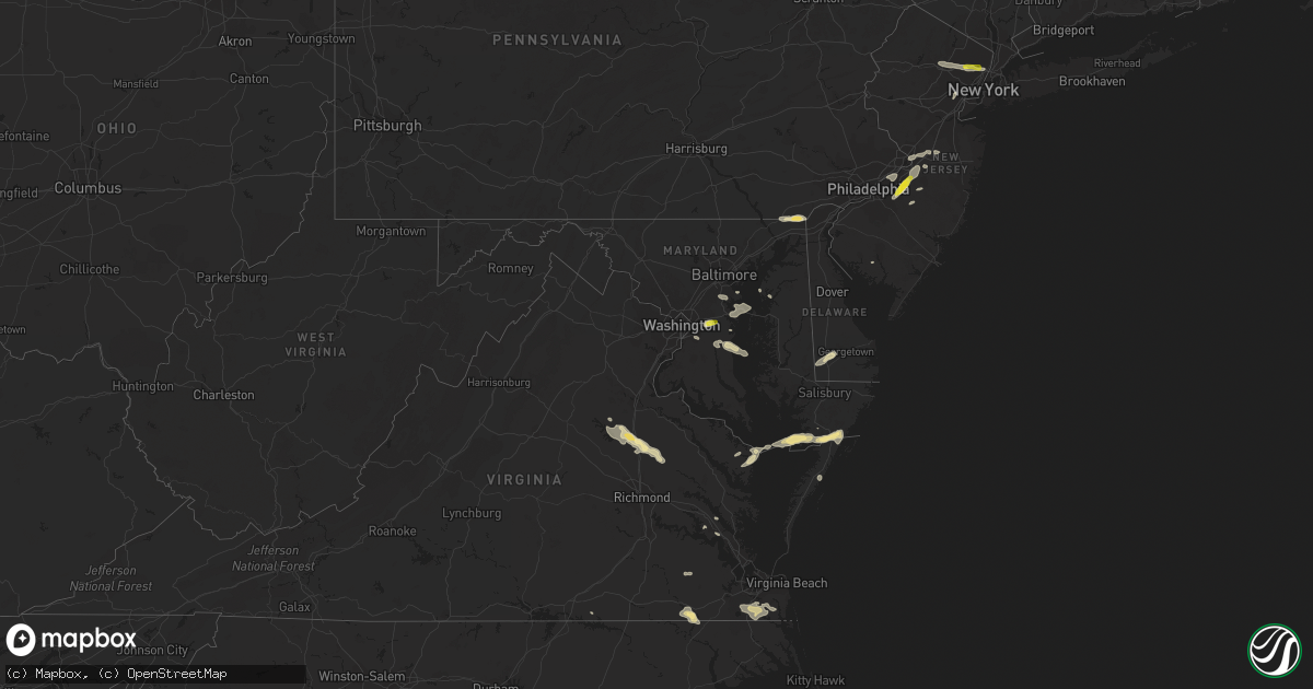
Hail Map in Maryland on July 1, 2016
Get this storm
July 1 map
$229
one time, instant access
Download today. No call, no setup
Keep the $229
Bought the map and want the full workflow? Apply the entire $229 to a subscription within 7 days. None of it is wasted.
Every map, not just this one
This buys you this map. Subscription and you get every map we run, in the markets you choose from a few cities to whole states to nationwide. Plus real-time alerts the moment a storm fires.
Contact data
Name, contact info, occupancy, even credit band for addresses in the footprint. You go from where it hit to who to call.
Become the source they trust
Unlimited branding weather history reports on demand. You already have the documented answer ready for the property owner, and you are the one who showed up with it.
Property data and RoofTrace estimates
Pull up any address you have got, its value and the exact code rules for that jurisdiction, straight from One Click Code. Then RoofTrace estimates the squares, pitch, and roof value, priced the way you price.
Storm reports in Maryland
Maryland
| Date | Description |
|---|---|
| 07/01/20165:24 PM CDT | A local report indicates 1.00 inch wind near 1 SSE BOWIE |
| 07/01/20164:54 PM CDT | Trees down at intersection of garland and mountain road |
| 07/01/20164:51 PM CDT | Trees down at the intersection of woods road and 11th street |
| 07/01/20164:46 PM CDT | Trees down at intersection of truck house road and swaying oak court |
| 07/01/20164:43 PM CDT | Trees down at the intersection of catherine ave and harlem ave |
| 07/01/20163:35 PM CDT | Numerous trees down. Power lines downed also. |
| 07/01/201610:01 AM CDT | Numerous trees and power lines down around crisfield. |
| 07/01/20169:59 AM CDT | Crisfield coast guard station |
| 06/30/20169:42 PM CDT | Tree down on power lines at walnut ave and birch ave |
All States Impacted by Hail Map on July 1, 2016
Cities Impacted by Hail Map on July 1, 2016
- Haswell, CO
- Shawnee, WY
- Arlington, VT
- Shushan, NY
- Clifton, NJ
- Passaic, NJ
- Wayne, NJ
- Totowa, NJ
- Little Falls, NJ
- Friendship, MD
- North Beach, MD
- Tracys Landing, MD
- Las Animas, CO
- La Junta, CO
- Georgetown, DE
- Seaford, DE
- Perryton, TX
- Rexford, NY
- Mechanicville, NY
- Clifton Park, NY
- Round Lake, NY
- Schenectady, NY
- Heathsville, VA
- Reedville, VA
- New River, AZ
- Richfield, KS
- Chesapeake, VA
- New Church, VA
- Pocomoke City, MD
- Hinkley, CA
- White Plains, VA
- Yucca, AZ
- Bullhead City, AZ
- Oxford, PA
- Owings, MD
- Dunkirk, MD
- Larned, KS
- Kinsley, KS
- Garfield, KS
- Elkton, MD
- Lincoln University, PA
- Landenberg, PA
- Rising Sun, MD
- Nottingham, PA
- Sedalia, CO
- Franktown, CO
- Castle Rock, CO
- Hainesport, NJ
- Lumberton, NJ
- Mount Holly, NJ
- Medford, NJ
- Manter, KS
- Peyton, CO
- Barstow, CA
- Two Buttes, CO
- Springfield, CO
- Poughkeepsie, NY
- Wappingers Falls, NY
- Chesapeake Beach, MD
- Wellton, AZ
- Stockton, MD
- Marion Station, MD
- Overton, NV
- Saugerties, NY
- Malden On Hudson, NY
- Crawford, NE
- Oviedo, FL
- Rock Hall, MD
- Manchester Center, VT
- Merritt Island, FL
- Colorado Springs, CO
- Phoenix, AZ
- Clermont, FL
- Accomac, VA
- Lambert, MT
- Wingdale, NY
- Dover Plains, NY
- Christmas, FL
- Orlando, FL
- Carter, OK
- Walsh, CO
- Buckeye, AZ
- Walden, NY
- Montgomery, NY
- Upper Marlboro, MD
- Lothian, MD
- Harrison, NE
- Pemberton, NJ
- Browns Mills, NJ
- Burgess, VA
- Bowie, MD
- Elizabeth, CO
- Bechtelsville, PA
- Boyertown, PA
- Pasadena, MD
- Glen Burnie, MD
- Millersville, MD
- Severn, MD
- Severna Park, MD
- Suffolk, VA
- Gates, NC
- Franklin, VA
- Como, NC
- Cambridge, NY
- Manchester, VT
- Texhoma, OK
- Schaghticoke, NY
- Ballston Lake, NY
- Waterford, NY
- Melrose, NY
- Lost Springs, WY
- Burnt Hills, NY
- Milton, NY
- Pleasant Valley, NY
- Marlboro, NY
- Lagrangeville, NY
- Vilas, CO
- Rye, CO
- Pueblo, CO
- Avondale, CO
- Lewis, KS
- Trenton, NJ
- Allentown, NJ
- Chesterfield, NJ
- Spotsylvania, VA
- Johnson, KS
- Clarksville, AR
- Gillette, WY
- Riverside, NJ
- Willingboro, NJ
- Beverly, NJ
- Burlington, NJ
- Campo, CO
- Lamar, CO
- Verbank, NY
- Poughquag, NY
- Gardiner, NY
- Highland, NY
- Hopewell Junction, NY
- Modena, NY
- Wallkill, NY
- Beaverdam, VA
- Ruther Glen, VA
- Harwood, MD
- Crisfield, MD
- Willow, OK
- Granite, OK
- Burdett, KS
- Newark, DE
- Otis, CO
- Akron, CO
- Lucerne Valley, CA
- Montville, NJ
- Boonton, NJ
- Millstone Township, NJ
- Brockton, MT
- Partlow, VA
- Aylett, VA
- Woodford, VA
- Williamsburg, VA
- Newsoms, VA
- Courtland, VA
- Rockledge, FL
- Melbourne, FL
- Marlton, NJ
- Suitland, MD
- Temple Hills, MD
- Andrews Air Force Base, MD
- Gibson Island, MD
- Arnold, MD
- Annapolis, MD
- Edgewater, MD
- Elkhart, KS
- Young, AZ
- Bumpass, VA
- Doswell, VA
- Milford, VA
- Canute, OK
- Elk City, OK
- Butler, OK
- Columbus, NJ
- Vincentown, NJ
- Bordentown, NJ
- Jobstown, NJ
- Mount Laurel, NJ
- Onley, VA
- Windsor, NJ
- Hightstown, NJ
- Robbinsville, NJ
- Helendale, CA
- Adelanto, CA
- Oro Grande, CA
- Chestertown, MD
- Cave Creek, AZ
- Ash Fork, AZ
- Granada, CO
- Roosevelt, NJ
- Arlington, CO
- Oark, AR
- Ozone, AR
- Kiowa, CO
- Ewell, MD
- Kenilworth, NJ
- Union, NJ
- Cranford, NJ
- Bethel, DE
- Hialeah, FL
- Lancaster, VA
- Germantown, NY
- Tivoli, NY
- Colorado City, CO
- Horntown, VA
- Oak Hall, VA
- Greenbackville, VA
- Virginia Beach, VA
- Ivor, VA
- Wakefield, VA
- Cape Canaveral, FL
- Patrick Afb, FL
- Westfield, NJ
- Bunnell, FL
- Big Bear City, CA
- Ordway, CO
- Albany, NY
- Catskill, NY
- Fayetteville, AR
- Paterson, NJ
- Caldwell, NJ
- Teterboro, NJ
- Wood Ridge, NJ
- Elmwood Park, NJ
- Lodi, NJ
- Mountain Lakes, NJ
- South Hackensack, NJ
- Hasbrouck Heights, NJ
- Cedar Grove, NJ
- Garfield, NJ
- Teaneck, NJ
- Saddle Brook, NJ
- Wallington, NJ
- Denville, NJ
- Lake Hiawatha, NJ
- Montclair, NJ
- Pine Brook, NJ
- Bogota, NJ
- Hackensack, NJ
- Fairfield, NJ
- Lincoln Park, NJ
- Towaco, NJ
- Leonia, NJ
- Ridgefield Park, NJ
- Goodyear, AZ
- East Arlington, VT
- Chester, VT
- Weston, VT
- Londonderry, VT
- Peru, VT
- Woodstock, NY
- Newberry Springs, CA
- Millville, NJ
- New Milford, CT
- New Fairfield, CT
- Garysburg, NC
- Heber, AZ
- Bondville, VT
- Johnsonville, NY
- Stillwater, NY
- Greenwich, NY
- Valley Falls, NY
- Rochelle Park, NJ
- Maywood, NJ


