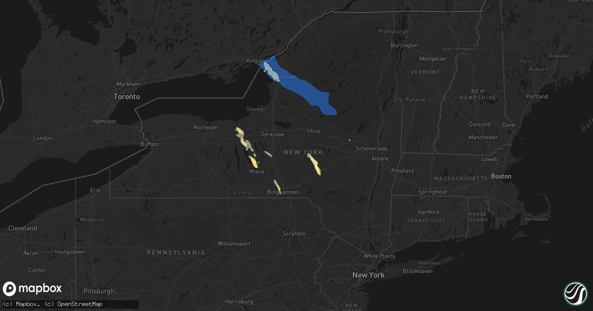
Hail Map in New York on June 30, 2026
Get this storm
June 30 map
$229
one time, instant access
Download today. No call, no setup
Keep the $229
Bought the map and want the full workflow? Apply the entire $229 to a subscription within 7 days. None of it is wasted.
Every map, not just this one
This buys you this map. Subscription and you get every map we run, in the markets you choose from a few cities to whole states to nationwide. Plus real-time alerts the moment a storm fires.
Contact data
Name, contact info, occupancy, even credit band for addresses in the footprint. You go from where it hit to who to call.
Become the source they trust
Unlimited branding weather history reports on demand. You already have the documented answer ready for the property owner, and you are the one who showed up with it.
Property data and RoofTrace estimates
Pull up any address you have got, its value and the exact code rules for that jurisdiction, straight from One Click Code. Then RoofTrace estimates the squares, pitch, and roof value, priced the way you price.
Storm reports in New York
New York
| Date | Description |
|---|---|
| 06/30/20266:33 PM CDT | A local report indicates 1.00 inch wind near Maine |
| 06/30/20265:15 PM CDT | Trees and wires down in the hillsdale village near route 23. |
| 06/30/20265:10 PM CDT | Multiple trees down in downsville. |
| 06/30/20264:55 PM CDT | Several reports of trees and wires down across chatham. |
| 06/30/20264:55 PM CDT | Trees and wires down in the city of hudson. |
| 06/30/20264:28 PM CDT | Report of a tree down in castleton. |
| 06/30/20264:23 PM CDT | Trees and wires down in biechman road. |
| 06/30/20264:20 PM CDT | Report of trees down in selkirk near beaver dam road and maple road. Time estimated from radar. |
| 06/30/20264:10 PM CDT | Report of tree down on wires on oak hill rd in poestenkill. |
| 06/30/20264:09 PM CDT | From pictures sent via social media. |
| 06/30/20264:09 PM CDT | Hail reported with a couple of estimated golf ball sized stones mixed in. |
| 06/30/20264:07 PM CDT | Quarter to golf size hail. |
| 06/30/20263:58 PM CDT | Report of tree down on road at intersection of brunswick rd and shyne rd. |
| 06/30/20263:51 PM CDT | Trees down near county route 10. |
| 06/30/20263:51 PM CDT | Several trees down near county route 10. |
| 06/30/20263:44 PM CDT | Report of trees down on clamsteam rd in halfmoon. |
| 06/30/20263:40 PM CDT | Multiple trees and wires down with vehicles caught in between. |
| 06/30/20263:22 PM CDT | Downed pole and wires on ny 159 between levey road and mariaville scotch church road. |
| 06/30/20263:02 PM CDT | Social media report of tree down in roadway on south pawling st at northern blvd. |
| 06/30/20263:00 PM CDT | Numerous downed trees and wires down closing all of martin road... Between hickory hill road and state highway 5. |
| 06/30/20262:59 PM CDT | Trees down in the perth area. |
| 06/30/20262:59 PM CDT | Trees down in the perth area. |
| 06/30/20262:57 PM CDT | Report of tree down on wires blocking the roadway on route 30a in the town of glen. |
| 06/30/20262:57 PM CDT | 4 large tree downs and a shed blown over. |
| 06/30/20262:54 PM CDT | Social media report of widespread trees and wires down on route 5s west of fultonville... Ny. |
| 06/30/20262:49 PM CDT | Several trees down in the johnstown area. |
| 06/30/20262:48 PM CDT | Downed trees and wires closing all lanes of hickory hill road... Between martin road and gunnerson lane. |
| 06/30/20262:47 PM CDT | Several trees down in the gloversville area. |
| 06/30/20262:45 PM CDT | Social media report of tree down across the roadway on ny route 334. |
| 06/30/20262:42 PM CDT | Numerous trees and wires down closing all lanes of stone arabia road... Between martin road and barker road. |
| 06/30/20262:18 PM CDT | Trees down in the stratford area. |
| 06/30/20262:17 PM CDT | Report of tree down on wires on graves rd in newport... Ny. |
| 06/30/20262:07 PM CDT | Report of tree down on old piseco rd. |
| 06/30/20262:05 PM CDT | Tree and wires down; utility pole sheared in half and under the debris. |
| 06/30/20261:50 PM CDT | Report of tree down on wheelertown rd in russia... Ny. |
| 06/30/20261:44 PM CDT | Report of trees down on south shore rd in the town of webb. |
| 06/30/20261:43 PM CDT | Tree down on highway 31. |
| 06/30/20261:37 PM CDT | Report of tree down on car at water safari in old forge. |
| 06/30/20261:36 PM CDT | Report of tree down on wires on william st in the town of webb. |
| 06/30/20261:03 PM CDT | Multiple trees... Large branches... And wires down. |
| 06/30/202612:53 PM CDT | Delayed report. Report from emergency manager of numerous trees downed across castorland. Time estimated by radar. |
| 06/30/202612:41 PM CDT | Large tree branch down. |
| 06/29/202610:53 PM CDT | Report of a few trees and wires downed in the town of champion. |
| 06/29/202610:25 PM CDT | Report of trees down in potsdam. Time estimated by radar. |
| 06/29/202610:05 PM CDT | Trees and wires in road. Time estimated by radar. |
| 06/29/20269:55 PM CDT | Tree down across state highway 812. Time estimated by radar. |
All States Impacted by Hail Map on June 30, 2026
Cities Impacted by Hail Map on June 30, 2026
- Arcadia, WI
- Independence, WI
- Fountain City, WI
- Cochrane, WI
- Blair, WI
- Whitehall, WI
- Alma, WI
- Black River Falls, WI
- Sparta, WI
- Norwalk, WI
- Osseo, WI
- Tomah, WI
- Warrens, WI
- Pittsville, WI
- Granton, WI
- Vesper, WI
- Arpin, WI
- Wisconsin Rapids, WI
- Plainfield, WI
- Wild Rose, WI
- Almond, WI
- Waupaca, WI
- Weyauwega, WI
- Rudolph, WI
- Junction City, WI
- Hortonville, WI
- New London, WI
- Shiocton, WI
- Clayton, NY
- Cape Vincent, NY
- Chaumont, NY
- Three Mile Bay, NY
- Wimauma, FL
- Ocoee, FL
- Apopka, FL
- La Fargeville, NY
- Depauville, NY
- Dexter, NY
- Watertown, NY
- Evans Mills, NY
- Sackets Harbor, NY
- Brownville, NY
- Calcium, NY
- Orlando, FL
- Lithia, FL
- Brooksville, FL
- Adams Center, NY
- Fort Drum, NY
- Black River, NY
- Rodman, NY
- Copenhagen, NY
- Carthage, NY
- Felts Mills, NY
- Lorraine, NY
- Wytheville, VA
- Polk City, FL
- Lowville, NY
- Castorland, NY
- Apalachicola, FL
- Paradise, MI
- Glenfield, NY
- Turin, NY
- Constableville, NY
- Croghan, NY
- Lyons Falls, NY
- Greig, NY
- Brantingham, NY
- Boonville, NY
- Port Leyden, NY
- Winter Haven, FL
- Haines City, FL
- Lake Hamilton, FL
- Dundee, FL
- Davenport, FL
- Eagle Bay, NY
- Woodgate, NY
- Forestport, NY
- Old Forge, NY
- Thendara, NY
- Port Saint Joe, FL
- Leesburg, FL
- Lady Lake, FL
- Fruitland Park, FL
- The Villages, FL
- Cold Brook, NY
- Port Charlotte, FL
- Clyde, NY
- Lyons, NY
- Hoffmeister, NY
- Savannah, NY
- North Port, FL
- Amherst, MA
- Inglis, FL
- Cayuga, NY
- Auburn, NY
- Williston, FL
- Bronson, FL
- Seneca Falls, NY
- Waterloo, NY
- Homer, NY
- Clayton, NM
- Union Springs, NY
- Scipio Center, NY
- Saint Cloud, FL
- Stratford, WI
- Marshfield, WI
- Fonda, NY
- Auburndale, WI
- Lakeview, TX
- New Berlin, NY
- Edgar, WI
- Mosinee, WI
- Aurora, NY
- Grenville, NM
- Edmeston, NY
- Sherburne, NY
- West Edmeston, NY
- Old Town, FL
- Kenton, OK
- Chiefland, FL
- Marathon, WI
- Mount Vision, NY
- Garrattsville, NY
- New Lisbon, NY
- Morris, NY
- King Ferry, NY
- Clarendon, TX
- Genoa, NY
- Eland, WI
- Trenton, FL
- Perry, FL
- West Oneonta, NY
- Laurens, NY
- Otego, NY
- Lansing, NY
- Locke, NY
- Groton, NY
- Mclean, TX
- Wausau, WI
- Brokaw, WI
- Birnamwood, WI
- Antigo, WI
- Okeechobee, FL
- Merrill, WI
- Oneonta, NY
- Boise City, OK
- Wittenberg, WI
- Tigerton, WI
- Ithaca, NY
- Mattoon, WI
- Franklin, NY
- Freeville, NY
- Bowler, WI
- Hatley, WI
- Gruver, TX
- Little York, NY
- Moravia, NY
- Mountain, WI
- Gleason, WI
- Lakewood, WI
- Spearman, TX
- Walsh, CO
- Two Buttes, CO
- Lelia Lake, TX
- Naples, FL
- Springfield, CO
- Vilas, CO
- Campo, CO
- Panacea, FL
- Hedley, TX
- Granada, CO
- Felda, FL
- Athelstane, WI
- Morton, TX
- Clintonville, WI
- Amberg, WI
- Leopolis, WI
- Shawano, WI
- Gresham, WI
- Syracuse, KS
- Holly, CO
- Pembine, WI
- Niagara, WI
- Dunbar, WI
- Bonduel, WI
- Sopchoppy, FL
- Wallace, KS
- Rock, MI
- Coolidge, KS
- Claude, TX
- Sobieski, WI
- Pulaski, WI
- Cecil, WI
- Krakow, WI
- Seymour, WI
- Black Creek, WI
- Jay, FL
- Sayre, OK
- Quincy, FL
- De Pere, WI
- Newark Valley, NY
- Lisle, NY
- Berkshire, NY
- Trenary, MI
- Skandia, MI
- Little Suamico, WI
- Abrams, WI
- Sharon Springs, KS
- Oconto Falls, WI
- Green Bay, WI
- Suamico, WI
- Oneida, WI
- McDavid, FL
- Tribune, KS
- Muleshoe, TX
- Bristol, FL
- Blountstown, FL
- Erick, OK
- Reydon, OK
- Cheyenne, OK
- Sweetwater, OK
- Manter, KS
- Kendall, KS
- Leoti, KS
- Lakin, KS
- Eben Junction, MI
- Chatham, MI
- Rumely, MI
- Bay Minette, AL
- Elkhart, KS
- Rapid River, MI
- Maine, NY
- Endicott, NY
- Johnson City, NY
- Ochopee, FL
- Johnson, KS
- Happy, TX
- Tulia, TX
- Deerton, MI
- Altha, FL
- Clarksville, FL
- Au Train, MI
- Notasulga, AL
- Kaukauna, WI
- Ulysses, KS
- Glen Aubrey, NY
- Flagler, CO
- Irvington, AL
- Deerfield, KS
- Vestal, NY
- Luxemburg, WI
- New Franken, WI
- Grand Bay, AL
- Mobile, AL
- Wetmore, MI
- Seibert, CO
- Vona, CO
- Winona, KS
- Theodore, AL
- Arden, NC
- Munising, MI
- Tuskegee, AL
- Forestville, WI
- Casco, WI
- Binghamton, NY
- Canyon, TX
- Fountain, FL
- Alford, FL
- Milnesand, NM
- Marathon, TX
- Forest Home, AL
- Ozark, AL
- Marianna, FL
- Holcomb, KS
- Causey, NM
- Denmark, WI
- Kewaunee, WI
- Joes, CO
- Edson, KS
- Oakley, KS
- Scott City, KS
- Marienthal, KS
- New Brockton, AL
- Enterprise, AL
- Georgiana, AL
- Moss Point, MS
- Evergreen, AL
- Pine Apple, AL
- Grinnell, KS
- Colby, KS
- Monument, KS
- Gove, KS
- Garden City, KS
- Burlington, CO
- Briggsdale, CO
- Fort Morgan, CO
- Stratton, CO
- Bethune, CO
- Stoneham, CO
- New Raymer, CO
- Idalia, CO
- Montgomery, AL
- Levelland, TX
- Healy, KS
- Hoxie, KS
- Rexford, KS
- Rogers City, MI
- Fieldton, TX
- Amherst, TX
- Littlefield, TX
- Beeler, KS
- Dighton, KS
- Grover, CO
- Sterling, CO
- Merino, CO
- Gainestown, AL
- Grainfield, KS
- Levant, KS
- Selden, KS
- Gem, KS
- Pyote, TX
- Ropesville, TX
- Manistee, MI
- Fleming, CO
- Padroni, CO
- Peetz, CO
- Iliff, CO
- Kirk, CO
- Park, KS
- Penokee, KS
- Morland, KS
- Dresden, KS
- Quinter, KS
- Clayton, KS
- Hill City, KS
- Jennings, KS
- Collyer, KS
- Wakeeney, KS
- Lenora, KS
- Anton, TX
- Essex, IA
- Ludington, MI
- Grove Hill, AL
- Whatley, AL
- Olton, TX
- Springlake, TX
- Dimmitt, TX
- Hart, TX
- Earth, TX
- Ness City, KS
- Utica, KS
- Ransom, KS
- Arnold, KS
- Nazareth, TX
- Crook, CO
- Sidney, NE
- Palco, KS
- Ogallah, KS
- Ellis, KS
- Brownell, KS
- Bazine, KS
- Bogue, KS
- Lubbock, TX
- Ramer, AL
- McCracken, KS
- Hays, KS
- Scottville, MI
- Red Oak, IA
- Norton, KS
- Alexander, KS
- La Crosse, KS
- Schoenchen, KS
- Liebenthal, KS
- Nekoma, KS
- Rush Center, KS
- Sedgwick, CO
- Lodgepole, NE
- Almena, KS
- Shallowater, TX
- Youngstown, FL
- Chappell, NE
- Victoria, KS
- Bison, KS
- Logan, KS
- Prairie View, KS
- Stockton, KS
- Wolfforth, TX
- Slaton, TX
- Wilson, TX
- Imogene, IA
- Highland Home, AL
- Letohatchee, AL
- Hope Hull, AL
- Ovid, CO
- Shenandoah, IA
- Gorham, KS
- Pfeifer, KS
- Walker, KS
- Russell, KS
- Otis, KS
- Bunker Hill, KS
- Hoisington, KS
- Olmitz, KS
- Albert, KS
- Paradise, KS
- Julesburg, CO
- Oshkosh, NE
- Lewellen, NE
- Big Springs, NE
- Venango, NE
- Brule, NE
- Emerson, IA
- Grant, NE
- Ogallala, NE
- Lemoyne, NE
- Arthur, NE
- Holyoke, CO
- Malvern, IA
- Hastings, IA
- Keystone, NE
- Paxton, NE
- Amherst, CO
- Whitman, NE
- Hyannis, NE
- Tryon, NE
- Mullen, NE
- Sutherland, NE
- Champion, NE
- Haxtun, CO
- Atwood, CO
- Henderson, IA
- Silver City, IA
- Macedonia, IA
- Seneca, NE
- Thedford, NE
- Stapleton, NE
- Valentine, NE
- Johnstown, NE
- Carson, IA
- Ainsworth, NE
- Long Pine, NE
- Enders, NE
- Halsey, NE
- Purdum, NE
- Dunning, NE
- Arnold, NE
- Callaway, NE
- Elsmere, NE
- Wood Lake, NE
- Onawa, IA
- Wauneta, NE
- Hayes Center, NE
- Elsie, NE
- Whiting, IA
- Bassett, NE
- Springview, NE
- Mills, NE
- Ewing, NE
- Hornick, IA
- Castana, IA
- Smithland, IA
- Rodney, IA
- Chambers, NE
- Anthon, IA
- Oto, IA
- Naper, NE
- Bronson, IA
- Salix, IA
- Sloan, IA
- Wallace, NE
- Dickens, NE
- Neligh, NE
- Clearwater, NE
- Inman, NE
- Moville, IA
- Brunswick, NE
- Herrick, SD
- Lawton, IA
- Kingsley, IA
- Pierson, IA
- Climbing Hill, IA
- Royal, NE
- Gregory, SD
- Bonesteel, SD
- Pierce, NE
- Osmond, NE
- Taylor, NE
- Brewster, NE
- Anselmo, NE
- Atkinson, NE
- Fairfax, SD
- Burke, SD
- Hinton, IA
- Wellfleet, NE
- Creighton, NE
- Winnetoon, NE
- Stuart, NE
- Burwell, NE
- Newport, NE
- Dallas, SD
- Colome, SD
- Amelia, NE
- Emmet, NE
- Oneill, NE
- Saint Charles, SD
- Lake Andes, SD
- Wagner, SD
- Pickstown, SD
- Sioux City, IA
- Le Mars, IA
- Merrill, IA
- Magnet, NE
- Randolph, NE
- Hartington, NE
- Coleridge, NE
- Dixon, NE
- Laurel, NE
- Mclean, NE
- Butte, NE
- Bloomfield, NE
- Center, NE
- Crofton, NE
- Yankton, SD
- Tabor, SD
- Saint Helena, NE
- Niobrara, NE
- Lesterville, SD
- Tyndall, SD
- Scotland, SD
- Tripp, SD
- Springfield, SD
- Brunsville, IA
- Akron, IA
- Ireton, IA
- Hawarden, IA
- Aurelia, IA
- Newcastle, NE
- Geddes, SD
- North Platte, NE
- Spencer, NE
- Bristow, NE
- Utica, SD
- Olivet, SD
- Kaylor, SD
- Menno, SD
- Mission Hill, SD
- Sioux Center, IA
- Maurice, IA
- Rock Valley, IA
- Hull, IA
- Hudson, SD
- Alcester, SD
- Maxwell, NE
- Platte, SD
- Wynot, NE
- Orange City, IA
- Inwood, IA
- Rock Rapids, IA
- Doon, IA
- Alvord, IA
- Canton, SD
- Larchwood, IA
- Fairview, SD
- Irene, SD
- Viborg, SD
- Volin, SD
- Freeman, SD
- Emery, SD
- Bridgewater, SD
- Marion, SD
- Hurley, SD
- Oyens, IA
- Remsen, IA
- Melvin, IA
- Everly, IA
- Milford, IA
- Gayville, SD
- Dante, SD
- Avon, SD
- Lynch, NE
- Parkston, SD
- Corsica, SD
- Dimock, SD
- Delmont, SD
- Armour, SD
- Chamberlain, SD
- Pukwana, SD
- Harrison, SD
- Kimball, SD
- Oacoma, SD
- Winner, SD
- Harrisburg, SD
- Parker, SD
- Beresford, SD
- Worthing, SD
- Terril, IA
- Granville, IA
- Mount Vernon, SD
- Spirit Lake, IA
- Lake Park, IA
- Lennox, SD
- Lester, IA
- Sioux Falls, SD
- Tea, SD
- Valley Springs, SD
- Brandon, SD
- Hills, MN
- Stickney, SD
- White Lake, SD
- New Holland, SD
- Mitchell, SD
- Ethan, SD
- Letcher, SD
- Plankinton, SD
- Woonsocket, SD
- Wessington Springs, SD
- Gann Valley, SD
- Decorah, IA
- Calmar, IA
- Paullina, IA
- Fulton, SD
- Alexandria, SD
- Artesian, SD
- Spencer, SD
- Canistota, SD
- Primghar, IA
- Hartley, IA
- Waukon, IA
- Sanborn, IA
- Canova, SD
- Fedora, SD
- Montrose, SD
- Howard, SD
- Ramona, SD
- Salem, SD
- Winfred, SD
- Carthage, SD
- Monroe, SD
- Dell Rapids, SD
- Trent, SD
- Renner, SD
- Egan, SD
- Baltic, SD
- Garretson, SD
- Flandreau, SD
- Colton, SD
- Lyons, SD
- Crooks, SD
- Hartford, SD
- Waterville, IA
- Madison, SD
- Chester, SD
- Wentworth, SD
- Colman, SD
- Rutland, SD
- Chancellor, SD
- Humboldt, SD
- Dickens, IA
- Ledyard, IA
- Swea City, IA
- Fulda, MN
- Lansing, IA
- Estherville, IA
- Elmore, MN
- Buffalo Center, IA
- Thompson, IA
- De Soto, WI
- Ferryville, WI
- Blue Earth, MN
- Granada, MN
- Whittemore, IA
- Cylinder, IA
- Superior, IA
- Jasper, MN
- Alpha, MN
- Viroqua, WI
- Bricelyn, MN
- Winnebago, MN
- Frost, MN
- Scarville, IA
- Kiester, MN
- Emmons, MN
- Lone Rock, IA
- Fenton, IA
- Steen, MN
- Luverne, MN
- Beaver Creek, MN
- Hardwick, MN
- Pipestone, MN
- Okoboji, IA
- Glenville, MN
- Wells, MN
- Alden, MN
- Albert Lea, MN
- New Albin, IA
- Twin Lakes, MN
- Dolliver, IA
- Armstrong, IA
- Fairmont, MN
- Easton, MN
- Ellsworth, MN
- Magnolia, MN
- Kanaranzi, MN
- Adrian, MN
- Nunda, SD
- Lakota, IA
- Viola, WI
- Clarks Grove, MN
- Truman, MN
- Bancroft, IA
- Titonka, IA
- Hollandale, MN
- Ellendale, MN
- Hayward, MN
- Hartland, MN
- Readstown, WI
- Brownsville, MN
- Caledonia, MN
- Spring Grove, MN
- Austin, MN
- Genoa, WI
- Ceylon, MN
- New Richland, MN
- Minnesota Lake, MN
- Delavan, MN
- La Farge, WI
- Lansing, MN
- Stoddard, WI
- Hillsboro, WI
- Brownsdale, MN
- Waltham, MN
- Sargeant, MN
- Alton, IA
- Fort Thompson, SD
- Brady, NE
- Elroy, WI
- Blooming Prairie, MN
- Lanesboro, MN
- Hayfield, MN
- Spring Valley, MN
- Racine, MN
- Geneva, MN
- Wonewoc, WI
- Kendall, WI
- Mauston, WI
- New Lisbon, WI
- Camp Douglas, WI
- Adams, WI
- Wisconsin Dells, WI
- Grand Marsh, WI
- Friendship, WI
- Stewartville, MN
- Peterson, MN
- La Valle, WI
- Chatfield, MN
- Necedah, WI
- Heron Lake, MN
- Houston, MN
- Winona, MN
- Wykoff, MN
- Rushford, MN
- Dakota, MN
- Dexter, MN
- Elkton, MN
- Adams, MN
- Lyle, MN
- Rose Creek, MN
- Conger, MN
- Dunnell, MN
- Jackson, MN
- Lewiston, MN
- Saint Charles, MN
- Dover, MN
- Arkdale, WI
- Coloma, WI
- Oxford, WI
- Westfield, WI
- Neshkoro, WI
- Wautoma, WI
- Hancock, WI
- Montello, WI
- Utica, MN
- Altura, MN
- Portage, WI
- Lake Mills, IA
- Freeborn, MN
- Grand Meadow, MN
- Pine River, WI
- Fremont, WI
- Poy Sippi, WI
- Redgranite, WI
- Berlin, WI
- Northwood, IA
- Pardeeville, WI


