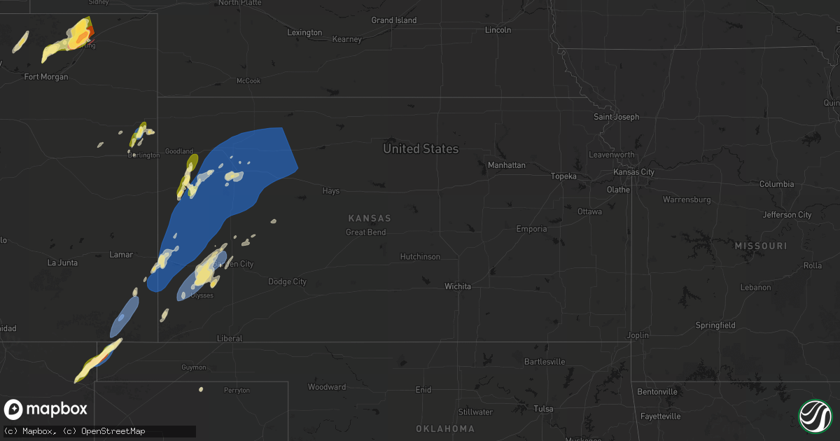
Hail Map in Kansas on June 30, 2026
Get this storm
June 30 map
$229
one time, instant access
Download today. No call, no setup
Keep the $229
Bought the map and want the full workflow? Apply the entire $229 to a subscription within 7 days. None of it is wasted.
Every map, not just this one
This buys you this map. Subscription and you get every map we run, in the markets you choose from a few cities to whole states to nationwide. Plus real-time alerts the moment a storm fires.
Contact data
Name, contact info, occupancy, even credit band for addresses in the footprint. You go from where it hit to who to call.
Become the source they trust
Unlimited branding weather history reports on demand. You already have the documented answer ready for the property owner, and you are the one who showed up with it.
Property data and RoofTrace estimates
Pull up any address you have got, its value and the exact code rules for that jurisdiction, straight from One Click Code. Then RoofTrace estimates the squares, pitch, and roof value, priced the way you price.
Storm reports in Kansas
Kansas
| Date | Description |
|---|---|
| 06/30/20266:59 PM CDT | A local report indicates 65 MPH wind near Lakin |
| 06/30/20266:58 PM CDT | A local report indicates 59 MPH wind near 10 S Kendall |
| 06/30/20266:57 PM CDT | A local report indicates 59 MPH wind near 22 NNW Lakin |
| 06/30/20266:54 PM CDT | Site aero b ranch measured a 70 mph wind gust. |
| 06/30/20266:52 PM CDT | Awos station k3k7 leoti airport. |
| 06/30/20266:48 PM CDT | Picture of a porta-potty laying on its side; time estimated from radar. |
| 06/30/20266:48 PM CDT | Picture of a large downed tree limb; time estimated from radar. |
| 06/30/20266:48 PM CDT | 3 pictures of large tree limbs down; time estimated from radar. |
| 06/30/20266:47 PM CDT | Em relayed report of measured 81 mph wind gust with sustained winds around 64 mph. |
| 06/30/20266:31 PM CDT | Site 8 nne tribune measured 58 mph gust. |
| 06/30/20266:17 PM CDT | Corrects previous tstm wnd gst report from 1 s tribune. Ktrb measured 58 mph gust. |
| 06/30/20266:15 PM CDT | Awos station k3k3 syracuse. |
| 06/29/202610:09 PM CDT | A local report indicates 60 MPH wind near 5 NE Lucas |
| 06/29/20269:51 PM CDT | A local report indicates 61 MPH wind near 1 SSW Russell |
| 06/29/20269:42 PM CDT | A local report indicates 64 MPH wind near Russell Airport |
| 06/29/20269:17 PM CDT | A local report indicates 66 MPH wind near 1 N Liebenthal |
| 06/29/20269:13 PM CDT | A local report indicates 73 MPH wind near 1 ESE Hargrave |
| 06/29/20268:28 PM CDT | Site six toes feed & seed measured 59 mph wind gust. |
| 06/29/20268:28 PM CDT | Davis site; six toes feed and seed. |
| 06/29/20268:24 PM CDT | Site kkscolby59 measured 62 mph wind gust. |
| 06/29/20268:09 PM CDT | Up830. |
| 06/29/20268:09 PM CDT | Public report west of gove. |
| 06/29/20268:01 PM CDT | Site wpe weather measured 62 mph wind gust. |
| 06/29/20267:14 PM CDT | Tin blown off the top of a shed. |
| 06/29/20267:00 PM CDT | Weather underground; aero b ranch - kkswalla4. |
All States Impacted by Hail Map on June 30, 2026
Cities Impacted by Hail Map on June 30, 2026
- Arcadia, WI
- Independence, WI
- Fountain City, WI
- Cochrane, WI
- Blair, WI
- Whitehall, WI
- Alma, WI
- Black River Falls, WI
- Sparta, WI
- Norwalk, WI
- Osseo, WI
- Tomah, WI
- Warrens, WI
- Pittsville, WI
- Granton, WI
- Vesper, WI
- Arpin, WI
- Wisconsin Rapids, WI
- Plainfield, WI
- Wild Rose, WI
- Almond, WI
- Waupaca, WI
- Weyauwega, WI
- Rudolph, WI
- Junction City, WI
- Hortonville, WI
- New London, WI
- Shiocton, WI
- Clayton, NY
- Cape Vincent, NY
- Chaumont, NY
- Three Mile Bay, NY
- Wimauma, FL
- Ocoee, FL
- Apopka, FL
- La Fargeville, NY
- Depauville, NY
- Dexter, NY
- Watertown, NY
- Evans Mills, NY
- Sackets Harbor, NY
- Brownville, NY
- Calcium, NY
- Orlando, FL
- Lithia, FL
- Brooksville, FL
- Adams Center, NY
- Fort Drum, NY
- Black River, NY
- Rodman, NY
- Copenhagen, NY
- Carthage, NY
- Felts Mills, NY
- Lorraine, NY
- Wytheville, VA
- Polk City, FL
- Lowville, NY
- Castorland, NY
- Apalachicola, FL
- Paradise, MI
- Glenfield, NY
- Turin, NY
- Constableville, NY
- Croghan, NY
- Lyons Falls, NY
- Greig, NY
- Brantingham, NY
- Boonville, NY
- Port Leyden, NY
- Winter Haven, FL
- Haines City, FL
- Lake Hamilton, FL
- Dundee, FL
- Davenport, FL
- Eagle Bay, NY
- Woodgate, NY
- Forestport, NY
- Old Forge, NY
- Thendara, NY
- Port Saint Joe, FL
- Leesburg, FL
- Lady Lake, FL
- Fruitland Park, FL
- The Villages, FL
- Cold Brook, NY
- Port Charlotte, FL
- Clyde, NY
- Lyons, NY
- Hoffmeister, NY
- Savannah, NY
- North Port, FL
- Amherst, MA
- Inglis, FL
- Cayuga, NY
- Auburn, NY
- Williston, FL
- Bronson, FL
- Seneca Falls, NY
- Waterloo, NY
- Homer, NY
- Clayton, NM
- Union Springs, NY
- Scipio Center, NY
- Saint Cloud, FL
- Stratford, WI
- Marshfield, WI
- Fonda, NY
- Auburndale, WI
- Lakeview, TX
- New Berlin, NY
- Edgar, WI
- Mosinee, WI
- Aurora, NY
- Grenville, NM
- Edmeston, NY
- Sherburne, NY
- West Edmeston, NY
- Old Town, FL
- Kenton, OK
- Chiefland, FL
- Marathon, WI
- Mount Vision, NY
- Garrattsville, NY
- New Lisbon, NY
- Morris, NY
- King Ferry, NY
- Clarendon, TX
- Genoa, NY
- Eland, WI
- Trenton, FL
- Perry, FL
- West Oneonta, NY
- Laurens, NY
- Otego, NY
- Lansing, NY
- Locke, NY
- Groton, NY
- Mclean, TX
- Wausau, WI
- Brokaw, WI
- Birnamwood, WI
- Antigo, WI
- Okeechobee, FL
- Merrill, WI
- Oneonta, NY
- Boise City, OK
- Wittenberg, WI
- Tigerton, WI
- Ithaca, NY
- Mattoon, WI
- Franklin, NY
- Freeville, NY
- Bowler, WI
- Hatley, WI
- Gruver, TX
- Little York, NY
- Moravia, NY
- Mountain, WI
- Gleason, WI
- Lakewood, WI
- Spearman, TX
- Walsh, CO
- Two Buttes, CO
- Lelia Lake, TX
- Naples, FL
- Springfield, CO
- Vilas, CO
- Campo, CO
- Panacea, FL
- Hedley, TX
- Granada, CO
- Felda, FL
- Athelstane, WI
- Morton, TX
- Clintonville, WI
- Amberg, WI
- Leopolis, WI
- Shawano, WI
- Gresham, WI
- Syracuse, KS
- Holly, CO
- Pembine, WI
- Niagara, WI
- Dunbar, WI
- Bonduel, WI
- Sopchoppy, FL
- Wallace, KS
- Rock, MI
- Coolidge, KS
- Claude, TX
- Sobieski, WI
- Pulaski, WI
- Cecil, WI
- Krakow, WI
- Seymour, WI
- Black Creek, WI
- Jay, FL
- Sayre, OK
- Quincy, FL
- De Pere, WI
- Newark Valley, NY
- Lisle, NY
- Berkshire, NY
- Trenary, MI
- Skandia, MI
- Little Suamico, WI
- Abrams, WI
- Sharon Springs, KS
- Oconto Falls, WI
- Green Bay, WI
- Suamico, WI
- Oneida, WI
- McDavid, FL
- Tribune, KS
- Muleshoe, TX
- Bristol, FL
- Blountstown, FL
- Erick, OK
- Reydon, OK
- Cheyenne, OK
- Sweetwater, OK
- Manter, KS
- Kendall, KS
- Leoti, KS
- Lakin, KS
- Eben Junction, MI
- Chatham, MI
- Rumely, MI
- Bay Minette, AL
- Elkhart, KS
- Rapid River, MI
- Maine, NY
- Endicott, NY
- Johnson City, NY
- Ochopee, FL
- Johnson, KS
- Happy, TX
- Tulia, TX
- Deerton, MI
- Altha, FL
- Clarksville, FL
- Au Train, MI
- Notasulga, AL
- Kaukauna, WI
- Ulysses, KS
- Glen Aubrey, NY
- Flagler, CO
- Irvington, AL
- Deerfield, KS
- Vestal, NY
- Luxemburg, WI
- New Franken, WI
- Grand Bay, AL
- Mobile, AL
- Wetmore, MI
- Seibert, CO
- Vona, CO
- Winona, KS
- Theodore, AL
- Arden, NC
- Munising, MI
- Tuskegee, AL
- Forestville, WI
- Casco, WI
- Binghamton, NY
- Canyon, TX
- Fountain, FL
- Alford, FL
- Milnesand, NM
- Marathon, TX
- Forest Home, AL
- Ozark, AL
- Marianna, FL
- Holcomb, KS
- Causey, NM
- Denmark, WI
- Kewaunee, WI
- Joes, CO
- Edson, KS
- Oakley, KS
- Scott City, KS
- Marienthal, KS
- New Brockton, AL
- Enterprise, AL
- Georgiana, AL
- Moss Point, MS
- Evergreen, AL
- Pine Apple, AL
- Grinnell, KS
- Colby, KS
- Monument, KS
- Gove, KS
- Garden City, KS
- Burlington, CO
- Briggsdale, CO
- Fort Morgan, CO
- Stratton, CO
- Bethune, CO
- Stoneham, CO
- New Raymer, CO
- Idalia, CO
- Montgomery, AL
- Levelland, TX
- Healy, KS
- Hoxie, KS
- Rexford, KS
- Rogers City, MI
- Fieldton, TX
- Amherst, TX
- Littlefield, TX
- Beeler, KS
- Dighton, KS
- Grover, CO
- Sterling, CO
- Merino, CO
- Gainestown, AL
- Grainfield, KS
- Levant, KS
- Selden, KS
- Gem, KS
- Pyote, TX
- Ropesville, TX
- Manistee, MI
- Fleming, CO
- Padroni, CO
- Peetz, CO
- Iliff, CO
- Kirk, CO
- Park, KS
- Penokee, KS
- Morland, KS
- Dresden, KS
- Quinter, KS
- Clayton, KS
- Hill City, KS
- Jennings, KS
- Collyer, KS
- Wakeeney, KS
- Lenora, KS
- Anton, TX
- Essex, IA
- Ludington, MI
- Grove Hill, AL
- Whatley, AL
- Olton, TX
- Springlake, TX
- Dimmitt, TX
- Hart, TX
- Earth, TX
- Ness City, KS
- Utica, KS
- Ransom, KS
- Arnold, KS
- Nazareth, TX
- Crook, CO
- Sidney, NE
- Palco, KS
- Ogallah, KS
- Ellis, KS
- Brownell, KS
- Bazine, KS
- Bogue, KS
- Lubbock, TX
- Ramer, AL
- McCracken, KS
- Hays, KS
- Scottville, MI
- Red Oak, IA
- Norton, KS
- Alexander, KS
- La Crosse, KS
- Schoenchen, KS
- Liebenthal, KS
- Nekoma, KS
- Rush Center, KS
- Sedgwick, CO
- Lodgepole, NE
- Almena, KS
- Shallowater, TX
- Youngstown, FL
- Chappell, NE
- Victoria, KS
- Bison, KS
- Logan, KS
- Prairie View, KS
- Stockton, KS
- Wolfforth, TX
- Slaton, TX
- Wilson, TX
- Imogene, IA
- Highland Home, AL
- Letohatchee, AL
- Hope Hull, AL
- Ovid, CO
- Shenandoah, IA
- Gorham, KS
- Pfeifer, KS
- Walker, KS
- Russell, KS
- Otis, KS
- Bunker Hill, KS
- Hoisington, KS
- Olmitz, KS
- Albert, KS
- Paradise, KS
- Julesburg, CO
- Oshkosh, NE
- Lewellen, NE
- Big Springs, NE
- Venango, NE
- Brule, NE
- Emerson, IA
- Grant, NE
- Ogallala, NE
- Lemoyne, NE
- Arthur, NE
- Holyoke, CO
- Malvern, IA
- Hastings, IA
- Keystone, NE
- Paxton, NE
- Amherst, CO
- Whitman, NE
- Hyannis, NE
- Tryon, NE
- Mullen, NE
- Sutherland, NE
- Champion, NE
- Haxtun, CO
- Atwood, CO
- Henderson, IA
- Silver City, IA
- Macedonia, IA
- Seneca, NE
- Thedford, NE
- Stapleton, NE
- Valentine, NE
- Johnstown, NE
- Carson, IA
- Ainsworth, NE
- Long Pine, NE
- Enders, NE
- Halsey, NE
- Purdum, NE
- Dunning, NE
- Arnold, NE
- Callaway, NE
- Elsmere, NE
- Wood Lake, NE
- Onawa, IA
- Wauneta, NE
- Hayes Center, NE
- Elsie, NE
- Whiting, IA
- Bassett, NE
- Springview, NE
- Mills, NE
- Ewing, NE
- Hornick, IA
- Castana, IA
- Smithland, IA
- Rodney, IA
- Chambers, NE
- Anthon, IA
- Oto, IA
- Naper, NE
- Bronson, IA
- Salix, IA
- Sloan, IA
- Wallace, NE
- Dickens, NE
- Neligh, NE
- Clearwater, NE
- Inman, NE
- Moville, IA
- Brunswick, NE
- Herrick, SD
- Lawton, IA
- Kingsley, IA
- Pierson, IA
- Climbing Hill, IA
- Royal, NE
- Gregory, SD
- Bonesteel, SD
- Pierce, NE
- Osmond, NE
- Taylor, NE
- Brewster, NE
- Anselmo, NE
- Atkinson, NE
- Fairfax, SD
- Burke, SD
- Hinton, IA
- Wellfleet, NE
- Creighton, NE
- Winnetoon, NE
- Stuart, NE
- Burwell, NE
- Newport, NE
- Dallas, SD
- Colome, SD
- Amelia, NE
- Emmet, NE
- Oneill, NE
- Saint Charles, SD
- Lake Andes, SD
- Wagner, SD
- Pickstown, SD
- Sioux City, IA
- Le Mars, IA
- Merrill, IA
- Magnet, NE
- Randolph, NE
- Hartington, NE
- Coleridge, NE
- Dixon, NE
- Laurel, NE
- Mclean, NE
- Butte, NE
- Bloomfield, NE
- Center, NE
- Crofton, NE
- Yankton, SD
- Tabor, SD
- Saint Helena, NE
- Niobrara, NE
- Lesterville, SD
- Tyndall, SD
- Scotland, SD
- Tripp, SD
- Springfield, SD
- Brunsville, IA
- Akron, IA
- Ireton, IA
- Hawarden, IA
- Aurelia, IA
- Newcastle, NE
- Geddes, SD
- North Platte, NE
- Spencer, NE
- Bristow, NE
- Utica, SD
- Olivet, SD
- Kaylor, SD
- Menno, SD
- Mission Hill, SD
- Sioux Center, IA
- Maurice, IA
- Rock Valley, IA
- Hull, IA
- Hudson, SD
- Alcester, SD
- Maxwell, NE
- Platte, SD
- Wynot, NE
- Orange City, IA
- Inwood, IA
- Rock Rapids, IA
- Doon, IA
- Alvord, IA
- Canton, SD
- Larchwood, IA
- Fairview, SD
- Irene, SD
- Viborg, SD
- Volin, SD
- Freeman, SD
- Emery, SD
- Bridgewater, SD
- Marion, SD
- Hurley, SD
- Oyens, IA
- Remsen, IA
- Melvin, IA
- Everly, IA
- Milford, IA
- Gayville, SD
- Dante, SD
- Avon, SD
- Lynch, NE
- Parkston, SD
- Corsica, SD
- Dimock, SD
- Delmont, SD
- Armour, SD
- Chamberlain, SD
- Pukwana, SD
- Harrison, SD
- Kimball, SD
- Oacoma, SD
- Winner, SD
- Harrisburg, SD
- Parker, SD
- Beresford, SD
- Worthing, SD
- Terril, IA
- Granville, IA
- Mount Vernon, SD
- Spirit Lake, IA
- Lake Park, IA
- Lennox, SD
- Lester, IA
- Sioux Falls, SD
- Tea, SD
- Valley Springs, SD
- Brandon, SD
- Hills, MN
- Stickney, SD
- White Lake, SD
- New Holland, SD
- Mitchell, SD
- Ethan, SD
- Letcher, SD
- Plankinton, SD
- Woonsocket, SD
- Wessington Springs, SD
- Gann Valley, SD
- Decorah, IA
- Calmar, IA
- Paullina, IA
- Fulton, SD
- Alexandria, SD
- Artesian, SD
- Spencer, SD
- Canistota, SD
- Primghar, IA
- Hartley, IA
- Waukon, IA
- Sanborn, IA
- Canova, SD
- Fedora, SD
- Montrose, SD
- Howard, SD
- Ramona, SD
- Salem, SD
- Winfred, SD
- Carthage, SD
- Monroe, SD
- Dell Rapids, SD
- Trent, SD
- Renner, SD
- Egan, SD
- Baltic, SD
- Garretson, SD
- Flandreau, SD
- Colton, SD
- Lyons, SD
- Crooks, SD
- Hartford, SD
- Waterville, IA
- Madison, SD
- Chester, SD
- Wentworth, SD
- Colman, SD
- Rutland, SD
- Chancellor, SD
- Humboldt, SD
- Dickens, IA
- Ledyard, IA
- Swea City, IA
- Fulda, MN
- Lansing, IA
- Estherville, IA
- Elmore, MN
- Buffalo Center, IA
- Thompson, IA
- De Soto, WI
- Ferryville, WI
- Blue Earth, MN
- Granada, MN
- Whittemore, IA
- Cylinder, IA
- Superior, IA
- Jasper, MN
- Alpha, MN
- Viroqua, WI
- Bricelyn, MN
- Winnebago, MN
- Frost, MN
- Scarville, IA
- Kiester, MN
- Emmons, MN
- Lone Rock, IA
- Fenton, IA
- Steen, MN
- Luverne, MN
- Beaver Creek, MN
- Hardwick, MN
- Pipestone, MN
- Okoboji, IA
- Glenville, MN
- Wells, MN
- Alden, MN
- Albert Lea, MN
- New Albin, IA
- Twin Lakes, MN
- Dolliver, IA
- Armstrong, IA
- Fairmont, MN
- Easton, MN
- Ellsworth, MN
- Magnolia, MN
- Kanaranzi, MN
- Adrian, MN
- Nunda, SD
- Lakota, IA
- Viola, WI
- Clarks Grove, MN
- Truman, MN
- Bancroft, IA
- Titonka, IA
- Hollandale, MN
- Ellendale, MN
- Hayward, MN
- Hartland, MN
- Readstown, WI
- Brownsville, MN
- Caledonia, MN
- Spring Grove, MN
- Austin, MN
- Genoa, WI
- Ceylon, MN
- New Richland, MN
- Minnesota Lake, MN
- Delavan, MN
- La Farge, WI
- Lansing, MN
- Stoddard, WI
- Hillsboro, WI
- Brownsdale, MN
- Waltham, MN
- Sargeant, MN
- Alton, IA
- Fort Thompson, SD
- Brady, NE
- Elroy, WI
- Blooming Prairie, MN
- Lanesboro, MN
- Hayfield, MN
- Spring Valley, MN
- Racine, MN
- Geneva, MN
- Wonewoc, WI
- Kendall, WI
- Mauston, WI
- New Lisbon, WI
- Camp Douglas, WI
- Adams, WI
- Wisconsin Dells, WI
- Grand Marsh, WI
- Friendship, WI
- Stewartville, MN
- Peterson, MN
- La Valle, WI
- Chatfield, MN
- Necedah, WI
- Heron Lake, MN
- Houston, MN
- Winona, MN
- Wykoff, MN
- Rushford, MN
- Dakota, MN
- Dexter, MN
- Elkton, MN
- Adams, MN
- Lyle, MN
- Rose Creek, MN
- Conger, MN
- Dunnell, MN
- Jackson, MN
- Lewiston, MN
- Saint Charles, MN
- Dover, MN
- Arkdale, WI
- Coloma, WI
- Oxford, WI
- Westfield, WI
- Neshkoro, WI
- Wautoma, WI
- Hancock, WI
- Montello, WI
- Utica, MN
- Altura, MN
- Portage, WI
- Lake Mills, IA
- Freeborn, MN
- Grand Meadow, MN
- Pine River, WI
- Fremont, WI
- Poy Sippi, WI
- Redgranite, WI
- Berlin, WI
- Northwood, IA
- Pardeeville, WI


