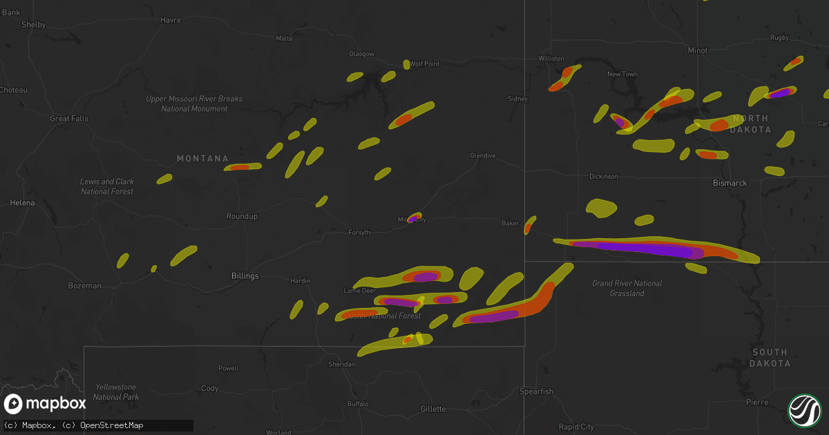
Hail Map on June 28, 2018
Get this storm
June 28 map
$229
one time, instant access
Download today. No call, no setup
Keep the $229
Bought the map and want the full workflow? Apply the entire $229 to a subscription within 7 days. None of it is wasted.
Every map, not just this one
This buys you this map. Subscription and you get every map we run, in the markets you choose from a few cities to whole states to nationwide. Plus real-time alerts the moment a storm fires.
Contact data
Name, contact info, occupancy, even credit band for addresses in the footprint. You go from where it hit to who to call.
Become the source they trust
Unlimited branding weather history reports on demand. You already have the documented answer ready for the property owner, and you are the one who showed up with it.
Property data and RoofTrace estimates
Pull up any address you have got, its value and the exact code rules for that jurisdiction, straight from One Click Code. Then RoofTrace estimates the squares, pitch, and roof value, priced the way you price.
States Impacted by Hail Map on June 28, 2018
Storm reports
Kentucky
| Date | Description |
|---|---|
| 06/28/201811:58 AM CDT | Wind estimated. Large tree limbs snapped. Report received via social media. |
| 06/28/201811:55 AM CDT | Trees down along portions of ky highway 94 northeast of town. |
| 06/28/201811:51 AM CDT | Tree fell across old newburg road and onto a car. Report received via em. |
| 06/28/201811:50 AM CDT | Em reports numerous trees down across the eastern half of the county. |
| 06/28/201811:50 AM CDT | Metal building blown down and pushed 100 yards along faxon road. Time estimated. |
| 06/28/201811:45 AM CDT | Numerous trees snapped or down. Some fell on outbuildings. Most of the damage occurred along faxon road. |
| 06/28/201811:15 AM CDT | Power lines down across the southern portion of graves county. Report received via social media. |
| 06/28/20186:44 AM CDT | At 1144 AM CDT, severe thunderstorms were located along a line extending from Land Between the Lakes to near Paris, moving southeast at 40 mph. HAZARD...60 mph wind gusts and quarter size hail. SOURCE...Radar indicated. IMPACT...Hail damage to vehicles is expected. Expect wind damage to roofs, siding, and trees. Locations impacted include... Waverly, Camden, Dover, Erin, New Johnsonville, McEwen, Tennessee Ridge, Hurricane Mills, Big Rock, Cumberland City, Houston County Airport, Land Between The Lakes and Indian Mound. |
| 06/28/20184:27 AM CDT | At 927 PM CDT, a severe thunderstorm was located near Palmersville, or 14 miles east of Martin, moving south at 60 mph. HAZARD...70 mph wind gusts and quarter size hail. SOURCE...Radar indicated. IMPACT...Hail damage to vehicles is expected. Expect considerable tree damage. Wind damage is also likely to mobile homes, roofs, and outbuildings. Locations impacted include... Martin, Union City, Paris, Fulton, Paris Landing State Park, Dresden, South Fulton, Kenton, Sharon, Cottage Grove, Latham, Palmersville, Puryear, Woodland Mills, Rives, Jones Mill, Old Springville, Como, Ralston and Shaffner. |
| 06/28/20184:22 AM CDT | At 922 PM CDT, a severe thunderstorm was located near Troy, or 8 miles west of Union City, moving south at 60 mph. HAZARD...60 mph wind gusts and quarter size hail. SOURCE...Radar indicated. IMPACT...Hail damage to vehicles is expected. Expect wind damage to roofs, siding, and trees. Locations impacted include... Dyersburg, Caruthersville, Portageville, Hayti, Steele, Reelfoot Lake State Park, Tiptonville, Newbern, Ridgely, Troy, Obion, Hayti Heights, Cooter, Wardell, Clayton, Deering, Bradleytown, Heloise, Unionville and Bolton. |
| 06/28/20183:41 AM CDT | At 840 PM CDT, a severe thunderstorm was located near Cadiz, moving southeast at 60 mph. HAZARD...60 mph wind gusts. SOURCE...Radar indicated. IMPACT...Expect damage to roofs, siding, and trees. Locations impacted include... Dover, Clarksville, Big Rock, Cumberland City, Land Between The Lakes, Indian Mound, Palmyra and Woodlawn. |
| 06/28/20183:36 AM CDT | At 836 PM CDT, severe thunderstorms were located along a line extending from Energy to 7 miles north of Towosahgy State Historic Site, moving northeast at 30 mph. HAZARD...60 mph wind gusts. SOURCE...Radar indicated. IMPACT...Expect damage to roofs, siding, and trees. Locations impacted include... Martin, Union City, Paris, Caruthersville, McKenzie, Fulton, Paris Landing State Park, Reelfoot Lake State Park, Tiptonville, Newbern, Dresden, South Fulton, Dyer, Greenfield, Ridgely, Gleason, Troy, Kenton, Rutherford and Obion. |
| 06/28/20182:55 AM CDT | At 755 PM CDT, severe thunderstorms were located along a line extending from near Tamms to near Daisy, moving south at 35 mph. HAZARD...60 mph wind gusts and penny size hail. SOURCE...Radar indicated. IMPACT...Expect damage to roofs, siding, and trees. Locations impacted include... Cape Girardeau, Scott City, Chaffee, Cairo, Oran, Benton, Tamms, Kelso, Delta, Dutchtown, Olive Branch, Horseshoe Lake Conservation Area, Grassy, Thebes, Allenville, Commerce, Lambert and East Cape Girardeau. |
| 06/27/20189:59 PM CDT | At 259 PM CDT, a severe thunderstorm was located over Farmersville, or 8 miles north of Princeton, moving southeast at 10 mph. HAZARD...60 mph wind gusts and quarter size hail. SOURCE...Radar indicated. IMPACT...Hail damage to vehicles is expected. Expect wind damage to roofs, siding, and trees. Locations impacted include... Princeton, Farmersville and Fryer. |
| 06/27/20189:14 PM CDT | Power outage reported for the entire hazel area. |
| 06/27/20189:10 PM CDT | Near sinking fork school on highway 91 northwest of hopkinsville |
| 06/27/20189:02 PM CDT | Estimated 700-800 customers without power in the fredonia area. |
| 06/27/20189:00 PM CDT | 65 mph winds estimated and power is out on hwy 91 at sinking fork church |
| 06/27/20188:52 PM CDT | Widespread power outages reported in ballard county. |
| 06/27/20188:52 PM CDT | Power outage reported for the entire hazel area. |
| 06/27/20188:52 PM CDT | Widespread power outages reported in trigg county. |
| 06/27/20188:50 PM CDT | Several reports of large tree limbs and trees down along with power outages |
| 06/27/20188:49 PM CDT | Multiple trees down on the north side of cadiz. |
| 06/27/20188:45 PM CDT | Large maple tree down onto power line on peggy ann drive on south side of murray. |
| 06/27/20188:45 PM CDT | Hwy 62 between cunningham and bardwell basically impassable due to so many trees across the road. Widespread tree damage across the county. |
| 06/27/20188:44 PM CDT | Tree down on a house. |
| 06/27/20188:40 PM CDT | Tree on house in cunningham area on county road 1054. Multiple trees down throughout the county. |
| 06/27/20188:40 PM CDT | Estimated 60 mph winds in farmington |
| 06/27/20188:30 PM CDT | 80 percent of town without power. |
| 06/27/20188:21 PM CDT | Power outages reported in lone oak. |
| 06/27/20188:20 PM CDT | Estimated 60 mph winds. |
| 06/27/20188:20 PM CDT | 8-10 inch diameter tree down and 6 foot fence panel down. |
| 06/27/20188:15 PM CDT | Large tree took down power poles and lines in front of a house. |
| 06/27/20188:15 PM CDT | Numerous trees down across the county. |
| 06/27/20188:14 PM CDT | Tree down on a house. |
| 06/27/20188:12 PM CDT | Estimated 700-800 customers without power in the fredonia area. |
| 06/27/20188:10 PM CDT | Several reports of trees and large limbs down |
| 06/27/20188:10 PM CDT | Numerous reports of trees and power lines down and some power outages in the paducah area. |
| 06/27/20188:09 PM CDT | Measured wind gust to 62 mph at kpah asos. |
| 06/27/20188:04 PM CDT | Widespread power outages reported in ballard county. |
| 06/27/20188:00 PM CDT | Several trees uprooted on hwy 60 near intersection of hwy 135 |
| 06/27/20187:15 PM CDT | Several trees uprooted on hwy 60 near intersection of hwy 135 |
Missouri
| Date | Description |
|---|---|
| 06/28/20186:50 PM CDT | *** 1 inj *** a person was hit by awning at intersection of hwy 51 and 61 due to strong winds. |
| 06/28/20185:57 PM CDT | Report via social media of tree down. Time estimated from radar. |
| 06/28/20185:56 PM CDT | Large healthy trees toppled. |
| 06/28/20185:54 PM CDT | Media report via social media. Trees and power lines down. Time estimated from radar. |
| 06/28/20185:42 PM CDT | Light pole snapped near base. Time estimated from radar. Twitter report. |
| 06/28/20185:41 PM CDT | Large tree uprooted blocking fountain avenue. |
| 06/28/20185:41 PM CDT | Delayed report: large tree down near the round about heading into forrest park near the zoo off 64/40. |
| 06/28/20185:41 PM CDT | Report via social media of large tree limb down. |
| 06/28/20185:38 PM CDT | Report via social media of tree down. |
| 06/28/20185:38 PM CDT | Large tree branches on power lines and blocking riverview drive near chambers road. |
| 06/28/20185:36 PM CDT | Corrects previous tstm wnd dmg report from 2 wnw spanish lake. Bus stop bench blown into the street and many limbs down. |
| 06/28/20185:33 PM CDT | Corrects previous tstm wnd dmg report from spanish lake. Report via social media of tree down. Also a shed torn off. Time estimated from radar. |
| 06/28/20185:33 PM CDT | Large tree fell onto house breaking through half of the house and destroying the entire room. |
| 06/28/20185:33 PM CDT | Corrects previous tstm wnd dmg report from spanish lake. Report via social media of tree down. Also a shed torn off. Time estimated from radar. |
| 06/28/20185:31 PM CDT | Delayed report: several trees down in areas along 94 and dwiggins. One largest tree was blocking 94. |
| 06/28/20185:28 PM CDT | High voltage power lines down; pole to pole. Time estimated by radar. |
| 06/28/20185:28 PM CDT | Measured by oregon scientific instrument at hwy 270 and lindenberg blvd. |
| 06/28/20185:28 PM CDT | Several large branches down across the area. |
| 06/28/20185:23 PM CDT | Damage to docks... A capsized boat... And wires down at liberty docks. |
| 06/28/20185:23 PM CDT | Two large trees snapped at base. Time estimated by radar. |
| 06/28/20185:18 PM CDT | Wooden barn flattened. |
| 06/28/20185:17 PM CDT | Wires down on veterans memorial and elm street near lindenwood university. Twitter report. |
| 06/28/20185:17 PM CDT | A local report indicates 59 MPH wind near 3 NNE ORCHARD FARMS |
| 06/28/20185:15 PM CDT | Delayed report: photo submitted on social media of a large silver maple tree down by wind near harvester and 94. Time estimated by radar. |
| 06/28/20184:40 PM CDT | Multiple reports of trees knocked down. |
| 06/28/20184:38 PM CDT | Large tree blocking riverview dr. Time estimated by radar. |
| 06/28/20184:22 PM CDT | A tree was downed and a stop sign was knocked over. |
| 06/28/20184:20 PM CDT | Power line down. |
| 06/28/20183:45 PM CDT | Tree across road. |
| 06/28/20182:15 PM CDT | Time estimated. 12 inch diameter tree downed by thunderstorm winds. |
| 06/28/20182:05 PM CDT | Winds occurred around 205 pm. |
| 06/28/20182:05 PM CDT | A local report indicates 60 MPH wind near KIRKSVILLE |
| 06/28/20181:55 PM CDT | *** 1 inj *** delayed report and time estimated from radar. Woman hospitalized from falling tree. Reported by wgem. |
| 06/28/20181:03 PM CDT | Quarter to ping pong ball size hail. |
| 06/28/201810:26 AM CDT | Several thousand customers without power in southern cape girardeau county and northern scott county. |
| 06/28/201810:15 AM CDT | Power lines down... Power outages reported. Report received via social media. |
| 06/28/201810:02 AM CDT | Wind gusts estimated 60 to 65 mph. |
| 06/28/201810:00 AM CDT | Numerous trees and power lines down. Report received via social media. |
| 06/28/20189:45 AM CDT | Large tree limbs down. Received via social media. |
| 06/28/20189:40 AM CDT | Tree down and hail... Size of hail unknown |
| 06/28/20187:57 AM CDT | At 1256 PM CDT, severe thunderstorms were located along a line extending from near Corydon to near Mercer, moving east at 40 mph. HAZARD...60 mph wind gusts and penny size hail. SOURCE...Radar indicated. IMPACT...Expect damage to roofs, siding, and trees. Locations impacted include... Centerville, Corydon, Seymour, Allerton, Humeston, Cincinnati, Lineville, Exline, Promise City, Numa, Clio, Plano, Pleasanton and Centerville Municipal Airport. |
| 06/28/20187:04 AM CDT | At 1202 PM CDT, severe thunderstorms were located along a line extending from 8 miles north of Lakeside Casino to 8 miles southwest of Osceola to 7 miles east of Mount Ayr, moving southeast at 55 mph. HAZARD...70 mph wind gusts and nickel size hail. SOURCE...Trained weather spotters. These storms have produced widespread 60 to 70 mph wind gusts with widespread wind damage. IMPACT...Expect considerable tree damage. Damage is likely to mobile homes, roofs, and outbuildings. Locations impacted include... Osceola, Chariton, Leon, Mount Ayr, Corydon, Lamoni, Sun Valley Lake, Lakeside Casino, Rathbun Lake, Murray, Seymour, Russell, Allerton, Humeston, New Virginia, Kellerton, Grand River, Van Wert, Lineville and Lucas.This includes Interstate 35 between mile markers 1 and 51. |
| 06/28/20186:24 AM CDT | At 1124 PM CDT, a severe thunderstorm was located near Bay, moving southwest at 55 mph. HAZARD...60 mph wind gusts. SOURCE...Radar indicated. IMPACT...Expect damage to roofs, siding, and trees. Locations impacted include... Jonesboro, Paragould, Trumann, Pocahontas, Walnut Ridge, Hoxie, Marked Tree, Harrisburg, Bono, Lake City, Lepanto, Bay, Brookland, Monette, Caraway, Tyronza, Black Rock, Lake Charles State Park, Crowleys Ridge State Park and Lake Frierson State Park. |
| 06/28/20185:54 AM CDT | At 1054 PM CDT, a severe thunderstorm was located over Lafe, or near Marmaduke, moving southwest at 50 mph. HAZARD...60 mph wind gusts and quarter size hail. SOURCE...Radar indicated. IMPACT...Hail damage to vehicles is expected. Expect wind damage to roofs, siding, and trees. Locations impacted include... Paragould, Pocahontas, Walnut Ridge, Corning, Hoxie, Marmaduke, Black Rock, Crowleys Ridge State Park, Lake Frierson State Park, Oak Grove Heights, Cardwell, Imboden, Arbyrd, Ravenden, Lafe, Reyno, College City, Portia, Maynard and Biggers. |
| 06/28/20184:57 AM CDT | At 957 AM CDT, a severe thunderstorm was located near Delta, or 8 miles northwest of Chaffee, moving southeast at 40 mph. HAZARD...70 mph wind gusts and quarter size hail. SOURCE...Radar indicated. IMPACT...Hail damage to vehicles is expected. Expect considerable tree damage. Wind damage is also likely to mobile homes, roofs, and outbuildings. Locations impacted include... Cape Girardeau, Sikeston, Scott City, Chaffee, Advance, Oran, Miner, Benton, Morley, Kelso, Bell City, Delta, Dutchtown, Hay-Wood City, Horseshoe Lake Conservation Area, Olive Branch, Thebes, Vanduser, Blodgett and Baker. |
| 06/28/20183:59 AM CDT | At 858 AM CDT, a severe thunderstorm was located over Fredericktown, moving southeast at 35 mph. HAZARD...Quarter size hail. SOURCE...Radar indicated. IMPACT...Damage to vehicles is expected. Locations impacted include... Fredericktown, Junction City, Cobalt, Marquand, Buckhorn, Mine La Motte and Catherine Place. |
| 06/28/20183:53 AM CDT | At 853 AM CDT, a severe thunderstorm was located over Perry, moving southeast at 25 mph. HAZARD...Quarter size hail. SOURCE...Radar indicated. IMPACT...Damage to vehicles is expected. Locations impacted include... Vandalia, Perry, Laddonia, Center, Farber, Curryville and Spencerburg. |
| 06/28/20183:14 AM CDT | At 814 PM CDT, severe thunderstorms were located along a line extending from near Eddyville to 6 miles south of Lone Oak to near Mound City, moving southeast at 70 mph. HAZARD...60 mph wind gusts. SOURCE...Radar indicated. IMPACT...Expect damage to roofs, siding, and trees. Locations impacted include... Paducah, Cairo, La Center, Wickliffe, Reidland, Lone Oak, Brookport, Mounds, Barlow, Mound City, Ledbetter, West Paducah, Lovelaceville, Ullin, Kevil, Olmsted, Smithland, Pulaski, Hamletsburg and Blandville. |
| 06/28/20183:03 AM CDT | At 803 AM CDT, a severe thunderstorm was located over Cedar Hill Lakes, moving southeast at 25 mph. HAZARD...Quarter size hail. SOURCE...Radar indicated. IMPACT...Damage to vehicles is expected. Locations impacted include... Festus, De Soto, Pevely, Crystal City, Herculaneum, Hillsboro, Byrnes Mill, Cedar Hill, Olympian Village, Cedar Hill Lakes, Dittmer, Horine, Scotsdale, Hematite, Victoria, Morse Mill, Oermann, Mapaville, Valles Mill and Grubville.This includes Interstate 55 in Missouri between exits 170 and 178. This also includes Sandy Creek Covered Bridge Historic Site. |
| 06/28/20182:58 AM CDT | At 758 AM CDT, a severe thunderstorm was located near Monroe City, moving southeast at 25 mph. HAZARD...Quarter size hail. SOURCE...Radar indicated. IMPACT...Damage to vehicles is expected. Locations impacted include... Center, Spaulding and The Landing. |
| 06/28/20182:35 AM CDT | At 734 PM CDT, severe thunderstorms were located along a line extending from near Equality to 10 miles north of Dixon Springs to near Goreville to near Cobden, moving southeast at 70 mph. HAZARD...70 mph wind gusts and quarter size hail. SOURCE...Trained weather spotters. IMPACT...Hail damage to vehicles is expected. Expect considerable tree damage. Wind damage is also likely to mobile homes, roofs, and outbuildings. Locations impacted include... Paducah, Metropolis, La Center, Wickliffe, Reidland, Lone Oak, Marion, Rosiclare, Brookport, Mounds, Salem, Barlow, Golconda, Mound City, Karnak, Burna, Ledbetter, Lovelaceville, New Columbia and Dixon Springs. |
| 06/28/20182:34 AM CDT | At 734 AM CDT, a severe thunderstorm was located near Perry, moving southeast at 20 mph. HAZARD...Quarter size hail. SOURCE...Radar indicated. IMPACT...Damage to vehicles is expected. Locations impacted include... Vandalia, Perry and Florida. This also includes Mark Twain Lake Recreational Area. |
| 06/28/20182:00 AM CDT | At 659 PM CDT, severe thunderstorms were located along a line extending from near Bluford to near Christopher to Percy, moving southeast at 50 mph. HAZARD...70 mph wind gusts and half dollar size hail. SOURCE...Radar indicated. IMPACT...Hail damage to vehicles is expected. Expect considerable tree damage. Wind damage is also likely to mobile homes, roofs, and outbuildings. Locations impacted include... Carbondale, Marion, Herrin, Harrisburg, Murphysboro, Carterville, Anna, Eldorado, Johnston City, Jonesboro, Vienna, Crainville, Cambria, Cobden, Energy, Goreville, Galatia, Ridgway, Hurst and Dongola. |
| 06/28/20181:10 AM CDT | At 610 AM CDT, a severe thunderstorm was located over Browning, or 9 miles south of Milan, moving southeast at 25 mph. HAZARD...60 mph wind gusts and quarter size hail. SOURCE...Radar indicated. IMPACT...Hail damage to vehicles is expected. Expect wind damage to roofs, siding, and trees. Locations impacted include... Linneus, Browning and Purdin. |
| 06/28/201812:58 AM CDT | At 557 AM CDT, a severe thunderstorm was located over Murry, moving south at 15 mph. HAZARD...Ping pong ball size hail and 60 mph wind gusts. SOURCE...Radar indicated. IMPACT...People and animals outdoors will be injured. Expect hail damage to roofs, siding, windows, and vehicles. Expect wind damage to roofs, siding, and trees. Locations impacted include... Columbia, Fulton, Columbia Regional Airport, Hallsville, Murry and Carrington.This includes Interstate 70 in Missouri between exits 131 and 144. |
| 06/28/201812:38 AM CDT | At 537 AM CDT, a severe thunderstorm was located 8 miles west of Milan, moving south at 25 mph. HAZARD...60 mph wind gusts and half dollar size hail. SOURCE...Radar indicated. IMPACT...Hail damage to vehicles is expected. Expect wind damage to roofs, siding, and trees. Locations impacted include... Milan, Browning, Galt, Humphreys, Osgood and Reger. |
| 06/28/201812:22 AM CDT | At 521 PM CDT, severe thunderstorms were located along a line extending from near Taylorville to Witt to near Carlinville to near Orchard Farms, moving southeast at 60 mph. HAZARD...60 mph wind gusts. SOURCE...Trained weather spotters. Numerous trees and power lines have been reported down when this line of storms moved through parts of Missouri and Illinois. IMPACT...Expect damage to roofs, siding, and trees. Locations impacted include... St. Louis, Chesterfield, Belleville, University City, Ballwin, Granite City, O'Fallon, Kirkwood, Maryland Heights, East St. Louis, Collinsville, Edwardsville, Webster Groves, Ferguson, Arnold, Manchester, Creve Coeur, Fairview Heights, Overland and Clayton.This includes the following highways... Interstate 70 in Illinois between exits 21 and 76. Interstate 55 in Illinois between exits 23 and 44. Interstate 57 in Illinois between exits 116 and 135. Interstate 64 in Illinois between exits 9 and 41. Interstate 44 in Missouri between exits 272 and 277. Interstate 55 in Missouri between exits 187 and 191.This also includes Scott Joplin Historic Site, Mastodon HistoricSite, Ramsey Lake State Park, Carlyle Lake Recreational Area, andHorseshoe Lake State Park. |
| 06/28/201812:18 AM CDT | At 517 AM CDT, a severe thunderstorm was located near Sturgeon, moving southeast at 25 mph. HAZARD...60 mph wind gusts and half dollar size hail. SOURCE...Radar indicated. IMPACT...Hail damage to vehicles is expected. Expect wind damage to roofs, siding, and trees. Locations impacted include... Centralia, Hallsville, Auxvasse, Sturgeon, Murry, Kingdom City and Hatton.This includes Interstate 70 in Missouri between exits 137 and 148. |
| 06/28/201812:13 AM CDT | At 513 AM CDT, a severe thunderstorm was located 10 miles southwest of Marceline, moving southeast at 30 mph. HAZARD...60 mph wind gusts and quarter size hail. SOURCE...Radar indicated. IMPACT...Hail damage to vehicles is expected. Expect wind damage to roofs, siding, and trees. Locations impacted include... Marceline, Brunswick, Keytesville, Mendon, Sumner, Rothville, Triplett, Dalton and Prairie Hill. |
| 06/28/201812:12 AM CDT | At 511 AM CDT, a severe thunderstorm was located over Sturgeon, moving southeast at 25 mph. HAZARD...60 mph wind gusts and quarter size hail. SOURCE...Radar indicated. IMPACT...Hail damage to vehicles is expected. Expect wind damage to roofs, siding, and trees. Locations impacted include... Centralia, Hallsville and Sturgeon. |
| 06/28/201812:05 AM CDT | At 505 AM CDT, a severe thunderstorm was located 8 miles east of Princeton, or 21 miles northwest of Milan, moving southeast at 20 mph. HAZARD...60 mph wind gusts and half dollar size hail. SOURCE...Radar indicated. IMPACT...Hail damage to vehicles is expected. Expect wind damage to roofs, siding, and trees. Locations impacted include... Princeton, Newtown, Lucerne, Harris and Osgood. |
| 06/27/201811:51 PM CDT | At 451 AM CDT, a severe thunderstorm was located near Martinsburg, moving east at 25 mph. HAZARD...Quarter size hail. SOURCE...Radar indicated. IMPACT...Damage to vehicles is expected. Locations impacted include... Laddonia, Martinsburg, New Hartford, Middletown and Rush Hill. |
| 06/27/201811:42 PM CDT | At 442 AM CDT, a severe thunderstorm was located near Laclede, or 7 miles west of Brookfield, moving southeast at 30 mph. HAZARD...60 mph wind gusts and half dollar size hail. SOURCE...Radar indicated. IMPACT...Hail damage to vehicles is expected. Expect wind damage to roofs, siding, and trees. Locations impacted include... Brookfield, Marceline, Meadville, Laclede, Mendon, Sumner, Rothville, Triplett and Saint Catherine. |
| 06/27/201811:34 PM CDT | At 433 AM CDT, a severe thunderstorm was located over Hallsville, moving southeast at 10 mph. HAZARD...Quarter size hail. SOURCE...Radar indicated. IMPACT...Damage to vehicles is expected. Locations impacted include... Columbia, Hallsville and Murry. This includes Interstate 70 in Missouri between exits 131 and 133. This also includes Finger Lakes State Park. |
| 06/27/201811:21 PM CDT | At 421 AM CDT, a severe thunderstorm was located near Linneus, or 13 miles northwest of Brookfield, moving southeast at 25 mph. HAZARD...60 mph wind gusts and quarter size hail. SOURCE...Radar indicated. IMPACT...Hail damage to vehicles is expected. Expect wind damage to roofs, siding, and trees. Locations impacted include... Brookfield, Meadville, Laclede, Linneus and Purdin. |
| 06/27/201810:53 PM CDT | At 353 AM CDT, a severe thunderstorm was located near Galt, or 10 miles east of Trenton, moving southeast at 25 mph. HAZARD...60 mph wind gusts and quarter size hail. SOURCE...Radar indicated. IMPACT...Hail damage to vehicles is expected. Expect wind damage to roofs, siding, and trees. Locations impacted include... Browning, Galt, Laredo and Humphreys. |
| 06/27/201810:02 PM CDT | Trees down. |
| 06/27/20189:43 PM CDT | Trees down. |
| 06/27/20189:29 PM CDT | At 227 PM CDT, severe thunderstorms were located along a line extending from near Lowell to near Wayland to near Colony, moving southeast at 50 mph. HAZARD...60 mph wind gusts and penny size hail. SOURCE...Radar indicated. IMPACT...Expect damage to roofs, siding, and trees. Locations impacted include... Burlington, Fort Madison, Keokuk, Carthage, Nauvoo, West Burlington, Hamilton, Warsaw, La Harpe, Dallas City, Danville, Montrose, Stronghurst, Bowen, Middletown, Carman, Terre Haute, West Point, Ferris and Gulf Port. |
| 06/27/20189:05 PM CDT | At 205 PM CDT, a severe thunderstorm was located near La Plata, moving southeast at 30 mph. HAZARD...60 mph wind gusts and quarter size hail. SOURCE...Radar indicated. IMPACT...Hail damage to vehicles is expected. Expect wind damage to roofs, siding, and trees. Locations impacted include... La Plata, Millard and Kirksville Regional. |
| 06/27/20189:00 PM CDT | At 200 PM CDT, severe thunderstorms were located along a line extending from near Cantril to near Greentop, moving southeast at 70 mph. HAZARD...60 mph wind gusts and quarter size hail. SOURCE...Radar indicated. IMPACT...Hail damage to vehicles is expected. Expect wind damage to roofs, siding, and trees. Locations impacted include... Edina, La Belle, Lewistown, Ewing, Knox City, Greensburg, Plevna, Steffenville, Colony, Hurdland, Novelty, Baring, Bethel, Monticello, Newark and Leonard. |
| 06/27/20188:54 PM CDT | At 153 PM CDT, severe thunderstorms were located along a line extending from near Delta to Birmingham to 6 miles southwest of Memphis, moving east at 55 mph. HAZARD...70 mph wind gusts and quarter size hail. SOURCE...Radar indicated. IMPACT...Hail damage to vehicles is expected. Expect considerable tree damage. Wind damage is also likely to mobile homes, roofs, and outbuildings. Locations impacted include... Fort Madison, Fairfield, Mount Pleasant, Kahoka, New London, Winfield, West Point, Donnellson, Brighton, Wayland, Birmingham, Bonaparte, Salem, Stockport, Lockridge, Olds, Wyaconda, Hillsboro, Franklin and St. Paul. |
| 06/27/20188:20 PM CDT | Large tree down near teen challenge in jackson |
| 06/27/20188:12 PM CDT | At 111 PM CDT, severe thunderstorms were located along a line extending from near Pella to 7 miles east of Unionville, moving east at 50 mph. HAZARD...70 mph wind gusts and nickel size hail. SOURCE...Radar indicated. IMPACT...Expect considerable tree damage. Damage is likely to mobile homes, roofs, and outbuildings. Locations impacted include... Fairfield, Sigourney, Memphis, Keosauqua, Hedrick, What Cheer, Richland, Batavia, Birmingham, Milton, Delta, Libertyville, Maharishi Vedic City, Keswick, Cantril, South English, Packwood, Harper, Martinsburg and Rutledge. |
| 06/27/20188:06 PM CDT | At 106 PM CDT, severe thunderstorms were located along a line extending from near Pella to near Albia to near Centerville, moving east at 50 mph. These are very dangerous storms. HAZARD...80 mph wind gusts and penny size hail. SOURCE...Trained weather spotters. These storms have a history of widespread wind damage. IMPACT...Flying debris will be dangerous to those caught without shelter. Mobile homes will be heavily damaged. Expect considerable damage to roofs, windows, and vehicles. Extensive tree damage and power outages are likely. Locations impacted include... Ottumwa, Oskaloosa, Bloomfield, Eddyville, Ottumwa Industrial Airport, Eldon, Fremont, Agency, University Park, Blakesburg, Pulaski, Drakesville, Barnes City, Rose Hill, Kirkville, Floris, Chillicothe, Keomah Village, Oskaloosa Municipal Airport and Lake Wapello State Park. |
| 06/27/20188:01 PM CDT | Public photo on social media: large limb or part of a large tree was blown down. Limb caused minor damage to the gutter of the house. |
| 06/27/20188:00 PM CDT | Trees and power lines down across highway n. |
| 06/27/20187:53 PM CDT | Large tree down near teen challenge in jackson |
| 06/27/20187:50 PM CDT | *** 1 inj *** a person was hit by awning at intersection of hwy 51 and 61 due to strong winds. |
| 06/27/20187:40 PM CDT | Delayed report: public photo shared via social media. Time is estimated by radar. |
| 06/27/20187:40 PM CDT | Correction from earlier report: delayed report: public photo shared via social media. Time is estimated by radar. |
| 06/27/20187:22 PM CDT | Large tree down by railroad crossing. |
Colorado
| Date | Description |
|---|---|
| 06/28/20186:40 PM CDT | Asos station laa... Lamar airport. |
| 06/28/20185:32 PM CDT | Corrects previous non-tstm wnd gst report from 1 w las animas. |
| 06/28/201812:58 AM CDT | At 557 PM MDT, a severe thunderstorm was located over Lamar, moving northeast at 20 mph. The ASOS in Lamar reported a 73 mph gust. HAZARD...70 mph wind gusts. SOURCE...Trained weather spotters. IMPACT...Expect considerable tree damage. Damage is likely to mobile homes, roofs, and outbuildings. Locations impacted include... Lamar, Granada and Wiley. |
| 06/27/201811:52 PM CDT | At 452 PM MDT, a severe thunderstorm was located 10 miles south of John Martin Reservoir, or 24 miles southwest of Lamar, moving northeast at 20 mph. HAZARD...60 mph wind gusts and penny size hail. SOURCE...Radar indicated. IMPACT...Expect damage to roofs, siding, and trees. Locations impacted include... Hasty, John Martin Reservoir and Caddoa. |
| 06/27/201811:16 PM CDT | At 416 PM MDT, a severe thunderstorm was located 9 miles south of Las Animas, or 15 miles east of North La Junta, moving northeast at 15 mph. A landspout tornado is possible. HAZARD...60 mph wind gusts and quarter size hail. SOURCE...Radar indicated. IMPACT...Hail damage to vehicles is expected. Expect wind damage to roofs, siding, and trees. Locations impacted include... Las Animas, John Martin Reservoir and Fort Lyon. |
| 06/27/20189:53 PM CDT | At 252 PM MDT, a severe thunderstorm was located 11 miles east of Cope, or 21 miles north of Stratton, moving northeast at 15 mph. HAZARD...70 mph wind gusts. SOURCE...Radar indicated. IMPACT...Expect considerable tree damage. Damage is likely to mobile homes, roofs, and outbuildings. Locations impacted include... Joes and Kirk. |
North Dakota
| Date | Description |
|---|---|
| 06/28/20184:32 PM CDT | A local report indicates 1.00 inch wind near 7.1NNW WATFORD CITY |
| 06/28/20183:43 PM CDT | Large hail spread across highway 2 just west of turtle river state park. Time estimated based on radar. |
| 06/28/20183:35 PM CDT | Social media post showing hail slightly larger than quarter sized. |
| 06/28/20183:34 PM CDT | Reported along highway 2... About 3 miles west of nd18 intersection. |
| 06/28/20183:34 PM CDT | Reported along highway 2. |
| 06/28/201812:49 PM CDT | Heavy rain causing some street flooding near 8th ave. North and 43rd. Water up to the the curb. |
| 06/28/201812:45 PM CDT | Photo of one inch hail relayed via social media. Time is radar estimated. |
| 06/28/20189:10 AM CDT | Quarter sized hail lasted 5 minutes in duration. |
| 06/28/20188:07 AM CDT | Deputy in adams county reported damage to vehicles... With many windows broken out due to large hail up to 2.5 inches in diameter. |
| 06/28/20187:58 AM CDT | A local report indicates 3.00 inch wind near 7 N HETTINGER |
| 06/28/20187:54 AM CDT | Adams county em relayed a public report of baseball size hail... With extensive damage to homes |
| 06/28/20187:12 AM CDT | Hail ongoing at time of report. Relayed by media. |
| 06/28/20187:08 AM CDT | Report relayed by broadcast media. |
| 06/28/20186:38 AM CDT | At 1138 PM CDT/1038 PM MDT/, severe thunderstorms were located along a line extending from 4 miles east of Garrison to 8 miles southeast of Indian Hills Recreation Area to 8 miles north of Richardton, moving east at 40 mph. These are very dangerous storms. HAZARD...80 mph wind gusts and half dollar size hail. SOURCE...Radar indicated. IMPACT...Flying debris will be dangerous to those caught without shelter. Mobile homes will be heavily damaged. Expect considerable damage to roofs, windows, and vehicles. Extensive tree damage and power outages are likely. Severe thunderstorms will be near... Beulah Bay Recreation Area around 1155 PM CDT. Hazen Bay Recreation Area around 1200 AM CDT. Pick City, Lake Sakakawea State Park and Fort Stevenson State Park around 1215 AM CDT. Riverdale around 1220 AM CDT. Coleharbor around 1230 AM CDT. Underwood around 1235 AM CDT. Turtle Lake around 1245 AM CDT.Other locations impacted by these severe thunderstorms include WhiteShield, Strawberry Lake, Price, Twin Buttes, Falkirk, Sanger, Ruso,Hensler, Dakota Waters Recreation Area and Emmet. |
| 06/28/20186:20 AM CDT | Tree... Plenty of branches down at emergency manager residence. Damage resulted from high wind subsequent to the earlier bow echo... Which did not cause any damage in t |
| 06/28/20186:19 AM CDT | At 1119 PM CDT, severe thunderstorms were located along a line extending from 6 miles northeast of Maxbass to near Donnybrook to 6 miles southwest of Makoti, moving east at 55 mph. HAZARD...70 mph wind gusts and quarter size hail. SOURCE...Radar indicated. IMPACT...Hail damage to vehicles is expected. Expect considerable tree damage. Wind damage is also likely to mobile homes, roofs, and outbuildings. Severe thunderstorms will be near... Westhope and Newburg around 1125 PM CDT. Foxholm and Rice Lake around 1135 PM CDT. Douglas and Souris around 1140 PM CDT. Minot Air Force Base around 1145 PM CDT. Bottineau around 1150 PM CDT. Glenburn around 1155 PM CDT. Deering around 1200 AM CDT. Upham around 1215 AM CDT.Other locations impacted by these severe thunderstorms includeBergen, Norwich, Bantry, Voltaire, Hartland, Landa, Tolley, Grano,George Lake and Eckman. |
| 06/28/20186:00 AM CDT | Trampoline re arranged within backyard. Event time is time of report... Damage would have occurred earlier. Reported via social media. |
| 06/28/20185:46 AM CDT | At 1046 PM CDT/946 PM MDT/, severe thunderstorms were located along a line extending from 6 miles south of Van Hook Park to 4 miles northwest of Halliday to 10 miles northwest of Dickinson, moving east at 50 mph. HAZARD...70 mph wind gusts and quarter size hail. SOURCE...Radar indicated. IMPACT...Hail damage to vehicles is expected. Expect considerable tree damage. Wind damage is also likely to mobile homes, roofs, and outbuildings. Severe thunderstorms will be near... Halliday around 950 PM MDT. Dodge around 1000 PM MDT. Golden Valley around 1005 PM MDT. Zap around 1115 PM CDT. Roseglen around 1120 PM CDT. Beulah and Beulah Bay Recreation Area around 1125 PM CDT. Hazen and Hazen Bay Recreation Area around 1130 PM CDT.Other locations impacted by these severe thunderstorms include SkunkCreek Bay Recreation Area, White Shield, Twin Buttes, Pouch PointRecreation Area, Hirschville, Deep Water Creek Recreation Area,Dakota Waters Recreation Area, Oakdale, Raub and Emmet. |
| 06/28/20185:41 AM CDT | At 1040 PM CDT, severe thunderstorms were located along a line extending from near Battleview to 6 miles southwest of Ross to 7 miles south of 4 Bears Lodge, moving east at 45 mph. These are very dangerous storms. HAZARD...80 mph wind gusts and quarter size hail. SOURCE...Trained weather spotters. IMPACT...Flying debris will be dangerous to those caught without shelter. Mobile homes will be heavily damaged. Expect considerable damage to roofs, windows, and vehicles. Extensive tree damage and power outages are likely. Severe thunderstorms will be near... Ross around 1045 PM CDT. New Town around 1050 PM CDT. Stanley and Belden around 1055 PM CDT. Van Hook Park around 1100 PM CDT. Palermo around 1110 PM CDT. Parshall around 1115 PM CDT. Blaisdell around 1120 PM CDT. Kenmare and Plaza around 1130 PM CDT.Other locations impacted by these severe thunderstorms include WhiteEarth, Keene, Coulee, White Earth Bay Recreation Area, Tagus, Coteau,Hartland, Mcgregor, Charlson and Niobe. |
| 06/28/20185:30 AM CDT | At 1029 PM MDT, severe thunderstorms were located along a line extending from 7 miles north of Dickinson to 10 miles west of New England, moving east at 55 mph. HAZARD...70 mph wind gusts and quarter size hail. SOURCE...Radar indicated. IMPACT...Hail damage to vehicles is expected. Expect considerable tree damage. Wind damage is also likely to mobile homes, roofs, and outbuildings. These severe thunderstorms will remain over mainly rural areas of Stark County, including the following locations... Schefield, Lefor and Dickinson Regional Airport. |
| 06/28/20185:26 AM CDT | At 1025 PM MDT, severe thunderstorms were located along a line extending from 11 miles northeast of Marmarth to near Rhame to near Mud Buttes, moving northeast at 60 mph. HAZARD...70 mph wind gusts and quarter size hail. SOURCE...Radar indicated. IMPACT...Hail damage to vehicles is expected. Expect considerable tree damage. Wind damage is also likely to mobile homes, roofs, and outbuildings. Severe thunderstorms will be near... Bowman and Amidon around 1045 PM MDT. Scranton around 1055 PM MDT. New England around 1115 PM MDT.Other locations impacted by these severe thunderstorms include SunsetButte, Bowman Haley Dam, Bucyrus, Griffin, Buffalo Springs, Havelockand Gascoyne. |
| 06/28/20185:13 AM CDT | At 1012 PM MDT, severe thunderstorms were located along a line extending from 22 miles northwest of Table Mountain to 15 miles west of Ladner to 19 miles west of Camp Crook, moving east at 40 mph. HAZARD...70 mph wind gusts and quarter size hail. SOURCE...Radar indicated. IMPACT...Hail damage to vehicles is expected. Expect considerable tree damage. Wind damage is also likely to mobile homes, roofs, and outbuildings. Locations impacted include... Ludlow, Camp Crook, Ladner, Table Mountain, South Cave Hills, North Cave Hills and Lake Gardner. |
| 06/28/20185:07 AM CDT | At 1006 PM CDT/906 PM MDT/, a severe thunderstorm was located 5 miles south of Indian Hills Recreation Area, or 25 miles northwest of Beulah, moving northeast at 25 mph. HAZARD...Ping pong ball size hail and 60 mph wind gusts. SOURCE...Radar indicated. IMPACT...People and animals outdoors will be injured. Expect hail damage to roofs, siding, windows, and vehicles. Expect wind damage to roofs, siding, and trees. This severe thunderstorm will be near... Indian Hills Recreation Area around 1020 PM CDT. Roseglen around 1055 PM CDT.Other locations impacted by this severe thunderstorm include WhiteShield, Twin Buttes and Raub. |
| 06/28/20184:58 AM CDT | At 957 AM CDT, a severe thunderstorm was located over Selfridge, moving east at 40 mph. HAZARD...Ping pong ball size hail. SOURCE...Radar indicated. IMPACT...People and animals outdoors will be injured. Expect damage to roofs, siding, windows, and vehicles. This severe thunderstorm will be near... Fort Yates around 1020 AM CDT. Strasburg and Westfield around 1050 AM CDT.Other locations impacted by this severe thunderstorm include CattailRecreation Area. |
| 06/28/20184:49 AM CDT | Part of fence blown off at residence in south grand forks. Report via social media. |
| 06/28/20184:46 AM CDT | At 946 PM CDT/846 PM MDT/, severe thunderstorms were located along a line extending from 5 miles northeast of Alamo to 6 miles northwest of Grassy Butte, moving east at 55 mph. HAZARD...70 mph wind gusts and quarter size hail. SOURCE...Emergency management reported 68 mph winds in Williston. IMPACT...Hail damage to vehicles is expected. Expect considerable tree damage. Wind damage is also likely to mobile homes, roofs, and outbuildings. Severe thunderstorms will be near... Wildrose around 955 PM CDT. Battleview and Little Missouri State Park around 1015 PM CDT. Powers Lake around 1020 PM CDT. Mckenzie Bay Recreation Area around 1035 PM CDT.Other locations impacted by these severe thunderstorms includeHamlet, White Earth, Lewis And Clark State Park, White Earth BayRecreation Area, Pouch Point Recreation Area, Oakdale, Charlson,Spring Brook, White Tail Bay Recreation Area and Keene. |
| 06/28/20184:40 AM CDT | Davies pool damaged with benches with cement footings overturned... Large umbrellas destroyed... And light fixtures damaged via kvly report and time estimated via radar |
| 06/28/20184:37 AM CDT | At 936 AM MDT, a severe thunderstorm was located 6 miles northeast of Mott, moving east at 25 mph. HAZARD...Half dollar size hail. SOURCE...Radar indicated. IMPACT...Damage to vehicles is expected. This severe thunderstorm will be near... Heart Butte Dam around 1030 AM MDT.Other locations impacted by this severe thunderstorm include Burt,Heil and Leith. |
| 06/28/20184:36 AM CDT | Tree branches of 4 to 6 inches diameter down in aneta. Time approximate |
| 06/28/20184:30 AM CDT | Plenty of trees down on highway 15. Report received via social media. |
| 06/28/20184:29 AM CDT | At 929 PM MDT, a severe thunderstorm was located near South Cave Hills, or 12 miles north of Buffalo, moving northeast at 35 mph. HAZARD...Two inch hail and 60 mph wind gusts. SOURCE...Radar indicated. IMPACT...People and animals outdoors will be injured. Expect hail damage to roofs, siding, windows, and vehicles. Expect wind damage to roofs, siding, and trees. Locations impacted include... Buffalo, Ludlow, North Cave Hills, Lake Gardner and South Cave Hills. |
| 06/28/20184:26 AM CDT | At 923 PM MDT, severe thunderstorms were located along a line extending from 15 miles northwest of Ekalaka to 20 miles east of Broadus, moving east at 35 mph. HAZARD...Golf ball size hail and 70 mph wind gusts, along with very heavy rain. SOURCE...Radar indicated. IMPACT...People and animals outdoors will be injured. Expect hail damage to roofs, siding, windows, and vehicles. Expect considerable tree damage. Wind damage is also likely to mobile homes, roofs, and outbuildings. Localized flooding is possible due to the heavy rainfall. Locations impacted include... Ekalaka, Ridgeway, Webster, Medicine Rocks State Park, Belltower, Capitol and Mill Iron.This replaces the warnings previously in effect for northeastern Powder River, southeastern Custer and northwestern Carter Counties. |
| 06/28/20184:17 AM CDT | Small trees snapped in the yard and sections of shingles... Siding... And gutters damaged on a house. Time estimated based on radar. |
| 06/28/20184:16 AM CDT | At 916 PM CDT/816 PM MDT/, a severe thunderstorm was located near Dunn Center, or 11 miles east of Killdeer, moving northeast at 20 mph. HAZARD...60 mph wind gusts and half dollar size hail. SOURCE...Radar indicated. IMPACT...Hail damage to vehicles is expected. Expect wind damage to roofs, siding, and trees. This severe thunderstorm will be near... Halliday around 835 PM MDT. Mckenzie Bay Recreation Area around 910 PM MDT.Other locations impacted by this severe thunderstorm include TwinButtes. |
| 06/28/20184:15 AM CDT | Photograph of extensive tree damage. Submitted via social media. |
| 06/28/20184:15 AM CDT | Photograph of tree damage from residence in south grand forks. |
| 06/28/20184:15 AM CDT | Photograph via social media depicting large felled tree at residence. |
| 06/28/20184:13 AM CDT | Tree down near interstate 29 mile marker 100 at farm along highway 200a. Time based on radar data |
| 06/28/20184:13 AM CDT | Grand forks airport asos measured 76 mph wind gust. |
| 06/28/20184:12 AM CDT | Grand forks afb asos measured 62 mph wind gust. |
| 06/28/20184:12 AM CDT | Grand forks airport asos measured 76 mph wind gust. |
| 06/28/20184:11 AM CDT | At 910 PM CDT, a severe thunderstorm was located near Harvey, moving east at 15 mph. HAZARD...Golf ball size hail and 60 mph wind gusts. SOURCE...Radar indicated. IMPACT...People and animals outdoors will be injured. Expect hail damage to roofs, siding, windows, and vehicles. Expect wind damage to roofs, siding, and trees. This severe thunderstorm will remain over mainly rural areas of northern Wells County, including the following locations... Hamberg, Heimdal, Wellsburg and Bremen. |
| 06/28/20184:09 AM CDT | 4 large grain bins blown down and off of foundations at drees farming near merrifield. Sprayer wrapped around a grain bin. Debris from grain bins spread for several mil |
| 06/28/20184:09 AM CDT | Large about 3 foot diameter tree trunk snapped via local media twitter... Time recorded by local security cameras and validated via radar. |
| 06/28/20184:08 AM CDT | Grand forks afb asos measured 62 mph wind gust. Two signs were toppled. Large tree branches were snapped and propelled into houses. At least two 12 to 18 inch diameter |
| 06/28/20184:08 AM CDT | Large about 3 foot diameter tree trunk snapped via local media twitter... Time estimated via radar |
| 06/28/20184:07 AM CDT | Ndawn mesonet site /8n mchenry/ measured 58 mph wind gust... Associated with squall line passage. |
| 06/28/20184:07 AM CDT | Ndawn mesonet site measured 58 mph wind gust. |
| 06/28/20184:06 AM CDT | Numerous trees were toppled in shelter belts east of the grand forks air force base exit... Along u.s. Highway 2. At least one wooden power pole was snapped in a farm y |
| 06/28/20184:04 AM CDT | Grand forks air force base. Two 12 to 18 inch diameter trees uprooted. Two signs damaged. Several trees had branches snapped off trees. Time approximate base on radar. |
| 06/28/20184:04 AM CDT | About one foot diameter tree uprooted based on local media picture on social media time estimated via radar |
| 06/28/20184:02 AM CDT | Multiple branches around 6 inch diameter snapped in pictures posted on social media with time estimated via radar |
| 06/28/20184:00 AM CDT | Tree of 12 to 18 inches diameter snapped 30 feet above the ground. Time approximate |
| 06/28/20184:00 AM CDT | Large tree branches felled. Report via social media. |
| 06/28/20184:00 AM CDT | Several trees felled in hillsboro. Report received via social media. |
| 06/28/20184:00 AM CDT | Several photographs of tree damage including a limb that pierced the siding of house and went through window. Brick structures were toppled with plenty of downed trees |
| 06/28/20183:58 AM CDT | About one foot diameter branch broken with time estimated via radar |
| 06/28/20183:58 AM CDT | Personal weather station reported wind gust of 70 mph. |
| 06/28/20183:56 AM CDT | At 856 AM CDT/756 AM MDT/, a severe thunderstorm was located 10 miles north of Keldron, or 21 miles northeast of Lemmon, moving east at 40 mph. This is a very dangerous storm. HAZARD...Baseball size hail. SOURCE...Radar indicated. IMPACT...People and animals outdoors will be severely injured. Expect shattered windows, extensive damage to roofs, siding, and vehicles. This severe thunderstorm will remain over mainly rural areas of southwestern Sioux and southern Grant Counties, including the following locations... Porcupine. |
| 06/28/20183:55 AM CDT | Multiple branches around 6 inch diameter snapped in pictures posted on social media with time estimated via radar |
| 06/28/20183:55 AM CDT | Multiple branches around 6 inch diameter snapped in pictures posted on social media with time estimated via radar |
| 06/28/20183:55 AM CDT | An embedded microburst initiated in the bowing section of a squall line as it moved into avon township. Extreme wind damage was apparent extending northward across nort |
| 06/28/20183:55 AM CDT | A brief tornado initiated to the north of a bowing section of a squall line as it moved into avon township. Extreme wind damage was apparent extending northward for rou |
| 06/28/20183:52 AM CDT | A bowing section of a squall line appears to have spawned two brief tornadoes across portions of avon township. This first tornado tracked to the northeast for roughly |
| 06/28/20183:52 AM CDT | A bowing section of a squall line appears to have cut across across east central avon township. Extreme wind damage extended to the north-northeast to around 7 miles so |
| 06/28/20183:51 AM CDT | Large tree branches and limbs down between portland and mayville. |
| 06/28/20183:50 AM CDT | Tree branches of 4 inch diameter snapped or displaced. Reported via social media. |
| 06/28/20183:45 AM CDT | Measured on personal weather station. |
| 06/28/20183:45 AM CDT | Image relayed through social media shows tree snapped. Time estimated by radar. |
| 06/28/20183:44 AM CDT | Several large trees brken down by winds around the lake. Fout pontoons were blown off their lifts. Docks were blown onto shore and smashed. Time estimated based on rada |
| 06/28/20183:43 AM CDT | Public personal weather underground station reported wind gust of 63 mph. |
| 06/28/20183:40 AM CDT | Tree branches of 4 to 6 inches diameter down in aneta. Corn fields flattened across southern ora township. Time approximate. |
| 06/28/20183:40 AM CDT | Public reports large tree branches down and several shingles blown off their roof. |
| 06/28/20183:40 AM CDT | Public reports large tree branches down and several shingles blown off their roof. |
| 06/28/20183:38 AM CDT | Report via social media and confirmed by emergency management...of trees down and widespread roof damage do to falling trees. |
| 06/28/20183:34 AM CDT | Grain bin blown in at mcville elevator. Lots of large trees broken down around town. Peak winds estimated to 95 mph. |
| 06/28/20183:34 AM CDT | Grain bin blown in at mcville elevator |
| 06/28/20183:33 AM CDT | 3 inch diameter limbs. Power poles broken. Time is radar estimated. |
| 06/28/20183:30 AM CDT | Observer drove around town observing no full tree displacement but plenty of limbs 3 inches or greater in diameter. |
| 06/28/20183:24 AM CDT | At 824 PM CDT, a severe thunderstorm was located near Martin, or near Harvey, moving northeast at 30 mph. HAZARD...60 mph wind gusts and quarter size hail. SOURCE...Radar indicated. IMPACT...Hail damage to vehicles is expected. Expect wind damage to roofs, siding, and trees. This severe thunderstorm will be near... Harvey around 830 PM CDT.Other locations impacted by this severe thunderstorm include Hamberg,Heimdal, Wellsburg and Selz. |
| 06/28/20183:21 AM CDT | Personal weather station reported 96 mph wind gust. |
| 06/28/20183:20 AM CDT | Numerous large tree branches and limbs broken down around the lake area. |
| 06/28/20183:17 AM CDT | At 816 PM CDT, a severe thunderstorm was located over Baker, or 35 miles west of Devils Lake, moving northeast at 50 mph. HAZARD...60 mph wind gusts and quarter size hail. SOURCE...Radar indicated. IMPACT...Hail damage to vehicles is expected. Expect wind damage to roofs, siding, and trees. This severe thunderstorm will be near... Harlow around 825 PM CDT. Leeds and Brinsmade around 835 PM CDT. |
| 06/28/20183:15 AM CDT | Large tree branches and limbs down all over. Time estimated based on radar. |
| 06/28/20183:05 AM CDT | Numerous large oak branches and limbs broken down around the woodlawn and lakeview areas. |
| 06/28/20182:55 AM CDT | Awos measured wind gust to 58 mph at the cando airport /k9d7/. |
| 06/28/20182:55 AM CDT | Awos measured wind gust to 58 mph. |
| 06/28/20182:50 AM CDT | A few large 3-5 inch diameter tree branches broken down at the golf course. Time estimated based on radar. |
| 06/28/20182:50 AM CDT | Lasted about 5 minutes until 255 am. No reports of damage. |
| 06/28/20182:45 AM CDT | Photo via internet of a totaled horse trailer near pingree. Time estimated from radar. |
| 06/28/20182:45 AM CDT | Report from june 29. An lsr had not been sent for this event. Numerous trees uprooted and some snapped in streeter. Time estimated based on radar. |
| 06/28/20182:45 AM CDT | Photo via internet of 2 grain bins blown over. Time estimated from radar. |
| 06/28/20182:44 AM CDT | At 744 PM MDT, severe thunderstorms were located along a line extending from 11 miles north of Lambert to near Bloomfield, moving east at 65 mph. HAZARD...70 mph wind gusts and nickel size hail. SOURCE...Radar indicated. IMPACT...Expect considerable tree damage. Damage is likely to mobile homes, roofs, and outbuildings. Locations impacted include... Sidney, Savage, Intake, Stipek, Midway, Wooley, Burns and Crane. |
| 06/28/20182:42 AM CDT | At 741 PM MDT, severe thunderstorms were located along a line extending from 6 miles southwest of Froid to 6 miles north of Lambert, moving east at 75 mph. HAZARD...70 mph wind gusts and nickel size hail. SOURCE...Radar indicated. IMPACT...Expect considerable tree damage. Damage is likely to mobile homes, roofs, and outbuildings. Locations impacted include... Fairview, Bainville, Froid, East Fairview, Mccabe, Snowden, Nohly and Fort Union. |
| 06/28/20182:37 AM CDT | Large tree branches and limbs broken down around town. A few cottonwood trees blown down in shelter belts across oberon township. Shingles and roofing torn up on houses |
| 06/28/20182:35 AM CDT | A few large 3-5 inch diamter tree branches down around town. |
| 06/28/20182:34 AM CDT | Multiple large evergreens blown over... And power lines down. Damage to a house from a fallen tree. Wall blown in on a storage building used as a greenhouse at the groc |
| 06/28/20182:09 AM CDT | At 709 PM CDT, a severe thunderstorm was located 9 miles southwest of Martin, or 15 miles west of Harvey, moving northeast at 25 mph. HAZARD...60 mph wind gusts and quarter size hail. SOURCE...Radar indicated. IMPACT...Hail damage to vehicles is expected. Expect wind damage to roofs, siding, and trees. This severe thunderstorm will be near... Anamoose around 730 PM CDT. Martin around 735 PM CDT. Harvey around 745 PM CDT.Other locations impacted by this severe thunderstorm include SheyenneLake, Krueger Lake and Selz. |
| 06/28/20182:06 AM CDT | A local report indicates 70 MPH wind near 2 SW HARVEY |
| 06/28/20182:03 AM CDT | Ndot wind equipmment. |
| 06/28/20182:00 AM CDT | At 659 AM MDT, a severe thunderstorm was located 10 miles north of Haynes, or 12 miles northeast of Hettinger, moving east at 40 mph. This is a very dangerous storm. HAZARD...Three inch hail. SOURCE...Public. IMPACT...People and animals outdoors will be severely injured. Expect shattered windows, extensive damage to roofs, siding, and vehicles. This severe thunderstorm will remain over mainly rural areas of southwestern Sioux...southwestern Grant and southeastern Adams Counties. |
| 06/28/20181:47 AM CDT | A local report indicates 72 MPH wind near 3 E MOFFIT |
| 06/28/20181:35 AM CDT | Also had pea size hail and 0.90 inches of rain. Report relayed through broadcast meteorologist to nws. |
| 06/28/20181:33 AM CDT | Submitted through nws web page reporting form. |
| 06/28/20181:32 AM CDT | At 631 PM CDT/531 PM MDT/, a severe thunderstorm was located 8 miles southeast of Little Missouri State Park, or 11 miles northeast of Killdeer, moving southeast at 20 mph. HAZARD...60 mph wind gusts and half dollar size hail. SOURCE...Radar indicated. IMPACT...Hail damage to vehicles is expected. Expect wind damage to roofs, siding, and trees. This severe thunderstorm will be near... Halliday around 620 PM MDT. Dodge around 630 PM MDT.Other locations impacted by this severe thunderstorm include TwinButtes. |
| 06/28/20181:30 AM CDT | At 630 PM MDT, a severe thunderstorm was located 6 miles northeast of Dunn Center, or 11 miles east of Killdeer, moving southeast at 10 mph. HAZARD...60 mph wind gusts and half dollar size hail. SOURCE...Radar indicated. IMPACT...Hail damage to vehicles is expected. Expect wind damage to roofs, siding, and trees. This severe thunderstorm will be near... Halliday around 715 PM MDT. Dodge around 730 PM MDT. |
| 06/28/20181:30 AM CDT | Straight line winds estimated over 80 mph. Lost part of fence... Broke part of tree that was 8 inches in diameter... Very little hail. |
| 06/28/20181:27 AM CDT | Northwest bismarck. |
| 06/28/20181:15 AM CDT | A local report indicates 72 MPH wind near 3 ENE BISMARCK |
| 06/28/20181:09 AM CDT | Major tree damage reported just south of double ditch. |
| 06/28/20181:02 AM CDT | At 602 AM MDT, a severe thunderstorm was located over Scranton, or 11 miles east of Bowman, moving east at 40 mph. HAZARD...Half dollar size hail. SOURCE...Radar indicated. IMPACT...Damage to vehicles is expected. This severe thunderstorm will be near... Reeder around 620 AM MDT.Other locations impacted by this severe thunderstorm include Bucyrus,Buffalo Springs and Gascoyne. |
| 06/28/20181:00 AM CDT | A local report indicates 60 MPH wind near WASHBURN |
| 06/28/20181:00 AM CDT | *** 1 fatal... 4 inj *** there was a fatality... A 42 year old male... At this location next to heckers lake in mclean county... Very near the burleigh and sheridan cou |
| 06/28/201812:53 AM CDT | A local report indicates 65 MPH wind near 4 N TURTLE LAKE |
| 06/28/201812:50 AM CDT | Estimated 95 mph winds. Half of a metal outbuilding on a farm was torn off. About 10 wooden power poles just north of here were broken. This along a line of generally 6 |
| 06/28/201812:50 AM CDT | Trees and power lines down near county road 22. |
| 06/28/201812:48 AM CDT | A local report indicates 82 MPH wind near 1 N WASHBURN |
| 06/28/201812:45 AM CDT | Multiple photos via broadcast media of thunderstorm wind damage in and near mercer... Including large trees and parts of metal sheds blown over... And roof and boating |
| 06/28/201812:41 AM CDT | A local report indicates 63 MPH wind near 1 WSW HEART BUTTE DAM |
| 06/28/201812:40 AM CDT | Estimated 80 mph wind. Numerous large tree branches broken and several large tree trunks snapped. A few garages had a wall torn off or parts of the roof torn off. This |
| 06/28/201812:35 AM CDT | Estimated 85 mph wind. Large wooden outbuilding completely destroyed. This was along a long line of generally 65 to 85 mph thunderstorm winds. Apex of worst damage - 7 |
| 06/28/201812:33 AM CDT | Ndot wind equipment. |
| 06/28/201812:30 AM CDT | Corrects previous tstm wnd dmg report from 2 sse underwood. Time estimated based on radar data. Large swath |
| 06/28/201812:30 AM CDT | An intense microburst occurred at this location with estimated 130 mph thunderstorm winds. Every building on the property was severely damaged... Some destroyed. The fa |
| 06/28/201812:30 AM CDT | Late report. Time radar estimated. |
| 06/28/201812:25 AM CDT | Estimated 85 mph wind. Damage to a medium sized wooden outbuilding on a farm. Part of building shifted off foundation... Front door torn off... Back wall blown out. Thi |
| 06/28/201812:20 AM CDT | Branches down in hebron. Report relayed by broadcast meteorologist. Wind speed estimated. |
| 06/28/201812:15 AM CDT | Time estimated from radar. |
| 06/28/201812:12 AM CDT | A local report indicates 60 MPH wind near 5 NNE SAWYER |
| 06/28/201812:04 AM CDT | At 504 PM CDT, a severe thunderstorm was located 17 miles southeast of Epping, or 18 miles north of Watford City, moving northeast at 35 mph. HAZARD...60 mph wind gusts and quarter size hail. SOURCE...Radar indicated. IMPACT...Hail damage to vehicles is expected. Expect wind damage to roofs, siding, and trees. This severe thunderstorm will remain over mainly rural areas of northeastern McKenzie and southeastern Williams Counties, including the following locations... White Tail Bay Recreation Area, Charlson, Tobacco Garden Bay Recreation Area and Lewis And Clark State Park. |
| 06/28/201812:02 AM CDT | Thunderstorm winds of 50 to 60 mph lasted about 4 minutes... Until 1206 am. Large branches were blown down. |
| 06/27/201811:33 PM CDT | Photo via internet of tall tree blown over on pickup. Time estimated from radar. |
| 06/27/201811:17 PM CDT | At 417 PM CDT, a severe thunderstorm was located over Arnegard, or 8 miles west of Watford City, moving northeast at 45 mph. HAZARD...Quarter size hail. SOURCE...Radar indicated. IMPACT...Damage to vehicles is expected. This severe thunderstorm will be near... Watford City around 425 PM CDT.Other locations impacted by this severe thunderstorm include Rawson,Keene and Charlson. |
| 06/27/201811:15 PM CDT | A local report indicates 1.00 inch wind near 5 NW SUNSET BUTTE |
| 06/27/201811:12 PM CDT | In addition... 1.35 inches of rain in the past hour. |
| 06/27/201810:48 PM CDT | Mesonet station nd006... 1 nne fryburg. |
| 06/27/201810:30 PM CDT | Estimated winds of 70 to 75 mph were accompanied by heavy rain. |
| 06/27/201810:15 PM CDT | Damage to homes reported with siding torn off. Time is radar estimated. Report passed to nws from broadcast media. |
| 06/27/201810:15 PM CDT | Recorded at the watford city airport. |
| 06/27/201810:11 PM CDT | Corrects previous tstm wnd gst report from 11 se wheelock. Ndawn. |
| 06/27/201810:09 PM CDT | A local report indicates 78 MPH wind near 4 N RAY |
| 06/27/201810:06 PM CDT | Hail lasted about 5 minutes until 1011 pm. |
| 06/27/201810:05 PM CDT | At 305 PM CDT, a severe thunderstorm was located over Logan Center, or 35 miles west of Grand Forks, moving east at 35 mph. HAZARD...Ping pong ball size hail and 60 mph wind gusts. SOURCE...Radar indicated. IMPACT...People and animals outdoors will be injured. Expect hail damage to roofs, siding, windows, and vehicles. Expect wind damage to roofs, siding, and trees. This severe thunderstorm will be near... Kempton and Larimore around 320 PM CDT. Northwood around 325 PM CDT. Arvilla around 330 PM CDT. Emerado around 340 PM CDT. |
| 06/27/20189:57 PM CDT | Estimated 60 to 70 mph winds. |
| 06/27/20189:52 PM CDT | At 252 AM CDT, a severe thunderstorm was located 5 miles north of Bismarck, moving east at 40 mph. HAZARD...60 mph wind gusts and half dollar size hail. SOURCE...Radar indicated. IMPACT...Hail damage to vehicles is expected. Expect wind damage to roofs, siding, and trees. This severe thunderstorm will be near... Mcdowell Dam Recreation Area around 300 AM CDT.Other locations impacted by this severe thunderstorm includeDriscoll. |
| 06/27/20189:48 PM CDT | A local report indicates 1.00 inch wind near HALLIDAY |
| 06/27/20189:45 PM CDT | Marble size hail lasted 20 to 30 minutes. Largest hail was ping-pong size. |
| 06/27/20189:40 PM CDT | A local report indicates 65 MPH wind near ALEXANDER |
| 06/27/20189:38 PM CDT | 68 mph wind gust recorded at sloulin field international airport. |
| 06/27/20189:29 PM CDT | Pea size hail. |
| 06/27/20189:25 PM CDT | Torrential rain. |
| 06/27/20189:13 PM CDT | At 213 PM CDT, severe thunderstorms were located along a line extending from near Brooks to near Rindal to 6 miles east of Lockhart to Caledonia, moving southeast at 25 mph. HAZARD...60 mph wind gusts and quarter size hail. SOURCE...Radar indicated. IMPACT...Hail damage to vehicles is expected. Expect wind damage to roofs, siding, and trees. Locations impacted include... Ada, Fosston, Mahnomen, Fertile, McIntosh, Erskine and Oklee. |
| 06/27/20189:11 PM CDT | Ndawn. |
| 06/27/20189:03 PM CDT | Golf ball to baseball size hail reported in harvey. Duration 10 minutes. |
| 06/27/20189:00 PM CDT | Tea cup size hail... Lasted 15 minutes ... From 9pm until 915pm. |
| 06/27/20188:50 PM CDT | A local report indicates 1.75 inch wind near HARVEY |
| 06/27/20188:48 PM CDT | Ping pong ball size ongoing. |
| 06/27/20188:20 PM CDT | Public estimated pea to quarter sized hail. |
Florida
| Date | Description |
|---|---|
| 06/28/20186:50 PM CDT | Sporadic trees and power lines down across the crestview and baker communities. |
| 06/28/20186:45 PM CDT | Tree down on a power line on timberlane road west of woodley road. |
| 06/28/20186:40 PM CDT | Sporadic trees and power lines down across the laurel hill community. |
| 06/28/20186:40 PM CDT | Tree down on a power line near the intersection of thomasville road and loma farm road. |
| 06/28/20185:30 PM CDT | A tree was reported down blocking the road between high springs and alachua. |
| 06/28/20185:19 PM CDT | Tree down on surf road near pelican way blocking traffic. |
| 06/28/20182:35 PM CDT | Public relayed report of a tree snapped from thunderstorm wind gusts. Frequent lightning reported as well. Time and location estimated. |
| 06/28/20182:30 PM CDT | Public relayed report of a tree snapped from thunderstorm wind gusts in the palencia area. Frequent lightning reported as well. |
| 06/28/20185:11 AM CDT | At 1011 PM EDT, a severe thunderstorm was located 7 miles north of Carrabelle, moving southeast at 45 mph. HAZARD...60 mph wind gusts. SOURCE...Radar indicated. IMPACT...Expect damage to roofs, siding, and trees. Locations impacted include... Carrabelle, Carrabelle Beach, Alligator Point, Morgan Place, Saint Teresa, Turkey Point, Royal Bluff, Mcintyre, High Bluff, Yent Place, Lanark Village and St George Island St Pk. |
| 06/28/20183:32 AM CDT | At 832 PM CDT, severe thunderstorms were located along a line extending from near Wilmer to 3 miles north of Tillmans Corner to Elberta, moving southeast at 25 mph. HAZARD...60 mph wind gusts. SOURCE...Radar indicated. IMPACT...Expect damage to roofs, siding, and trees. Locations impacted include... Midtown Mobile, Downtown Mobile, Prichard, Daphne, Tillmans Corner, Fairhope, Saraland, Gulf Shores, Foley, Theodore, Chickasaw, Orange Beach, Spanish Fort, Grand Bay, Robertsdale, Bayou La Batre, Point Clear, Loxley, Magnolia Springs and Stapleton. |
| 06/28/20183:08 AM CDT | At 808 PM EDT, a severe thunderstorm was located 10 miles west of Dowling Park, or 14 miles south of Madison, moving southeast at 30 mph. HAZARD...60 mph wind gusts. SOURCE...Radar indicated. IMPACT...Expect damage to roofs, siding, and trees. Locations impacted include... Townsend, Buckville, Day, Chancey, Smith and Mayo Junction. |
| 06/28/20182:54 AM CDT | At 754 PM EDT/654 PM CDT/, severe thunderstorms were located along a line extending from 6 miles west of Donalsonville to 7 miles southeast of Graceville, moving south at 40 mph. HAZARD...60 mph wind gusts. SOURCE...Radar indicated. IMPACT...Expect damage to roofs, siding, and trees. Locations impacted include... Cottonwood, Blountstown, Marianna, Graceville, Chipley, Chattahoochee, Greensboro, Malone, Sneads, Bristol, Cottondale, Grand Ridge, Greenwood, Altha, Alford, Gordon, Campbellton, Jakin, Bascom and Rock Bluff. |
| 06/28/20182:41 AM CDT | At 741 PM EDT, Doppler radar indicated a severe thunderstorm capable of producing damaging winds in excess of 60 mph. This storm was located over Tallahassee Comm College, or near Tallahassee, and moving south at 15 mph. Locations impacted include... Tallahassee, Midway, Woodville, Florida A And M, Tallahassee Comm College, Florida State University, Doak Campbell Stadium, Wakulla, Lake Bradford, Macon Community Park, Brown House, Leon Sinks, Gaither Community Center, Lake Munson, Wakulla Springs, Tallahassee Memorial Hosp, Eight Mile Pond, Lake Ella, Tallahassee Mall and Bethel. |
| 06/28/20182:35 AM CDT | At 734 PM CDT, severe thunderstorms were located along a line extending from 9 miles north of Lynn Haven to 12 miles northwest of Panama City Beach to near Destin, moving south at 35 mph. HAZARD...60 mph wind gusts. SOURCE...Radar indicated. IMPACT...Expect damage to roofs, siding, and trees. Locations impacted include... Panama City, Lynn Haven, Panama City Beach, Callaway, Santa Rosa Beach, Springfield, Hiland Park, Tyndall Air Force Base, Eglin Air Force Base, Parker, Freeport, St Andrews State Park, Villa Tasso, Seminole Hills, Cedar Grove, Dirego Park, Beacon Beach, Gulf Resort Beach, Blue Mountain Beach and West Panama City. |
| 06/28/20182:05 AM CDT | At 705 PM CDT, a severe thunderstorm was located 12 miles west of Vernon, moving south at 30 mph. HAZARD...60 mph wind gusts. SOURCE...Radar indicated. IMPACT...Expect damage to roofs, siding, and trees. Locations impacted include... Live Oak, Ponce De Leon, Ebro, Hinsons Crossroads, Red Bay, Douglass Crossroad, Seminole Hills, Bruce, Red Head, Eucheeanna, Millers Ferry, Pine Log and Knox Hill. |
| 06/28/20181:54 AM CDT | At 653 PM CDT, severe thunderstorms were located along a line extending from 5 miles northwest of McCullough to 13 miles southeast of Jay to 10 miles east of Crestview, moving south at 25 mph. HAZARD...60 mph wind gusts. SOURCE...Radar indicated. IMPACT...Expect damage to roofs, siding, and trees. Locations impacted include... Crestview, Niceville, Atmore, Pace, Milton, Valparaiso, Century, Flomaton, Bagdad, Baker, McCullough, Molino, Jay, Laurel Hill, Pollard, Riverview, Bratt, I65 And CR 1, Point Baker and I65 And AL 21. |
| 06/28/20181:42 AM CDT | At 642 PM EDT, a severe thunderstorm was located near University Of Florida, or 8 miles southwest of Gainesville, moving northeast at 10 mph. HAZARD...60 mph wind gusts. SOURCE...Radar indicated. IMPACT...Expect damage to roofs, siding, and trees. Locations impacted include... Archer. |
| 06/28/20181:38 AM CDT | At 638 PM EDT, a severe thunderstorm was located 9 miles south of Midway, moving east at 15 mph. HAZARD...60 mph wind gusts. SOURCE...Radar indicated. IMPACT...Expect damage to roofs, siding, and trees. Locations impacted include... Tallahassee, Tallahassee Comm College, Lake Bradford, Brown House, Leon Sinks, Andrew, Tallahassee Regional A/P, Helen, Fort Braden and Eight Mile Pond. |
| 06/28/20181:19 AM CDT | At 616 PM EDT, a severe thunderstorm was located near Gainesville, moving southwest at 10 mph. HAZARD...60 mph wind gusts and quarter size hail. SOURCE...Radar indicated. IMPACT...Hail damage to vehicles is expected. Expect wind damage to roofs, siding, and trees. Locations impacted include... Gainesville and Alachua. |
| 06/28/20181:17 AM CDT | At 616 PM CDT, severe thunderstorms were located along a line extending from 4 miles south of I65 And US 84 to 5 miles south of Andalusia to 8 miles north of Geneva, moving south at 30 mph. HAZARD...60 mph wind gusts. SOURCE...Radar indicated. IMPACT...Expect damage to roofs, siding, and trees. Locations impacted include... Andalusia, Opp, Brewton, Florala, Frisco City, McCullough, East Brewton, Uriah, River Falls, Castleberry, Excel, Jay, Laurel Hill, Lockhart, Repton, Pollard, Riverview, I65 And CR 1, I65 And AL 113 and I65 And AL 21. |
| 06/28/201812:58 AM CDT | At 558 PM EDT, a severe thunderstorm was located 11 miles southwest of Crawfordville, moving southeast at 10 mph. HAZARD...60 mph wind gusts. SOURCE...Radar indicated. IMPACT...Expect damage to roofs, siding, and trees. Locations impacted include... Crawfordville, Sopchoppy, Alligator Point, Saint Teresa, Turkey Point, Bald Point, Panacea-Wakulla Airport, Mcintyre, Sanborn, Tully, Panacea, Shell Point, Medart, Buckhorn, Spring Creek, Curtis Mill and Arran. |
| 06/28/201812:55 AM CDT | At 555 PM EDT, a severe thunderstorm was located near Gainesville Airport, or 8 miles northeast of Gainesville, moving southwest at 5 mph. HAZARD...60 mph wind gusts and quarter size hail. SOURCE...Radar indicated. IMPACT...Hail damage to vehicles is expected. Expect wind damage to roofs, siding, and trees. Locations impacted include... Gainesville Airport, Newnans Lake and Waldo. |
| 06/27/201810:46 PM CDT | At 346 PM EDT, a severe thunderstorm was located over Bunnell, moving southeast at 10 mph. HAZARD...60 mph wind gusts. SOURCE...Radar indicated. IMPACT...Expect damage to roofs, siding, and trees. Locations impacted include... Flagler Beach and Bunnell. |
| 06/27/201810:21 PM CDT | At 321 PM EDT, a severe thunderstorm was located near Bunnell, moving southeast at 10 mph. HAZARD...60 mph wind gusts and penny size hail. SOURCE...Radar indicated. IMPACT...Expect damage to roofs, siding, and trees. Locations impacted include... Palm Coast, Flagler Beach, Bunnell, Beverly Beach and Espanola. |
| 06/27/201810:06 PM CDT | At 306 AM EDT, a severe thunderstorm was located over Jasper, moving southeast at 20 mph. HAZARD...60 mph wind gusts. SOURCE...Radar indicated. IMPACT...Expect damage to roofs, siding, and trees. Locations impacted include... Jasper, White Springs, Suwannee Springs and Houston. |
| 06/27/20189:56 PM CDT | At 255 PM EDT, a severe thunderstorm was located over Nocatee, or 10 miles south of Ponte Vedra Beach, moving southeast at 25 mph. HAZARD...60 mph wind gusts and nickel size hail. SOURCE...Radar indicated. IMPACT...Expect damage to roofs, siding, and trees. Locations impacted include... Ponte Vedra Beach, World Golf Village, Palm Valley, Sawgrass, Nocatee, South Ponte Vedra, Bayard, Durbin, Vilano Beach and Guana River State Park. |
| 06/27/20189:56 PM CDT | At 255 PM EDT, a severe thunderstorm was located over Nocatee, or 10 miles south of Ponte Vedra Beach, moving southeast at 25 mph. HAZARD...60 mph wind gusts and nickel size hail. SOURCE...Radar indicated. IMPACT...Expect damage to roofs, siding, and trees. Locations impacted include... Ponte Vedra Beach, World Golf Village, Palm Valley, Sawgrass, Nocatee, South Ponte Vedra, Bayard, Durbin, Vilano Beach and Guana River State Park. |
| 06/27/20187:52 PM CDT | Several trees and power lines down across the southern part of the county. |
| 06/27/20187:48 PM CDT | Tree down. |
| 06/27/20187:35 PM CDT | Several trees and power lines down across the county. |
| 06/27/20187:15 PM CDT | Tree down across the eastbound lane of kynesville road near bethlehem road. |
| 06/27/20187:08 PM CDT | Tree down across the northbound lanes of county road 183 south. |
| 06/27/20187:07 PM CDT | Tree down. |
| 06/27/20187:05 PM CDT | Sporadic trees and power lines down across northern part of the county. One tree fell on a vehicle |
| 06/27/20187:05 PM CDT | Several trees reported down in marianna. |
| 06/27/20187:00 PM CDT | Tree down on a power line near the intersection of eisenhower road and orange ave west. |
| 06/27/20187:00 PM CDT | Several trees and power lines down across the county. |
| 06/27/20187:00 PM CDT | Several trees and power lines down across the county. |
Wisconsin
| Date | Description |
|---|---|
| 06/28/20181:10 AM CDT | At 609 PM CDT, a severe thunderstorm was located over Rutledge, or 18 miles north of Hinckley, moving southeast at 35 mph. HAZARD...60 mph wind gusts and half dollar size hail. SOURCE...Radar indicated. IMPACT...Hail damage to vehicles is expected. Expect wind damage to roofs, siding, and trees. This severe thunderstorm will be near, Bruno around 620 PM CDT. Sandstone and Askov around 625 PM CDT. Duxbury around 645 PM CDT. Danbury around 700 PM CDT. Other locations impacted by this severe thunderstorm includeFinlayson, Saint Croix State Park, Sturgeon Lake, Cloverdale, Denham,Friesland, Banning State Park, and Chengwatana State Forest. |
| 06/27/201811:26 PM CDT | At 425 PM CDT, a severe thunderstorm was located over Mahtowa, or 14 miles southwest of Cloquet, moving southeast at 30 mph. HAZARD...70 mph wind gusts and half dollar size hail. SOURCE...Radar indicated. IMPACT...Hail damage to vehicles is expected. Expect considerable tree damage. Wind damage is also likely to mobile homes, roofs, and outbuildings. This severe thunderstorm will be near, Nemadji around 435 PM CDT. Holyoke around 455 PM CDT. Foxboro around 500 PM CDT. Other locations impacted by this severe thunderstorm include MooseLake State Park, Belden, Pleasant Valley, Duquette, Sawyer,Kingsdale, Chaffey, Jay Cooke State Park, Harlis, and Pattison StatePark. |
Illinois
| Date | Description |
|---|---|
| 06/28/20186:58 PM CDT | Multiple reports of trees down in the pinckneyville area. At least one tree down on power lines. |
| 06/28/20186:55 PM CDT | Power outages reported throughout the county. |
| 06/28/20186:50 PM CDT | Multiple trees reported down across town. Entire town without power. |
| 06/28/20186:43 PM CDT | Tree down on 500 block of east 4th street. Time estimated by radar. |
| 06/28/20186:36 PM CDT | Tree down on oak mound lane. Time estimated by radar. |
| 06/28/20186:31 PM CDT | Numerous trees snapped. Time estimated from radar. Twitter report. |
| 06/28/20186:28 PM CDT | Widespread tree damage across washington county. |
| 06/28/20186:25 PM CDT | Tree limb down across highway 37 |
| 06/28/20186:23 PM CDT | Trained spotter reported 4 to 5 inch diameter tree limbs down. |
| 06/28/20186:20 PM CDT | Tree limbs down near the i-57 exit |
| 06/28/20186:20 PM CDT | Delayed report: social media user submitted several picture of wind damage to trees. Multiple large limbs were down in the yard. |
| 06/28/20186:18 PM CDT | Part of the roof of the aviston family restaurant is missing. |
| 06/28/20186:15 PM CDT | Numerous trees blown down. Time estimated by radar. |
| 06/28/20186:10 PM CDT | Large trees down. |
| 06/28/20186:08 PM CDT | 6 inch in diameter tree limb down and at least 50 mph wind gust. Currently without power. |
| 06/28/20186:07 PM CDT | Large trees down and debris. |
| 06/28/20186:07 PM CDT | Power poles down in town. Estimated by radar. |
| 06/28/20186:05 PM CDT | Delayed report: small tree snapped at the base. Based is judged to be 10 to 12 inches in diameter. |
| 06/28/20186:05 PM CDT | Public report via social media of trees and power poles snapped off. Time estimated from radar. |
| 06/28/20186:05 PM CDT | Tree limbs down on highway 128 |
| 06/28/20186:03 PM CDT | Minor damage to an apartment complex along joseph drive in fairview heights. Time estimated from radar. |
| 06/28/20186:02 PM CDT | Several trees down. |
| 06/28/20186:02 PM CDT | Delayed report: few limbs down at the 1700 block of lasalle. |
| 06/28/20186:02 PM CDT | Report via social media of tree uprooted. Time estimated from radar. |
| 06/28/20186:02 PM CDT | Tree down at douglas and third street. Time estimated by radar. |
| 06/28/20186:02 PM CDT | Tree down across power line. |
| 06/28/20186:00 PM CDT | Tree downed on car. Additional reports of trees and power lines down sporadically across the county. |
| 06/28/20185:58 PM CDT | Delayed report: large healthy tree snapped at the base near the intersection of s ruby lane and st. Clair drive. Photo submitted via social media. |
| 06/28/20185:55 PM CDT | Several wooden fences down. Power outages also reported. |
| 06/28/20185:53 PM CDT | Trees uprooted and machine shed completely destroyed. |
| 06/28/20185:52 PM CDT | Large tree split and part of it fell down. Social media report. |
| 06/28/20185:49 PM CDT | Several large trees down in wilson park. |
| 06/28/20185:49 PM CDT | Tractor trailer blown over at the intersection of i-55 and 203 via social media post. Time estimated by radar. |
| 06/28/20185:46 PM CDT | 500 ft radio broadcast tower knocked down. |
| 06/28/20185:46 PM CDT | Delayed report: several limbs down... Some snapped at the midpoint of the trees. Many smaller tree limbs and debris scattered about the ground. |
| 06/28/20185:45 PM CDT | Small tree snapped. Facebook report. |
| 06/28/20185:44 PM CDT | Media report via social media of tree down in granite city. |
| 06/28/20185:44 PM CDT | Media report via social media of large trees uprooted. Time estimated from radar. |
| 06/28/20185:42 PM CDT | 4 to 5 inch diameter tree limbs down. |
| 06/28/20185:41 PM CDT | Picture of two trees uprooted received via twitter post. |
| 06/28/20185:41 PM CDT | Delayed report via social media: public stated that several large and healthy trees were down throughout parts of edwardsville. A couple of trees were on power lines. |
| 06/28/20185:35 PM CDT | Tree limbs down in kitchell park. Report via social media |
| 06/28/20185:34 PM CDT | Large tree down and fell on neighbors garage. |
| 06/28/20185:30 PM CDT | Trained spotter reported construction trailer at fireworks stand blown off blocks. |
| 06/28/20185:27 PM CDT | Large tree broken at the base. Social media report. |
| 06/28/20185:26 PM CDT | Trees knocked onto mobile home. Pea sized hail. |
| 06/28/20185:26 PM CDT | Tree across highway 111. |
| 06/28/20185:23 PM CDT | Tree down across il route 4. |
| 06/28/20185:23 PM CDT | Large tree limb down blocking the road at lincoln and bolls |
| 06/28/20185:22 PM CDT | Power poll knocked down. |
| 06/28/20185:20 PM CDT | Photo submitted on social media of a downed tree on top of a vehicle. Person stated that the vehicle and nearby house suffered damage from the impact. |
| 06/28/20185:17 PM CDT | Numerous trees and limbs down around elsah. Minor roof damage to homes and outbuildings as well. Time estimated from radar. |
| 06/28/20185:11 PM CDT | A nws damage survey team surveyed multiple areas across southern jersey county. The survey team did find one area of concentrated damage just northwest of elsah which i |
| 06/28/20185:01 PM CDT | 3 inch tree limb down. Report from mping project |
| 06/28/20184:59 PM CDT | Tree across highway 16. |
| 06/28/20184:59 PM CDT | 6 inch tree limb down on a car |
| 06/28/20184:50 PM CDT | 3 inch tree limb down. Report from mping project |
| 06/28/20184:50 PM CDT | Tree down and multiple tree limbs down. Time estimated by radar. |
| 06/28/20184:42 PM CDT | 18 inch diameter tree uprooted along with numerous tree limbs down in auburn |
| 06/28/20184:41 PM CDT | Power line down on 400 block of main street |
| 06/28/20184:40 PM CDT | Limbs down |
| 06/28/20184:39 PM CDT | 4 inch tree limb down on the 700 block of shoshoni dr. |
| 06/28/20184:35 PM CDT | Trees and power lines down |
| 06/28/20184:30 PM CDT | Tree down. |
| 06/28/20184:30 PM CDT | Trees and power lines down |
| 06/28/20184:20 PM CDT | Delayed report. Tree limbs fell on a house. Time estimated. |
| 06/28/20184:20 PM CDT | 6 inch thick limb down off a black walnut tree. |
| 06/28/20184:03 PM CDT | Tree limbs down along u.s. Highway 136 |
| 06/28/20184:00 PM CDT | Tree blown down |
| 06/28/20183:57 PM CDT | Tree blown down |
| 06/28/20183:53 PM CDT | Tree limbs and powerlines down |
| 06/28/20183:48 PM CDT | Numerous tree limbs and power lines down. Time estimated by radar |
| 06/28/20183:45 PM CDT | Large tree split and fell onto a church. Relayed via wgem-tv |
| 06/28/20183:44 PM CDT | Numerous tree limbs and power lines down |
| 06/28/20183:20 PM CDT | Numerous tree limbs down on the north side of macomb. Time estimated from radar. |
| 06/28/20183:15 PM CDT | Tree limbs down from public via wgem. Time approximated. |
| 06/28/20183:13 PM CDT | Delayed report via social media. Time estimated from radar. Trees and tree limbs down. |
| 06/28/20182:50 PM CDT | Large tree limb down... Report via social media. |
| 06/28/201810:14 AM CDT | Pecan tree branch with a diameter of 14 inches fell on a mobile home. Relayed via facebook. Delayed report. |
| 06/28/20185:36 AM CDT | At 1036 AM CDT, a severe thunderstorm was located near Barlow, or near La Center, moving east at 25 mph. HAZARD...60 mph wind gusts and penny size hail. SOURCE...Radar indicated. IMPACT...Expect damage to roofs, siding, and trees. Locations impacted include... Paducah, La Center, Barlow, West Paducah, Lovelaceville, Kevil and Lowes. |
| 06/28/20185:18 AM CDT | At 1018 AM CDT, a severe thunderstorm was located near Wyatt, or near Charleston, moving southeast at 30 mph. HAZARD...70 mph wind gusts and quarter size hail. SOURCE...Radar indicated. IMPACT...Hail damage to vehicles is expected. Expect considerable tree damage. Wind damage is also likely to mobile homes, roofs, and outbuildings. Locations impacted include... Sikeston, Charleston, East Prairie, Cairo, Hickman, Clinton, Bardwell, Wickliffe, Towosahgy State Historic Site, Big Oak Tree State Park, Bertrand, Matthews, Wyatt, Anniston, Farrenburg, Dorena, Arlington, Columbus, Wilson City and Blandville. |
| 06/28/20184:25 AM CDT | At 925 AM CDT, a severe thunderstorm was located near Patton, or 12 miles north of Marble Hill, moving southeast at 40 mph. HAZARD...60 mph wind gusts and quarter size hail. SOURCE...Radar indicated. IMPACT...Hail damage to vehicles is expected. Expect wind damage to roofs, siding, and trees. Locations impacted include... Cape Girardeau, Jackson, Marble Hill, Bollinger Mill State Historic Site, Delta, Gordonville, Dutchtown, Patton, Millersville, Leopold, Burfordville, Alliance, Daisy, Grassy, Oak Ridge, Sedgewickville, Whitewater, Zalma, Allenville and Glenallen. |
| 06/28/20183:37 AM CDT | At 837 AM CDT, a severe thunderstorm was located over Weingarten, moving southeast at 25 mph. HAZARD...60 mph wind gusts and quarter size hail. SOURCE...Radar indicated. IMPACT...Hail damage to vehicles is expected. Expect wind damage to roofs, siding, and trees. Locations impacted include... Farmington, Ste. Genevieve, Park Hills, Bloomsdale, St. Mary, Womac, Rocky Ridge, Weingarten, Coffman, Leadington, Minnith, Libertyville and River Aux Vases.This includes Interstate 55 in Missouri between exits 141 and 157. This also includes Hawn State Park and Felix Valle House State Park. |
| 06/28/20182:43 AM CDT | At 743 PM CDT, severe thunderstorms were located along a line extending from 6 miles south of St. Mary to near Trail Of Tears State Park, moving south at 55 mph. HAZARD...60 mph wind gusts and quarter size hail. SOURCE...Radar indicated. IMPACT...Hail damage to vehicles is expected. Expect wind damage to roofs, siding, and trees. Locations impacted include... Cape Girardeau, Jackson, Marble Hill, Bollinger Mill State Historic Site, Trail Of Tears State Park, Gordonville, Patton, Millersville, Leopold, Burfordville, Alliance, Daisy, Oak Ridge, Sedgewickville, Whitewater, Pocahontas, Old Appleton and Glenallen. |
| 06/28/20182:40 AM CDT | At 740 PM CDT, severe thunderstorms were located along a line extending from 8 miles southeast of Carmi to near Shawneetown, moving southeast at 50 mph. HAZARD...60 mph wind gusts and nickel size hail. SOURCE...Radar indicated. IMPACT...Expect damage to roofs, siding, and trees. Locations impacted include... Evansville, Henderson, Mount Vernon, Morganfield, Sturgis, Shawneetown, Breckinridge Center, Clay, Uniontown, Dixon, Corydon, Robards, New Haven, Waverly, Old Shawneetown, Wheatcroft and Junction. |
| 06/28/20182:25 AM CDT | At 725 PM CDT, a severe thunderstorm was located near Perryville, moving south at 50 mph. HAZARD...60 mph wind gusts and quarter size hail. SOURCE...Radar indicated. IMPACT...Hail damage to vehicles is expected. Expect wind damage to roofs, siding, and trees. Locations impacted include... Chester, Perryville, St. Mary, Altenburg, Frohna, Longtown, Old Appleton, Silver Lake and Lithium. |
| 06/28/20181:56 AM CDT | At 655 PM CDT, severe thunderstorms were located along a line extending from near Waterloo to near Sparta, moving south at 15 mph. HAZARD...60 mph wind gusts. SOURCE...Radar indicated. IMPACT...Expect damage to roofs, siding, and trees. Locations impacted include... Waterloo, Chester, Red Bud, Bremen, Evansville, New Design, Preston, Prairie Du Rocher, Prairie, Ellis Grove, Ruma, Maeystown, Rockwood, Fults, Kaskaskia, Walsh, Renault, Kellogg, Ames and Roots. |
| 06/28/20181:39 AM CDT | At 638 PM CDT, severe thunderstorms were located along a line extending from near Bible Grove to Flora to Xenia, moving east at 50 mph. HAZARD...70 mph wind gusts. SOURCE...Radar indicated. IMPACT...Expect considerable tree damage. Damage is likely to mobile homes, roofs, and outbuildings. Locations impacted include... Olney, Noble, Parkersburg, Claremont, Calhoun, Dundas, Schnell, Wakefield, Berryville and Olney Noble Airport. |
| 06/28/20181:21 AM CDT | At 621 PM CDT, severe thunderstorms were located along a line extending from near Altamont to near New Memphis to St. Louis, moving southeast at 50 mph. HAZARD...60 mph wind gusts. SOURCE...Trained weather spotters. Numerous power lines and trees have been reported down with this line of storms. IMPACT...Expect damage to roofs, siding, and trees. Locations impacted include... Centralia, Salem, Freeburg, Sparta, Nashville, Bremen, Smithton, Steeleville, New Athens, Marissa, Okawville, Wamac, Central City, Odin, Percy, Coulterville, Tilden, Lively Grove, Irvington and Ashley.This includes the following highways... Interstate 57 in Illinois between exits 109 and 116. Interstate 64 in Illinois between exits 41 and 61. |
| 06/28/20181:13 AM CDT | At 613 PM CDT, severe thunderstorms were located along a line extending from Stewardson to near Watson to near Kinmundy, moving southeast at 40 mph. HAZARD...70 mph wind gusts. SOURCE...Radar indicated. IMPACT...Expect considerable tree damage. Damage is likely to mobile homes, roofs, and outbuildings. Locations impacted include... Flora, Louisville, Clay City, Xenia, Bible Grove, Iola, Sailor Springs, Ingraham, Oskaloosa, Wendelin and Hord. |
| 06/28/201812:52 AM CDT | At 551 PM CDT, severe thunderstorms were located along a line extending from near Shelbyville to near Cowden to near Brownstown, moving southeast at 50 mph. HAZARD...70 mph wind gusts. SOURCE...Radar indicated. IMPACT...Expect considerable tree damage. Damage is likely to mobile homes, roofs, and outbuildings. Locations impacted include... Effingham, Altamont, Teutopolis, Watson, Windsor, Stewardson, Dieterich, Beecher City, Edgewood, Shumway, Montrose, Moccasin, Strasburg, Sigel, Mason, Trowbridge, Wolf Creek State Park, Heartville, Lake Sara and Eagle Creek State Park.This includes the following highways... Interstate 57 between mile markers 143 and 172. Interstate 70 between mile markers 79 and 104. |
| 06/28/201812:14 AM CDT | At 514 PM CDT, severe thunderstorms were located along a line extending from Harristown to near Stonington to 7 miles north of Nokomis, moving east at 60 mph. HAZARD...70 mph wind gusts. SOURCE...Radar indicated. IMPACT...Expect considerable tree damage. Damage is likely to mobile homes, roofs, and outbuildings. Locations impacted include... Decatur, Shelbyville, Pana, Mount Zion, Forsyth, Moweaqua, Maroa, Cerro Gordo, Harristown, Bethany, Long Creek, Warrensburg, Assumption, Blue Mound, Macon, Argenta, Oreana, Niantic, Findlay and Cowden.This includes Interstate 72 between mile markers 128 and 156. |
| 06/28/201812:02 AM CDT | At 502 PM CDT, severe thunderstorms were located along a line extending from near Greenfield to 6 miles south of Hardin to 7 miles west of Davis, moving southeast at 40 mph. HAZARD...60 mph wind gusts and nickel size hail. SOURCE...Trained weather spotters. Trees were reported down when this storm moved through Elsberry. IMPACT...Expect damage to roofs, siding, and trees. Locations impacted include... O'Fallon, St. Charles, St. Peters, Florissant, Granite City, Alton, Maryland Heights, Hazelwood, Edwardsville, Ferguson, Godfrey, St. Ann, Bridgeton, Bellefontaine Neighbors, Wood River, Bethalto, Berkeley, Black Jack, Weldon Spring and Dellwood.This includes Interstate 70 in Missouri between exits 217 and 231. This also includes Confluence State Park, First Missouri StateCapitol Historic Site, and Pere Marquette State Park. |
| 06/27/201811:44 PM CDT | At 444 PM CDT, severe thunderstorms were located along a line extending from near Elkhart to Rochester to near Virden, moving southeast at 45 mph. HAZARD...70 mph wind gusts. SOURCE...Radar indicated. IMPACT...Expect considerable tree damage. Damage is likely to mobile homes, roofs, and outbuildings. Locations impacted include... Taylorville, Rochester, Pawnee, Atlanta, Mount Pulaski, Kincaid, Divernon, Edinburg, Morrisonville, Stonington, Illiopolis, Niantic, Mechanicsburg, Mount Auburn, Latham, Chestnut, Bulpitt, Jeisyville, Beason and Cornland.This includes the following highways... Interstate 55 between mile markers 78 and 82, and between milemarkers 139 and 142. Interstate 72 between mile markers 110 and 128. |
| 06/27/201811:39 PM CDT | At 439 PM CDT, severe thunderstorms were located along a line extending from near Middletown to near Auburn to near Alsey, moving southeast at 55 mph. HAZARD...60 mph wind gusts and penny size hail. SOURCE...Radar indicated. IMPACT...Expect damage to roofs, siding, and trees. Locations impacted include... Jerseyville, Litchfield, Hillsboro, Carlinville, Virden, Gillespie, White Hall, Nokomis, Carrollton, Brighton, Girard, Roodhouse, Benld, Greenfield, Raymond, Witt, White Oak, Farmersville, Palmyra and Shipman.This includes Interstate 55 in Illinois between exits 52 and 63. This also includes Beaver Dam State Park and Lake Lou Yaeger. |
| 06/27/201811:35 PM CDT | At 434 PM CDT, a severe thunderstorm was located near Clarksville, moving southeast at 55 mph. HAZARD...60 mph wind gusts and penny size hail. SOURCE...Radar indicated. IMPACT...Expect damage to roofs, siding, and trees. Locations impacted include... Troy, Elsberry, Moscow Mills, Winfield, Davis, Hardin, Grafton, Eolia, Fountain N' Lakes, Fieldon, Batchtown, Silex, Foley, Hamburg, Whiteside, Cave, Meppen, New Hope and Nutwood.This also includes Cuivre River State Park. |
| 06/27/201811:18 PM CDT | At 418 PM CDT, severe thunderstorms were located along a line extending from Manito to Petersburg to near Alexander, moving east at 55 mph. HAZARD...70 mph wind gusts. SOURCE...Radar indicated. IMPACT...Expect considerable tree damage. Damage is likely to mobile homes, roofs, and outbuildings. Locations impacted include... Springfield, Lincoln, Mason City, Chatham, Auburn, Sherman, Rochester, Riverton, Petersburg, Athens, Atlanta, Delavan, Williamsville, New Berlin, Ashland, Divernon, Hopedale, Pleasant Plains, Greenview and Loami.This includes the following highways... Interstate 155 between mile markers 0 and 18. Interstate 55 between mile markers 81 and 139. Interstate 72 between mile markers 80 and 110. |
| 06/27/201811:00 PM CDT | At 400 PM CDT, severe thunderstorms were located along a line extending from near Monroe City to New London to near Clarksville, moving southeast at 25 mph. HAZARD...60 mph wind gusts and quarter size hail. SOURCE...Radar indicated. IMPACT...Hail damage to vehicles is expected. Expect wind damage to roofs, siding, and trees. Locations impacted include... Bowling Green, Louisiana, Pleasant Hill, Eolia, Clarksville, Pike, Curryville, Tarrants, Belleview, Spencerburg, Nebo, Hamburg, Paynesville, Annada, Edgewood, Mozier, St. Clement, Cyrene, Michael and Ashley. |
| 06/27/201810:57 PM CDT | At 356 PM CDT, severe thunderstorms were located along a line extending from near Arenzville to Naples to 6 miles east of Barry, moving east at 50 mph. HAZARD...70 mph wind gusts. SOURCE...Radar indicated. IMPACT...Expect considerable tree damage. Damage is likely to mobile homes, roofs, and outbuildings. Locations impacted include... Jacksonville, Winchester, Alexander, Waverly, Meredosia, Bluffs, Franklin, Murrayville, Woodson, Chapin, Arenzville, Manchester, Alsey, Naples, Exeter, Literberry, South Jacksonville, Concord, Glasgow and Lynnville.This includes Interstate 72 between mile markers 43 and 79. |
| 06/27/201810:47 PM CDT | At 346 PM CDT, severe thunderstorms were located along a line extending from near Fairview to near Astoria to near Beardstown, moving east at 50 mph. HAZARD...70 mph wind gusts. SOURCE...Radar indicated. IMPACT...Expect considerable tree damage. Damage is likely to mobile homes, roofs, and outbuildings. Locations impacted include... Pekin, Beardstown, Havana, Virginia, Bartonville, Petersburg, Manito, Ashland, South Pekin, Glasford, Bluff Springs, Green Valley, Chandlerville, Tallula, Arenzville, Bath, Easton, Kilbourne, North Pekin and Kingston Mines. |
| 06/27/201810:28 PM CDT | At 328 PM CDT, severe thunderstorms were located along a line extending from near Little Swan Lake to near Industry to 6 miles west of Littleton, moving east at 50 mph. HAZARD...70 mph wind gusts. SOURCE...Radar indicated. IMPACT...Expect considerable tree damage. Damage is likely to mobile homes, roofs, and outbuildings. Locations impacted include... Canton, Lewistown, Farmington, Cuba, Astoria, Avon, Vermont, St. David, Fairview, Ipava, London Mills, Browning, Table Grove, Dunfermline, Bernadotte, Smithfield, Bryant, Norris, Banner and Frederick. |
| 06/27/201810:21 PM CDT | At 320 PM CDT, severe thunderstorms were located along a line extending from near Colmar to 6 miles south of Camp Point to 9 miles north of Clarence, moving southeast at 55 mph. HAZARD...60 mph wind gusts and nickel size hail. SOURCE...Trained weather spotters. A 57 mph wind gust was reported at the Quincy airport at 308 PM CDT. IMPACT...Expect damage to roofs, siding, and trees. Locations impacted include... Quincy, Hannibal, Pittsfield, Palmyra, Monroe City, Shelbina, Paris, Quincy Regional Airport, Warren, Mount Sterling, Barry, Griggsville, Camp Point, Payson, New London, Clarence, Clayton, Golden, Atlas and Madison.This includes the following highways... Interstate 172 between exits 2 and 19. Interstate 72 between exits 4 and 35.This also includes Mark Twain Lake Recreational Area and SiloamSprings State Park. |
| 06/27/201810:08 PM CDT | At 308 PM CDT, severe thunderstorms were located along a line extending from near Blandinsville to near Bowen, moving east at 45 mph. HAZARD...60 mph wind gusts and penny size hail. SOURCE...Radar indicated. IMPACT...Expect damage to roofs, siding, and trees. Locations impacted include... Macomb, Bushnell, Colchester, Stronghurst, Blandinsville, Industry, Good Hope, Prairie City, Bardolph, Raritan, Tennessee, Sciota, Western Illinois University, Fandon, New Philadelphia, Colmar, Adair, Walnut Grove, Plymouth and Macomb Municipal Airport. |
| 06/27/201810:06 PM CDT | At 305 PM CDT, severe thunderstorms were located along a line extending from near La Harpe to near Bowen to near Mendon, moving east at 50 mph. HAZARD...70 mph wind gusts. SOURCE...Radar indicated. IMPACT...Expect considerable tree damage. Damage is likely to mobile homes, roofs, and outbuildings. Locations impacted include... Rushville, Littleton, Huntsville, Camden, Ripley, Weinberg King State Park and Ray. |
| 06/27/20189:50 PM CDT | At 249 PM CDT, severe thunderstorms were located along a line extending from 6 miles northeast of Lewistown to 6 miles west of Plevna, moving southeast at 15 mph. HAZARD...60 mph wind gusts and quarter size hail. SOURCE...Radar indicated. IMPACT...Hail damage to vehicles is expected. Expect wind damage to roofs, siding, and trees. Locations impacted include... Palmyra, Canton, Edina, Warren, Clarence, La Belle, Shelbyville, Lewistown, Ewing, Knox City, Plevna, Steffenville, Maywood, Colony, Emden, Philadelphia, Novelty, Bethel, Monticello and Newark. |
| 06/27/20189:37 PM CDT | At 236 PM CDT, severe thunderstorms were located along a line extending from near Fort Madison to 6 miles southwest of Alexandria to La Belle, moving southeast at 50 mph. HAZARD...60 mph wind gusts and quarter size hail. SOURCE...Radar indicated. IMPACT...Hail damage to vehicles is expected. Expect wind damage to roofs, siding, and trees. Locations impacted include... Quincy, Canton, Quincy Regional Airport, Camp Point, Payson, Mendon, La Grange, Clayton, Golden, Fall Creek, Beverly, Maywood, Adams, Kingston, Burton, Ursa, Liberty, Richfield, Loraine and Plainville.This includes Interstate 172 between exits 2 and 19. This also includes Wakonda State Park and Siloam Springs State Park. |
| 06/27/20188:10 PM CDT | Large tree uprooted and has fallen on a mobile home carport. |
| 06/27/20188:00 PM CDT | Roof lifted off quint excavating on west 10th street. |
| 06/27/20188:00 PM CDT | Tree fell on a trailer. |
| 06/27/20187:53 PM CDT | Sporadic trees down in town. |
| 06/27/20187:52 PM CDT | Tree down on a house in norris city and multiple trees down in the area. |
| 06/27/20187:50 PM CDT | Widespread trees and power lines down across the county |
| 06/27/20187:45 PM CDT | Several trees blocking hwy 145 between delwood and eddyville. Also several trees down blocking eddyville blacktop between flick hill and hwy 146 in golconda. |
| 06/27/20187:45 PM CDT | Report of roof blown off of gallatin county school. Time estimated by radar. |
| 06/27/20187:42 PM CDT | Numerous trees and large limbs down as well as power lines. |
| 06/27/20187:40 PM CDT | Tree split in half and landed on a home. Resident okay. |
| 06/27/20187:35 PM CDT | Numerous trees down in saline county. |
| 06/27/20187:32 PM CDT | Photo of quarter-sized hail. Time estimated from radar. |
| 06/27/20187:30 PM CDT | Multiple power outages... Trees and power lines down throughout the county. Structural damage as well. |
| 06/27/20187:30 PM CDT | Tree damage and power lines down in carbondale. |
| 06/27/20187:28 PM CDT | Public report of a boat dock being ripped off by winds. |
| 06/27/20187:25 PM CDT | Tree down on a house in norris city and multiple trees down in the area. |
| 06/27/20187:25 PM CDT | Multiple trees down and structural damage. |
| 06/27/20187:20 PM CDT | 65 mph wind gusts on west side of marion |
| 06/27/20187:20 PM CDT | Large tree blocking illinois rt 34 north of town. |
| 06/27/20187:20 PM CDT | Multiple trees blown down... Power poles down... Intense lightning. Old route 13 blocked due to multiple trees across road between giant city rd and reed station rd. |
| 06/27/20187:20 PM CDT | Sign blown apart at the harrisburg-raleigh airport. Delayed report. |
| 06/27/20187:18 PM CDT | Multiple trees down in carbondale. Spotter reported a possible funnel cloud. |
| 06/27/20187:15 PM CDT | Shingles blown off roof... Trees down... Power out in portions of town. |
| 06/27/20187:15 PM CDT | Numerous reports of trees... Power lines... And large tree limbs down. Widespread power outages. |
| 06/27/20187:15 PM CDT | Winds estimated at 60+ mph in carterville |
| 06/27/20187:13 PM CDT | 67 mph wind gust recorded at southern illinois airport in carbondale. |
| 06/27/20187:12 PM CDT | A brief ef-0 tornado occurred approximately 1 mile east of johnston city. Two garage buildings were blown off their foundations and numerous trees were uprooted or snap |
| 06/27/20187:10 PM CDT | Numerous trees and large limbs down as well as power lines. |
| 06/27/20187:05 PM CDT | Trees down on power lines. Up to 2 foot diameter tree branches down on north side of town. Street flooding occurring. |
| 06/27/20187:05 PM CDT | 75 mph gust measured by wunderground personal weather station. |
| 06/27/20187:05 PM CDT | Multiple trees down in the west city area. |
| 06/27/20187:00 PM CDT | Estimated wind gusts of 70 mph as it moved through town. |
| 06/27/20187:00 PM CDT | Estimated at least 60 mph winds. Multiple power poles down including one trapping a vehicle on state hwy 154 at rend lake. |
| 06/27/20187:00 PM CDT | Tree down on an attached garage |
Iowa
| Date | Description |
|---|---|
| 06/28/20182:58 PM CDT | Trees down. |
| 06/28/20182:47 PM CDT | Large tree limb down possibly 4 inches in diameter. Time estimated from radar. |
| 06/28/20182:45 PM CDT | Delayed report and time estimated. 1 and 2 inch limbs down. Basketball hoop at hawthorn elementary bent. |
| 06/28/20182:40 PM CDT | Tree limbs and wires down on avenue f. |
| 06/28/20182:37 PM CDT | Corrects previous tstm wnd dmg report from 1 ese keokuk. 3 inch limb broken. |
| 06/28/20182:33 PM CDT | Power lines down. |
| 06/28/20182:17 PM CDT | 3 inch limb broken. |
| 06/28/20181:38 PM CDT | Via social media. |
| 06/28/20181:38 PM CDT | Via social media. |
| 06/28/20181:32 PM CDT | Rwis report. |
| 06/28/20181:25 PM CDT | Tree down on house. Time estimated by radar. |
| 06/28/20181:00 PM CDT | Numerous trees down in albia via social media pictures. |
| 06/28/201812:59 PM CDT | 6 to 12 inch trees down. Power lines down. |
| 06/28/201812:48 PM CDT | Many branches or trees down...3 inches or more in diameter. 2.5 inches of rain fell in one half hour. Pea sized hail. Wind gusts estimated at 76 to 85 mph. |
| 06/28/201812:45 PM CDT | Several large trees down in knoxville. |
| 06/28/201812:35 PM CDT | Mutliple 1-2 inch branches are down along union street near warren county border. A few branches are 3 to 4 inches in diameter. |
| 06/28/201812:33 PM CDT | Small tree uprooted via social media. |
| 06/28/201812:32 PM CDT | Large tree down on house from kcci viewer. |
| 06/28/201812:32 PM CDT | A local report indicates 58 MPH wind near DES MOINES INT AIRPORT |
| 06/28/201812:32 PM CDT | Large tree fell on roof of home via social media picture. Time estimated by radar. |
| 06/28/201812:30 PM CDT | Measured by anemometer on simpson college campus before power was lost during severe thunderstorm. |
| 06/28/201812:28 PM CDT | Grain bins knocked over... Widespread tree damage... Including trees snapped at the trunk. |
| 06/28/201812:25 PM CDT | Large tree down on house. |
| 06/28/201812:24 PM CDT | Multiple 1 to 2 inch tree branches down in cumming via social media. |
| 06/28/201812:24 PM CDT | A local report indicates 58 MPH wind near INDIANOLA |
| 06/28/201812:22 PM CDT | Tree branch split at 43rd and dawson in cumming via social media picture. Time estimated via radar. |
| 06/28/201812:22 PM CDT | Reported at boston ave indianola... Ia via social media. Large trees down... Damage to vehicles. Knocked power lines down. Time estimated via radar. |
| 06/28/201812:18 PM CDT | Several reports of trees down between martensdale and indianola. |
| 06/28/201812:17 PM CDT | Multiple tree branches down 3 inches and greater along hwy. 92 in indianola via social media pictures. Time estimated by radar. |
| 06/28/201812:16 PM CDT | A local report indicates 1.00 inch wind near 2 W MURRAY |
| 06/28/201812:15 PM CDT | 8 inch tree down covering the road. Estimated 60 mph wind gusts. Nickel hail. |
| 06/28/201812:15 PM CDT | A local report indicates 68 MPH wind near INDIANOLA |
| 06/28/201812:14 PM CDT | Truck overturned on interstate 35 near mile marker 55. |
| 06/28/201812:14 PM CDT | Multiple tree branches down 3 inches or greater near warren county fairground via social media. Time estimated via radar. |
| 06/28/201812:10 PM CDT | Social media report showing numerous large trees down in st. Charles. |
| 06/28/201812:05 PM CDT | Large trees and power lines down in murray. |
| 06/28/201811:56 AM CDT | Branches down at location in winterset. Wind estimated. |
| 06/28/201811:54 AM CDT | Machine shed destroyed... Grain bin severely damage and multiple trees down. |
| 06/28/201811:53 AM CDT | Multiple small branches blown down via social media |
| 06/28/201811:50 AM CDT | Kcci reports multiple tree branches down around town. Town is without power. |
| 06/28/201811:50 AM CDT | Powerlines down along highway 34 in creston. |
| 06/28/201811:45 AM CDT | Electricity is out. |
| 06/28/201811:40 AM CDT | At creston airport. |
| 06/28/201811:40 AM CDT | Estimated 65 mph winds along with nickle hail and at least 3 inch branches down. Visibility near zero in heavy rain. |
| 06/28/201811:39 AM CDT | From personal weather station at intersection of cherry street and rea road. |
| 06/28/201811:35 AM CDT | Significant wind damage in adair county around greenfield. Radio tower on hospital down... Home damage 3 south of greenfield. Numerous large trees down across the area. |
| 06/28/201811:35 AM CDT | Significant wind damage in adair county near greenfield. Multiple trees down... Home damage 3 south of greenfield and radio tower on hospital down. |
| 06/28/201811:32 AM CDT | Estimated 70 mph wind gust. Numerous tree branches down blocking some streets. |
| 06/28/201811:30 AM CDT | Picture of tree trunk snapped via social media |
| 06/28/201811:28 AM CDT | Video via social media. |
| 06/28/201811:25 AM CDT | In greenfield and fontanelle. 8 to 10 inch diameter trees down...branches... Fences down. Greenhouse blown over at shopko in greenfield. Dime size hail with high winds |
| 06/28/201811:20 AM CDT | Rwis station. |
| 06/28/201811:20 AM CDT | Delayed report. |
| 06/28/201811:10 AM CDT | Multiple trees down with branches 3 inches or greater in diameter throughout the town via social media pictures. Time estimated via radar |
| 06/28/201811:01 AM CDT | 14 inch tree limb down. |
| 06/28/201810:55 AM CDT | A local report indicates 61 MPH wind near 2 WNW ATLANTIC |
| 06/28/201810:53 AM CDT | Several very large limbs down. 24 inch or more limbs and trees down in avoca and across highway 59. |
| 06/28/201810:50 AM CDT | Large limbs and whole trees down in walnut with several city streets blocked. At least one semi blown over along i-80 north of walnut. Sounded tornado sirens in walnut |
| 06/28/201810:47 AM CDT | A local report indicates 60 MPH wind near HARLAN |
| 06/28/201810:45 AM CDT | Corrects previous tstm wnd dmg report from 3 e oakland. 14 inch tree limb down. |
| 06/28/201810:09 AM CDT | Personal weather station measured gust of 59 mph. |
| 06/28/201810:06 AM CDT | Very large tree limbs over 1 foot down and power out. |
| 06/28/201810:00 AM CDT | Barn destroyed. |
| 06/28/20189:40 AM CDT | Pea-sized hail and tree branches down with thunderstorm wind gusts. |
| 06/28/20187:55 AM CDT | At 1255 PM CDT, a severe thunderstorm was located 9 miles west of Unionville, moving east at 30 mph. HAZARD...60 mph wind gusts and quarter size hail. SOURCE...Radar indicated. IMPACT...Hail damage to vehicles is expected. Expect wind damage to roofs, siding, and trees. Locations impacted include... Unionville, Lancaster, Queen City, Downing, Glenwood, Worthington, Livonia and Lemons. |
| 06/28/20187:38 AM CDT | At 1238 PM CDT, severe thunderstorms were located along a line extending from near Pleasantville to 8 miles south of Melcher-Dallas to near Chariton, moving east at 60 mph. These are very dangerous storms. HAZARD...80 mph wind gusts and nickel size hail. SOURCE...Trained weather spotters. These storms are producing widespread wind damage. IMPACT...Flying debris will be dangerous to those caught without shelter. Mobile homes will be heavily damaged. Expect considerable damage to roofs, windows, and vehicles. Extensive tree damage and power outages are likely. Locations impacted include... Oskaloosa, Pella, Knoxville, Centerville, Chariton, Albia, Pleasantville, New Sharon, Melcher-Dallas, Eddyville, Lake Sundown, Rathbun Lake, Knoxville Raceway, Lake Red Rock, Moravia, Moulton, Russell, Lovilia, Beacon and University Park. |
| 06/28/20187:12 AM CDT | At 1212 PM CDT, a severe thunderstorm was located near Indianola, moving east at 60 mph. HAZARD...70 mph wind gusts and nickel size hail. SOURCE...Trained weather spotters. These storms have produced wind damage in the warned counties. IMPACT...Expect considerable tree damage. Damage is likely to mobile homes, roofs, and outbuildings. Locations impacted include... Des Moines, West Des Moines, Indianola, Norwalk, Knoxville, Carlisle, Monroe, Pleasantville, Melcher-Dallas, Knoxville Raceway, Avenue Of The Saints Event Center, Lake Red Rock, Milo, Hartford, Martensdale, Lacona, Cumming, Williamson, St. Marys and Ackworth.This includes Interstate 35 between mile markers 50 and 60, andbetween mile markers 63 and 64. |
| 06/28/20186:51 AM CDT | At 1151 AM CDT, a severe thunderstorm was located near Earlham, or 7 miles northwest of Winterset, moving southeast at 60 mph. HAZARD...60 mph wind gusts. SOURCE...Radar indicated. IMPACT...Expect damage to roofs, siding, and trees. Locations impacted include... Des Moines, West Des Moines, Indianola, Norwalk, Winterset, Carlisle, Earlham, De Soto, Van Meter, Avenue Of The Saints Event Center, St. Charles, Dexter, New Virginia, Truro, Martensdale, Cumming, Patterson, St. Marys, East Peru and Spring Hill.This includes the following highways... Interstate 35 between mile markers 43 and 66. Interstate 80 between mile markers 96 and 110. |
| 06/28/20186:26 AM CDT | At 1125 AM CDT, severe thunderstorms were located along a line extending from 7 miles northwest of Stuart to Greenfield to near Corning, moving southeast at 60 mph. HAZARD...70 mph wind gusts and nickel size hail. SOURCE...Trained weather spotters. These storms have a history of wind damage. IMPACT...Expect considerable tree damage. Damage is likely to mobile homes, roofs, and outbuildings. Locations impacted include... Creston, Winterset, Osceola, Greenfield, Mount Ayr, Corning, Stuart, Lenox, Sun Valley Lake, Green Valley Lake, Lake Icaria, Lakeside Casino, Avenue Of The Saints Event Center, Afton, Murray, St. Charles, Truro, Orient, Clearfield and Lorimor.This includes Interstate 35 between mile markers 29 and 43. |
| 06/28/20186:01 AM CDT | At 1100 AM CDT, severe thunderstorms were located along a line extending from 7 miles north of Audubon to 14 miles northeast of Atlantic to 9 miles east of Griswold, moving east at 45 mph. HAZARD...70 mph wind gusts and quarter size hail. SOURCE...Trained weather spotters. These storms have a history of producing wind damage across southwest Iowa. IMPACT...Hail damage to vehicles is expected. Expect considerable tree damage. Wind damage is also likely to mobile homes, roofs, and outbuildings. Locations impacted include... Atlantic, Audubon, Greenfield, Guthrie Center, Stuart, Panora, Griswold, Lake Panorama, Anita, Exira, Adair, Fontanelle, Dexter, Lewis, Casey, Orient, Diamondhead Lake, Massena, Menlo and Cumberland.This includes Interstate 80 between mile markers 56 and 97. |
| 06/28/20185:30 AM CDT | At 1029 AM CDT, severe thunderstorms were located along a line extending from Defiance to near Harlan to near Avoca, moving east at 40 mph. HAZARD...60 mph wind gusts and quarter size hail. SOURCE...Trained weather spotters. These storms have a history of producing 60 mph winds with tree damage. IMPACT...Hail damage to vehicles is expected. Expect wind damage to roofs, siding, and trees. Locations impacted include... Atlantic, Audubon, Manning, Anita, Exira, Manilla, Elk Horn, Templeton, Kimballton, Dedham, Brayton, Marne, Wiota, Gray, Aspinwall, Lake Anita State Park, Manning Municipal Airport, Audubon County Airport, Atlantic Municipal Airport and Anita Municipal Airport.This includes Interstate 80 between mile markers 50 and 73. |
| 06/28/20185:08 AM CDT | At 1007 AM CDT, severe thunderstorms were located along a line extending from near Ute to Dunlap to 9 miles west of Earling, moving east at 55 mph. HAZARD...60 mph wind gusts and nickel size hail. SOURCE...Radar indicated. These storms have a history of wind damage. IMPACT...Expect damage to roofs, siding, and trees. Locations impacted include... Denison, Manilla, Dow City, Arion, Buck Grove, Aspinwall and Denison Municipal Airport. |
| 06/28/20185:02 AM CDT | At 1001 AM CDT, severe thunderstorms were located along a line extending from 5 miles southeast of Moorhead to 6 miles northeast of Logan to 4 miles east of Missouri Valley, moving east at 45 mph. HAZARD...70 mph wind gusts and nickel size hail. SOURCE...Trained weather spotters have reported tree damage with this storm and it has a history of producing 65 to 75 mph wind gusts in the Tekamah area. IMPACT...Expect considerable tree damage. Damage is likely to mobile homes, roofs, and outbuildings. Locations impacted include... Harlan, Avoca, Walnut, Shelby, Minden, Earling, Irwin, Persia, Defiance, Woodbine, Dunlap, Panama, Portsmouth, Westphalia, Tennant, Kirkman, Prairie Rose State Park, Manteno Recreation Area, Nishna Bend Recreation Area and Schaben Park.This includes Interstate 80 in Iowa between mile markers 27 and 48. |
| 06/28/20184:14 AM CDT | At 914 AM CDT, severe thunderstorms were located along a line extending from 5 miles southwest of Decatur to near Craig, moving east at 50 mph. HAZARD...60 mph wind gusts and nickel size hail. SOURCE...Radar indicated. IMPACT...Expect damage to roofs, siding, and trees. Locations impacted include... Onawa, Tekamah, Decatur, Mondamin, Pisgah, Moorhead, Woodbine, Blencoe, Magnolia, Soldier, Little Sioux, Turin, Pelican Point State Recreation Area, Preparation Canyon State Park, Willow Lake Recreation Area, Little Sioux Scout Ranch, Summit Lake State Recreation Area and Schaben Park.This includes Interstate 29 between mile markers 89 and 109. |
| 06/28/20183:42 AM CDT | At 842 AM CDT, severe thunderstorms were located along a line extending from 4 miles north of Wisner to 5 miles south of Howells, moving east at 50 mph. HAZARD...60 mph wind gusts and nickel size hail. SOURCE...Radar indicated. IMPACT...Expect damage to roofs, siding, and trees. Locations impacted include... West Point, Wisner, Scribner, Lyons, Hooper, Beemer, Dodge, Bancroft, Decatur, Nickerson, Snyder, Uehling, Craig, Oakland, Winslow, Dead Timber State Recreation Area, Summit Lake State Recreation Area and The Highway 9 And 51 Junction. |
| 06/28/201812:54 AM CDT | At 554 AM CDT, a severe thunderstorm was located 10 miles west of Lancaster, moving east at 30 mph. HAZARD...60 mph wind gusts and quarter size hail. SOURCE...Radar indicated. IMPACT...Hail damage to vehicles is expected. Expect wind damage to roofs, siding, and trees. Locations impacted include... Lancaster, Queen City, Downing, Glenwood and Livonia. |
| 06/27/20188:46 PM CDT | At 146 PM CDT, a severe thunderstorm was located near Greentop, or 8 miles northwest of Kirksville, moving east at 20 mph. HAZARD...60 mph wind gusts and quarter size hail. SOURCE...Radar indicated. IMPACT...Hail damage to vehicles is expected. Expect wind damage to roofs, siding, and trees. Locations impacted include... Kirksville, Lancaster, Queen City, Novinger, Greentop, Downing, Brashear, Glenwood, Gibbs, Worthington and Livonia. |
Arkansas
| Date | Description |
|---|---|
| 06/27/201810:30 PM CDT | Large tree uprooted near the intersection of north franklin and east moultrie. |
Nebraska
| Date | Description |
|---|---|
| 06/28/20185:45 PM CDT | Largest hail size estimated 1 inch. |
| 06/28/20189:45 AM CDT | Estimated 65 mph winds and several 4+ inch tree limbs down throughout the city of tekamah. |
| 06/28/20189:43 AM CDT | Corrects previous tstm wnd gst report from 2 ese tekamah. |
| 06/28/20188:35 AM CDT | Report of trees snapped and one small tree uprooted. Relayed by stanton county emergency management. Time estimated based on radar. |
| 06/28/20188:11 AM CDT | Report of an empty grain bin blown down... Relayed by stanton county emergency management. Time estimated based on radar. |
| 06/28/20187:44 AM CDT | Davis weather station reports winds of 79 mph. |
| 06/28/20187:36 AM CDT | Reports of power out and several large limbs down in newman grove. |
| 06/28/20187:34 AM CDT | One two foot diameter ash tree blown down. A lot of tree limbs down. From fire dept and emergency manager. |
| 06/28/20187:34 AM CDT | 1 inch hail and large tree limbs down. |
| 06/28/20187:34 AM CDT | Winds of 77 mph measured at davis weather station. |
| 06/28/20187:25 AM CDT | Report of several branches snapped off of trees and damage to corn crops. Time estimated based on radar data. |
| 06/28/20184:40 AM CDT | At 939 AM CDT, severe thunderstorms were located along a line extending from 3 miles west of Pisgah to 3 miles west of Modale, moving east at 50 mph. HAZARD...70 mph wind gusts and nickel size hail. SOURCE...Tekamah airport measured a 76 mph wind gust with this storm. IMPACT...Expect considerable tree damage. Damage is likely to mobile homes, roofs, and outbuildings. Locations impacted include... Missouri Valley, Logan, Mondamin, Modale, Magnolia and Historical Village Welcome Center.This includes Interstate 29 between mile markers 75 and 86. |
| 06/28/20183:20 AM CDT | At 819 AM CDT, a severe thunderstorm was located near Hoskins, or 9 miles northeast of Norfolk, moving east at 45 mph. HAZARD...70 mph wind gusts and quarter size hail. SOURCE...Radar indicated. IMPACT...Hail damage to vehicles is expected. Expect considerable tree damage. Wind damage is also likely to mobile homes, roofs, and outbuildings. Locations impacted include... Norfolk, Wayne, Stanton, Wakefield, Wisner, Pender, Emerson, Beemer, Winside, Pilger, Hadar, Hoskins, Thurston and 8 Miles South Of Wayne. |
| 06/28/20183:03 AM CDT | At 802 AM CDT, a severe thunderstorm was located 4 miles northeast of Creston, or 19 miles south of Norfolk, moving east at 45 mph. HAZARD...60 mph wind gusts. SOURCE...Radar indicated. IMPACT...Expect damage to roofs, siding, and trees. Locations impacted include... Madison, Clarkson, Howells, Leigh, Creston, Humphrey, Tarnov, 9 Miles North Of Schuyler, The Highway 15 And 32 Junction, Maple Creek Recreation Area, Camp Luther and 8 Miles South Of Stanton. |
| 06/28/20182:31 AM CDT | At 731 AM CDT, severe thunderstorms were located along a line extending from 6 miles east of Neligh to 5 miles north of Albion, moving east at 50 mph. HAZARD...70 mph wind gusts and quarter size hail. SOURCE...Radar indicated. IMPACT...Hail damage to vehicles is expected. Expect considerable tree damage. Wind damage is also likely to mobile homes, roofs, and outbuildings. Locations impacted include... Norfolk, Madison, Battle Creek, Newman Grove, Meadow Grove, Lindsay, Humphrey and Cornlea. |
| 06/28/20182:00 AM CDT | At 700 AM CDT, severe thunderstorms were located along a line extending from 5 miles southwest of Ewing to 8 miles east of Ericson, moving east at 35 mph. HAZARD...70 mph wind gusts and quarter size hail. SOURCE...Radar indicated. IMPACT...Hail damage to vehicles is expected. Expect considerable tree damage. Wind damage is also likely to mobile homes, roofs, and outbuildings. Locations impacted include... Albion, Neligh, St. Edward, Elgin, Clearwater, Orchard, Petersburg, Oakdale, Brunswick, Royal, Primrose, Loretto and The Highway 14 And 56 Junction. |
| 06/28/20181:32 AM CDT | At 632 AM CDT, severe thunderstorms were located along a line extending from 7 miles south of Chambers to near Fort Hartsuff State Park, moving east at 35 mph. HAZARD...70 mph wind gusts and penny size hail. SOURCE...Radar indicated. IMPACT...Expect considerable tree damage. Damage is likely to mobile homes, roofs, and outbuildings. Locations impacted include... Bartlett, Ericson, Knievels Corner, Cumminsville, Four Corners, Pibel Lake State Recreation Area, Buffalo Flats, Goose Lake State Wildlife Management Area and Gables.This includes Highway 281 between mile markers 132 and 162. |
| 06/28/20181:02 AM CDT | At 602 AM CDT, severe thunderstorms were located along a line extending from 10 miles west of Amelia to 6 miles north of Calamus Reservoir State Recreation Area to near Taylor, moving east at 25 mph. HAZARD...60 mph wind gusts and penny size hail. SOURCE...Radar indicated. IMPACT...Expect damage to roofs, siding, and trees. Locations impacted include... Burwell, Calamus Reservoir State Recreation Area, Sunfish Lake, Homestead Knolls Campground, Virginia Smith Dam, Hannamon Bayou Campground, Nunda Shoal Campground, Deverre, Valley View Flat Campground, Carson Lake and Gables.This includes Highway 183 between mile markers 127 and 135. |
| 06/27/201811:47 PM CDT | At 446 PM MDT, a severe thunderstorm was located 12 miles south of Hay Springs, moving northeast at 10 mph. HAZARD...60 mph wind gusts and quarter size hail. SOURCE...Public. IMPACT...Hail damage to vehicles is expected. Expect wind damage to roofs, siding, and trees. Locations impacted include... Intersection of Highway 87 and Antelope Road, Walgren Lake State Recreation Area and Highway 250 crossing the Niobrara River.This includes Highway 250 between mile markers 30 and 31, and betweenmile markers 36 and 39. |
Georgia
| Date | Description |
|---|---|
| 06/28/20183:55 PM CDT | Tree down on hwy 34 and woodbine circle |
| 06/28/20183:24 PM CDT | Ga 511 reports utility lines downed on hwy 300 and pateville rd |
| 06/28/20183:15 PM CDT | Several trees reported down along fisher hudson road by the emergency manager. |
| 06/28/20182:41 PM CDT | Emergency manager reports numerous trees and powerlines down at the intersection of highway 300 and pateville road. |
| 06/28/20182:33 PM CDT | 911 center reports multpile trees down on siloam church road near the railroad tracks. |
| 06/28/20182:30 PM CDT | 911 center reports multiple trees down near the intersection of highway 280 and highway 19 in americus. |
| 06/28/20182:20 PM CDT | Several trees and powerlines down across the glenwood community per 991 call center. |
| 06/28/20182:12 PM CDT | Report of 2 trees down on hwy 230 s near midway church road in eastman... Ga. |
| 06/28/20182:00 PM CDT | Report of a tree down at the intersection of murphy ave and juniper street in lagrange... Ga. |
| 06/28/20181:48 PM CDT | Report of a tree down on 4th ave in lagrange... Ga. |
| 06/28/20181:30 PM CDT | Report of powerlines down at the intersection of greenville road and stewart road in lagrange... Ga. |
| 06/28/20181:24 PM CDT | Report of powerlines down on commerce ave in lagrange... Ga. |
| 06/28/20181:24 PM CDT | Report of 3 down trees on charlie b johnston road in franklin... Ga. |
| 06/28/20181:01 PM CDT | A tree was reported down in the roadway blocking both lanes on highway 36 at antler road. |
| 06/28/20181:00 PM CDT | A tree was reported down in the roadway blocking both direction on highway 74 at pickard road. |
| 06/28/201812:55 PM CDT | Report of a tree that fell down on a house on pleasant grove road in yatesville... Ga causing major structural damage. |
| 06/28/201812:48 PM CDT | Report of a tree that fell down on a house on pleasant grove road in yatesville... Ga causing major structural damage. |
| 06/28/201812:48 PM CDT | Tree fell on a house along west haven dr. Minor damage reported. |
| 06/28/201812:45 PM CDT | Widespread trees and powerlines down within the city district. |
| 06/28/201812:45 PM CDT | Mulitple powerlines down in rome; woods rd. Park rd. |
| 06/28/201812:45 PM CDT | Powerlines were reported down on 101 harrison street. |
| 06/28/201812:45 PM CDT | Multiple powerlines down in west rome; foster mill rd... Morton bend rd... Turner bend rd |
| 06/28/201812:45 PM CDT | Tree fell on a house along kenwood dr. Minor damage reported. |
| 06/28/201812:44 PM CDT | Tree snapped at the base bringing down powerlines and dmaaging an rv camper off westhaven dr near rome |
| 06/28/201812:42 PM CDT | A tree was reported down in the roadway blocking all lanes on highway 74 at mile marker 10. |
| 06/28/201812:35 PM CDT | A tree was reported down on sixth ave. |
| 06/28/201812:30 PM CDT | Several trees are down on powerlines off hwy 74 in southern peachtree city across the street from the peachtree city athletic complex. |
| 06/28/201812:30 PM CDT | Tree down along mcduff pkwy |
| 06/28/201812:30 PM CDT | Tree blown down on moore rd near valley hill... Blocking both lanes of traffic. |
| 06/28/201812:27 PM CDT | A tree was reported down on a house on williamsburg drive. |
| 06/28/201812:25 PM CDT | A tree was reported down on west haven drive. Another tree was reported down on acadia drive. |
| 06/28/201812:25 PM CDT | Multiple trees down along sling alley rd and wiggins rd. |
| 06/28/201812:25 PM CDT | A tree was reported down on williamsburg drive. |
| 06/28/201812:25 PM CDT | A tree was reported down on kenwood drive. |
| 06/28/201812:22 PM CDT | Power lines reported down at the 100 block of laura lane. |
| 06/28/201812:22 PM CDT | A tree was reported down in the road on 200 blanton mill road. |
| 06/28/201812:20 PM CDT | A tree was reported down in the roadway on holland chattoogaville road and sling alley road. |
| 06/28/201812:18 PM CDT | Numerous other trees and power lines were reported down in griffin. 1524 highway 16. 375 north 18th street.1265 lyndon avenue. 1108 zebulon road. 375 airport road. 737 |
| 06/28/201812:15 PM CDT | Power lines were reported down at 218 north 17th street. |
| 06/28/201812:15 PM CDT | Multiple power lines were reported down along hammock street. |
| 06/28/201812:15 PM CDT | A tree was reported down in the roadway at 231 brasier street. |
| 06/28/201812:15 PM CDT | Multiple power lines were reported down along experiment street. |
| 06/28/201812:13 PM CDT | A tree was reported down in the 100 block of laprade road. |
| 06/28/201812:13 PM CDT | A tree was reported down near the intersection of first street and thomas road. Another tree was reported down on pine street. |
| 06/28/201812:10 PM CDT | A tree was reported down in the roadway in the 900 block of east mcintosh road. |
| 06/28/201812:06 PM CDT | Two trees were reported down in the roadway at 4836 and 4924 old atlanta road. |
| 06/28/201812:00 PM CDT | A tree was reported down on chapel hill road at chapel valley road. |
| 06/28/201811:59 AM CDT | A tree was reported down on poplar springs road near rocking r ranch circle. |
| 06/28/201811:54 AM CDT | A tree was reported down on john west road near brightstar elementary school. |
| 06/28/201811:40 AM CDT | A tree was reported down in the roadway near the intersection of spring creek road and spring hill lane. |
| 06/28/201811:35 AM CDT | Multiple trees down in summerville; west washington stree... Lee street... Union street... Hwy 27 |
| 06/28/201811:30 AM CDT | Multiple trees down around trion; gilkerson drive... Spring creek... Spring lane. |
| 06/28/201811:29 AM CDT | A few trees were reported down along highway 27 near culberson avenue. |
| 06/28/201811:26 AM CDT | Tree reported down at temperance hall rd and rodeo rd. |
| 06/28/201811:11 AM CDT | A tree was reported down at union hill road and east cherokee drive. |
| 06/28/201811:10 AM CDT | Reports of downed trees causing damage to homes. One on garden grove dr caused extensive damage to the home as the tree fell through the living room. Another on sydney |
| 06/28/201811:06 AM CDT | Tree reported down at three notch rd and burning bush rd. |
| 06/28/201810:55 AM CDT | A tree was reported down on yeager road. |
| 06/28/201810:55 AM CDT | A tree was reported down on highway 166 near big a road. |
| 06/28/201810:54 AM CDT | A large tree was reported in the road blocking both lanes on upper bethany road near the intersection of stancil road. |
| 06/28/201810:54 AM CDT | A tree was reported down on south baggett road. |
| 06/28/201810:43 AM CDT | A tree was reported down on old jones road. |
| 06/28/201810:42 AM CDT | Multiple trees down along hwy-411 from ranger to fairmont. |
| 06/28/201810:30 AM CDT | A tree was reported down on state route 83 before fairplay road. |
| 06/28/201810:15 AM CDT | Multiple trees down in dalton; battleline drive... South dixie hwy. |
| 06/28/201810:12 AM CDT | A large tree was reported down on highway 136 near grand view road. The tree has been cleared. |
| 06/28/201810:06 AM CDT | Several trees and power lines reported down along sunlight rd. |
| 06/28/201810:00 AM CDT | Numerous trees down near varnell including along birdie lane. |
| 06/28/20189:55 AM CDT | A tree was reported down at 1050 phillips road. |
| 06/28/20189:55 AM CDT | A few trees and utility lines down in the 1000 block of old hwy 5 n. Vehicle wrecked in this area as well... But no injuries have been reported. |
| 06/28/20189:50 AM CDT | Two trees were reported down in auburn at mt moriah road and atlanta highway nw as well as bill robinson road at cobblestone road. |
| 06/28/20189:50 AM CDT | Multiple trees were reported down in statham. Providence road at april court. 469 hammond drive. 355 browns road. |
| 06/28/20189:50 AM CDT | Multiple trees down near cohutta; apison rd... Red clay rd. |
| 06/28/20189:49 AM CDT | Tree reported down at the intersection of apison rd and lucydee way. |
| 06/28/20189:45 AM CDT | Several trees and power lines reported down near the intersection of zion hill rd and gates chapel rd. |
| 06/28/20189:35 AM CDT | Multiple trees were reported down in bethlehem. Loganville highway at carter hill drive. 580 treadwell road. 874 briscoe mill road. |
| 06/28/20189:31 AM CDT | Power pole reported down at the intersection of aska rd and deep gap rd. |
| 06/28/20189:02 AM CDT | A tree and power lines were reported down on highway 82 near marlow circle. |
| 06/28/20186:37 AM CDT | At 1137 AM EDT, severe thunderstorms were located along a line extending from near Roundtop to Ranger to near Tilton, moving south at 40 mph. HAZARD...60 mph wind gusts. SOURCE...Radar indicated. IMPACT...Expect damage to roofs, siding, and trees. Locations impacted include... Canton, Cartersville, Calhoun, Jasper, Woodstock, Holly Springs, Adairsville, Ball Ground, White, Waleska, Resaca, Talking Rock, Buffington, Free Home, Fairmount, Ranger, Hickory Flat, Kellogg Creek, Redbud and Folsom. |
| 06/28/20186:15 AM CDT | At 1114 AM EDT, severe thunderstorms were located along a line extending from Signal Mountain to near Rocky Face to Ramhurst, moving southeast at 40 mph. HAZARD...60 mph wind gusts. SOURCE...Radar indicated. IMPACT...Expect damage to roofs, siding, and trees. Locations impacted include... Dalton, Calhoun, Lafayette, Chatsworth, Ringgold, Trenton, Fort Oglethorpe, Chickamauga, Varnell, Tunnel Hill, Resaca, Fairmount, Ranger, Redbud, Blue Spring, Fairview, Linwood, Villanow, Chattanooga Valley and Oakman. |
| 06/28/20185:50 AM CDT | At 1049 AM EDT, severe thunderstorms were located along a line extending from near Salem to north of Ellijay to near Cherry Log, moving southeast at 45 mph. HAZARD...60 mph wind gusts. SOURCE...Radar indicated. IMPACT...Expect damage to roofs, siding, and trees. Locations impacted include... Dalton, Chatsworth, Jasper, Ringgold, Dawsonville, Ellijay, Varnell, Nelson, Tunnel Hill, East Ellijay, Talking Rock, Ranger, Amicalola Falls State Park, Sequoyah Lake, Juno, Fausett Lake, Len Foote Hike Inn, Cartecay, Pisgah and Talmadge. |
| 06/28/20184:59 AM CDT | At 958 AM EDT, a severe thunderstorm was located near Benton, moving southeast at 25 mph. HAZARD...60 mph wind gusts and penny size hail. SOURCE...Radar indicated. IMPACT...Expect damage to roofs, siding, and trees. Locations impacted include... Benton, Ducktown, Etowah, William L. Davenport Refuge, Big Frog Mountain, Parksville, Turtletown, Reliance, Copperhill, Archville, Hiwassee Ocoee State Park, Hot House and Dentville. |
| 06/28/20183:40 AM CDT | At 840 PM EDT/740 PM CDT/, severe thunderstorms were located along a line extending from Chattahoochee to near Blountstown to 16 miles northeast of Lynn Haven, moving southeast at 40 mph. HAZARD...60 mph wind gusts. SOURCE...Radar indicated. IMPACT...Expect damage to roofs, siding, and trees. Locations impacted include... Lynn Haven, Callaway, Quincy, Blountstown, Midway, Springfield, Stonemill Creek, Chattahoochee, Greensboro, Tyndall Air Force Base, Orange, Parker, Wewahitchka, Sneads, Gretna, Bristol, Grand Ridge, Altha, Rock Bluff and Clarksville. |
| 06/28/20182:20 AM CDT | At 719 PM EDT, a severe thunderstorm was located 9 miles northeast of Tallahassee, moving southeast at 5 mph. HAZARD...60 mph wind gusts. SOURCE...Radar indicated. IMPACT...Expect damage to roofs, siding, and trees. Locations impacted include... Tallahassee, Midway, Florida A And M, Tallahassee Comm College, Florida State University, Doak Campbell Stadium, Ralford Greenway, Macon Community Park, Tallahassee Memorial Hosp, Miccosukee, Iamonia, Killearn Estates, Chaires, Lake Ella, Tallahassee Mall, State Capital Complex, Governors Square Mall, Forest Meadows Park, Pisgah Church and Springsax Park. |
| 06/28/20182:11 AM CDT | At 711 PM EDT, severe thunderstorms were located along a line extending from 7 miles northwest of Kings Bay Base to near Kings Ferry to 6 miles west of Hilliard, moving south at 45 mph. HAZARD...60 mph wind gusts. SOURCE...Radar indicated. IMPACT...Expect damage to roofs, siding, and trees. Locations impacted include... St. Marys, Kingsland, Hilliard, Callahan, Jacksonville International Arpt, Yulee, Cisco Gardens, St. George, Bryceville and Nassau Village-Ratliff. |
| 06/28/20181:46 AM CDT | At 646 PM EDT, a severe thunderstorm was located 8 miles west of Woodbine, moving south at 20 mph. HAZARD...60 mph wind gusts. SOURCE...Radar indicated. IMPACT...Expect damage to roofs, siding, and trees. Locations impacted include... Hilliard, Folkston, Woodbine, Homeland, Kings Ferry, Waverly, Winokur, Tarboro and Colesburg. |
| 06/28/20181:42 AM CDT | At 642 PM EDT/542 PM CDT/, Doppler radar indicated a line of severe thunderstorms capable of producing damaging winds in excess of 60 mph. These storms were located along a line extending from near Richards Crossroads to near Ozark to 6 miles west of Elba, and moving southeast at 30 mph. Locations impacted include... Daleville, Elba, Abbeville, Blakely, Enterprise, Headland, Dothan, Fort Rucker, Ozark, Hartford, Taylor, Midland City, Kinsey, Ashford, Level Plains, Slocomb, Samson, Cowarts, Newton and Webb. |
| 06/28/201812:58 AM CDT | At 557 PM EDT, severe thunderstorms were located along a line extending from near Cox to 7 miles northeast of Raybon, moving southeast at 20 mph. HAZARD...60 mph wind gusts. SOURCE...Radar indicated. IMPACT...Expect damage to roofs, siding, and trees. Locations impacted include... Everett, Waynesville, Thalmann, Atkinson, Boys Estate and Mount Pleasant. |
| 06/28/201812:36 AM CDT | At 536 PM EDT, a severe thunderstorm was located over Jesup, moving southeast at 35 mph. HAZARD...60 mph wind gusts. SOURCE...Radar indicated. IMPACT...Expect damage to roofs, siding, and trees. Locations impacted include... Jesup, Gardi, Doctortown, Broadhurst and Mount Pleasant. |
| 06/28/201812:13 AM CDT | At 512 PM CDT, severe thunderstorms were located along a line extending from near Lakepoint Resort State Park to near Louisville to Ansley, moving south at 30 mph. HAZARD...60 mph wind gusts. SOURCE...Radar indicated. IMPACT...Expect damage to roofs, siding, and trees. Locations impacted include... Troy, Eufaula, Brundidge, Clio, Goshen, Clayton, Louisville, Banks, Tyler Crossroads, Pickett, Hawkinsville, Blue Springs State Park, Linwood, Osco, Richards Crossroads, White Oak, Boot Hill, Doster, Gaino and Comer. |
| 06/27/201811:50 PM CDT | At 450 PM CDT, severe thunderstorms were located along a line extending from 8 miles southeast of Seale to near Lapine, moving southeast at 25 mph. HAZARD...60 mph wind gusts. SOURCE...Radar indicated. IMPACT...Expect damage to roofs, siding, and trees. Locations impacted include... Troy, Eufaula, Brundidge, Clio, Midway, Goshen, Clayton, Louisville, Banks, Tyler Crossroads, Pickett, Dublin, Beans Crossroads, Richards Crossroads, White Oak, Doster, Gaino, Comer, Barbour County Public Lake Dam and Ansley. |
| 06/27/201811:25 PM CDT | At 425 PM CDT, severe thunderstorms were located along a line extending from near Smiths to near Uchee to Montgomery, moving southeast at 35 mph. HAZARD...60 mph wind gusts. SOURCE...Radar indicated. IMPACT...Expect damage to roofs, siding, and trees. Locations impacted include... Montgomery, Columbus, Auburn, Prattville, Phenix City, Opelika, Millbrook, Tuskegee, Wetumpka, Tallassee, Union Springs, Hurtsboro, Midway, Smiths, Meadville, Milstead, Pike Road, Smiths Station, Elmore and Coosada. |
| 06/27/201810:58 PM CDT | At 357 PM CDT, severe thunderstorms were located along a line extending from West Point to near Notasulga, moving south at 30 mph. HAZARD...60 mph wind gusts. SOURCE...Radar indicated. IMPACT...Expect damage to roofs, siding, and trees. Locations impacted include... Auburn, Opelika, Valley, Lanett, Smiths, Smiths Station, Waverly, Cusseta, Beulah, Beans Mill, Auburn University, River View, Beauregard, Bleecker, Huguley, Fairfax, Oak Bowery, Griffen Mill, Ladonia and Goat Rock Lake. |
| 06/27/201810:44 PM CDT | At 344 PM EDT, severe thunderstorms were located along a line extending from near Workmore to Seville, moving southeast at 40 mph. HAZARD...60 mph wind gusts. SOURCE...Radar indicated. IMPACT...Expect damage to roofs, siding, and trees. Locations impacted include... Abbeville, Rochelle, Milan, Rhine, Pitts, Jacksonville, Horse Creek Wma, Antioch Church, Pope City, Seville, Temperance, Browning, China Hill, Five Points, Pleasant View, Double Run, Owensboro and Workmore. |
| 06/27/201810:25 PM CDT | At 325 PM CDT, a severe thunderstorm was located over Seale, or 12 miles east of Hurtsboro, moving southeast at 30 mph. HAZARD...60 mph wind gusts. SOURCE...Radar indicated. IMPACT...Expect damage to roofs, siding, and trees. Locations impacted include... Auburn, Phenix City, Opelika, Smiths, Smiths Station, Waverly, Hawkinsville, Beulah, Uchee, Spring Hill, Beans Mill, Auburn University, Beauregard, Bleecker, Russell County Sports Complex, Seale, Ladonia, Oak Bowery, Griffen Mill and Twin Springs. |
| 06/27/201810:15 PM CDT | At 315 PM EDT, severe thunderstorms were located along a line extending from Mount Vernon to near Achord, moving southeast at 30 mph. HAZARD...60 mph wind gusts. SOURCE...Radar indicated. IMPACT...Expect damage to roofs, siding, and trees. Locations impacted include... McRae, Alamo, Mount Vernon, Helena, Lumber City, Glenwood, Uvalda, Ailey, Scotland, Towns, Spring Hill, Landsburg, Cedar Grove, Little Ocmulgee State Park, Jordan and Charlotteville. |
| 06/27/201810:12 PM CDT | At 311 PM EDT, severe thunderstorms were located along a line extending from near New Era to Tippettville, moving south at 35 mph. HAZARD...60 mph wind gusts. SOURCE...Radar indicated. IMPACT...Expect damage to roofs, siding, and trees. Locations impacted include... Americus, Cordele, Vienna, Oglethorpe, Montezuma, Arabi, Byromville, Pinehurst, Leslie, Andersonville, Lilly, De Soto, Dooling, Desoto, Smithville, Cobb, Lamar, Whitewater State Park, Richwood and New Era. |
| 06/27/201810:06 PM CDT | At 306 PM CDT, severe thunderstorms were located along a line extending from near Society Hill to 9 miles southwest of Cusseta, moving southeast at 30 mph. HAZARD...60 mph wind gusts. SOURCE...Radar indicated. IMPACT...Expect damage to roofs, siding, and trees. Locations impacted include... Phenix City, Opelika, Hurtsboro, Smiths, Smiths Station, Uchee, Guerryton, Beauregard, Bleecker, Russell County Sports Complex, Seale, Ladonia, Society Hill, Griffen Mill, Warriorstand, Twin Springs, Rutherford, Uchee Creek, Creek Stand and Monterey Heights. |
| 06/27/201810:06 PM CDT | At 305 PM EDT, severe thunderstorms were located along a line extending from near Mock Springs to near Jay Bird Springs, moving south at 30 mph. HAZARD...60 mph wind gusts. SOURCE...Radar indicated. IMPACT...Expect damage to roofs, siding, and trees. Locations impacted include... Eastman, Abbeville, Rochelle, Milan, Pineview, Rhine, Chauncey, Pitts, Jacksonville, Union, Horse Creek Wma, Seville, Ocmulgee Banks, Finleyson, Jay Bird Springs, China Hill, Pleasant View, Double Run, Godwinsville and Cedar Creek. |
| 06/27/20189:49 PM CDT | At 249 PM CDT, severe thunderstorms were located along a line extending from Harpersville to 6 miles southwest of Ashland to Ephesus, moving south at 40 mph. HAZARD...70 mph wind gusts and penny size hail. SOURCE...Emergency management. IMPACT...Expect considerable tree damage. Damage is likely to mobile homes, roofs, and outbuildings. Locations impacted include... Alexander City, Valley, Lanett, Dadeville, Goodwater, Camp Hill, Rockford, Kellyton, Equality, Stroud, Stewartville, Weogufka, Lafayette, La Fayette, Jacksons' Gap, New Site, Waverly, Lakeview, Cusseta and Goldville. |
| 06/27/20189:36 PM CDT | At 236 PM EDT, a severe thunderstorm was located near Roddy, or near Cochran, moving southeast at 25 mph. HAZARD...60 mph wind gusts. SOURCE...Radar indicated. IMPACT...Expect damage to roofs, siding, and trees. Locations impacted include... Eastman, Chester, Dubois, Gresston, Plainfield, Yonkers, Goldsboro, Roddy, Rowland and Rebie. |
| 06/27/20189:34 PM CDT | At 234 PM EDT, a severe thunderstorm was located over Clinchfield, or near Perry, moving south at 20 mph. HAZARD...60 mph wind gusts. SOURCE...Radar indicated. IMPACT...Expect damage to roofs, siding, and trees. Locations impacted include... Perry, Unadilla, Hayneville, Sand Bed, Grovania, Elko, Mock Springs, Grove Park and Clinchfield. |
| 06/27/20189:29 PM CDT | At 229 PM CDT, severe thunderstorms were located along a line extending from near Trussville to near Coosa Island to Delta, moving south at 50 mph. HAZARD...60 to 70 mph wind gusts. SOURCE...Radar indicated. IMPACT...Expect considerable tree damage. Damage is likely to mobile homes, roofs, and outbuildings. Locations impacted include... Talladega, Sylacauga, Leeds, Chelsea, Roanoke, Childersburg, Lineville, Ashland, Wilsonville, Wedowee, Talladega Springs, Lake Wedowee, Vincent, Harpersville, Westover, Wadley, Waldo, Vandiver, Alpine and Crystal Lake. |
| 06/27/20189:25 PM CDT | At 224 PM EDT, a severe thunderstorm was located over Magnolia, or 8 miles northwest of Cochran, moving south at 25 mph. HAZARD...60 mph wind gusts. SOURCE...Radar indicated. IMPACT...Expect damage to roofs, siding, and trees. Locations impacted include... Cochran, Hawkinsville, Browndale, Coley Station, Mobley Crossing, Baileys Park, Magnolia, Royal, Ocmulgee Public Fishing Area, Paulk, Hartford, Pulaski State Prison, Porter, Klondike and Empire. |
| 06/27/20189:17 PM CDT | At 217 PM CDT, severe thunderstorms were located along a line extending from near Anniston Regional Airport to Muscadine, moving south at 50 mph. HAZARD...70 mph wind gusts. SOURCE...Emergency management. IMPACT...Expect considerable tree damage. Damage is likely to mobile homes, roofs, and outbuildings. Locations impacted include... Heflin, Lineville, Wedowee, Ranburne, Fruithurst, Edwardsville, Woodland, Morrison Cross Roads, Barfield, Muscadine, Abernathy, Fosters Cross Roads, Delta, Mount Cheaha, Corinth, Graham, Newell, Trickem, Lake Cleburne and Micaville. |
| 06/27/20189:02 PM CDT | At 201 PM EDT, severe thunderstorms were located along a line extending from near Franklin to Raleigh, moving southwest at 35 mph. HAZARD...60 mph wind gusts and up to quarter size hail. SOURCE...Radar indicated. IMPACT...Hail damage to vehicles is expected. Expect wind damage to roofs, siding, and trees. Locations impacted include... LaGrange, Hamilton, Franklin, Greenville, West Point, Hogansville, Pine Mountain, Woodbury, Warm Springs, Lone Oak, Corinth, F.d. Roosevelt State Park, Southern Harbor, Mountville, Cannonville, Cataula, Louise, Odessadale, Rocky Point and Stovall. |
| 06/27/20188:55 PM CDT | At 155 PM EDT, a severe thunderstorm was located near Molena, or 9 miles southwest of Zebulon, moving south at 30 mph. HAZARD...60 mph wind gusts and quarter size hail. SOURCE...Radar indicated. IMPACT...Hail damage to vehicles is expected. Expect wind damage to roofs, siding, and trees. Locations impacted include... Thomaston, Talbotton, Manchester, Woodland, Molena, Meansville, Junction City, Sunset Village, Lincoln Park, Atwater, Baldwinville, Lifsey Springs, Flint Hill, Po Biddy Crossroads, Sprewell Bluff State Park, Crest, Pleasant Hill, Sunnyside, Prattsburg and Hannahs Mill. |
| 06/27/20188:26 PM CDT | At 126 PM EDT, severe thunderstorms were located along a line extending from Madras to near Hollonville, moving south at 30 mph. HAZARD...60 mph wind gusts. SOURCE...Radar indicated. IMPACT...Expect damage to roofs, siding, and trees. Locations impacted include... Newnan, Griffin, Fayetteville, Greenville, Peachtree City, Tyrone, Palmetto, Senoia, Hogansville, Grantville, Woodbury, Luthersville, Brooks, Moreland, Molena, Sharpsburg, Turin, Haralson, Woolsey and Lone Oak. |
Indiana
| Date | Description |
|---|---|
| 06/28/20181:25 AM CDT | At 624 PM CDT, severe thunderstorms were located along a line extending from near Bible Grove to near Omega to near Lively Grove to near Smithton, moving southeast at 65 mph. HAZARD...60 mph wind gusts and nickel size hail. SOURCE...Radar indicated. IMPACT...Expect damage to roofs, siding, and trees. Locations impacted include... West Frankfort, Murphysboro, Mount Carmel, Benton, Du Quoin, Pinckneyville, Carmi, Fairfield, Mcleansboro, Christopher, Albion, Mount Vernon, Rend Lake Area, Sesser, Zeigler, Grayville, De Soto, Lancaster, Norris City and Royalton. |
Mississippi
| Date | Description |
|---|---|
| 06/28/20186:40 PM CDT | Half dollar to ping pong sized hail. |
| 06/28/20186:40 PM CDT | Measured 58 mph wind gust at tupelo airport. |
| 06/28/20186:35 PM CDT | Trees down in ingomar. |
| 06/28/20186:25 PM CDT | Trees down in saltillo. |
| 06/28/20186:25 PM CDT | Several trees down around booneville. |
| 06/28/20186:00 PM CDT | Several trees down along highway 25. 5 north of fulton. |
| 06/28/20186:00 PM CDT | One inch hail. |
| 06/28/20186:00 PM CDT | Golf ball sized hail in tilden south of fulton. |
| 06/28/20185:45 PM CDT | One inch hail. |
| 06/28/20185:45 PM CDT | 1 inch hail on county road 552 west of rienzi. |
| 06/28/20184:01 AM CDT | At 900 PM CDT, a severe thunderstorm was located near Ellisville, and is nearly stationary. HAZARD...60 mph wind gusts and penny size hail. SOURCE...Radar indicated. IMPACT...Expect damage to roofs, siding, and trees. Locations impacted include... Laurel, Ellisville and Moselle. |
| 06/28/20183:26 AM CDT | At 826 PM CDT, a severe thunderstorm was located near Bay Springs, or 11 miles north of Stringer, and is nearly stationary. HAZARD...60 mph wind gusts and penny size hail. SOURCE...Radar indicated. IMPACT...Expect damage to roofs, siding, and trees. Locations impacted include... Bay Springs, Pineville, Louin, Montrose and Sylvarena. |
| 06/28/20183:22 AM CDT | At 822 PM CDT, a severe thunderstorm was located near Poplar Creek, or 17 miles southeast of Winona, moving west at 5 mph. HAZARD...60 mph wind gusts and penny size hail. SOURCE...Radar indicated. IMPACT...Expect damage to roofs, siding, and trees. Locations impacted include... Kilmichael, Poplar Creek and French Camp. |
| 06/28/20182:15 AM CDT | At 715 PM CDT, severe thunderstorms were located along a line extending from Fruitdale to 6 miles north of Stockton, moving south at 25 mph. HAZARD...60 mph wind gusts. SOURCE...Radar indicated. IMPACT...Expect damage to roofs, siding, and trees. Locations impacted include... Bay Minette, Satsuma, Citronelle, Creola, Chatom, Chunchula, Stockton, Stapleton, Gulfcrest, Deer Park, Axis, Tibbie, Calvert, Mount Vernon, Fruitdale, McIntosh, I65 And AL 225 and Movico. |
| 06/28/20181:31 AM CDT | At 631 PM CDT, a severe thunderstorm was located near Trace State Park, moving south at 25 mph. HAZARD...60 mph wind gusts and half dollar size hail. SOURCE...Radar indicated. IMPACT...Hail damage to vehicles is expected. Expect wind damage to roofs, siding, and trees. Locations impacted include... Tupelo, Verona, Trace State Park, Tombigbee State Park, Saltillo, Guntown, Shannon, Plantersville, Mantachie, New Harmony, Troy, Furrs, Evergreen, Nettleton, Sherman, Blue Springs, Abney, Endville, Chiwapa and Mooreville. |
| 06/28/201812:52 AM CDT | At 552 PM CDT, a severe thunderstorm was located over Booneville, moving southeast at 40 mph. HAZARD...70 mph wind gusts and quarter size hail. SOURCE...Radar indicated. IMPACT...Hail damage to vehicles is expected. Expect considerable tree damage. Wind damage is also likely to mobile homes, roofs, and outbuildings. Locations impacted include... Tupelo, Booneville, Baldwyn, Saltillo, Guntown, Mantachie, Jumpertown, Thrashers, Fairview, Wheeler, Pratts Friendship, Sandy Springs, Blair, Marietta, Thrasher, Eggville, Kirkville, Geeville, Hobo Station and Beech Springs. |
| 06/28/201812:31 AM CDT | At 531 PM CDT, a severe thunderstorm was located near Jumpertown, or 11 miles northwest of Booneville, moving southeast at 45 mph. HAZARD...60 mph wind gusts and quarter size hail. SOURCE...Radar indicated. IMPACT...Hail damage to vehicles is expected. Expect wind damage to roofs, siding, and trees. Locations impacted include... Booneville, Jumpertown, Hinkle, Hightown, Collinstown, Crumtown, Blackland and Gaston. |
| 06/28/201812:01 AM CDT | At 501 PM CDT, a severe thunderstorm was located near Booneville, moving southeast at 20 mph. HAZARD...60 mph wind gusts and half dollar size hail. SOURCE...Radar indicated. IMPACT...Hail damage to vehicles is expected. Expect wind damage to roofs, siding, and trees. Locations impacted include... Booneville, Jumpertown, Wheeler, Thrashers, Marietta, Thrasher, Hobo Station, Gaston and Altitude. |
| 06/27/20188:40 PM CDT | Trees and large branches downed across scr 52 and scr 83-a. |
| 06/27/20188:00 PM CDT | Tree downed on cr 22. |
South Dakota
| Date | Description |
|---|---|
| 06/28/20183:34 AM CDT | At 834 AM CDT/734 AM MDT/, a severe thunderstorm was located near Mahto, or 10 miles east of Mclaughlin, moving east at 45 mph. HAZARD...60 mph wind gusts and half dollar size hail. SOURCE...Radar indicated. IMPACT...Hail damage to vehicles is expected. Expect wind damage to roofs, siding, and trees. Locations impacted include... Herreid, Mound City, Kenel and Mahto. |
| 06/28/201812:10 AM CDT | At 510 AM MDT, a severe thunderstorm was located 7 miles south of Klein Ranch, or 29 miles southwest of Mclaughlin, moving east at 30 mph. HAZARD...60 mph wind gusts and quarter size hail. SOURCE...Radar indicated. IMPACT...Hail damage to vehicles is expected. Expect wind damage to roofs, siding, and trees. Locations impacted include... Spring Lake. |
| 06/27/201811:57 PM CDT | At 457 AM MDT, a severe thunderstorm was located near Rhame, or 15 miles west of Bowman, moving east at 35 mph. HAZARD...60 mph wind gusts and quarter size hail. SOURCE...Radar indicated. IMPACT...Hail damage to vehicles is expected. Expect wind damage to roofs, siding, and trees. This severe thunderstorm will be near... Rhame around 505 AM MDT. Bowman around 525 AM MDT. Scranton around 545 AM MDT.Other locations impacted by this severe thunderstorm include SunsetButte, Griffin, Buffalo Springs, Gascoyne and Bowman Haley Dam. |
| 06/27/201811:49 PM CDT | Combination of thunderstorm outflow and cold front. |
| 06/27/201811:32 PM CDT | At 432 AM MDT, a severe thunderstorm was located near Shambo Ranch, or 31 miles southeast of Lemmon, moving east at 35 mph. HAZARD...60 mph wind gusts and half dollar size hail. SOURCE...Radar indicated. IMPACT...Hail damage to vehicles is expected. Expect wind damage to roofs, siding, and trees. Locations impacted include... Klein Ranch, Black Horse and Shambo Ranch. |
| 06/27/201811:21 PM CDT | A local report indicates 1.50 inch wind near 9 NE LUDLOW |
| 06/27/201810:22 PM CDT | Em called with a report of tornado on the ground. |
| 06/27/20189:50 PM CDT | Tornado currently on the ground |
| 06/27/20189:26 PM CDT | Large tornado currently on the ground. |
Tennessee
| Date | Description |
|---|---|
| 06/28/20184:57 PM CDT | Power lines and trees down on highway 57 between middleton and pocahontas. |
| 06/28/20184:55 PM CDT | Strong winds took down swaths of trees along powell chapel road south through pocahontas. |
| 06/28/20184:23 PM CDT | Some trees were blown down at this location. |
| 06/28/20181:27 PM CDT | Trees down in anthony hill. |
| 06/28/20181:25 PM CDT | Several reports of trees down in pulaski. |
| 06/28/20181:25 PM CDT | Tspotter report and photo of a large tree down at pettus road and blue hole road |
| 06/28/20181:20 PM CDT | Numerous trees... Power lines... And signs down across lawrenceburg with widespread power outages |
| 06/28/20181:19 PM CDT | New prospect fire reported several trees down from lawrenceburg east to the county line. |
| 06/28/20181:15 PM CDT | Tree down blocking buffalo road at grey road |
| 06/28/20181:11 PM CDT | A tree snapped and fell on power lines. |
| 06/28/20181:10 PM CDT | Tree down blocking southbound lane of highway 43 |
| 06/28/20181:03 PM CDT | Numerous trees and power lines down around the intersection of elk ridge road and enterprise road. |
| 06/28/201812:53 PM CDT | Trees down on south fork rd. |
| 06/28/201812:53 PM CDT | Trees down in the mount pleasant area. |
| 06/28/201812:52 PM CDT | Tree fell on home making it uninhabitable |
| 06/28/201812:45 PM CDT | Facebook photos showed numerous trees down blocking morgan branch road near the pleasantville community |
| 06/28/201812:45 PM CDT | Numerous trees and power lines down in northern perry county. Up to 75 percent of the county without power. |
| 06/28/201812:42 PM CDT | Tspotter report and photo of tree down on park street near highway 70 in white bluff |
| 06/28/201812:38 PM CDT | Tree reported down on the power lines at morrison street. |
| 06/28/201812:35 PM CDT | One house on mobley ridge rd sustained wind damage. |
| 06/28/201812:34 PM CDT | A very brief yet strong ef-1 tornado |
| 06/28/201812:30 PM CDT | Tspotter report of several trees down by the industrial park area in dickson |
| 06/28/201812:30 PM CDT | Mlec reported broken power poles and downed power lines in the totty's bend and grays bend areas |
| 06/28/201812:30 PM CDT | Trees down and power outages reported. |
| 06/28/201812:30 PM CDT | A downed tree was fully blocking cowan rd near reidland dr. |
| 06/28/201812:26 PM CDT | Trees down in dickson county |
| 06/28/201812:25 PM CDT | Tree down on highway 117 near the tn state line at sherwood. |
| 06/28/201812:23 PM CDT | Tree down on a house in vanntown area. |
| 06/28/201812:22 PM CDT | Trees down county wide in hickman county. |
| 06/28/201812:22 PM CDT | Tree down on power line on march mill road near fayetteville. |
| 06/28/201812:21 PM CDT | Trees reported down at orchard hill rd fayetteville...tn. |
| 06/28/201812:15 PM CDT | Mlec reported numerous trees and power lines down across humphreys county mainly in the mcewen... Hurricane creek... Poplar grove and cuba landing areas |
| 06/28/201812:12 PM CDT | Trees down near camp garners creek on garners creek road. |
| 06/28/201812:05 PM CDT | Emergency manager reported trees down county wide. |
| 06/28/201812:03 PM CDT | Trees down in lynnville. |
| 06/28/201812:03 PM CDT | Report of powerlines down and multiple trees down. Time of event is radar estimated. |
| 06/28/201812:00 PM CDT | Several trees down on south pittsburg mountain. |
| 06/28/201811:52 AM CDT | Trees reported blown down in waverly as well as in other areas of the county |
| 06/28/201811:50 AM CDT | Tree on house on mason road in flintville. |
| 06/28/201811:50 AM CDT | Numerous trees and power lines down on the south side of columbia with some on houses |
| 06/28/201811:45 AM CDT | Trees down at highland rim road. Time estimated from radar. |
| 06/28/201811:38 AM CDT | Reports of trees down county wide. Time is radar estimated. |
| 06/28/201811:20 AM CDT | Couple trees and a few power lines down. |
| 06/28/201811:08 AM CDT | A carport was significantly damaged at this location. Also... A large branch at least 8 inches in diameter was blown off a larger tree. |
| 06/28/201811:08 AM CDT | Trees were blown down or heavily damaged countywide. This activity occurred from 1108 am through 1210 pm with multiple thunderstorms. |
| 06/28/201811:08 AM CDT | A large tree was uprooted onto a barn structure at this location. |
| 06/28/201811:07 AM CDT | Several large trees were snapped or damaged at this location. At a nearby structure... A portion of a metal roof was bent to almost a vertical position. |
| 06/28/201811:05 AM CDT | Two large trees were uprooted at this location. |
| 06/28/201811:05 AM CDT | At least 2 large trees were uprooted at this location. |
| 06/28/201811:04 AM CDT | Tree damage was reported off old columbia rd in unionville. |
| 06/28/201811:04 AM CDT | Several reports of trees down in lewisburg. |
| 06/28/201811:01 AM CDT | The front of an auto parts store was ripped off. |
| 06/28/201810:53 AM CDT | Facebook video showed numerous trees blown down around henry horton state park |
| 06/28/201810:51 AM CDT | Facebook and twitter photos showed numerous trees blown down in and around chapel hill |
| 06/28/201810:38 AM CDT | Update from earlier lsr... A tree fell through one house on neely's bend leaving it uninhabitable. Another house on neely's bend had a large branch fall on it causing r |
| 06/28/201810:25 AM CDT | Few trees down. |
| 06/28/20189:30 AM CDT | Several trees down. |
| 06/28/20189:30 AM CDT | Several trees down across the northern half of the county. |
| 06/28/20189:00 AM CDT | Few trees down. |
| 06/28/20187:54 AM CDT | Multiple trees down. |
| 06/28/20187:54 AM CDT | Multiple trees down. |
| 06/28/20187:43 AM CDT | At 1243 PM CDT, severe thunderstorms were located along a line extending from Fairview to Mount Pleasant to near Hohenwald, moving southeast at 50 mph. HAZARD...70 mph wind gusts and quarter size hail. SOURCE...Radar indicated. IMPACT...Hail damage to vehicles is expected. Expect considerable tree damage. Wind damage is also likely to mobile homes, roofs, and outbuildings. Locations impacted include... Columbia, Hohenwald, Spring Hill, Mount Pleasant, Thompson's Station, Summertown, Fairview, Ethridge, Gordonsburg, Kimmins, Henryville, Culleoka, I-65 East Of Columbia, Santa Fe, Hampshire, Williamsport and Leipers Fork.This includes the following highways... Interstate 65 between mile markers 37 and 54. Interstate 840 between mile markers 7 and 27. |
| 06/28/20187:40 AM CDT | At 1239 PM CDT, severe thunderstorms were located along a line extending from near Fayetteville to Ardmore, moving southeast at 25 mph. This storm has a history of producing widespread trees down and power outages. HAZARD...60 mph wind gusts and nickel size hail. SOURCE...Radar indicated. IMPACT...Expect damage to roofs, siding, and trees. Locations impacted include... Huntsville, Madison, Fayetteville, Moores Mill, Meridianville, Redstone Arsenal, Lynchburg, Hazel Green, Gurley and Petersburg. |
| 06/28/20187:27 AM CDT | At 1226 PM CDT, severe thunderstorms were located along a line extending from 6 miles southeast of McEwen to near Holladay, moving southeast at 45 mph. HAZARD...70 mph wind gusts and quarter size hail. SOURCE...Radar indicated. IMPACT...Hail damage to vehicles is expected. Expect considerable tree damage. Wind damage is also likely to mobile homes, roofs, and outbuildings. Locations impacted include... Linden, Lobelville, Mousetail Landing State Park, Pleasantville, Flatwoods and I-40 Near The Tennessee River.This includes Interstate 40 between mile markers 136 and 146. |
| 06/28/20187:25 AM CDT | At 1225 PM CDT, a severe thunderstorm was located 7 miles south of Bridgeport, moving southeast at 35 mph. HAZARD...60 mph wind gusts and penny size hail. SOURCE...Radar indicated. IMPACT...Expect damage to roofs, siding, and trees. Locations impacted include... Scottsboro, Fort Payne, Rainsville, Bridgeport, Henagar, Stevenson, Sylvania, Fyffe, Hollywood and Powell. |
| 06/28/20187:14 AM CDT | At 1214 PM CDT, a severe thunderstorm was located near Camden, moving southeast at 35 mph. HAZARD...60 mph wind gusts. SOURCE...Radar indicated. IMPACT...Expect damage to roofs, siding, and trees. Locations impacted include... Camden, Paris Landing State Park, Parsons, Bruceton, Vale, Springville, Hollow Rock, Big Sandy, Mansfield, Dollar, Busseltown, Jeannette, Old Springville, Holladay, Sunnyside, Sugar Tree, Pine Hill, Ephesus, Cozette and Buena Vista. |
| 06/28/20187:11 AM CDT | At 1210 PM CDT, severe thunderstorms were located along a line extending from Vanleer to Hurricane Mills, moving southeast at 35 mph. HAZARD...60 mph wind gusts and quarter size hail. SOURCE...Radar indicated. IMPACT...Hail damage to vehicles is expected. Expect wind damage to roofs, siding, and trees. Locations impacted include... Dickson, Centerville, White Bluff, McEwen, Burns, Charlotte, Vanleer, Slayden, Bon Aqua, Primm Springs, Lyles, Bucksnort, Pinewood and Nunnelly.This includes the following highways... Interstate 40 between mile markers 147 and 180. Interstate 840 between mile markers 1 and 5. |
| 06/28/20187:00 AM CDT | At 1158 AM EDT, severe thunderstorms were located along a line extending from near Jasper Tennessee to near Chickamauga to near Tunnel Hill, moving south at 30 mph. HAZARD...60 mph wind gusts. SOURCE...Radar indicated. IMPACT...Expect damage to roofs, siding, and trees. Locations impacted include... Dalton, Calhoun, Lafayette, Summerville, Ringgold, Trenton, Fort Oglethorpe, Rossville, Chickamauga, Trion, Lookout Mountain, Tunnel Hill, Resaca, Plainville, Center Post, Subligna, Fairview, Villanow, Cloudland and Chattanooga Valley. |
| 06/28/20186:58 AM CDT | At 1158 AM CDT, a severe thunderstorm was located near Huntingdon, moving southeast at 30 mph. HAZARD...60 mph wind gusts and quarter size hail. SOURCE...Radar indicated. IMPACT...Hail damage to vehicles is expected. Expect wind damage to roofs, siding, and trees. Locations impacted include... Lexington, McKenzie, Huntingdon, Natchez Trace State Park, Natchez Trace State Forest, Atwood, Blue Goose, Parkers Crossroads, Bargerton, Wildersville, Trezevant, Clarksburg, McLemoresville, Howley, Hickory Flat, Hillard, Cedar Grove, Union Cross, Juno and Leach. |
| 06/28/20186:57 AM CDT | At 1156 AM CDT, a severe thunderstorm was located near South Pittsburg, moving south at 20 mph. HAZARD...60 mph wind gusts and penny size hail. SOURCE...Radar indicated. IMPACT...Expect damage to roofs, siding, and trees. Locations impacted include... South Pittsburg, Kimball, Orme and New Hope. |
| 06/28/20186:55 AM CDT | At 1154 AM CDT, a severe thunderstorm was located near Tims Ford Lake, or 7 miles south of Lynchburg, moving southeast at 35 mph. HAZARD...70 mph wind gusts and penny size hail. SOURCE...Radar indicated. IMPACT...Expect considerable tree damage. Damage is likely to mobile homes, roofs, and outbuildings. Locations impacted include... Winchester, Fayetteville, Lynchburg, Decherd, Estill Springs, Cowan, Huntland, Petersburg, Tims Ford Lake and Sewanee. |
| 06/28/20186:50 AM CDT | At 1150 AM CDT, a severe thunderstorm was located 7 miles northeast of Murray, moving southeast at 20 mph. HAZARD...60 mph wind gusts. SOURCE...Radar indicated. IMPACT...Expect damage to roofs, siding, and trees. Locations impacted include... Murray and New Concord. |
| 06/28/20186:48 AM CDT | At 1147 AM CDT, a severe thunderstorm was located near Columbia, moving southeast at 40 mph. HAZARD...60 mph wind gusts and quarter size hail. SOURCE...Emergency management. At 1145 AM CDT, 60 mph winds were reported in Columbia with this storm. IMPACT...Hail damage to vehicles is expected. Expect wind damage to roofs, siding, and trees. Locations impacted include... Columbia, Pulaski, Mount Pleasant, Cornersville, Lynnville, Frankewing and Culleoka.This includes Interstate 65 between mile markers 13 and 36. |
| 06/28/20186:36 AM CDT | At 1136 AM CDT, a severe thunderstorm was located near Camden, moving southeast at 35 mph. HAZARD...60 mph wind gusts and quarter size hail. SOURCE...Radar indicated. IMPACT...Hail damage to vehicles is expected. Expect wind damage to roofs, siding, and trees. Locations impacted include... Camden, Bruceton, Vale, Hollow Rock, Big Sandy, Henry, Mansfield, Dollar, Holladay, Mixie, Crews Store, Garretsburg, Ephesus, Buena Vista and Nathan Bedford State Park. |
| 06/28/20186:31 AM CDT | At 1130 AM CDT, a severe thunderstorm was located near Cottage Grove, or 11 miles southwest of Murray, moving southeast at 30 mph. HAZARD...60 mph wind gusts. SOURCE...Radar indicated. IMPACT...Expect damage to roofs, siding, and trees. Locations impacted include... Paris, Paris Landing State Park, Cottage Grove, Routon, Springville, Puryear, Big Sandy, Henry, Jones Mill, Old Springville, Sunnyside, Whitlock, Porter Court, Conyersville, Pine Hill, Haigler Ridge, Foundry Hill, Manleyville, Buchanan and India. |
| 06/28/20186:14 AM CDT | At 1113 AM EDT/1013 AM CDT/, severe thunderstorms were located along a line extending from 10 miles northwest of Tracy City to 6 miles northeast of Ringgold, moving south at 15 mph. HAZARD...60 mph wind gusts and penny size hail. SOURCE...Radar indicated. IMPACT...Expect damage to roofs, siding, and trees. Locations impacted include... Chattanooga, Jasper, Soddy-Daisy, Signal Mountain, South Pittsburg, Walden, Lakesite, Whitwell, Kimball, Monteagle, Ridgeside, Fairmount, Harrison, Red Bank, Collegedale, Powells Crossroads, Orme, Cartwright, Lookout Mountain and North Chickamauga Creek Gorge. |
| 06/28/20186:06 AM CDT | At 1105 AM CDT, a severe thunderstorm was located over Paris, moving southeast at 30 mph. HAZARD...60 mph wind gusts and quarter size hail. SOURCE...Radar indicated. IMPACT...Hail damage to vehicles is expected. Expect wind damage to roofs, siding, and trees. Locations impacted include... Paris, Camden, Bruceton, Vale, Springville, Puryear, Big Sandy, Mansfield, Haigler Ridge, Foundry Hill, Manleyville, Old Springville, India, Osage, Sunnyside, Van Dyke, Whitlock, Spring Creek, Porter Court and Conyersville. |
| 06/28/20185:37 AM CDT | At 1036 AM CDT, a severe thunderstorm was located near Spring Hill, or 14 miles south of Franklin, moving southeast at 20 mph. HAZARD...60 mph wind gusts and quarter size hail. SOURCE...Radar indicated. IMPACT...Hail damage to vehicles is expected. Expect wind damage to roofs, siding, and trees. Locations impacted include... Columbia, Lewisburg, Spring Hill, Thompson's Station, Chapel Hill, Eagleville, Rover, I-65 East Of Columbia, Farmington and Unionville.This includes the following highways... Interstate 65 between mile markers 44 and 60. Interstate 840 between mile markers 30 and 34. |
| 06/28/20185:27 AM CDT | At 1026 AM EDT, severe thunderstorms were located along a line extending from near Cohutta Wilderness to near Red Clay State Park to Collegedale, moving southeast at 30 mph. HAZARD...60 mph wind gusts. SOURCE...Radar indicated. IMPACT...Expect damage to roofs, siding, and trees. Locations impacted include... Chatsworth, Ringgold, Fort Oglethorpe, Varnell, Eton, Cohutta, Crandall, Sumac, Indian Springs, Graysville, Gregory, Conasauga Lake, Tennga, Red Clay S.p., Boynton, Beaverdale, Dawnville, Cisco, Mountaintown and Fort Mountain State Park. |
| 06/28/20185:17 AM CDT | At 1016 AM EDT, severe thunderstorms were located along a line extending from near Turtletown to Parksville Tennessee, moving southeast at 35 mph. HAZARD...60 mph wind gusts. Torrential rainfall. SOURCE...Radar indicated. IMPACT...Expect damage to roofs, siding, and trees. Locations impacted include... Blue Ridge, Morganton, Hemp, Jones Mill, Higdon, Hurst, Loving, Cohutta Wilderness, Epworth, Mineral Bluff, Cherry Log, Colwell, Culberson and Copperhill. |
| 06/28/20185:17 AM CDT | At 1016 AM CDT, a cluster of severe thunderstorms were located from near Fairview to near Thompson's Station, moving southeast at 25 mph. HAZARD...60 mph wind gusts and quarter size hail. SOURCE...Radar indicated. IMPACT...Hail damage to vehicles is expected. Expect wind damage to roofs, siding, and trees. Locations impacted include... Franklin, Columbia, Spring Hill, Thompson's Station, Leipers Fork and Natchez Trace At Highway 96.This includes the following highways... Interstate 65 between mile markers 47 and 66. Interstate 840 between mile markers 11 and 40. |
| 06/28/20185:15 AM CDT | At 1014 AM EDT/914 AM CDT/, a severe thunderstorm was located near Dunlap, moving south at 15 mph. HAZARD...60 mph wind gusts and penny size hail. SOURCE...Radar indicated. IMPACT...Expect damage to roofs, siding, and trees. Locations impacted include... Chattanooga, Cleveland, Dunlap, Soddy-Daisy, Signal Mountain, Walden, Lakesite, Whitwell, South Cleveland, Fairmount, Harrison, Wildwood Lake, Red Bank, Collegedale, Powells Crossroads, Cartwright, Flat Top Mountain, North Chickamauga Creek Gorge, Ooltewah and McDonald. |
| 06/28/20185:13 AM CDT | At 1012 PM CDT, a severe thunderstorm was located 10 miles south of Heloise, or 12 miles northwest of Ripley, moving southwest at 45 mph. HAZARD...60 mph wind gusts and quarter size hail. SOURCE...Radar indicated. IMPACT...Hail damage to vehicles is expected. Expect wind damage to roofs, siding, and trees. Locations impacted include... Blytheville, Brownsville, Covington, Ripley, Osceola, Gosnell, Manila, Leachville, Caraway, Luxora, Wilson, Keiser, Fort Pillow State Park, Munford, Brighton, Bells, Halls, Joiner, Dyess and Dell. |
| 06/28/20185:01 AM CDT | At 1000 PM CDT, a severe thunderstorm was located near Miston, or 10 miles south of Reelfoot Lake State Park, moving southwest at 35 mph. HAZARD...60 mph wind gusts and quarter size hail. SOURCE...Radar indicated. IMPACT...Hail damage to vehicles is expected. Expect wind damage to roofs, siding, and trees. Locations impacted include... Dyersburg, Blytheville, Caruthersville, Gosnell, Manila, Hayti, Steele, Reelfoot Lake State Park, Tiptonville, Newbern, Halls, Ridgely, Troy, Obion, Hornersville, Hayti Heights, Cooter, Dell, Burdette and Chestnut Bluff. |
| 06/28/20184:55 AM CDT | At 954 PM CDT, severe thunderstorms were located along a line extending from 6 miles southwest of Kenton to 6 miles south of New Johnsonville, moving south at 40 mph. HAZARD...60 mph wind gusts. SOURCE...Public. IMPACT...Expect damage to roofs, siding, and trees. Locations impacted include... Jackson, Martin, Union City, Paris, Humboldt, Milan, Lexington, McKenzie, Trenton, Huntingdon, Camden, Fulton, Natchez Trace State Forest, Natchez Trace State Park, Fairview, Dresden, Alamo, Bells, Parsons and South Fulton. |
| 06/28/20184:42 AM CDT | At 941 AM EDT/841 AM CDT/, a severe thunderstorm was located near Pikeville, moving southeast at 20 mph. HAZARD...60 mph wind gusts and penny size hail. SOURCE...Radar indicated. IMPACT...Expect damage to roofs, siding, and trees. Locations impacted include... Dayton, Pikeville, Soddy-Daisy, Graysville, Sale Creek, Palio, Fall Creek Falls State Park, Brayton, Birchwood, Big Spring, Old Cumberland and Flat Top Mountain. |
| 06/28/20184:39 AM CDT | At 939 AM CDT, a severe thunderstorm was located near Franklin, moving southeast at 25 mph. HAZARD...60 mph wind gusts and quarter size hail. SOURCE...Radar indicated. IMPACT...Hail damage to vehicles is expected. Expect wind damage to roofs, siding, and trees. Locations impacted include... Franklin, Thompson's Station, Eagleville and Triune. This includes the following highways... Interstate 65 between mile markers 56 and 66. Interstate 840 between mile markers 28 and 44. |
| 06/28/20184:15 AM CDT | At 915 PM CDT, a severe thunderstorm was located near Tennessee Ridge, or near Dover, moving south at 50 mph. HAZARD...60 mph wind gusts. SOURCE...Radar indicated. IMPACT...Expect damage to roofs, siding, and trees. Locations impacted include... Dickson, Waverly, Camden, Erin, New Johnsonville, McEwen, Tennessee Ridge, Vanleer, Cumberland City, Slayden and Houston County Airport. |
| 06/28/20184:11 AM CDT | At 911 PM CDT, a severe thunderstorm was located near Paris, moving south at 60 mph. HAZARD...70 mph wind gusts and quarter size hail. SOURCE...Radar indicated. IMPACT...Hail damage to vehicles is expected. Expect considerable tree damage. Wind damage is also likely to mobile homes, roofs, and outbuildings. Locations impacted include... Humboldt, Milan, McKenzie, Trenton, Huntingdon, Camden, Dyer, Greenfield, Bruceton, Gleason, Kenton, Rutherford, Bradford, Atwood, Vale, Springville, Routon, Medina, Trezevant and Hollow Rock. |
| 06/28/20183:51 AM CDT | At 850 AM EDT, a severe thunderstorm was located near Decatur, moving southeast at 25 mph. HAZARD...60 mph wind gusts and penny size hail. SOURCE...Radar indicated. IMPACT...Expect damage to roofs, siding, and trees. Locations impacted include... Athens, Decatur, Etowah, Englewood, Tellico Plains, Niota, Riceville, Mount Vernon, Clear Water, Bullet Creek, Hiwassee Ocoee State Park and Dentville. |
| 06/28/20183:39 AM CDT | At 839 PM CDT, severe thunderstorms were located along a line extending from near Dixon to 6 miles northeast of Cobb to near Land Between The Lakes Area, moving southeast at 55 mph. HAZARD...60 mph wind gusts. SOURCE...Radar indicated. IMPACT...Expect damage to roofs, siding, and trees. Locations impacted include... Hopkinsville, Madisonville, Oak Grove, Elkton, Fort Campbell North, Greenville, Clarksville, Guthrie, Pembroke, Crofton, Powderly, Graham, Central City--Greenville, Weir, Dunmor, White Plains, Trenton, Lafayette, Justice and Everett. |
| 06/28/20183:18 AM CDT | At 818 PM CDT, severe thunderstorms were located along a line extending from near Lovelaceville to near Charleston, moving south at 50 mph. HAZARD...60 mph wind gusts. SOURCE...Radar indicated. IMPACT...Expect damage to roofs, siding, and trees. Locations impacted include... Charleston, East Prairie, New Madrid, Fulton, Hickman, Clinton, Bardwell, Hunter-Dawson State Historic Site, Towosahgy State Historic Site, Big Oak Tree State Park, Bertrand, Wyatt, Anniston, Cayce, Farrenburg, Dorena, Fulgham, Arlington, Columbus and Diehlstadt. |
| 06/28/20183:05 AM CDT | At 805 PM CDT, severe thunderstorms were located along a line extending from near Uniontown to near Salem to Brookport, moving south at 60 mph. HAZARD...70 mph wind gusts and nickel size hail. SOURCE...Radar indicated. IMPACT...Expect considerable tree damage. Damage is likely to mobile homes, roofs, and outbuildings. Locations impacted include... Madisonville, Murray, Mayfield, Princeton, Benton, Providence, Dawson Springs, Calvert City, Cadiz, Eddyville, Land Between The Lakes Area, Sebree, Earlington, Nortonville, Mortons Gap, Dixon, Olney, Creswell, Sedalia and Lynnville. |
| 06/28/20181:30 AM CDT | At 629 AM EDT, severe thunderstorms were located along a line extending from 15 miles southeast of Sevierville to 6 miles south of Gatlinburg to 17 miles southeast of Maryville, moving southeast at 25 mph. HAZARD...60 mph wind gusts and penny size hail. SOURCE...Radar indicated. IMPACT...Expect damage to trees and power lines. Locations impacted include... Bryson City, Cherokee, Maggie Valley, Smoky Mountains-Deep Creek, Smoky Mountains-Newfound Gap, B.R. Parkway-Smoky Mountains To Balsam Gap, Smoky Mountains-Fontana Area, Smoky Mountains-Cataloochee, Smoky Mountains-Balsam Mountain and Smoky Mountains-Oconaluftee. |
| 06/28/20181:17 AM CDT | At 617 AM EDT, a severe thunderstorm was located near Spring City, or 9 miles north of Dayton, moving southeast at 30 mph. HAZARD...60 mph wind gusts and quarter size hail. SOURCE...Radar indicated. IMPACT...Hail damage to vehicles is expected. Expect wind damage to roofs, siding, and trees. Locations impacted include... Dayton, Decatur, Spring City, Evensville, Peakland, Old Washington and Big Spring. |
| 06/28/20181:15 AM CDT | At 615 AM EDT, severe thunderstorms were located along a line extending from 9 miles southeast of Dandridge to 10 miles southwest of Newport to near Gatlinburg to near Maryville, moving southeast at 30 mph. HAZARD...60 mph wind gusts and quarter size hail. SOURCE...Radar indicated. IMPACT...Hail damage to vehicles is expected. Expect wind damage to roofs, siding, and trees. Locations impacted include... Maryville, Sevierville, Gatlinburg, Pigeon Forge, Pittman Center, Townsend, Walland, Bird Crossing, Fairgarden, Wears Valley, Cades Cove, Elkmont, Great Smoky Mountains National Park and Roundtop Mountain State Park. |
| 06/28/201812:46 AM CDT | At 545 AM EDT, a severe thunderstorm was located near Wartburg, moving southeast at 35 mph. HAZARD...60 mph wind gusts and penny size hail. SOURCE...Radar indicated. IMPACT...Expect damage to roofs, siding, and trees. Locations impacted include... Oak Ridge, Clinton, Kingston, Wartburg, Oliver Springs, Midtown, Harriman, Oakdale, Coalfield, Bradbury, Pine Orchard, Rosedale, Dearmond, Frozen Head State Park and Petros. |
| 06/27/201811:55 PM CDT | At 455 PM CDT, a severe thunderstorm was located over Big Hill Pond State Park, moving south at 30 mph. HAZARD...60 mph wind gusts and half dollar size hail. SOURCE...Radar indicated. IMPACT...Hail damage to vehicles is expected. Expect wind damage to roofs, siding, and trees. Locations impacted include... Corinth, Selmer, Big Hill Pond State Park, Glen, Hinkle, Theo, Eastview, Guys, Ramer, Rienzi, Kossuth, Allentown, Hightown, Strickland, Collinstown, Wenasoga, Biggersville, Crumtown, Jobes and Gift. |
| 06/27/201811:27 PM CDT | At 427 PM CDT, a severe thunderstorm was located near Masseyville, or 9 miles west of Selmer, moving southeast at 20 mph. HAZARD...60 mph wind gusts and half dollar size hail. SOURCE...Radar indicated. IMPACT...Hail damage to vehicles is expected. Expect wind damage to roofs, siding, and trees. Locations impacted include... Selmer, Big Hill Pond State Park, Adamsville, Pocahontas, Bethel Springs, Eastview, Michie, Guys, Ramer, Hornsby, Stantonville, Forty Forks, Rose Creek, Good Hope, Pebble Hill, Tulu, Old Lawton, Acton, Purdy and Chewalla. |
| 06/27/201810:40 PM CDT | Several large trees down on providence road near interstate 40. |
| 06/27/201810:25 PM CDT | Estimated 58 mph wind. |
| 06/27/201810:00 PM CDT | Shingle damage to home and several limbs were down. Time estimated by radar. |
| 06/27/20189:56 PM CDT | Gutter torn off city hall. |
| 06/27/20189:53 PM CDT | 60 mph gusts estimated. |
| 06/27/20189:50 PM CDT | Reports of trees down in greenfield area. Time estimated by radar. |
| 06/27/20189:45 PM CDT | Numerous reports of trees down in camden. |
| 06/27/20189:30 PM CDT | Several reports of trees down. Time estimated by radar. |
| 06/27/20189:30 PM CDT | Estimated 70 mph in routon 8 miles south of paris. |
| 06/27/20189:25 PM CDT | Estimated 65 mph winds in paris. |
| 06/27/20189:24 PM CDT | At 224 PM CDT, a severe thunderstorm was located near Rogersville, or 17 miles west of Athens, moving southeast at 55 mph. HAZARD...60 mph wind gusts and nickel size hail. SOURCE...Radar indicated. IMPACT...Expect damage to roofs, siding, and trees. Locations impacted include... Decatur, Madison, Athens, Moulton, Redstone Arsenal, Priceville, Trinity, Rogersville, Lexington and Courtland. |
| 06/27/20189:23 PM CDT | Wind gusts to 60 mph in union city. |
| 06/27/20189:16 PM CDT | A few trees down on old highway 79 east of dover. |
| 06/27/20189:15 PM CDT | Estimated winds of 60 mph. |
| 06/27/20188:22 PM CDT | At 122 PM CDT, severe thunderstorms were located along a line extending from 8 miles east of Lewisburg to 8 miles southwest of Petersburg to near Pulaski, moving southeast at 50 mph. HAZARD...70 mph wind gusts and penny size hail. SOURCE...Radar indicated. IMPACT...Expect considerable tree damage. Damage is likely to mobile homes, roofs, and outbuildings. Locations impacted include... Northern Huntsville, Fayetteville, Moores Mill, Meridianville, Hazel Green, Ardmore, Gurley, Petersburg, Alabama A And M University and New Market. |
Montana
| Date | Description |
|---|---|
| 06/28/20186:44 PM CDT | Mesonet station kigm8... King coulee. |
| 06/28/20186:03 PM CDT | A local report indicates 1.00 inch wind near 2 S EPSIE |
| 06/28/20186:00 PM CDT | Hail up to quarter-size. |
| 06/28/20185:43 PM CDT | Mostly small hail with a few quarter-sized hailstones mixed in. |
| 06/28/20185:29 PM CDT | Accompanied by 45 mph wind gust. |
| 06/28/20185:15 PM CDT | A local report indicates 1.00 inch wind near 10 WSW SAND SPRINGS |
| 06/28/20184:59 AM CDT | At 959 PM MDT, a severe thunderstorm was located 20 miles northeast of Sheridan, moving east at 30 mph. HAZARD...60 mph wind gusts and quarter size hail. SOURCE...Radar indicated. IMPACT...Hail damage to vehicles is expected. Expect wind damage to roofs, siding, and trees. This severe thunderstorm will remain over mainly rural areas of northeastern Sheridan County. |
| 06/28/20184:36 AM CDT | At 935 PM MDT, a severe thunderstorm was located 7 miles north of Marmarth, or 15 miles east of Baker, moving northeast at 45 mph. HAZARD...60 mph wind gusts and half dollar size hail. SOURCE...Radar indicated. IMPACT...Hail damage to vehicles is expected. Expect wind damage to roofs, siding, and trees. This severe thunderstorm will remain over mainly rural areas of southeastern Golden Valley...southwestern Billings and western Slope Counties, including the following locations... Alpha, Pretty Butte and Three V Crossing. |
| 06/28/20183:53 AM CDT | At 852 PM MDT, a severe thunderstorm was located near Hardin, moving northeast at 35 mph. HAZARD...60 mph wind gusts and quarter size hail. SOURCE...Radar indicated. IMPACT...Hail damage to vehicles is expected. Expect wind damage to roofs, siding, and trees. Locations impacted include... Hardin. |
| 06/28/20183:47 AM CDT | At 847 PM CDT/747 PM MDT/, severe thunderstorms were located along a line extending from near Froid to 4 miles west of Savage, moving east at 60 mph. HAZARD...70 mph wind gusts and quarter size hail. SOURCE...Radar indicated. IMPACT...Hail damage to vehicles is expected. Expect considerable tree damage. Wind damage is also likely to mobile homes, roofs, and outbuildings. Severe thunderstorms will be near... Bonetrail around 915 PM CDT. Alamo around 935 PM CDT. Theodore Roosevelt National Park North Unit around 940 PM CDT.Other locations impacted by these severe thunderstorms include Zahl,Sather Dam, Cartwright, Lewis And Clark State Park, Charbonneau,Appam, Charlson, Spring Brook, White Tail Bay Recreation Area andKeene. |
| 06/28/20183:29 AM CDT | At 828 PM MDT, a severe thunderstorm was located 20 miles west of Broadus, moving east at 40 mph. HAZARD...Tennis ball size hail and 70 mph wind gusts, along with very heavy rain. SOURCE...Radar indicated. IMPACT...People and animals outdoors will be injured. Expect hail damage to roofs, siding, windows, and vehicles. Expect considerable tree damage. Wind damage is also likely to mobile homes, roofs, and outbuildings. Locations impacted include... Broadus and Olive. Rotation is occurring with this storm, and a tornado is possible.This replaces the warning previously in effect for northwestern Powder River County. |
| 06/28/20183:25 AM CDT | At 823 PM MDT, a severe thunderstorm was located 9 miles east of Volborg, or 25 miles north of Broadus, moving east at 30 mph. HAZARD...Tennis ball size hail and 70 mph wind gusts, along with very heavy rain. SOURCE...Radar indicated. IMPACT...People and animals outdoors will be injured. Expect hail damage to roofs, siding, windows, and vehicles. Expect considerable tree damage. Wind damage is also likely to mobile homes, roofs, and outbuildings. Locations impacted include... Powderville.A spotter reported golf ball size hail with this storm near Volborg. Rotation is occurring with this storm, and a tornado is possible.This replaces the warning previously in effect for southwestern Custer and north central Powder River County. |
| 06/28/20182:44 AM CDT | At 741 PM MDT, a severe thunderstorm was located 7 miles southwest of Ashland, or 29 miles southeast of Colstrip, moving east at 20 mph. HAZARD...60 mph wind gusts and half dollar size hail, along with very heavy rain. SOURCE...Radar indicated. IMPACT...Hail damage to vehicles is expected. Expect wind damage to roofs, siding, and trees. Localized flash flooding is possible due to the heavy rainfall. Locations impacted include... Ashland, Sonnette and Birney Village. This replaces the warning previously in effect for southeastern Big Horn, west central Powder River and southern Rosebud Counties. |
| 06/28/20182:33 AM CDT | At 733 PM MDT, severe thunderstorms were located along a line extending from 9 miles southwest of Lindsay to 12 miles west of Terry, moving east at 30 mph. HAZARD...70 mph wind gusts and quarter size hail. SOURCE...Radar indicated. IMPACT...Hail damage to vehicles is expected. Expect considerable tree damage. Wind damage is also likely to mobile homes, roofs, and outbuildings. Locations impacted include... Glendive, Terry, Fallon, West Glendive, Hoyt, Mildred, Zero, Calypso, Forest Park, Marsh and Mccloud. |
| 06/28/20182:29 AM CDT | At 727 PM MDT, a severe thunderstorm was located 13 miles west of Volborg, or 32 miles east of Colstrip, moving east at 30 mph. HAZARD...60 mph wind gusts and quarter size hail. SOURCE...Radar indicated. IMPACT...Hail damage to vehicles is expected. Expect wind damage to roofs, siding, and trees. Locations impacted include... Volborg.This replaces the warning previously in effect for southwestern Custer, northwestern Powder River and southern Rosebud Counties. |
| 06/28/20182:11 AM CDT | At 710 PM MDT, a severe thunderstorm was located near Miles City, moving east at 30 mph. HAZARD...Ping pong ball size hail and 60 mph wind gusts. SOURCE...Radar indicated. IMPACT...People and animals outdoors will be injured. Expect hail damage to roofs, siding, windows, and vehicles. Expect wind damage to roofs, siding, and trees. Locations impacted include... Miles City, Ismay, Twelve Mile Dam, Locate, Matthews Recreation Area, Strawberry Hill Recreation Area and Knowlton. |
| 06/28/20182:06 AM CDT | At 705 PM MDT, a severe thunderstorm was located 21 miles northeast of Volborg, or 31 miles southeast of Miles City, moving east at 40 mph. HAZARD...60 mph wind gusts and quarter size hail. SOURCE...Radar indicated. IMPACT...Hail damage to vehicles is expected. Expect wind damage to roofs, siding, and trees. Locations impacted include... Ismay, Mizpah, Knowlton and Medicine Rocks State Park. |
| 06/28/20182:05 AM CDT | At 704 PM MDT, severe thunderstorms were located along a line extending from 12 miles north of Wolf Point to near Vida, moving east at 50 mph. HAZARD...60 mph wind gusts and nickel size hail. SOURCE...Radar indicated. IMPACT...Expect damage to roofs, siding, and trees. Locations impacted include... Poplar, Culbertson, Brockton, Froid, Sprole and Fort Kipp. |
| 06/28/20181:54 AM CDT | At 654 PM MDT, severe thunderstorms were located along a line extending from near Vida to 8 miles west of Brockway, moving east at 45 mph. HAZARD...70 mph wind gusts and half dollar size hail. SOURCE...Radar indicated. IMPACT...Hail damage to vehicles is expected. Expect considerable tree damage. Wind damage is also likely to mobile homes, roofs, and outbuildings. Locations impacted include... Richey, Lambert, Lindsay, Bloomfield, Stipek and Enid. |
| 06/28/20181:54 AM CDT | At 653 PM MDT, a severe thunderstorm was located 23 miles southwest of Ryegate, or 25 miles north of Columbus, moving east at 35 mph. HAZARD...60 mph wind gusts and quarter size hail. SOURCE...Radar indicated. IMPACT...Hail damage to vehicles is expected. Expect wind damage to roofs, siding, and trees. Locations impacted include... Halfbreed Lake Wildlife, Rapelje and Hailstone Wildlife Refuge. This storm has a history of producing Quarter size hail over Sweet Grass county. |
| 06/28/20181:52 AM CDT | At 651 PM MDT, a severe thunderstorm was located 9 miles south of Ridgeway, or 37 miles south of Ekalaka, moving east at 25 mph. HAZARD...Ping pong ball size hail. SOURCE...Trained weather spotters. A spotter near Hammon reported ping pong sized hail with this storms. IMPACT...People and animals outdoors will be injured. Expect damage to roofs, siding, windows, and vehicles. Locations impacted include... Ridgeway, Capitol and Albion. This replaces the warning previously in effect for this area. |
| 06/28/20181:48 AM CDT | At 648 PM MDT, severe thunderstorms were located along a line extending from 12 miles northeast of Lodge Grass to near Busby to 10 miles south of Lame Deer, moving east at 20 mph. HAZARD...60 mph wind gusts and half dollar size hail. SOURCE...Radar indicated. IMPACT...Hail damage to vehicles is expected. Expect wind damage to roofs, siding, and trees. Locations impacted include... Busby, Birney, Kirby, Birney Village and Northern Cheyenne Indian Reservation. |
| 06/28/20181:35 AM CDT | At 635 PM MDT, a severe thunderstorm was located 10 miles northeast of Lame Deer, or 12 miles southeast of Colstrip, moving east at 15 mph. HAZARD...60 mph wind gusts and half dollar size hail. SOURCE...Radar indicated. IMPACT...Hail damage to vehicles is expected. Expect wind damage to roofs, siding, and trees. Locations impacted include... Colstrip, Lame Deer, Ashland, Brandenberg and Northern Cheyenne Indian Reservation. |
| 06/28/20181:31 AM CDT | At 631 PM MDT, severe thunderstorms were located along a line extending from 15 miles northwest of Circle to 6 miles south of Flowing Wells Rest Area, moving east at 40 mph. HAZARD...70 mph wind gusts and ping pong ball size hail. SOURCE...Radar indicated. IMPACT...People and animals outdoors will be injured. Expect hail damage to roofs, siding, windows, and vehicles. Expect considerable tree damage. Wind damage is also likely to mobile homes, roofs, and outbuildings. Locations impacted include... Circle, Vida, Brockway, Weldon and Watkins. |
| 06/28/20181:30 AM CDT | At 629 PM MDT, a severe thunderstorm was located 18 miles southwest of Livingston, moving northeast at 40 mph. HAZARD...60 mph wind gusts and quarter size hail. SOURCE...Radar indicated. IMPACT...Hail damage to vehicles is expected. Expect wind damage to roofs, siding, and trees. Locations impacted include... Livingston, Chico Hot Springs, Pine Creek and Emigrant. |
| 06/28/20181:15 AM CDT | At 614 PM MDT, a severe thunderstorm was located over Big Timber, moving east at 30 mph. HAZARD...60 mph wind gusts and quarter size hail. SOURCE...Trained weather spotters. At 614 PM Quarter size hail was reported in Big Timber. IMPACT...Hail damage to vehicles is expected. Expect wind damage to roofs, siding, and trees. Locations impacted include... Big Timber and Greycliff. |
| 06/28/20181:14 AM CDT | At 613 PM MDT, a severe thunderstorm was located 22 miles north of Lightning Flat, or 23 miles southeast of Broadus, moving east at 15 mph. HAZARD...60 mph wind gusts and half dollar size hail. SOURCE...Trained weather spotters. Spotter have reported quarter sized hail with this storm. IMPACT...Hail damage to vehicles is expected. Expect wind damage to roofs, siding, and trees. Locations impacted include... Boyes and Hammond. This replaces the warning previously in effect for this area. |
| 06/28/20181:09 AM CDT | At 609 PM MDT, a severe thunderstorm was located 8 miles southeast of Fort Peck, or 23 miles southeast of Glasgow, moving northeast at 35 mph. This is a very dangerous storm. HAZARD...80 mph wind gusts and quarter size hail. SOURCE...Radar indicated. IMPACT...Flying debris will be dangerous to those caught without shelter. Mobile homes will be heavily damaged. Expect considerable damage to roofs, windows, and vehicles. Extensive tree damage and power outages are likely. Locations impacted include... Wolf Point, Frazer, Rock Creek Rec Area and Oswego. |
| 06/28/201812:30 AM CDT | At 529 PM MDT, a severe thunderstorm was located 7 miles southeast of Nelson Creek Rec Area, or 23 miles west of Circle, moving northeast at 30 mph. HAZARD...60 mph wind gusts and quarter size hail. SOURCE...Radar indicated. IMPACT...Hail damage to vehicles is expected. Expect wind damage to roofs, siding, and trees. Locations impacted include... Nelson Creek Rec Area, Flowing Wells Rest Area and Weldon. |
| 06/28/201812:25 AM CDT | At 524 PM MDT, severe thunderstorms were located along a line extending from near Edwards to near Sand Springs, moving east at 10 mph. HAZARD...60 mph wind gusts and quarter size hail. SOURCE...Radar indicated. IMPACT...Hail damage to vehicles is expected. Expect wind damage to roofs, siding, and trees. Locations impacted include... Sand Springs and Edwards. |
| 06/28/201812:13 AM CDT | At 512 PM MDT, a severe thunderstorm was located 11 miles north of Biddle, or 12 miles south of Broadus, moving east at 30 mph. HAZARD...60 mph wind gusts and half dollar size hail. SOURCE...Trained weather spotters. At 502 PM spotters reported quarter sized hail 13 miles west of Broadus. IMPACT...Hail damage to vehicles is expected. Expect wind damage to roofs, siding, and trees. Locations impacted include... Broadus, Boyes and Hammond. This replaces the warning previously in effect for this area. |
| 06/28/201812:03 AM CDT | At 503 PM MDT, a severe thunderstorm was located near Grass Range, or 24 miles east of Lewistown, moving northeast at 60 mph. HAZARD...60 mph wind gusts and quarter size hail. SOURCE...Trained weather spotters. IMPACT...Hail damage to vehicles is expected. Expect wind damage to roofs, siding, and trees. Locations impacted include... Grass Range and Forestgrove. |
| 06/27/201811:28 PM CDT | At 428 PM MDT, a severe thunderstorm was located over Winnett, moving east at 30 mph. HAZARD...Golf ball size hail and 70 mph wind gusts. SOURCE...Radar indicated. IMPACT...People and animals outdoors will be injured. Expect hail damage to roofs, siding, windows, and vehicles. Expect considerable tree damage. Wind damage is also likely to mobile homes, roofs, and outbuildings. Locations impacted include... Winnett, Cat Creek and Petrolia Lake. |
| 06/27/201811:17 PM CDT | A local report indicates 1.00 inch wind near BELLTOWER |
| 06/27/201811:11 PM CDT | At 410 PM MDT, severe thunderstorms were located along a line extending from 17 miles northeast of Winnett to 8 miles east of Mosby, moving northeast at 45 mph. HAZARD...Ping pong ball size hail and 60 mph wind gusts. SOURCE...Radar indicated. IMPACT...People and animals outdoors will be injured. Expect hail damage to roofs, siding, windows, and vehicles. Expect wind damage to roofs, siding, and trees. Locations impacted include... Sand Springs, Devils Creek Rec Area, Edwards, Mosby, Crooked Creek Rec Area, Brusett, Steve Fork and Cat Creek. |
| 06/27/201811:08 PM CDT | At 407 PM MDT, a severe thunderstorm was located 10 miles south of Moore, or 22 miles southwest of Lewistown, moving northeast at 50 mph. HAZARD...60 mph wind gusts and half dollar size hail. SOURCE...Radar indicated. IMPACT...Hail damage to vehicles is expected. Expect wind damage to roofs, siding, and trees. Locations impacted include... Lewistown, Moore, Glengarry, Heath, Buffalo and Garneill. |
| 06/27/201811:00 PM CDT | A local report indicates 73 MPH wind near 22 E EKALAKA |
| 06/27/201810:59 PM CDT | At 359 PM MDT, a severe thunderstorm was located near Grass Range, or 16 miles west of Winnett, moving northeast at 25 mph. HAZARD...60 mph wind gusts and quarter size hail. SOURCE...Radar indicated. IMPACT...Hail damage to vehicles is expected. Expect wind damage to roofs, siding, and trees. Locations impacted include... Winnett and Tiegen. |
| 06/27/201810:55 PM CDT | At 354 PM MDT, a severe thunderstorm was located near Grass Range, or 17 miles west of Winnett, moving northeast at 25 mph. HAZARD...60 mph wind gusts and quarter size hail. SOURCE...Radar indicated. IMPACT...Hail damage to vehicles is expected. Expect wind damage to roofs, siding, and trees. Locations impacted include... Grass Range. |
| 06/27/201810:00 PM CDT | A local report indicates 65 MPH wind near 8 SSW WILLARD |
| 06/27/201810:00 PM CDT | A local report indicates 2.00 inch wind near 4 NE BROADUS |
| 06/27/20189:56 PM CDT | At 255 PM MDT, a severe thunderstorm was located 17 miles east of White Sulphur Springs, moving east at 10 mph. HAZARD...60 mph wind gusts and quarter size hail. SOURCE...Radar indicated. IMPACT...Hail damage to vehicles is expected. Expect wind damage to roofs, siding, and trees. Locations impacted include... Checkerboard. |
| 06/27/20189:42 PM CDT | A local report indicates 1.25 inch wind near 13 W BROADUS |
| 06/27/20189:35 PM CDT | A local report indicates 2.50 inch wind near 13 W BROADUS |
| 06/27/20189:33 PM CDT | A local report indicates 1.75 inch wind near 10 W BROADUS |
| 06/27/20189:18 PM CDT | A local report indicates 63 MPH wind near SIDNEY |
| 06/27/20189:15 PM CDT | Heavy rain was also reported. |
| 06/27/20189:12 PM CDT | A local report indicates a tornado near 7 W CAPITOL |
| 06/27/20189:10 PM CDT | A local report indicates 1.75 inch wind near 4 SE VOLBORG |
| 06/27/20189:05 PM CDT | Large cottonwood tree uprooted and 2 evergreen trees snapped. |
| 06/27/20188:58 PM CDT | Several pine trees snapped. Estimated winds of 70 mph. |
| 06/27/20188:46 PM CDT | Still on ground per chaser video feed as of 1950 mdt. |
| 06/27/20188:43 PM CDT | Power pole down and a few larger branches to around 6 inches in diameter were snapped. |
| 06/27/20188:40 PM CDT | A local report indicates 1.25 inch wind near 8 NE MILES CITY |
| 06/27/20188:35 PM CDT | Pole barn and corral shelter damaged with debris strung out over half a mile. Shingles torn off house and metal roofing peeled off a barn. Large grain cart moved severa |
| 06/27/20188:32 PM CDT | Chasers were looking north and video feed showed tornado. |
| 06/27/20188:30 PM CDT | A local report indicates 1.00 inch wind near 5 NE MILES CITY |
| 06/27/20188:30 PM CDT | A local report indicates 2.00 inch wind near MILES CITY |
| 06/27/20188:25 PM CDT | A local report indicates 64 MPH wind near POPLAR |
| 06/27/20188:25 PM CDT | Mesonet station po19... Poplar 2 ene. |
| 06/27/20188:21 PM CDT | A local report indicates 1.75 inch wind near MILES CITY |
| 06/27/20188:20 PM CDT | A local report indicates 2.50 inch wind near 1 N MILES CITY |
| 06/27/20188:17 PM CDT | Reported by storm spotter as a funnel they could not see touch the ground and confirmed on the ground by storm chaser. |
| 06/27/20188:15 PM CDT | A local report indicates 1.00 inch wind near MILES CITY |
| 06/27/20187:59 PM CDT | A local report indicates 1.00 inch wind near 10 W RAPELJE |
| 06/27/20187:54 PM CDT | Mccone electric co-op inc reported via social media that there are main transmission lines down from the storm. Dispatch says lines are down near nickwall road and high |
| 06/27/20187:54 PM CDT | Gust of 53 kts measured at the wolf point kolf asos. |
| 06/27/20187:54 PM CDT | Winds gusting to over 60 mph. |
| 06/27/20187:50 PM CDT | Received photos of a recently constructed barn destroyed in circle. A house also received damage to the siding and roof. Time estimated from radar. |
| 06/27/20187:47 PM CDT | Five main transmission lines down around the circle... Mt area. Power expected to be out until at least tomorrow morning. |
| 06/27/20187:45 PM CDT | A local report indicates 68 MPH wind near 1 SSE BAKER |
| 06/27/20187:16 PM CDT | Picture posted on social media. Slightly bigger than quarters. |
| 06/27/20187:14 PM CDT | A local report indicates 1.75 inch wind near 30 E BROADUS |
| 06/27/20187:13 PM CDT | A local report indicates 1.00 inch wind near 1 E BIG TIMBER |
| 06/27/20187:08 PM CDT | Mainly quarter sized hail with a few golf ball sized stones |
| 06/27/20187:05 PM CDT | A local report indicates 1.00 inch wind near BOYES |
Minnesota
| Date | Description |
|---|---|
| 06/28/20186:25 PM CDT | Update to previous report of nickel sized hail. Hail lasted between 6:23 pm - 6:35 pm. |
| 06/28/20186:12 PM CDT | Radar estimated time. |
| 06/28/20185:56 PM CDT | A few large trees knocked down. Largest trees were 14 to 16 inches in diameter. Time estimated from radar. |
| 06/28/20185:28 PM CDT | Large pine tree fell on house. |
| 06/28/20185:24 PM CDT | Trees knocked down on county road 13 east of lawler. Time estimated by radar. |
| 06/28/20184:40 PM CDT | Trees down across hwy 61 south of mahtowa. |
| 06/28/20184:40 PM CDT | Numerous 30-40 foot tall trees down both north and south of the barnum exit along i-35. |
| 06/28/20184:10 PM CDT | A few trees knocked down. Time estimated by radar. |
| 06/28/20183:30 PM CDT | Hail to quater or a bit larger size noted on highway 1... Off the southwest edge of lower red lake. |
| 06/28/20183:18 PM CDT | Trees knocked down in savanna portage state park. Time estimated from radar. |
| 06/28/20183:13 PM CDT | Report of cherry tomato-sized hail at a resort on the south shore of lake winnibigoshish. |
| 06/28/20183:00 PM CDT | A few trees knocked down. Time estimated by radar. |
| 06/28/20182:55 PM CDT | Pea to golf ball-sized hail fell for over 7 minutes along with heavy rain. |
| 06/28/20182:51 PM CDT | A tornado likely tracked for a mile or so to the southeast... And ended around 1 mile sse of ranum by 254 pm cdt. One large cottonwood was snapped a fell to the north.. |
| 06/28/20182:45 PM CDT | Penny to quarter sized hail and strong winds. Some 2-3 inch diameter branches broken down in yard. |
| 06/28/20182:41 PM CDT | Largest hail was slightly larger than a quarter. |
| 06/28/20182:40 PM CDT | A local report indicates 1.00 inch wind near 3 E FERTILE |
| 06/28/20182:30 PM CDT | Very heavy rain and penny to quarter sized hail. |
| 06/28/20182:30 PM CDT | Very heavy rain and penny to quarter sized hail. |
| 06/28/20182:25 PM CDT | Hail fell for several minutes. Largest stones ranged from 1.25 to 1.5 inch diameter. Report and photo posted to social media. |
| 06/28/20181:50 PM CDT | A few large 3-4 inch diamter tree branches broken down in town. A few minutes of pea to penny sized hail as well. |
| 06/28/20181:45 PM CDT | A local report indicates 1.00 inch wind near CROOKSTON |
| 06/28/20181:40 PM CDT | A local report indicates 1.00 inch wind near 2 N CROOKSTON |
| 06/28/20181:28 PM CDT | Large tree snapped in half. Time estimated from radar. |
| 06/28/20181:00 PM CDT | Photo relayed through social media shows hail slightly larger than quarter sized. |
| 06/28/201812:45 PM CDT | Photo of hail ranging from nickel to quarter sized relayed via social media. Time is radar estimated. |
| 06/28/201811:26 AM CDT | Time estimated from radar. |
| 06/28/201810:45 AM CDT | Spotter reported 1 inch hail with a few stones to half-dollar size. |
| 06/28/20186:59 AM CDT | Tree fell onto a home and took down a powerline. No injuries reported. Time estimated from radar. |
| 06/28/20186:53 AM CDT | Overturned aircraft northwest of kelliher at the airport. Overturned aircraft in the middle of highway 72. |
| 06/28/20186:50 AM CDT | Reports of dozens of trees down across highway 72 in several locations between kelliher and blackduck. Power lines are down. |
| 06/28/20186:45 AM CDT | At 1144 AM CDT, a severe thunderstorm was located over Jacobson, or 16 miles north of Big Sandy Lake, moving east at 20 mph. HAZARD...Quarter size hail. SOURCE...Radar indicated. IMPACT...Damage to vehicles is expected. This severe thunderstorm will be near, Swan River around 1155 AM CDT. Floodwood around 1230 PM CDT. Other locations impacted by this severe thunderstorm include Gowan,Wawina, Island, Ball Bluff, and Savanna Portage State Park. |
| 06/28/20186:40 AM CDT | Four wheel utility wagon turned over. Event probably occurred sometime before reporttime.reported via social media. |
| 06/28/20186:31 AM CDT | Tree knocked down into a powerline and caught on fire. Time estimated from radar. |
| 06/28/20186:20 AM CDT | Report of 15 inch diameter aspen trees down along cr 35 south of oslund. Time estimated from radar. |
| 06/28/20186:18 AM CDT | Multiple trees on highway 72 between blackduck and kelliher. Time estimated based on radar. |
| 06/28/20186:16 AM CDT | At 1116 AM CDT, a severe thunderstorm was located 7 miles northeast of Hill City, or 10 miles south of Grand Rapids, moving southeast at 20 mph. HAZARD...Quarter size hail. SOURCE...Radar indicated. IMPACT...Damage to vehicles is expected. This severe thunderstorm will be near, Swan River and Jacobson around 1145 AM CDT. Other locations impacted by this severe thunderstorm include SplitHand Lake, Wawina, and Ball Bluff. |
| 06/28/20186:05 AM CDT | Numerous trees down along cr 29 near alvwood. One tree was on a cabin. Time estimated from radar. |
| 06/28/20186:00 AM CDT | Extensive tree damage throughout the area. Reported by emergency manager. |
| 06/28/20185:58 AM CDT | Overturned aircraft northwest of kelliher at the airport. Overturned aircraft in the middle of highway 72. Time based on radar. |
| 06/28/20185:54 AM CDT | Reports of dozens of trees down across highway 72 in several locations between kelliher and blackduck. Power lines are down. Time based on radar. |
| 06/28/20185:50 AM CDT | Deck boxes and furniture blown off deck. 2.01 inches of rain. Reported via social media. Time estimated on radar. |
| 06/28/20185:48 AM CDT | Public weather bug station. |
| 06/28/20185:45 AM CDT | At 1044 AM CDT, a severe thunderstorm was located 7 miles southeast of Days High Landing, or 11 miles southwest of Grand Rapids, moving east at 30 mph. HAZARD...Half dollar size hail. SOURCE...Radar indicated. IMPACT...Damage to vehicles is expected. This severe thunderstorm will be near, Cohasset and Pokegama Lake around 1100 AM CDT. Gunn around 1110 AM CDT. Other locations impacted by this severe thunderstorm includeSchoolcraft State Park, Split Hand Lake, Blackberry, SiseebakwetLake, and La Prairie. |
| 06/28/20185:45 AM CDT | Park rangers reported 1-3 inch diameter branches and a few rotten trees down at lake itasca state park. Time estimated based on radar. |
| 06/28/20185:42 AM CDT | Several 1 foot diameter birch trees down... Some on house and covering driveway. Caller also has no power. Time estimated by radar. |
| 06/28/20185:40 AM CDT | Numerous trees down 10 miles northwest of bemidji. Reported by emergency manager. |
| 06/28/20185:40 AM CDT | Park rangers reported 1-3 inch diameter branches and a few rotten trees down at lake itasca state park. |
| 06/28/20185:30 AM CDT | Tree uprooted and another snapped with time estimated via radar |
| 06/28/20185:29 AM CDT | A few large tree branches and limbs broken down around farmstead. Wind sensor clocked 55 mph before power outage. |
| 06/28/20185:25 AM CDT | A few large trees limbs blown down at a campground. Time estimated based on radar. |
| 06/28/20185:20 AM CDT | Four wheel utility wagon turned over. Reported via social media. Time estimated on radar. |
| 06/28/20185:15 AM CDT | Four wheel utility wagon turned over. Reported via social media. Time estimated on radar. |
| 06/28/20185:10 AM CDT | Large tree branches and limbs down around town. Fencing blown down in places. Power outage began prior to storm hitting fosston. |
| 06/28/20185:08 AM CDT | Via social media post with time estimated via radar |
| 06/28/20185:05 AM CDT | Brooks rwis measured 65 mph wind gust. |
| 06/28/20184:59 AM CDT | Broken branch in picture via social media estimated 3 to 4 inch diameter with time estimated via radar |
| 06/28/20184:56 AM CDT | A tornado which was partially wrapped in downburst winds and heavy rain likely tracked for roughly 2.5 mles to the east and lifted by 459 pm cdt. This tornado snapped v |
| 06/28/20184:54 AM CDT | This tornado was likely wrapped in downburst winds and heavy rain for most of its path. It tracked nearly due east at about 60 mph... For at least 15 miles... And ended |
| 06/28/20184:50 AM CDT | Two large trees uprooted. Via photo on social media. Time estimated on radar. |
| 06/28/20184:49 AM CDT | Siding ripped off faaberg lutheran church. Lots of up to 3 inch diameter branches down. Power out for several hours. |
| 06/28/20184:49 AM CDT | Siding ripped off faaberg lutheran church. Lots of up to 3 inch diameter branches down. Power out for several hours. |
| 06/28/20184:48 AM CDT | This tornado was likely wrapped in downburst winds and heavy rain. It appears to have tracked eastward for a mile or so to about 1.5 ne of twin valley by 450 am cdt. La |
| 06/28/20184:47 AM CDT | Ups trailer overturned on i94 via wday/wdaz story |
| 06/28/20184:47 AM CDT | Many large trees down around sabin. Power out for several hours. Lots of shingles missing. |
| 06/28/20184:45 AM CDT | Many large trees down. Plenty of missing shingles. |
| 06/28/20184:45 AM CDT | Photographs of tree and branches down. Submitted by spotter via social media. |
| 06/28/20184:41 AM CDT | Numerous large poplar and box elder tree snaps evident in shelter belts and groves in southeast onstad and western garfield townships. Time estimated based on radar. |
| 06/28/20184:38 AM CDT | Metal roofing torn off of a hay shed. Large tree branches broken down in shelter belts. |
| 06/28/20184:31 AM CDT | Several large cottonwood and ash trees broken down around the town. Privacy fencing blown down. Multiple photos and reports received via social media. |
| 06/28/20184:30 AM CDT | Photograph of fallen tree at residence. Reported via social media. |
| 06/28/20184:27 AM CDT | Hendrum rwis reported 70 mph wind gust. |
| 06/28/20184:26 AM CDT | Power pole cracked. Photo and report posted via social media. Time estimated based on radar. |
| 06/28/20184:25 AM CDT | At least three trees blown down in town. |
| 06/28/20184:21 AM CDT | Public davis weather station reported wind gust of 62 mph. |
| 06/28/20184:20 AM CDT | Large tree branches and limbs broken down in most farmstead and field shelter belts across eastern fisher and western lowell townships. |
| 06/28/201812:46 AM CDT | At 545 PM CDT, a severe thunderstorm was located near Kettle River, or 27 miles southeast of Big Sandy Lake, moving southeast at 25 mph. HAZARD...60 mph wind gusts and quarter size hail. SOURCE...Radar indicated. IMPACT...Hail damage to vehicles is expected. Expect wind damage to roofs, siding, and trees. This severe thunderstorm will be near, Willow River around 605 PM CDT. Bruno around 615 PM CDT. Other locations impacted by this severe thunderstorm include MooseLake State Park, Ronald, Sturgeon Lake, Duquette, Automba, Kerrick,and Denham. |
| 06/28/201812:34 AM CDT | At 533 PM CDT, a severe thunderstorm was located near Mcgregor, or 15 miles south of Big Sandy Lake, moving southeast at 35 mph. HAZARD...60 mph wind gusts and quarter size hail. SOURCE...Radar indicated. IMPACT...Hail damage to vehicles is expected. Expect wind damage to roofs, siding, and trees. Locations impacted include... Mille Lacs Lake, Aitkin, Willow River, Mcgregor, Malmo, Rutledge, Mcgrath, Glen, Kimberly, Denham, Arthyde, Dads Corner, Glory, Rice Lake Wildlife Refuge, Rossburg, Ronald, Lawler, Ripple Lake, and Snake River State Forest. |
| 06/28/201812:15 AM CDT | At 515 PM CDT, a severe thunderstorm was located over Tamarack, or 12 miles southeast of Big Sandy Lake, moving southeast at 30 mph. HAZARD...Ping pong ball size hail and 60 mph wind gusts. SOURCE...Radar indicated. IMPACT...People and animals outdoors will be injured. Expect hail damage to roofs, siding, windows, and vehicles. Expect wind damage to roofs, siding, and trees. This severe thunderstorm will be near, Moose Lake and Kettle River around 545 PM CDT. Other locations impacted by this severe thunderstorm include Wright,Lawler, Kettle Lake, Automba, and Sturgeon Lake. |
| 06/28/201812:12 AM CDT | At 511 PM CDT, a severe thunderstorm was located 9 miles northwest of Dairyland, or 28 miles south of Superior, moving southeast at 30 mph. HAZARD...70 mph wind gusts and ping pong ball size hail. SOURCE...Radar indicated. IMPACT...People and animals outdoors will be injured. Expect hail damage to roofs, siding, windows, and vehicles. Expect considerable tree damage. Wind damage is also likely to mobile homes, roofs, and outbuildings. This severe thunderstorm will be near, Cloverton around 520 PM CDT. Dairyland around 530 PM CDT. Gordon around 555 PM CDT. Wascott and Minong around 600 PM CDT. Other locations impacted by this severe thunderstorm include CozyCorner, Belden, Minong Flowage, Duquette, Moose Junction, Kingsdale,Chaffey, Harlis, Patzau, and Nickerson. |
| 06/27/201811:35 PM CDT | At 435 PM CDT, a severe thunderstorm was located near Libby, or 7 miles northwest of Big Sandy Lake, moving southeast at 25 mph. HAZARD...Ping pong ball size hail and 60 mph wind gusts. SOURCE...Radar indicated. IMPACT...People and animals outdoors will be injured. Expect hail damage to roofs, siding, windows, and vehicles. Expect wind damage to roofs, siding, and trees. This severe thunderstorm will be near, Libby around 445 PM CDT. Big Sandy Lake around 455 PM CDT. Mcgregor around 505 PM CDT. Tamarack around 515 PM CDT. Other locations impacted by this severe thunderstorm include FlowageLake, Sheshebee, Wright, Lawler, Savanna Portage State Park, Balsam,and Automba. |
| 06/27/201810:55 PM CDT | At 354 PM CDT, a severe thunderstorm was located near Hill City, or 14 miles southwest of Grand Rapids, moving southeast at 35 mph. HAZARD...Golf ball size hail and 60 mph wind gusts. SOURCE...Radar indicated. IMPACT...People and animals outdoors will be injured. Expect hail damage to roofs, siding, windows, and vehicles. Expect wind damage to roofs, siding, and trees. This severe thunderstorm will be near, Hill City around 405 PM CDT. Jacobson around 425 PM CDT. Other locations impacted by this severe thunderstorm include SplitHand Lake, Ball Bluff, and Siseebakwet Lake. |
| 06/27/201810:49 PM CDT | At 348 PM CDT, a severe thunderstorm was located near Cromwell, or 15 miles east of Big Sandy Lake, moving southeast at 25 mph. HAZARD...Ping pong ball size hail and 60 mph wind gusts. SOURCE...Radar indicated. IMPACT...People and animals outdoors will be injured. Expect hail damage to roofs, siding, windows, and vehicles. Expect wind damage to roofs, siding, and trees. This severe thunderstorm will be near, Cromwell around 405 PM CDT. Scanlon, Carlton and Mahtowa around 430 PM CDT. Other locations impacted by this severe thunderstorm include Esko,Wright, Kettle Lake, Sawyer, Scotts Corner, and Jay Cooke State Park. |
| 06/27/201810:44 PM CDT | At 343 PM CDT, a severe thunderstorm was located over southwestern Lower Red Lake, or 31 miles northwest of Bemidji, moving east at 35 mph. HAZARD...60 mph wind gusts and half dollar size hail. SOURCE...Radar indicated. IMPACT...Hail damage to vehicles is expected. Expect wind damage to roofs, siding, and trees. Locations impacted include... Redby, Red Lake, Lower Red Lake, Ponemah, Kelliher, Little Rock and Funkley. |
| 06/27/201810:40 PM CDT | At 340 PM CDT, a severe thunderstorm was located over Larimore, or 25 miles west of Grand Forks, moving northeast at 25 mph. HAZARD...Two inch hail and 60 mph wind gusts. SOURCE...Law enforcement. Law enforcement reported golf ball sized hail 3 miles east of Larimore. IMPACT...People and animals outdoors will be injured. Expect hail damage to roofs, siding, windows, and vehicles. Expect wind damage to roofs, siding, and trees. This severe thunderstorm will be near... Turtle River State Park and Arvilla around 350 PM CDT. Honeyford and Emerado around 400 PM CDT. Mekinock, Gilby and Grand Forks AFB around 405 PM CDT. Manvel and Poland around 430 PM CDT.Other locations impacted by this severe thunderstorm include GrandForks Airport.This includes Interstate 29 between mile markers 140 and 160. |
| 06/27/201810:30 PM CDT | At 329 PM CDT, a severe thunderstorm was located over Libby, or over Big Sandy Lake, moving east at 30 mph. HAZARD...60 mph wind gusts and half dollar size hail. SOURCE...Radar indicated. IMPACT...Hail damage to vehicles is expected. Expect wind damage to roofs, siding, and trees. This severe thunderstorm will be near, Tamarack around 355 PM CDT. Cromwell around 400 PM CDT. Other locations impacted by this severe thunderstorm include Gowan,Flowage Lake, Sheshebee, Wright, Savanna Portage State Park, andBalsam. |
| 06/27/201810:25 PM CDT | At 325 PM CDT, a severe thunderstorm was located 7 miles south of Ball Club, or 21 miles west of Grand Rapids, moving southeast at 35 mph. HAZARD...Ping pong ball size hail and 60 mph wind gusts. SOURCE...Radar indicated. IMPACT...People and animals outdoors will be injured. Expect hail damage to roofs, siding, windows, and vehicles. Expect wind damage to roofs, siding, and trees. This severe thunderstorm will be near, Days High Landing around 335 PM CDT. Cohasset and Pokegama Lake around 355 PM CDT. Other locations impacted by this severe thunderstorm includeSchoolcraft State Park, Mud Lake, Goose Lake, La Prairie, andSiseebakwet Lake. |
| 06/27/201810:00 PM CDT | At 300 PM CDT, a severe thunderstorm was located near Libby, or near Big Sandy Lake, moving southeast at 20 mph. HAZARD...60 mph wind gusts and quarter size hail. SOURCE...Radar indicated. IMPACT...Hail damage to vehicles is expected. Expect wind damage to roofs, siding, and trees. This severe thunderstorm will be near, Tamarack around 330 PM CDT. Other locations impacted by this severe thunderstorm include Wright,Gowan, Savanna Portage State Park, and Balsam. |
| 06/27/20189:59 PM CDT | At 259 PM CDT, a severe thunderstorm was located over Olga, or 37 miles southeast of Thief River Falls, moving east at 35 mph. HAZARD...60 mph wind gusts and quarter size hail. SOURCE...Radar indicated. IMPACT...Hail damage to vehicles is expected. Expect wind damage to roofs, siding, and trees. This severe thunderstorm will be near... Olga and Gully around 300 PM CDT. Weme and Gonvick around 310 PM CDT. Clearbrook around 320 PM CDT. Leonard around 330 PM CDT. Debs around 340 PM CDT. |
| 06/27/20189:52 PM CDT | At 251 PM CDT, a severe thunderstorm was located 7 miles northwest of Bena, or 22 miles northeast of Walker, moving east at 30 mph. HAZARD...Two inch hail and 70 mph wind gusts. SOURCE...Radar indicated. IMPACT...People and animals outdoors will be injured. Expect hail damage to roofs, siding, windows, and vehicles. Expect considerable tree damage. Wind damage is also likely to mobile homes, roofs, and outbuildings. This severe thunderstorm will be near, Bena and Federal Dam around 305 PM CDT. Ball Club around 325 PM CDT. Deer River, Zemple and Days High Landing around 330 PM CDT. Other locations impacted by this severe thunderstorm include Six MileLake, Sugar Lake, Ball Club Lake, Portage Lake, Schoolcraft StatePark, Mud Lake, Goose Lake, and Schley. |
| 06/27/20189:30 PM CDT | At 229 PM CDT, a severe thunderstorm was located 9 miles southeast of Turtle River, or 13 miles east of Bemidji, moving east at 25 mph. HAZARD...60 mph wind gusts and half dollar size hail. SOURCE...Radar indicated. IMPACT...Hail damage to vehicles is expected. Expect wind damage to roofs, siding, and trees. This severe thunderstorm will be near, Lake Winnibigoshish around 315 PM CDT. Other locations impacted by this severe thunderstorm include DixonLake, Portage Lake, and Schley. |
| 06/27/20189:18 PM CDT | At 218 PM CDT, a severe thunderstorm was located over Turtle River, or 7 miles northeast of Bemidji, moving east at 35 mph. HAZARD...60 mph wind gusts and quarter size hail. SOURCE...Radar indicated. IMPACT...Hail damage to vehicles is expected. Expect wind damage to roofs, siding, and trees. This severe thunderstorm will be near... Tenstrike around 225 PM CDT. Pennington around 245 PM CDT. |
| 06/27/20188:41 PM CDT | At 140 PM CDT, a severe thunderstorm was located near Cummings, or 25 miles south of Grand Forks, moving east at 25 mph. HAZARD...60 mph wind gusts and half dollar size hail. SOURCE...Radar indicated. IMPACT...Hail damage to vehicles is expected. Expect wind damage to roofs, siding, and trees. Locations impacted include... Buxton, Climax, Shelly, Nielsville, Cummings, Caledonia and Eldred.This includes Interstate 29 between mile markers 111 and 122. |
| 06/27/20188:34 PM CDT | At 134 PM CDT, a severe thunderstorm was located near Nielsville, or 30 miles southeast of Grand Forks, moving east at 20 mph. HAZARD...60 mph wind gusts and quarter size hail. SOURCE...Radar indicated. IMPACT...Hail damage to vehicles is expected. Expect wind damage to roofs, siding, and trees. This severe thunderstorm will be near... Beltrami and Greenview around 155 PM CDT. Melvin, Fertile and Maple Bay around 215 PM CDT. |
| 06/27/20188:27 PM CDT | At 127 PM CDT, a severe thunderstorm was located near Fisher, or 17 miles east of Grand Forks, moving east at 30 mph. HAZARD...Ping pong ball size hail and 60 mph wind gusts. SOURCE...Radar indicated. IMPACT...People and animals outdoors will be injured. Expect hail damage to roofs, siding, windows, and vehicles. Expect wind damage to roofs, siding, and trees. This severe thunderstorm will be near... Crookston around 140 PM CDT. Dorothy around 150 PM CDT. Gentilly, Huot and Harold around 155 PM CDT. Perault and Red Lake Falls around 210 PM CDT. Marcoux, Dugdale and Terrebonne around 215 PM CDT. |
| 06/27/20188:25 PM CDT | At 125 PM CDT, a severe thunderstorm was located over Remer, or 19 miles southwest of Grand Rapids, moving southeast at 25 mph. HAZARD...60 mph wind gusts and half dollar size hail. SOURCE...Radar indicated. IMPACT...Hail damage to vehicles is expected. Expect wind damage to roofs, siding, and trees. This severe thunderstorm will be near, Swatara around 155 PM CDT. Hill City around 200 PM CDT. Other locations impacted by this severe thunderstorm include Haypointand Split Hand Lake. |
| 06/27/20188:03 PM CDT | At 102 PM CDT, a severe thunderstorm was located over Boy River, or 24 miles east of Walker, moving east at 20 mph. HAZARD...60 mph wind gusts and half dollar size hail. SOURCE...Radar indicated. IMPACT...Hail damage to vehicles is expected. Expect wind damage to roofs, siding, and trees. This severe thunderstorm will be near, Remer around 130 PM CDT. Days High Landing around 140 PM CDT. Other locations impacted by this severe thunderstorm include BoyLake, Tobique, Schoolcraft State Park, Mud Lake, Goose Lake, andSiseebakwet Lake. |
Wyoming
| Date | Description |
|---|---|
| 06/28/20185:41 AM CDT | At 1040 PM MDT, a severe thunderstorm was located 23 miles west of Biddle, or 24 miles southwest of Broadus, moving east at 35 mph. HAZARD...60 mph wind gusts and quarter size hail. SOURCE...Radar indicated. IMPACT...Hail damage to vehicles is possible. Expect wind damage to roofs, siding, and trees. Locations impacted include... Broadus, Biddle, Moorhead and Sonnette. This replaces the warning previously in effect for this area. |
| 06/28/20185:18 AM CDT | At 1017 PM MDT, severe thunderstorms were located along a line extending from 31 miles northwest of Spotted Horse to 25 miles northeast of Sheridan, moving east at 30 mph. HAZARD...60 mph wind gusts and quarter size hail. SOURCE...Radar indicated. IMPACT...Hail damage to vehicles is expected. Expect wind damage to roofs, siding, and trees. Locations impacted include... Birney, Moorhead, Otter, Sonnette and Birney Village. |
| 06/28/20182:38 AM CDT | A local report indicates 1.00 inch wind near 13 NNW SPOTTED HORSE |
| 06/27/201811:09 PM CDT | At 408 PM MDT, severe thunderstorms were located along a line extending from 25 miles north of Spotted Horse to 16 miles west of Biddle, moving north at 30 mph. HAZARD...60 mph wind gusts and half dollar size hail. SOURCE...Radar indicated. IMPACT...Hail damage to vehicles is expected. Expect wind damage to roofs, siding, and trees. Locations impacted include... Broadus, Biddle, Olive, Moorhead, Sonnette and Belle Creek. |
New York
| Date | Description |
|---|---|
| 06/27/20189:56 PM CDT | At 255 PM EDT, a severe thunderstorm was located over Tillson, or near New Paltz, moving east at 25 mph. HAZARD...60 mph wind gusts and quarter size hail. SOURCE...Radar indicated. IMPACT...Hail damage to vehicles is expected. Expect wind damage to roofs, siding, and trees. This severe thunderstorm will be near... Hyde Park, Highland and Staatsburg around 305 PM EDT. Fairview around 310 PM EDT. Poughkeepsie around 315 PM EDT. Pleasant Valley around 320 PM EDT. Millbrook and Stanfordville around 330 PM EDT.Other locations impacted by this severe thunderstorm include RollingMeadows, Salt Point, Norrie Heights, Rosendale, Maple Hill, Atwood,Pacama, Fantinekill, Hillside and Stone Ridge. |
Pennsylvania
| Date | Description |
|---|---|
| 06/28/20187:54 AM CDT | At 1252 AM EDT, a severe thunderstorm was located over Penn National Race Course, moving northeast at 25 mph. HAZARD...60 mph wind gusts and penny size hail. SOURCE...Radar indicated. IMPACT...Expect damage to roofs, siding, and trees. Locations impacted include... Williamstown, Harper Tavern, Lickdale, Fort Indiantown Gap, Penn National Race Course, Dehart Dam and Ono.This includes the following Interstates... Interstate 78 from mile markers 0 to 2. Interstate 81 from mile markers 79 to 96. |
Alabama
| Date | Description |
|---|---|
| 06/28/20186:55 PM CDT | Numerous trees and powerlines down across the county. One tree fell on a residence. |
| 06/28/20186:30 PM CDT | Report of trees down in samson via social media. |
| 06/28/20186:30 PM CDT | Tree fell through the roof of a house in the brewton area. Several trees down in brewton and appleton communities. |
| 06/28/20186:25 PM CDT | Trees and power lines down in the florala area. |
| 06/28/20186:24 PM CDT | Several trees down in the grove hill area. |
| 06/28/20186:20 PM CDT | Tree down on highway 84. |
| 06/28/20186:20 PM CDT | Scattered trees and power lines down across houston county. |
| 06/28/20186:18 PM CDT | Damage to some siding and a fence in the ino area. Reported via social media. |
| 06/28/20186:18 PM CDT | Trees down and debris reported along highway 134. Report via social media. |
| 06/28/20186:15 PM CDT | Numerous trees and power lines down across the entire county. |
| 06/28/20186:15 PM CDT | Report of 3 large trees down in a yard with one tree falling on a truck. |
| 06/28/20186:15 PM CDT | Numerous trees down county-wide. One residence damaged due to lightning. |
| 06/28/20186:15 PM CDT | Several trees down in the thomasville area. |
| 06/28/20186:00 PM CDT | Numerous trees down in the andalusia and opp communities. More reports of widespread damage and trees down across the entire county. Sporadic roof damage. |
| 06/28/20186:00 PM CDT | Numerous trees and power lines down across the county. |
| 06/28/20186:00 PM CDT | Tree damage and other structural damage around and near the high school. |
| 06/28/20186:00 PM CDT | Scattered trees and power lines down in henry county. |
| 06/28/20186:00 PM CDT | Photo via twitter of a tree down in a yard in the rucker area. |
| 06/28/20185:56 PM CDT | Several trees and power lines down. |
| 06/28/20185:50 PM CDT | Numerous trees down in the georgiana area. |
| 06/28/20185:50 PM CDT | Several trees and power lines down in the city of elba. |
| 06/28/20185:48 PM CDT | Several trees reported down. |
| 06/28/20185:45 PM CDT | Numerous trees down in the greenville area. |
| 06/28/20185:45 PM CDT | Tree down. |
| 06/28/20185:40 PM CDT | Numerous trees down across the entire county. Two mobile homes completely destroyed by falling trees. |
| 06/28/20185:40 PM CDT | Power lines down. |
| 06/28/20185:40 PM CDT | Trees blown down near sweetwater. |
| 06/28/20185:30 PM CDT | Trees were blown down near faunsdale. |
| 06/28/20185:30 PM CDT | Numerous reports of trees and power lines down across pike county from ema and pike county 911. |
| 06/28/20185:30 PM CDT | Tree down. |
| 06/28/20185:22 PM CDT | Several trees down across roadways in the area. |
| 06/28/20185:16 PM CDT | Trees blown down near springhill. |
| 06/28/20185:15 PM CDT | Numerous trees and power lines down throughout the entire county |
| 06/28/20185:11 PM CDT | Two trees down on a dirt road in fort deposit. |
| 06/28/20185:10 PM CDT | Widespread trees and power lines down within the city of selma. Power remained out for over 23 hours in some locations. Via social media. |
| 06/28/20185:07 PM CDT | Damage to a marathon gas station reported along highway 231 south near troy. |
| 06/28/20185:06 PM CDT | Trees were blown down near newbern. |
| 06/28/20185:06 PM CDT | At least three trees down. |
| 06/28/20185:00 PM CDT | Corrects previous tstm wnd gst report from 1 e gallion. |
| 06/28/20185:00 PM CDT | Over 60 reports of trees and power lines down across tuscaloosa county from ema. |
| 06/28/20184:45 PM CDT | Trees down in several locations around hope hull. |
| 06/28/20184:42 PM CDT | Quarter sized hail reported with multiple accounts of a few trees down in the vicinity. Location approximate. |
| 06/28/20184:40 PM CDT | 20 trees across roadways... Half of the county without power. |
| 06/28/20184:38 PM CDT | Corrects previous tstm wnd dmg report from smiths station. Tree down on car at smith station in lee county. |
| 06/28/20184:35 PM CDT | Tree blocking key rd. |
| 06/28/20184:32 PM CDT | Power line down along co. Rd 29. |
| 06/28/20184:30 PM CDT | Multiple large tree limbs down. |
| 06/28/20184:30 PM CDT | Power line down on hwy 14 near marion. |
| 06/28/20184:25 PM CDT | Multiple trees across various roadways... Especially north and west of marion. |
| 06/28/20184:21 PM CDT | Trees were blown down around moundville. |
| 06/28/20184:20 PM CDT | Montgomery city and county ema reports 53 incidents of downed trees throughout the city and county with 13 causing downed power lines. One report of a tree that fell on |
| 06/28/20184:20 PM CDT | Several trees reported down in maplesville. Via social media. |
| 06/28/20184:14 PM CDT | Trees and power lines down along hwy 82. |
| 06/28/20184:10 PM CDT | Trees were knocked down onto highway 33 near the winston county line. |
| 06/28/20184:10 PM CDT | Tree down on power line along suncrest dr. |
| 06/28/20184:10 PM CDT | Vehicle damaged likely by a fallen tree. |
| 06/28/20184:06 PM CDT | A couple of trees were blown down along i-85. Time estimated from radar. |
| 06/28/20184:03 PM CDT | Tree down blocking road lanes along office st. |
| 06/28/20184:00 PM CDT | A tree was blown down on shelton mill road... At shelton mill town homes. |
| 06/28/20184:00 PM CDT | Trees were blown down at several locations in the south part of elmore county... Including wetumpka. |
| 06/28/20184:00 PM CDT | Trees down in multiple locations in the southern part of elmore county. |
| 06/28/20184:00 PM CDT | Tree fell on house... With significant structural damage... On goodman road... Near eclectic. |
| 06/28/20184:00 PM CDT | Large tree blown down on north donahue drive in auburn. |
| 06/28/20183:50 PM CDT | Tree blown down across real island road. |
| 06/28/20183:45 PM CDT | Over 50 reports of trees down within the city of bessemer... Some with power lines also involved. |
| 06/28/20183:40 PM CDT | Large tree blown down on hepzibah church road. |
| 06/28/20183:40 PM CDT | Trees down in hueytown. |
| 06/28/20183:35 PM CDT | Multiple trees and power lines down throughout the city of birmingham. In addition... Widespread trees and powerlines were reported down across much of jefferson county |
| 06/28/20183:34 PM CDT | Tree down on king way rd in russell county. |
| 06/28/20183:30 PM CDT | Trees and power lines blown down blocking the road. |
| 06/28/20183:30 PM CDT | Trees were blown down at several locations across walker county... Especially in the southern part of the county. |
| 06/28/20183:30 PM CDT | Trees and power lines down at several locations around pelham. |
| 06/28/20183:30 PM CDT | Trees were blown down around dadeville. |
| 06/28/20183:25 PM CDT | Trees were blown down in several locations around jacksons' gap... Including one onto a mobile home. |
| 06/28/20183:20 PM CDT | Trees down blocking dickey springs road... Near bessemer. |
| 06/28/20183:20 PM CDT | Trees down in several locations across coosa county. |
| 06/28/20183:20 PM CDT | Tree down at the smith station government center. |
| 06/28/20183:20 PM CDT | Tree down on cr 737 at us-280. |
| 06/28/20183:10 PM CDT | Trees blown in several locations around sylacauga. Damage to the roof of an old drug store building at the corner of us-21 and 8th street. |
| 06/28/20183:10 PM CDT | Numerous trees down in the northern and central part of shelby county... Especially along and north of us-280. |
| 06/28/20183:06 PM CDT | A local report indicates 58 MPH wind near BIRMINGHAM INTERNATIONA |
| 06/28/20183:00 PM CDT | Numerous reports of trees down across the northern part of jefferson county. |
| 06/28/20183:00 PM CDT | A roof of a mobile home was blown off near valley grove road. |
| 06/28/20183:00 PM CDT | Tree down on red valley road... Near remlap. |
| 06/28/20182:57 PM CDT | Several trees down... Power pole snapped. |
| 06/28/20182:54 PM CDT | Power lines and a tree down on rosa parks street in north courtland. Time estimated by radar. |
| 06/28/20182:50 PM CDT | Widespread trees and powerlines reported down across blount county from emergency management. 29 locations were identified as having trees or power lines down. |
| 06/28/20182:49 PM CDT | Trees down in several locations in the northern half of talladega county. |
| 06/28/20182:45 PM CDT | Numerous trees down around the northern part of randolph county. |
| 06/28/20182:45 PM CDT | *** 1 fatal *** lineville police report that a man was driving on martha street when a large tree fell on his vehicle. Many other trees were also downed in the area. |
| 06/28/20182:45 PM CDT | Rvs rolled over. Roofs missing from several barns. Windows blown out at a residence. |
| 06/28/20182:43 PM CDT | Tree down against a house. |
| 06/28/20182:43 PM CDT | Tree fallen on utility equipment. Reported at keel mtn rd... Gurley... Al. |
| 06/28/20182:40 PM CDT | Multiple trees down in several locations across the central portion of the county. |
| 06/28/20182:36 PM CDT | Large tree down on 13th ave. |
| 06/28/20182:35 PM CDT | Trees down blocking the roadway at interstate 20... Exit 191. |
| 06/28/20182:34 PM CDT | Several trees down... Some blocking the road... In and around ragland. |
| 06/28/20182:28 PM CDT | Corrects previous tstm wnd dmg report from anniston. Tree down on quintard avenue... Between 14th and 15th streets... In anniston via broadcast media. Calhoun county em |
| 06/28/20182:27 PM CDT | Tree down near wvok radio station. |
| 06/28/20182:25 PM CDT | Several trees down in multiple spots across the north part of the county. |
| 06/28/20182:25 PM CDT | Several trees down in multiple areas across the north part of the county. |
| 06/28/20182:25 PM CDT | Attalla opera house damaged. |
| 06/28/20182:22 PM CDT | Trees down on greensport road. |
| 06/28/20182:20 PM CDT | Tree across road at 5750 county road 1043. |
| 06/28/20182:18 PM CDT | Several trees and power lines down... Some on structures... On nisbet lake road area... Near jacksonville. |
| 06/28/20182:17 PM CDT | Numerous trees down around the city of attalla. |
| 06/28/20182:15 PM CDT | Trees and power lines down along county road 38. |
| 06/28/20182:15 PM CDT | Trees and power lines down on clay street and ridge road intersection. |
| 06/28/20182:15 PM CDT | Tree across road along county road 109 between highway 69s and j&d fourway gas station. |
| 06/28/20182:13 PM CDT | Tree down on taits gap loop. |
| 06/28/20182:11 PM CDT | A large tree down on east river road. |
| 06/28/20182:10 PM CDT | Trees down at intersection of chapman hollow road/easter ferry road. |
| 06/28/20182:10 PM CDT | Reported in nances creek area. |
| 06/28/20182:10 PM CDT | Trees and power lines down on a residence in the coates bend area. |
| 06/28/20182:10 PM CDT | Trees down at intersection of elkton road and myrtlewood drive. |
| 06/28/20182:07 PM CDT | Tree across road at intersection of highway 207 and highway 99. |
| 06/28/20182:06 PM CDT | A local report indicates 62 MPH wind near HOKES BLUFF |
| 06/28/20182:02 PM CDT | Power lines down on old camp road... Near gadsden. |
| 06/28/20182:02 PM CDT | Trees down on rocky hollow road near attalla. |
| 06/28/20182:02 PM CDT | Trees down on chestnut street in gadsden. |
| 06/28/20182:02 PM CDT | Trees and powerlines down on cr 26 near blountsville. |
| 06/28/20182:01 PM CDT | A large tree was blown down and blocked the road at cedar street and mcelrath street... In cedar bluff. |
| 06/28/20182:00 PM CDT | A tree was blown down onto a house... On keener drive in leesburg. |
| 06/28/20182:00 PM CDT | The high school stadium bleachers at clements high school were heavily damaged. |
| 06/28/20182:00 PM CDT | Tree down on road near intersection of highway 168 and needmore road near douglas. |
| 06/28/20181:58 PM CDT | Tree down on house with power lines down on county road 25 near crossville. |
| 06/28/20181:56 PM CDT | Tree down on county road 253 near kilpatrick. |
| 06/28/20181:50 PM CDT | Mping report of 3 200 foot tall pine trees snapped on rise street east of athens. Time estimated by radar. |
| 06/28/20181:48 PM CDT | Power line down across county road 67 at chisenhall spring near langston. |
| 06/28/20181:47 PM CDT | Structural damage to roof of gas station in gadsden. Also reports of trees and power lines down in attalla per em. |
| 06/28/20181:47 PM CDT | Tree down reported at intersection of county road 25 and cr 26 near crossville. |
| 06/28/20181:46 PM CDT | Multiple trees down near reece city per em. |
| 06/28/20181:45 PM CDT | Live wire down across the road at pattys rod shop. |
| 06/28/20181:45 PM CDT | Trees and powerlines down blocking the road at highway 31 and highway 157. |
| 06/28/20181:44 PM CDT | Tree down on county road 479 in the kilpatrick community. |
| 06/28/20181:43 PM CDT | Tree down at intersection of county road 115 and county road 243 south of fort payne. |
| 06/28/20181:43 PM CDT | Trees down reported at new garden rd elkmont...al. |
| 06/28/20181:40 PM CDT | A local report indicates 65 MPH wind near ELKMONT |
| 06/28/20181:40 PM CDT | House fire due to tree down on power lines at 2747 county road 4. |
| 06/28/20181:32 PM CDT | Tree across county road 535 in the boxes cove community northwest of scottsboro. |
| 06/28/20181:30 PM CDT | Tree reported down on power lines and residence on county road 8 |
| 06/28/20181:30 PM CDT | Trees snapped and uprooted on lake shore drive in scottsboro area via twitter. |
| 06/28/20181:30 PM CDT | A local report indicates 65 MPH wind near COLLINSVILLE |
| 06/28/20181:26 PM CDT | Trees down on shady lane at county road 8 in the pleasant grove community. |
| 06/28/20181:25 PM CDT | Tree fell on highway 35 on the side of the mountain near section. |
| 06/28/20181:25 PM CDT | Tree down on house per em. |
| 06/28/20181:25 PM CDT | 1 inch hail reported per em in sand rock... Time estimated by radar. |
| 06/28/20181:25 PM CDT | Multiple trees down in cedar bluff per em. |
| 06/28/20181:24 PM CDT | Tree down reported on county road 9 near liberty church in the geraldine community. |
| 06/28/20181:20 PM CDT | Tree down reported down at college avenue in collinsville. |
| 06/28/20181:17 PM CDT | Tree reported down at intersection of county road 23 and alabama highway 75. |
| 06/28/20181:17 PM CDT | Tree blocking roadway on county road 206 in bridgeport. |
| 06/28/20181:16 PM CDT | Trees down reported at worthington st... Scottsboro...al. |
| 06/28/20181:15 PM CDT | Tree down blocking county road 27 between the blake community and sylvania. |
| 06/28/20181:15 PM CDT | Tree down at county road 124 and county road 390 with road blockage. |
| 06/28/20181:15 PM CDT | Power lines down at intersection of warrenton road and bow range road. |
| 06/28/20181:15 PM CDT | Tree down at county road 17 at skyline monument company. |
| 06/28/20181:15 PM CDT | Trees down on county road 14 at flat rock. |
| 06/28/20181:10 PM CDT | A shed roof was blown off the side of a building and carried approximately 200 feet away along county road 866 close to highway 75. Posts holding the building up were a |
| 06/28/20181:07 PM CDT | Tree fell on a house. Reported at winchester and shields rd... Huntsville...al. |
| 06/28/20181:05 PM CDT | Guntersville state park area superintendent reports 50-60 mph wind gust. |
| 06/28/20181:04 PM CDT | Trees down reported at college st... Scottsboro...al. |
| 06/28/20181:04 PM CDT | Trees down reported at widgeon dr... Scottsboro...al. |
| 06/28/20181:02 PM CDT | Tree down reported at 2152 cr 271 fort payne... Al. |
| 06/28/20181:01 PM CDT | Tree in road reported at cathedral caverns hwy and white elephant rd... Marshall county... Al. |
| 06/28/20181:00 PM CDT | Tree down at lake guntersville state park reported at old hwy 227 ... Guntersville...al. |
| 06/28/201812:53 PM CDT | Tree down reported at cr 14 al hwy 117 flat rock...al. |
| 06/28/201812:51 PM CDT | Trees on power lines. Two utility poles needed to be replaced. Reported via decatur utilities. |
| 06/28/201812:42 PM CDT | Tree reported down on country road 155 near cartersville. |
| 06/28/201812:40 PM CDT | Tree on house reported at 2300 block virgina blvd huntsville...al. |
| 06/28/201812:38 PM CDT | Trees and power lines down reported at cr 784 ider...al. |
| 06/28/201812:34 PM CDT | Tree on power line reported at southern oaks at linda moores mill...al. |
| 06/28/201812:27 PM CDT | Several trees down at mckee and wooley springs road in toney. |
| 06/28/201812:27 PM CDT | Trees down reported at wooley springs rd. |
| 06/28/201812:15 PM CDT | Widespread snapped trees with some trees falling on houses in killingsworth cove area. Damage consistent with 100 mph was observed throughout the neighborhood with tree |
| 06/28/20187:57 AM CDT | At 1256 PM EDT, severe thunderstorms were located along a line extending from near Rising Fawn to James Floyd State Park, moving south at 35 mph. HAZARD...60 mph wind gusts. SOURCE...Radar indicated. IMPACT...Expect damage to roofs, siding, and trees. Locations impacted include... Rome, Summerville, Trion, Lyerly, Menlo, Center Post, Rising Fawn, Lindale, Tidings, Coosa, Cloudland, Berryton, Chattoogaville, James H. Floyd State Park and Holland. |
| 06/28/20187:57 AM CDT | At 1257 PM CDT, severe thunderstorms were located along a line extending from 9 miles northwest of Geraldine to near Sylvania to near Forney, moving south at 40 mph. HAZARD...60 mph wind gusts and nickel size hail. SOURCE...Radar indicated. IMPACT...Expect damage to roofs, siding, and trees. Locations impacted include... Centre, Cedar Bluff, Little River Canyon National Preserve, Forney, Centre Municipal Airport, Leesburg, Sand Rock, Gaylesville, Tennala, Cherokee Rock Village, Pleasant Gap, Cornwall Furnace Park, Blanche, Eastern Weiss Lake, Little River Falls, Slackland, Western Weiss Lake, Moshat, Ball Flat and Coloma. |
| 06/28/20187:35 AM CDT | At 1234 PM CDT, severe thunderstorms were located along a line extending from near Scottsboro to near Owens Cross Roads to Huntsville International Airport, moving southeast at 45 mph. HAZARD...60 mph wind gusts and penny size hail. SOURCE...Radar indicated. IMPACT...Expect damage to roofs, siding, and trees. Locations impacted include... Southern Huntsville, Madison, Albertville, Fort Payne, Boaz, Guntersville, Arab, Redstone Arsenal, Crossville and Owens Cross Roads. |
| 06/28/20187:23 AM CDT | At 1223 PM CDT, a severe thunderstorm was located 10 miles north of Ardmore, or 10 miles east of Pulaski, moving southeast at 55 mph. HAZARD...60 mph wind gusts and quarter size hail. SOURCE...Radar indicated. IMPACT...Hail damage to vehicles is expected. Expect wind damage to roofs, siding, and trees. Locations impacted include... Pulaski, Ardmore, Cornersville, Elkton, Frankewing and Prospect. This includes Interstate 65 between mile markers 1 and 26. |
| 06/28/20187:19 AM CDT | At 1218 PM CDT, a severe thunderstorm was located over Ardmore, or 12 miles northeast of Athens, moving southeast at 35 mph. HAZARD...60 mph wind gusts and quarter size hail. SOURCE...Radar indicated. IMPACT...Hail damage to vehicles is expected. Expect wind damage to roofs, siding, and trees. Locations impacted include... Western Huntsville, Madison, Athens, Redstone Arsenal, Ardmore, Triana, Marshall Space Flight Center, Harvest, Huntsville International Airport and Elkmont. |
| 06/28/20186:47 AM CDT | At 1147 AM CDT, a severe thunderstorm was located near Hazel Green, or 9 miles north of Meridianville, moving south at 40 mph. HAZARD...60 mph wind gusts and quarter size hail. SOURCE...Radar indicated. IMPACT...Hail damage to vehicles is expected. Expect wind damage to roofs, siding, and trees. Locations impacted include... Huntsville, Madison, Moores Mill, Redstone Arsenal, Meridianville, Hazel Green, Owens Cross Roads, Grant, Gurley and Woodville. |
| 06/28/20186:33 AM CDT | At 1132 AM CDT, a severe thunderstorm was located near Tims Ford Lake, or near Winchester, moving southeast at 30 mph. HAZARD...60 mph wind gusts and penny size hail. SOURCE...Radar indicated. IMPACT...Expect damage to roofs, siding, and trees. Locations impacted include... Scottsboro, Rainsville, Bridgeport, Henagar, Stevenson, Sylvania, Hollywood, Powell, Skyline and Section. |
| 06/28/20186:09 AM CDT | At 1108 AM CDT, a severe thunderstorm was located over Jasper, moving south at 20 mph. HAZARD...60 mph wind gusts and penny size hail. SOURCE...Radar indicated. IMPACT...Expect damage to roofs, siding, and trees. Locations impacted include... Jasper, South Pittsburg, Kimball, Orme, Haletown (guild), Sequatchie Cave, New Hope, Hicks Gap State Park and Fiery Gizzard State Park. |
| 06/28/20186:02 AM CDT | At 1101 AM CDT, a severe thunderstorm was located 8 miles northeast of Lewisburg, moving southeast at 30 mph. HAZARD...70 mph wind gusts and nickel size hail. SOURCE...Radar indicated. IMPACT...Expect considerable tree damage. Damage is likely to mobile homes, roofs, and outbuildings. Locations impacted include... Winchester, Fayetteville, Lynchburg, Decherd, Estill Springs, Cowan, Ardmore, Huntland, Petersburg and Tims Ford Lake. |
| 06/28/20185:55 AM CDT | At 1054 AM CDT, a severe thunderstorm was located near Lewisburg, moving southeast at 40 mph. HAZARD...70 mph wind gusts and quarter size hail. SOURCE...Radar indicated. IMPACT...Hail damage to vehicles is expected. Expect considerable tree damage. Wind damage is also likely to mobile homes, roofs, and outbuildings. Locations impacted include... Lewisburg, Chapel Hill, Ardmore, Cornersville, Elkton, Belfast, Frankewing and Farmington.This includes Interstate 65 between mile markers 1 and 45. |
| 06/28/20185:27 AM CDT | At 1027 PM CDT, severe thunderstorms were located along a line extending from near Alamo to Decaturville, moving south at 50 mph. HAZARD...60 mph wind gusts. SOURCE...Public. IMPACT...Expect damage to roofs, siding, and trees. Locations impacted include... Jackson, Humboldt, Milan, Lexington, Savannah, Henderson, Bolivar, Selmer, Trenton, Chickasaw State Park, Natchez Trace State Forest, Chickasaw State Forest, Pickwick Landing State Park, Natchez Trace State Park, Fairview, Whiteville, Alamo, Bells, Parsons and Adamsville. |
| 06/28/20183:49 AM CDT | At 849 PM CDT, severe thunderstorms were located along a line extending from 13 miles south of McLain to Hurley to near Bayou La Batre to near Alabama Port, moving southwest at 40 mph. HAZARD...60 mph wind gusts. SOURCE...Radar indicated. IMPACT...Expect damage to roofs, siding, and trees. Locations impacted include... Gulfport, Biloxi, Ocean Springs, Long Beach, Moss Point, St. Martin, Escatawpa, Gautier, D'iberville, Wade, Latimer, Big Point, Lyman, Helena, Gulf Hills, Hurley, Vancleave, Gulf Park Estates, Hickory Hills and Gulfport Airport. |
| 06/28/20182:50 AM CDT | At 750 PM CDT, severe thunderstorms were located along a line extending from 7 miles east of Stockton to 11 miles southwest of Bratt to Molino, moving southeast at 35 mph. HAZARD...60 mph wind gusts. SOURCE...Radar indicated. IMPACT...Expect damage to roofs, siding, and trees. Locations impacted include... Molino. |
| 06/28/20182:34 AM CDT | At 734 PM CDT, severe thunderstorms were located along a line extending from 3 miles south of Bay Minette to 3 miles west of Pace to 4 miles west of Santa Rosa Beach, moving southeast at 55 mph. HAZARD...60 mph wind gusts. SOURCE...Radar indicated. IMPACT...Expect damage to roofs, siding, and trees. Locations impacted include... Pensacola, Ferry Pass, Brent, West Pensacola, Wright, Fort Walton Beach, Ensley, Warrington, Gonzalez, Destin, Foley, Pace, Gulf Breeze, Orange Beach, Goulding, Mary Esther, Robertsdale, Loxley, Ocean City and Lake Lorraine. |
| 06/28/20181:45 AM CDT | At 644 PM CDT, severe thunderstorms were located from 4 miles southeast of Monroeville to near Evergreen, moving southeast at 15 mph. HAZARD...60 mph wind gusts. SOURCE...Radar indicated. IMPACT...Expect damage to roofs, siding, and trees. Locations impacted include... Monroeville, Evergreen, Peterman, Repton and I65 And US 84. |
| 06/28/20181:24 AM CDT | At 623 PM CDT, severe thunderstorms were located along a line extending from 5 miles south of Kinterbish to 9 miles west of Thomasville to 11 miles northwest of Monroeville, moving south at 50 mph. HAZARD...60 mph wind gusts. SOURCE...Radar indicated. IMPACT...Expect damage to roofs, siding, and trees. Locations impacted include... Jackson, Thomasville, Butler, Grove Hill, Saint Stephens, Wagarville, Leroy, Uriah, Whatley, Pine Hill, Lisman, Millry, Silas, Coffeeville, Pennington, Fulton, Gilbertown, Yellow Bluff and Toxey. |
| 06/28/20181:14 AM CDT | At 614 PM EDT/514 PM CDT/, severe thunderstorms were located along a line extending from 6 miles northeast of Hawkinsville to near Gaino to near Banks to near Lowndes County Airport, moving southeast at 25 mph. HAZARD...60 mph wind gusts. SOURCE...Radar indicated. IMPACT...Expect damage to roofs, siding, and trees. Locations impacted include... Elba, Abbeville, Fort Gaines, Georgetown, Fort Rucker, Ozark, New Brockton, Ariton, Lee, Shorterville, Mixons Crossroads, Wire Bridge, Curtis, Carl Folsom A/p, Hooper Stage Field, Watson Crossroads, Scottsboro Crossroads, Camp Humming Hills, Ricks Place and Clintonville. |
| 06/28/20181:04 AM CDT | At 603 PM CDT, a severe thunderstorm was located 9 miles northeast of Repton, or 11 miles northwest of Evergreen, moving southeast at 20 mph. HAZARD...60 mph wind gusts. SOURCE...Radar indicated. IMPACT...Expect damage to roofs, siding, and trees. Locations impacted include... Monroeville, Evergreen, Frisco City, Peterman, Castleberry, Excel, Repton and I65 And US 84. |
| 06/28/201812:43 AM CDT | At 542 PM CDT, severe thunderstorms were located along a line extending from Georgiana to 4 miles northwest of Dozier to 6 miles northwest of Fort Rucker, moving southeast at 35 mph. HAZARD...60 mph wind gusts. SOURCE...Radar indicated. IMPACT...Expect damage to roofs, siding, and trees. Locations impacted include... Andalusia, Greenville, Opp, Luverne, Georgiana, Brantley, McKenzie, River Falls, Red Level, Rutledge, Dozier, Heath, Gantt, Glenwood, Petrey and Highland Home. |
| 06/28/201812:22 AM CDT | At 521 PM CDT, severe thunderstorms were located along a line extending from Uniontown to Dannelly Reservoir to 8 miles southwest of Gordonville, moving southeast at 35 mph. HAZARD...60 mph wind gusts. SOURCE...Radar indicated. IMPACT...Expect damage to roofs, siding, and trees. Locations impacted include... Camden, Georgiana, Pine Hill, Beatrice, Vredenburgh, Yellow Bluff, Pine Apple and Dannelly Reservoir. |
| 06/28/201812:08 AM CDT | At 508 PM CDT, severe thunderstorms were located along a line extending from Pickensville to near Central Mills, moving southwest at 25 mph. HAZARD...60 mph wind gusts. SOURCE...Radar indicated. IMPACT...Expect damage to roofs, siding, and trees. Locations impacted include... Demopolis, Livingston, York, Aliceville, Linden, Cuba, Jefferson, Forkland, Thomaston, Boligee, Sweet Water, Gainesville, Epes, Myrtlewood, Faunsdale, Emelle, Dayton, McMullen, Panola and Nanafalia. |
| 06/27/201811:59 PM CDT | At 458 PM CDT, severe thunderstorms were located along a line extending from 8 miles west of Gordonville to 5 miles southwest of Highland Home to 3 miles northwest of Boot Hill, moving south at 50 mph. HAZARD...60 mph wind gusts. SOURCE...Radar indicated. IMPACT...Expect damage to roofs, siding, and trees. Locations impacted include... Greenville, Luverne, Georgiana, Brantley, Rutledge, Dozier, Glenwood, Petrey and Highland Home. |
| 06/27/201811:56 PM CDT | At 456 PM CDT, severe thunderstorms were located along a line extending from near Newbern to near Dublin, moving south at 40 mph. HAZARD...60 mph wind gusts. SOURCE...Radar indicated. IMPACT...Expect damage to roofs, siding, and trees. Locations impacted include... Selma, Valley Grande, Marion, Uniontown, Fort Deposit, Mosses, Hayneville, Selmont-West Selmont, White Hall, Gordonville, Orrville, Lowndesboro, Benton, Bogue Chitto, Vaiden, Tyler, Dannelly Reservoir, Sellers, Dallas Lake and Logan. |
| 06/27/201811:48 PM CDT | At 448 PM CDT, severe thunderstorms were located along a line extending from near Sulligent to near Knoxville, moving southwest at 20 mph. HAZARD...60 mph wind gusts. SOURCE...Radar indicated. IMPACT...Expect damage to roofs, siding, and trees. Locations impacted include... Southwestern Tuscaloosa, Northport, Eutaw, Greensboro, Gordo, Reform, Carrollton, Moundville, Coker, Forkland, Akron, Union, Newbern, Ethelsville, Benevola, Johnston Lake, Lake Lurleen State Park, Tuscaloosa Regional Airport, Sawyerville and Knoxville. |
| 06/27/201811:31 PM CDT | At 431 PM CDT, a severe thunderstorm was located near Weston, or near Hamilton, moving east at 10 mph. HAZARD...60 mph wind gusts. SOURCE...Radar indicated. IMPACT...Expect damage to roofs, siding, and trees. Locations impacted include... Hamilton, Winfield, Guin, Hackleburg, Detroit, Beaverton, Gu- Win, Brinn, Weston, Twin, Henson Springs, Tessner, Shottsville, Pearces Mill, Rankin Fite Airport, Byrd, Bexar, Pigeye, Marion County Public Lake and Pikeville. |
| 06/27/201811:27 PM CDT | At 427 PM CDT, severe thunderstorms were located along a line extending from Tuscaloosa Regional Airport to near Parnell to Montgomery, moving south at 40 mph. HAZARD...60 mph wind gusts and penny size hail. SOURCE...Radar indicated. IMPACT...Expect damage to roofs, siding, and trees. Locations impacted include... Southwestern Montgomery, eastern Tuscaloosa, Prattville, Selma, Brent, Valley Grande, Marion, Mosses, Hayneville, Selmont-West Selmont, Holt, Autaugaville, White Hall, Lowndesboro, Benton, Hyundai Motors Of Alabama, Parnell, Tyler, Autauga County Airport and Woodcrest. |
| 06/27/201811:13 PM CDT | At 413 PM CDT, severe thunderstorms were located along a line extending from near Ashcraft Corner to near Heiberger, moving south at 30 mph. HAZARD...60 mph wind gusts. SOURCE...Radar indicated. IMPACT...Expect damage to roofs, siding, and trees. Locations impacted include... Tuscaloosa, Northport, Gordo, Reform, Holt, Moundville, Coker, Samantha, McFarland Mall, Lake Lurleen State Park, Tuscaloosa Amphitheater, Tuscaloosa Regional Airport, Boley Springs, Binion Creek Landing, Shelton State Community College, Bryant Denny Stadium, University Mall, Lake Tuscaloosa, Englewood and Ralph. |
| 06/27/201811:05 PM CDT | At 404 PM CDT, severe thunderstorms were located along a line extending from Society Hill to near Prattville, moving east at 30 mph. HAZARD...60 mph wind gusts. SOURCE...Radar indicated. IMPACT...Expect damage to roofs, siding, and trees. Locations impacted include... Montgomery, Tuskegee, Hurtsboro, Milstead, Pike Road, Coosada, Shorter, Franklin, Hyundai Motors Of Alabama, Auburn University In Montgomery, Lake Tuskegee, Woodcrest, Guerryton, Snowdoun, Waugh, Lagoon Park, Hunter, Liverpool, Alabama State University and Seale. |
| 06/27/201811:02 PM CDT | At 402 PM CDT, severe thunderstorms were located along a line extending from near Low Gap to Brent to near Lawley, moving southwest at 45 mph. HAZARD...60 to 70 mph wind gusts. SOURCE...Radar indicated. IMPACT...Expect considerable tree damage. Damage is likely to mobile homes, roofs, and outbuildings. Locations impacted include... Prattville, Selma, Valley Grande, Marion, Selmont-West Selmont, Autaugaville, Billingsley, Booth, Vida Junction, Gardner Island, Autauga County Airport, Heiberger, Mulberry, Marbury, Paul M Grist State Park, Burnsville, Potter Station, Radford, Folsom and Valley Creek Junction. |
| 06/27/201810:43 PM CDT | At 341 PM EDT, severe thunderstorms were located along a line extending from Fort Mitchell to near Richland to near Plains, moving south at 20 mph. HAZARD...60 mph wind gusts. SOURCE...Radar indicated. IMPACT...Expect damage to roofs, siding, and trees. Locations impacted include... Columbus, Americus, Lumpkin, Preston, Cusseta, Richland, Plains, Weston, Fort Benning/lawson Army Air Fld, Seminole, Westville, Croxton Crossroads, La Crosse, Jamestown/south Fort Benning, Brooklyn, Renfroe, Rose Hill, Manta, Leveretts and Troutman. |
| 06/27/201810:36 PM CDT | At 336 PM CDT, severe thunderstorms were located along a line extending from 6 miles north of Bankhead Lock And Dam to near Maylene to near Lay Lake Dam, moving south at 35 mph. HAZARD...60 mph wind gusts. SOURCE...Emergency management. IMPACT...Expect damage to roofs, siding, and trees. Locations impacted include... Southeastern Tuscaloosa, Calera, Clanton, Brent, Centreville, Jemison, Holt, Thorsby, Lake View, Brookwood, Coaling, Vance, Woodstock, West Blocton, Maplesville, Gap Of The Mountain, Parnell, Verbena, Mitchell Lake and Lake Wildwood. |
| 06/27/201810:33 PM CDT | At 333 PM CDT, severe thunderstorms were located along a line extending from near Welona to Western Lake Martin to near Camp Hill, moving south at 45 mph. HAZARD...60 mph wind gusts. SOURCE...Radar indicated. IMPACT...Expect damage to roofs, siding, and trees. Locations impacted include... Auburn, Prattville, Millbrook, Tuskegee, Wetumpka, Tallassee, Notasulga, Milstead, Elmore, Coosada, Deatsville, Eclectic, Franklin, Waverly, Martin Dam, Santuck, Titus, Tuskegee National Forest, Ten Cedar Estates and Dexter. |
| 06/27/201810:16 PM CDT | At 315 PM CDT, severe thunderstorms were located along a line extending from near Curry to near Parrish to Quinton, moving west at 25 mph. HAZARD...60 mph wind gusts and quarter size hail. SOURCE...Radar indicated. IMPACT...Hail damage to vehicles is expected. Expect wind damage to roofs, siding, and trees. Locations impacted include... Jasper, Sumiton, Cordova, Dora, Parrish, Oakman, Nauvoo, Curry, Gorgas Steam Plant, Gorgas, Rocky Hollow, Burnwell, Beloit, Quinton, Lynns Park, Smith Lake, Cedrum Area, Holly Grove, Lupton and Townley. |
| 06/27/201810:03 PM CDT | At 303 PM CDT, a severe thunderstorm was located near Moulton, moving south at 40 mph. HAZARD...60 mph wind gusts and quarter size hail. SOURCE...Radar indicated. IMPACT...Hail damage to vehicles is expected. Expect wind damage to roofs, siding, and trees. Locations impacted include... Decatur, Hartselle, Muscle Shoals, Sheffield, Tuscumbia, Moulton, Priceville, Trinity, Falkville and Town Creek. |
| 06/27/201810:00 PM CDT | At 259 PM EDT, the leading edge of a line of severe thunderstorms was located along a line extending from Columbus Metropolitan Airport to near Buena Vista to near Ellaville, moving southwest at 30 mph. HAZARD...60 mph wind gusts. SOURCE...Radar indicated. IMPACT...Expect damage to roofs, siding, and trees. Locations impacted include... Americus, Lumpkin, Buena Vista, Ellaville, Cusseta, Preston, Richland, Plains, Fort Benning/lawson Army Air Fld, North Fort Benning, Weston, Bibb City, Sumter, Putnam, Brantley, Seminole, Columbus Metropolitan Airport, La Crosse, Troutman and Benning Hills. |
| 06/27/20189:53 PM CDT | At 252 PM CDT, severe thunderstorms were located along a line extending from West Jefferson to Birmingham to near Harpersville, moving southwest at 35 mph. HAZARD...60 to 70 mph wind gusts and penny size hail. SOURCE...Emergency management. IMPACT...Expect considerable tree damage. Damage is likely to mobile homes, roofs, and outbuildings. Locations impacted include... Birmingham, Hoover, Vestavia Hills, Alabaster, Bessemer, Homewood, Pelham, Mountain Brook, Helena, Hueytown, Irondale, Calera, Fairfield, Chelsea, Fultondale, Montevallo, Columbiana, Wilsonville, Pleasant Grove and Tarrant. |
| 06/27/20189:47 PM CDT | At 246 PM EDT, the leading edge of a line of severe thunderstorms were located along a line extending from Stroud Creek to near Fortson, moving southwest at 30 mph. HAZARD...60 mph wind gusts and quarter size hail. SOURCE...Radar indicated. IMPACT...Hail damage to vehicles is expected. Expect wind damage to roofs, siding, and trees. Locations impacted include... LaGrange, Hamilton, West Point, Hogansville, Pine Mountain, F.d. Roosevelt State Park, Green Island Hills, Mountville, Cannonville, Cataula, Louise, Stovall, Piedmont Heights, Mountain Hill, Harrisonville, Hillcrest, Big Springs, Wares Crossroads, Bartletts Ferry Dam and Fortson. |
| 06/27/20189:44 PM CDT | At 244 PM CDT, severe thunderstorms were located along a line extending from near Argo to near Grant Town, moving southwest at 20 mph. HAZARD...60 mph wind gusts and quarter size hail. SOURCE...Radar indicated. IMPACT...Hail damage to vehicles is expected. Expect wind damage to roofs, siding, and trees. Locations impacted include... Talladega, Pell City, Leeds, Moody, Odenville, Lincoln, Margaret, Argo, Munford, Waldo, Alpine Bay Resort, Bald Rock, Branchville, Logan Martin Lake, Coosa Island, Logan Martin Dam, Country Club Estates, Camp Mac, Camp Winnataska and Jackson Shoals. |
| 06/27/20189:44 PM CDT | At 242 PM CDT, an area of severe thunderstorms were located from Moulton down to Arkadelphia, or 11 miles northeast of Sumiton, moving south at 40 mph. HAZARD...60 mph wind gusts and penny size hail. SOURCE...Radar indicated. IMPACT...Expect damage to roofs, siding, and trees. Locations impacted include... Decatur, Cullman, Hartselle, Moulton, Hanceville, Priceville, Good Hope, Falkville, Holly Pond and Dodge City. |
| 06/27/20189:42 PM CDT | At 242 PM CDT, a severe thunderstorm was located near Killen, or 12 miles east of Florence, moving southeast at 15 mph. HAZARD...60 mph wind gusts and nickel size hail. SOURCE...Radar indicated. IMPACT...Expect damage to roofs, siding, and trees. Locations impacted include... Florence, Muscle Shoals, Sheffield, Tuscumbia, Killen, Town Creek, Littleville, Leighton, St. Florian and Underwood-Petersville. |
| 06/27/20189:23 PM CDT | At 223 PM CDT, severe thunderstorms were located along a line extending from 7 miles northeast of Decherd to 8 miles east of Fayetteville, moving southeast at 55 mph. HAZARD...60 mph wind gusts and nickel size hail. SOURCE...Radar indicated. IMPACT...Expect damage to roofs, siding, and trees. Locations impacted include... Winchester, Lynchburg, Decherd, Estill Springs, Cowan, Huntland, Tims Ford Lake, Sewanee, Anderson and Hurdlow. |
| 06/27/20189:23 PM CDT | At 223 PM CDT, severe thunderstorms were located along a line extending from near Smith Dam to Margaret, moving southwest at 30 mph. HAZARD...60 mph wind gusts. SOURCE...Radar indicated. IMPACT...Expect damage to roofs, siding, and trees. Locations impacted include... Birmingham, Vestavia Hills, Homewood, Mountain Brook, Trussville, Gardendale, Irondale, Leeds, Moody, Fultondale, Sumiton, Center Point, Clay, Pinson, Tarrant, Adamsville, Warrior, Kimberly, Graysville and Morris. |
| 06/27/20189:12 PM CDT | At 211 PM CDT, severe thunderstorms were located along a line extending from near Gurley to near Hartselle, moving southeast at 60 mph. HAZARD...70 mph wind gusts and penny size hail. SOURCE...Radar indicated. IMPACT...Expect considerable tree damage. Damage is likely to mobile homes, roofs, and outbuildings. Locations impacted include... Decatur, Albertville, Cullman, Hartselle, Boaz, Guntersville, Arab, Moulton, Hanceville and Priceville. |
| 06/27/20189:11 PM CDT | At 210 PM CDT, severe thunderstorms were located along a line extending from near Dodge City to 7 miles southeast of Oneonta, moving southwest at 20 mph. HAZARD...60 mph wind gusts. SOURCE...Radar indicated. IMPACT...Expect damage to roofs, siding, and trees. Locations impacted include... Oneonta, Blountsville, Cleveland, Dallas, Locust Fork, Altoona, Susan Moore, Trafford, Allgood, Fairview, Hayden, Nectar, Rosa, County Line, Bangor, Blount Springs, Inland Lake, Arkadelphia, Highland Lake and Easley. |
| 06/27/20189:06 PM CDT | At 205 PM CDT, severe thunderstorms were located along a line extending from 6 miles northeast of Springville to Ohatchee to near Fort McClellan, moving south at 40 mph. HAZARD...70 mph wind gusts. SOURCE...Emergency management. IMPACT...Expect considerable tree damage. Damage is likely to mobile homes, roofs, and outbuildings. Locations impacted include... Oxford, Talladega, Lincoln, Riverside, Munford, Waldo, Grant Town, Alpine Bay Resort, Talladega Superspeedway, Honda Manufacturing Of Alabama, Talladega Municipal Airport, Logan Martin Dam, Logan Martin Lake, Country Club Estates, Camp Mac, Jackson Shoals, Ironaton, Jenifer, Howells Cove and Eastaboga. |
| 06/27/20188:51 PM CDT | At 150 PM CDT, severe thunderstorms were located along a line extending from near Lynchburg to 6 miles northeast of Harvest to 6 miles east of Rogersville, moving southeast at 55 mph. HAZARD...70 mph wind gusts and penny size hail. SOURCE...Radar indicated. IMPACT...Expect considerable tree damage. Damage is likely to mobile homes, roofs, and outbuildings. Locations impacted include... Huntsville, Decatur, Madison, Athens, Hartselle, Winchester, Fayetteville, Moores Mill, Meridianville and Lynchburg. |
| 06/27/20188:41 PM CDT | At 141 PM EDT, severe thunderstorms were located along a line extending from 6 miles northeast of Mentone to near Holland to near Cave Spring, moving southwest at 10 mph. HAZARD...60 mph wind gusts. SOURCE...Radar indicated. IMPACT...Expect damage to roofs, siding, and trees. Locations impacted include... Rome, Cedartown, Summerville, Cave Spring, Lyerly, Menlo, Fish Creek, Etna, Lindale, Esom Hill, Antioch, Coosa, Cloudland, Berryton, Chattoogaville, James H. Floyd State Park and Holland. |
| 06/27/20188:39 PM CDT | At 138 PM CDT, severe thunderstorms were located along a line extending from near Nectar to near Attalla to Ball Flat, moving south at 40 mph. HAZARD...60 to 70 mph wind gusts. SOURCE...Radar indicated. IMPACT...Expect considerable tree damage. Damage is likely to mobile homes, roofs, and outbuildings. Locations impacted include... Anniston, Oxford, Pell City, Jacksonville, Leeds, Moody, Rainbow City, Piedmont, Springville, Odenville, West End-Cobb Town, Cobb Town, Fort McClellan, Saks, Lincoln, Glencoe, Margaret, Argo, Weaver and Ashville. |
| 06/27/20188:35 PM CDT | Several trees down east of semmes. |
| 06/27/20188:31 PM CDT | At 131 PM CDT, a severe thunderstorm was located 7 miles south of Pulaski, moving south at 40 mph. HAZARD...70 mph wind gusts and nickel size hail. SOURCE...Radar indicated. IMPACT...Expect considerable tree damage. Damage is likely to mobile homes, roofs, and outbuildings. Locations impacted include... Huntsville, Madison, Athens, Redstone Arsenal, Rogersville, Ardmore, Lexington, Triana, Marshall Space Flight Center and Harvest. |
| 06/27/20188:13 PM CDT | At 113 PM CDT, severe thunderstorms were located along a line extending from near Hartselle to 9 miles southeast of Falkville to near Strawberry, moving south at 30 mph. HAZARD...60 mph wind gusts and penny size hail. SOURCE...Radar indicated. IMPACT...Expect damage to roofs, siding, and trees. Locations impacted include... Cullman, Hanceville, Good Hope, Holly Pond, Dodge City, Baldwin, Vinemont, Baileyton, West Point and Garden City. |
| 06/27/20188:09 PM CDT | At 107 PM CDT, severe thunderstorms were located along a line extending from Culleoka to near Ethridge, moving southeast at 50 mph. HAZARD...70 mph wind gusts. SOURCE...Emergency Management. At 105 PM CDT, numerous trees were blown down with these storms across Hickman and Maury Counties. IMPACT...Expect considerable tree damage. Damage is likely to mobile homes, roofs, and outbuildings. Locations impacted include... Columbia, Lewisburg, Lawrenceburg, Pulaski, Hohenwald, Spring Hill, Mount Pleasant, Loretto, Summertown, Ardmore, Cornersville, St. Joseph, Elkton, Minor Hill, Ethridge, Lynnville, Gordonsburg, Henryville, Culleoka and Belfast.This includes Interstate 65 between mile markers 1 and 48. |
| 06/27/20188:05 PM CDT | At 104 PM CDT, severe thunderstorms were located along a line extending from near Henagar to near Grant to near Priceville, moving south at 30 mph. HAZARD...70 mph wind gusts and penny size hail. SOURCE...Radar indicated. IMPACT...Expect considerable tree damage. Damage is likely to mobile homes, roofs, and outbuildings. Locations impacted include... Decatur, Albertville, Hartselle, Fort Payne, Boaz, Guntersville, Arab, Rainsville, Redstone Arsenal and Priceville. |
| 06/27/20188:05 PM CDT | At 104 PM CDT, severe thunderstorms were located along a line extending from near Arab to near Guntersville to near Fyffe, moving south at 35 mph. HAZARD...70 mph wind gusts. SOURCE...Radar indicated. IMPACT...Expect considerable tree damage. Damage is likely to mobile homes, roofs, and outbuildings. Locations impacted include... Gadsden, Rainbow City, Oneonta, Attalla, Hokes Bluff, Blountsville, Cleveland, Dallas, Glencoe, Sardis City, Locust Fork, Altoona, Snead, Susan Moore, Walnut Grove, Reece City, Allgood, Fairview, Nectar and Rosa. |
| 06/27/20187:45 PM CDT | Trees and power lines down in the bay minette and hurricane communities. |
Cities Impacted by Hail Map on June 28, 2018
- Hettinger, ND
- Bowman, ND
- Elgin, ND
- Rhame, ND
- Carson, ND
- Strasburg, ND
- Shields, ND
- Reeder, ND
- New Leipzig, ND
- Pollock, SD
- Selfridge, ND
- Mott, ND
- Fort Yates, ND
- Scranton, ND
- Watauga, SD
- McLaughlin, SD
- McIntosh, SD
- Arvilla, ND
- Larimore, ND
- Niagara, ND
- Williston, ND
- Epping, ND
- Alexander, ND
- Watford City, ND
- Arnegard, ND
- Dunn Center, ND
- Halliday, ND
- Drake, ND
- Mcclusky, ND
- Anamoose, ND
- Butte, ND
- Martin, ND
- Underwood, ND
- Stanton, ND
- Harvey, ND
- Esmond, ND
- East Grand Forks, MN
- Grand Forks, ND
- Garrison, ND
- Golden Valley, ND
- Beulah, ND
- Roseglen, ND
- Douglas, ND
- Max, ND
- Dodge, ND
- Ryder, ND
- Cummings, ND
- Hillsboro, ND
- Marmarth, ND
- Killdeer, ND
- Westhope, ND
- Maxbass, ND
- Benedict, ND
- Ruso, ND
- New England, ND
- Regent, ND
- Amidon, ND
- Zap, ND
- Hazen, ND
- New Salem, ND
- Washburn, ND
- Turtle Lake, ND
- Mercer, ND
- Baldwin, ND
- Center, ND
- Wilton, ND
- Sterling, ND
- Steele, ND
- Driscoll, ND
- Chaseley, ND
- Hurdsfield, ND
- Bowdon, ND
- Tuttle, ND
- Robinson, ND
- New Rockford, ND
- Sheyenne, ND
- Grand Rapids, MN
- Deer River, MN
- Cohasset, MN
- Hill City, MN
- Remer, MN
- Federal Dam, MN
- Crookston, MN
- Cass Lake, MN
- Pennington, MN
- Bemidji, MN
- Bena, MN
- Wright, MN
- Bruno, MN
- Floodwood, MN
- Jacobson, MN
- Barnum, MN
- Mcgregor, MN
- Holyoke, MN
- Tamarack, MN
- Kerrick, MN
- Cromwell, MN
- Moose Lake, MN
- Swatara, MN
- Palisade, MN
- Aitkin, MN
- Sturgeon Lake, MN
- Kettle River, MN
- Finlayson, MN
- Willow River, MN
- Askov, MN
- McGrath, MN
- Shelly, MN
- Nielsville, MN
- Beltrami, MN
- Bejou, MN
- Winger, MN
- Fertile, MN
- Oklee, MN
- Mcintosh, MN
- Trail, MN
- Clearbrook, MN
- Corydon, IA
- Green Castle, MO
- Novinger, MO
- Unionville, MO
- Livonia, MO
- Worthington, MO
- Kirksville, MO
- Greentop, MO
- Eldon, IA
- Agency, IA
- Batavia, IA
- Ottumwa, IA
- Blakesburg, IA
- Exira, IA
- Westphalia, IA
- Panama, IA
- Audubon, IA
- Portsmouth, IA
- Brayton, IA
- Elk Horn, IA
- Harlan, IA
- Kimballton, IA
- Earling, IA
- Grass Range, MT
- Winnett, MT
- Brusett, MT
- Sand Springs, MT
- Mosby, MT
- Moore, MT
- Hobson, MT
- Buffalo, MT
- Otter, MT
- Broadus, MT
- Olive, MT
- Wilsall, MT
- Livingston, MT
- Cohagen, MT
- Vida, MT
- Circle, MT
- Buffalo, SD
- Boyes, MT
- Alzada, MT
- Camp Crook, SD
- Capitol, MT
- Hammond, MT
- Ludlow, SD
- Garryowen, MT
- Busby, MT
- Lame Deer, MT
- Powderville, MT
- Forsyth, MT
- Volborg, MT
- Big Timber, MT
- Fort Peck, MT
- Frazer, MT
- Wolf Point, MT
- Birney, MT
- Lodge Grass, MT
- Decker, MT
- Miles City, MT
- Ashland, MT
- Biddle, MT
- Ekalaka, MT
- Ismay, MT
- Melville, MT
- Rapelje, MT
- Reed Point, MT
- Ryegate, MT
- Saint Xavier, MT
- Recluse, WY
- Sheridan, WY
- Arvada, WY
- Clearmont, WY
- Franklin, TN
- Thompsons Station, TN
- Selmer, TN
- Hornsby, TN
- Pocahontas, TN
- Bethel Springs, TN
- Booneville, MS
- Rienzi, MS
- Corinth, MS
- Mantachie, MS
- Tupelo, MS
- Belden, MS
- Albion, NE
- Ewing, NE
- Tilden, NE
- Petersburg, NE
- Elgin, NE
- Newman Grove, NE
- Hay Springs, NE
- Hemingford, NE
- Du Quoin, IL
- Tamaroa, IL
- Pinckneyville, IL
- Evansville, IL
- Prairie Du Rocher, IL
- Red Bud, IL
- De Soto, MO
- Lonedell, MO
- Grubville, MO
- Dittmer, MO
- Hillsboro, MO
- Leesburg, AL
- Cedar Bluff, AL
- Grand Forks Afb, ND
- Mcville, ND
- Puposky, MN
- Ingomar, MT
- Emily, MN
- Outing, MN
- Lovilia, IA
- Novelty, MO
- Gibbs, MO
- La Plata, MO
- Brashear, MO
- Edwardsville, IL
- Golconda, IL
- Rosiclare, IL
- Herod, IL
- Herrin, IL
- Marion, IL
- Pittsburg, IL
- Creal Springs, IL
- Johnston City, IL
- Richwoods, MO
- Eddyville, IL
- Simpson, IL
- Stonefort, IL
- Las Animas, CO
- Duck River, TN
- Centerville, TN
- Princeton, KY
- Dawson Springs, KY
- Stevenson, AL
- Hollywood, AL
- Lyles, TN
- Burns, TN
- Dickson, TN
- Bon Aqua, TN
- Menlo, GA
- Stanton, TN
- Plummer, MN
- Orr, MN
- Squaw Lake, MN
- Wirt, MN
- Bigfork, MN
- Max, MN
- Talmoon, MN
- Blackduck, MN
- Northome, MN
- Spring Lake, MN
- Quinton, AL
- Jordan, MT
- Five Points, AL
- Lafayette, AL
- Roanoke, AL
- Fort Totten, ND
- Saint Michael, ND
- Hereford, AZ
- Mohall, ND
- Caledonia, ND
- Thorsby, AL
- Jemison, AL
- Roundup, MT
- Osceola, IA
- Murray, IA
- Annada, MO
- Trenton, IL
- Breese, IL
- Highland, IL
- Germantown, IL
- Aviston, IL
- Bethalto, IL
- Moro, IL
- Worden, IL
- Wood River, IL
- East Alton, IL
- Tennessee Ridge, TN
- Carlyle, IL
- Lawrenceburg, TN
- Danville, AL
- Uriah, AL
- Smithville, MS
- Warba, MN
- Swan River, MN
- Oakdale, IL
- Addieville, IL
- Leonard, MO
- Mount Pleasant, TN
- Nunnelly, TN
- Mound City, SD
- Glenham, SD
- House Springs, MO
- Cedar Hill, MO
- Culleoka, TN
- Belfield, ND
- Marble Hill, MO
- Nettleton, MS
- Mondamin, IA
- Pisgah, IA
- Lignite, ND
- Perry, MO
- Martinsdale, MT
- Joes, CO
- Powers Lake, ND
- Richey, MT
- Lambert, MT
- Shevlin, MN
- Angora, MN
- Tenstrike, MN
- Menoken, ND
- Sanborn, ND
- Spiritwood, ND
- Prole, IA
- Indianola, IA
- Saint Charles, IA
- Greeley, NE
- Menlo, IA
- Fontanelle, IA
- Stuart, IA
- Earlham, IA
- Adair, IA
- Van Meter, IA
- Winterset, IA
- Casey, IA
- Greenfield, IA
- Dexter, IA
- Hardin, IL
- Elsberry, MO
- Batchtown, IL
- Fieldon, IL
- Hamburg, IL
- Shelbyville, MO
- Salem, KY
- Marion, KY
- Marquand, MO
- Farmington, MO
- Fredericktown, MO
- Millersville, MO
- Burfordville, MO
- Whitewater, MO
- Jackson, MO
- Glenallen, MO
- Patton, MO
- Sedgewickville, MO
- Fletcher, MO
- Charleston, MO
- Sikeston, MO
- Clarksville, TN
- Hopkinsville, KY
- Walnut, MS
- Collinsville, AL
- Guntown, MS
- Saltillo, MS
- Fultondale, AL
- Birmingham, AL
- Mount Olive, AL
- Tuskegee, AL
- Clarksdale, MS
- Jackson, AL
- Coffeeville, AL
- Georgiana, AL
- Antler, ND
- Cook, MN
- Bowbells, ND
- Oberon, ND
- Leonard, MN
- Okawville, IL
- Nashville, IL
- Coulterville, IL
- Tiline, KY
- Sainte Genevieve, MO
- Mayfield, KY
- Boaz, KY
- Hickory, KY
- Detroit, AL
- Hamilton, AL
- Dadeville, AL
- Camp Hill, AL
- Rome, GA
- Salem, AL
- Opelika, AL
- Kinsey, MT
- McEwen, TN
- Fredonia, KY
- Munford, AL
- Talladega, AL
- Fulton, MS
- Lavina, MT
- Tekamah, NE
- Little Sioux, IA
- Lorimor, IA
- Stoutsville, MO
- Alamo, ND
- Godfrey, IL
- Wakpala, SD
- Pinson, AL
- Cathay, ND
- Festus, MO
- Buena Vista, GA
- Spring Hill, TN
- Ava, IL
- Vergennes, IL
- Potosi, MO
- Steelville, MO
- Pembroke, KY
- Oak Grove, KY
- Climax, MN
- Belleville, IL
- Mascoutah, IL
- O'Fallon, IL
- Saint Jacob, IL
- Scott Air Force Base, IL
- Lebanon, IL
- Prospect, TN
- Lansford, ND
- Buxton, ND
- Mentor, MN
- Erskine, MN
- Red Lake Falls, MN
- Orient, IA
- Macksburg, IA
- Shelbyville, TN
- Lynchburg, TN
- Fayetteville, TN
- Mulberry, TN
- Belvidere, TN
- Petersburg, TN
- Souris, ND
- Oakland, NE
- Monroe City, MO
- New London, MO
- Cornersville, TN
- Lynnville, TN
- Columbia, TN
- South Heart, ND
- Dickinson, ND
- Harrisburg, IL
- Devils Lake, ND
- Euclid, MN
- Fisher, MN
- Cloquet, MN
- Saginaw, MN
- Grand Junction, IA
- Blue Springs, MS
- Flat Rock, AL
- Louisiana, MO
- Kirk, CO
- Clearwater, NE
- Oakdale, NE
- Bartlett, NE
- Elsah, IL
- Alton, IL
- West Alton, MO
- Dow, IL
- Grafton, IL
- Jerseyville, IL
- West Point, NE
- Paris, MO
- Shelbina, MO
- Center, MO
- Williamsport, TN
- Hampshire, TN
- Hohenwald, TN
- Ethridge, TN
- Summertown, TN
- Sesser, IL
- Scheller, IL
- Minor Hill, TN
- Five Points, TN
- Leoma, TN
- Atlantic, IA
- Woodbine, IA
- Craig, NE
- Logan, IA
- Dunlap, IA
- Marne, IA
- Magnolia, IA
- Lyons, NE
- Missouri Valley, IA
- Walnut, IA
- Kirkman, IA
- Shelby, IA
- Murphysboro, IL
- Northwood, ND
- Santa Fe, TN
- College Grove, TN
- Lewisburg, TN
- Decatur, TN
- Park Hills, MO
- Bonne Terre, MO
- Eclectic, AL
- Equality, AL
- Wetumpka, AL
- Elkville, IL
- Wildrose, ND
- Kenmare, ND
- Hines, MN
- Hardin, MT
- Marissa, IL
- Woodlawn, IL
- Ashley, IL
- Waltonville, IL
- Bunker Hill, IL
- Shipman, IL
- Fults, IL
- Modoc, IL
- Waterloo, IL
- Allerton, IA
- Humeston, IA
- Saint Mary, MO
- Perryville, MO
- Smithland, KY
- Higdon, AL
- South Pittsburg, TN
- Ider, AL
- Rising Fawn, GA
- Bryant, AL
- Bridgeport, AL
- Paris, TN
- Litchville, ND
- Valley City, ND
- Ypsilanti, ND
- Rockwood, IL
- Chester, IL
- Iuka, IL
- Salem, IL
- Only, TN
- Rugby, ND
- Summerville, GA
- Pulaski, TN
- Emigrant, MT
- New Berlin, IL
- Marine, IL
- Mekinock, ND
- Littlefork, MN
- Walker, MN
- Big Falls, MN
- Marcell, MN
- Belgrade, MO
- Caledonia, MO
- Belleview, MO
- Whitwell, TN
- Ramsey, IL
- Brighton, IL
- Golden, MS
- Fosston, MN
- Bagley, MN
- Michie, TN
- Guys, TN
- Brierfield, AL
- West Blocton, AL
- West Frankfort, IL
- Thompsonville, IL
- Gleason, TN
- Midway, AL
- Union Springs, AL
- Robertsville, MO
- Mahnomen, MN
- Albia, IA
- Alhambra, IL
- Murray, KY
- Henderson, TN
- Holladay, TN
- Flora, IL
- Xenia, IL
- Barnhart, MO
- Elizabethtown, IL
- Hillsboro, AL
- Nashua, MT
- Morristown, SD
- Pleasant Plains, IL
- Loami, IL
- Mason City, IL
- Dorsey, IL
- Cottage Hills, IL
- Hamel, IL
- Bartelso, IL
- Louisville, IL
- Ramer, TN
- Dover, TN
- Stewart, TN
- Cumberland City, TN
- Erin, TN
- Frankewing, TN
- Dellrose, TN
- Minter, AL
- Orrville, AL
- Stockton, AL
- Hartselle, AL
- Hurtsboro, AL
- Waverly, TN
- Athens, TN
- Sherwood, ND
- Aneta, ND
- Columbus, ND
- Reynolds, ND
- Kilbourne, IL
- Melcher Dallas, IA
- Lacona, IA
- Wayland, MO
- Saint Patrick, MO
- Alexandria, MO
- Kahoka, MO
- Pevely, MO
- Seale, AL
- Pisgah, AL
- Ariton, AL
- Ohatchee, AL
- Alexandria, AL
- Town Creek, AL
- Leighton, AL
- Gardendale, AL
- New Town, ND
- Gonvick, MN
- Gully, MN
- Herreid, SD
- Lobelville, TN
- Glasgow, MT
- Brooks, MN
- Greenview, IL
- Ericson, NE
- Kampsville, IL
- Eddyville, IA
- Melrose, IA
- Mooreville, MS
- Shannon, MS
- Shawneetown, IL
- Rockbridge, IL
- Medora, IL
- Mentone, AL
- Mescalero, NM
- Randolph, AL
- Centreville, AL
- Parrish, AL
- Cordova, AL
- Primm Springs, TN
- Gary, MN
- Golden Eagle, IL
- Saint Charles, MO
- Lyerly, GA
- Pettibone, ND
- New Athens, IL
- Sherwood, TN
- Fairview Heights, IL
- Troy, IL
- Freeburg, IL
- Caseyville, IL
- Summerfield, IL
- Trinity, AL
- Lefor, ND
- Sandoval, IL
- Ecru, MS
- Pontotoc, MS
- Abbeville, GA
- Wyola, MT
- Crystal City, MO
- Herculaneum, MO
- Valmeyer, IL
- Benton, IL
- Ray, ND
- Borup, MN
- Montpelier, ND
- Marion, ND
- Longville, MN
- Gallatin Gateway, MT
- Big Sky, MT
- Edina, MO
- Big Sandy, TN
- Fairview, TN
- Chapel Hill, TN
- Tullahoma, TN
- Wartrace, TN
- Valley Head, AL
- Brockton, MT
- Pekin, ND
- Maddock, ND
- Bloomfield, MT
- Lindsay, MT
- Glendive, MT
- Woodworth, ND
- Argusville, ND
- Wing, ND
- Regan, ND
- Bismarck, ND
- Mandan, ND
- Moffit, ND
- Walcott, ND
- Christine, ND
- Wishek, ND
- Reva, SD
- Hosmer, SD
- Bloomfield, IA
- Unionville, IA
- Drakesville, IA
- Edinburg, IL
- Mechanicsburg, IL
- Neola, IA
- Persia, IA
- Okaton, SD
- Jacksonville, IL
- Vona, CO
- Cowden, IL
- Herrick, IL
- Nokomis, IL
- Irving, IL
- Witt, IL
- De Soto, IL
- Royalton, IL
- Carterville, IL
- Saint Louis, MO
- Arnold, MO
- Watson, IL
- Oran, MO
- Scott City, MO
- Chaffee, MO
- Benton, MO
- McGee, MO
- Benton, KY
- Indian Mound, TN
- Big Rock, TN
- Herndon, KY
- Trenton, KY
- Fort Campbell, KY
- Junction, IL
- Anna, IL
- Cerulean, KY
- Gracey, KY
- Dunlap, TN
- Pikeville, TN
- Evensville, TN
- Millington, TN
- Palmyra, TN
- Gaylesville, AL
- Baldwyn, MS
- Vinemont, AL
- Cullman, AL
- Horton, AL
- Piedmont, AL
- Lambert, MS
- Gadsden, AL
- Attalla, AL
- Leeds, AL
- Hogansville, GA
- Rainbow City, AL
- Hanceville, AL
- Houston, MS
- Trussville, AL
- Mulga, AL
- Adamsville, AL
- Morris, AL
- Mauk, GA
- Prattville, AL
- Eutaw, AL
- Boligee, AL
- Perry, GA
- Tallassee, AL
- Notasulga, AL
- Hayneville, AL
- Quitman, MS
- Mendenhall, MS
- Hawkinsville, GA
- Eastman, GA
- Beatrice, AL
- Cottondale, FL
- Marianna, FL
- Collins, MS
- Tallahassee, FL
- Sopchoppy, FL
- Elba, AL
- Glenwood, AL
- Brantley, AL
- Badger, MN
- Thompson, ND
- Mandaree, ND
- Mountain Iron, MN
- Solway, MN
- Hunter, ND
- Dawson, ND
- Flasher, ND
- Kennebec, SD
- Rushville, NE
- Braddock, ND
- Hazelton, ND
- Pilger, NE
- Wisner, NE
- Lineville, IA
- Clio, IA
- Weldon, IA
- Howells, NE
- Clarkson, NE
- Springfield, IL
- Riverton, IL
- Dawson, IL
- Palmyra, MO
- White Hall, IL
- Easton, IL
- Oakford, IL
- Bath, IL
- Petersburg, IL
- Athens, IL
- Greenfield, IL
- Bono, AR
- Section, AL
- Fort Payne, AL
- Palmer, TN
- Signal Mountain, TN
- Ironton, MO
- Wayne City, IL
- Luebbering, MO
- Blackwell, MO
- Catawissa, MO
- Villa Ridge, MO
- Pacific, MO
- Ardmore, TN
- Cadiz, KY
- Ellis Grove, IL
- Hazel, KY
- Frohna, MO
- Camden, TN
- Woodlawn, TN
- Eva, AL
- Joppa, AL
- Baileyton, AL
- Centre, AL
- Arab, AL
- Vandiver, AL
- Docena, AL
- Oneonta, AL
- Calera, AL
- Woodstock, AL
- Montevallo, AL
- Cottondale, AL
- Brookwood, AL
- Knoxville, AL
- Eufaula, AL
- Ozark, AL
- Gainesville, FL
- Sykeston, ND
- Lewistown, MT
- Hendrum, MN
- Halstad, MN
- Linton, ND
- White River, SD
- Madison, NE
- Freeman Spur, IL
- Brentwood, TN
- Thayer, IA
- Henry, TN
- Cottage Grove, TN
- Rogersville, AL
- Athens, AL
- Trion, GA
- Millbrook, AL
- Taylorville, IL
- Muscle Shoals, AL
- Greenwood Springs, MS
- Amory, MS
- Duncanville, AL
- Brent, AL
- Jones, AL
- Plantersville, AL
- Billingsley, AL
- Evergreen, AL
- Crofton, KY
- Lagrange, GA
- Wrightsville, GA
- Draper, SD
- Anniston, AL
- Knox City, MO
- Wingo, KY
- Cumberland Furnace, TN
- Cunningham, TN
- Jasper, AL
- Truro, IA
- Centerville, IA
- Cape Girardeau, MO
- Bloomfield, MO
- Hurricane Mills, TN
- Washington, IA
- Centralia, IL
- Logan, AL
- Hayden, AL
- Divide, MT
- Stanton, NE
- Leigh, NE
- Decatur, AL
- Yuma, CO
- La Vergne, TN
- Antioch, TN
- Smyrna, TN
- Waverly, AL
- Oak Ridge, MO
- Falkville, AL
- La Belle, MO
- Cookeville, TN
- Baxter, TN
- Fessenden, ND
- Warwick, ND
- Froid, MT
- Emerado, ND
- Grandin, ND
- Tolna, ND
- Oriska, ND
- Tower City, ND
- Dazey, ND
- Buffalo, ND
- Courtenay, ND
- Glyndon, MN
- Hawley, MN
- Sheldon, ND
- Enderlin, ND
- Almont, ND
- Chatham, IL
- Stratton, CO
- Milo, IA
- Columbia, IA
- Knoxville, IA
- Harvel, IL
- Farmersville, IL
- Waggoner, IL
- Brownstown, IL
- Saint Elmo, IL
- Altamont, IL
- Bertrand, MO
- Cadet, MO
- Dexter, MO
- Piggott, AR
- Manila, AR
- Puryear, TN
- Buchanan, TN
- Turrell, AR
- Sewanee, TN
- Fackler, AL
- Trenton, GA
- Blountsville, AL
- Auburn, GA
- Winder, GA
- Scottsboro, AL
- Altoona, AL
- Boaz, AL
- Eupora, MS
- Empire, AL
- Heflin, AL
- Atlanta, GA
- Concord, GA
- Gay, GA
- Williamson, GA
- Newnan, GA
- Toomsboro, GA
- Rockford, AL
- Upatoi, GA
- Pittsview, AL
- Clanton, AL
- Maplesville, AL
- Thomaston, AL
- Arlington, AL
- Jack, AL
- Brundidge, AL
- Frisco City, AL
- Gainestown, AL
- Wagarville, AL
- Williston, FL
- Archer, FL
- Jamestown, ND
- Fargo, ND
- Manning, ND
- Baker, MT
- Moorhead, MN
- Carrington, ND
- Medora, ND
- Felton, MN
- Pingree, ND
- Avoca, IA
- Beemer, NE
- Modale, IA
- Blencoe, IA
- Bancroft, NE
- Irwin, IA
- Norfolk, NE
- Huntsville, IL
- Camden, IL
- Rochester, IL
- Chariton, IA
- Bethel, MO
- Auburn, IL
- Virden, IL
- Eldred, IL
- Carrollton, IL
- Clarksville, MO
- Rockport, IL
- Pleasant Hill, IL
- Pana, IL
- Owaneco, IL
- Bingham, IL
- Alma, IL
- Kinmundy, IL
- East Saint Louis, IL
- Albers, IL
- New Baden, IL
- High Ridge, MO
- Keenes, IL
- Millstadt, IL
- Columbia, IL
- Altenburg, MO
- Baldwin, IL
- Friedheim, MO
- Eddyville, KY
- Burna, KY
- Dongola, IL
- Elkton, KY
- Dukedom, TN
- East Prairie, MO
- Vaughn, NM
- Cleveland, TN
- Cohutta, GA
- Paragould, AR
- Crossville, TN
- Wedowee, AL
- Crossville, AL
- Albertville, AL
- Cave Spring, GA
- Griffin, GA
- Fortson, GA
- Marshallville, GA
- Auburn, AL
- Louin, MS
- Raleigh, MS
- Grassy Butte, ND
- Stanley, ND
- Mchenry, ND
- Britt, MN
- Fairfield, ND
- Presho, SD
- Cumming, IA
- Norwalk, IA
- Anita, IA
- Bevington, IA
- Patterson, IA
- Martensdale, IA
- Saint Marys, IA
- Burlington, CO
- Rushville, IL
- Nebo, IL
- Logan, IL
- Hoyleton, IL
- Kell, IL
- Macedonia, IL
- Ewing, IL
- Alto Pass, IL
- Cairo, IL
- Carbondale, IL
- Clinton, KY
- White Bluff, TN
- Charlotte, TN
- Nashville, TN
- Vanleer, TN
- Linden, TN
- Bruceton, TN
- Kingston Springs, TN
- Belfast, TN
- Atwood, TN
- Drummonds, TN
- Estill Springs, TN
- Winchester, TN
- Flintville, TN
- Chickamauga, GA
- Rossville, GA
- Ringgold, GA
- Cleveland, AL
- Remlap, AL
- Lindale, GA
- Warrior, AL
- Union City, GA
- Tularosa, NM
- Bent, NM
- Fort Valley, GA
- Byron, GA
- McKenzie, AL
- Umatilla, FL
- Bottineau, ND
- Petersburg, ND
- New Concord, KY
- Dresden, TN
- Lexington, AL
- Henagar, AL
- West Point, GA
- Hardin, KY
- Dexter, KY
- Almo, KY
- French Camp, MS
- Kilmichael, MS
- Philadelphia, MO
- Medon, TN
- Coleharbor, ND
- Litchfield, IL
- Dodge, NE
- New Virginia, IA
- Columbus, GA
- Freeport, FL
- Gilbertown, AL
- Foxworth, MS
- Saint Libory, IL
- Glen Carbon, IL
- Hecker, IL
- Lenzburg, IL
- Smithton, IL
- Bluford, IL
- Mount Vernon, IL
- Mineral Point, MO
- Leadwood, MO
- McIntosh, AL
- Hannaford, ND
- Guin, AL
- Ramer, AL
- Solen, ND
- Thomasville, AL
- Hunnewell, MO
- Laddonia, MO
- Santa Fe, MO
- Sparta, IL
- Plantersville, MS
- Verona, MS
- Cooperstown, ND
- Binford, ND
- Saint Anthony, ND
- Readyville, TN
- Bradyville, TN
- Vance, AL
- Riverdale, ND
- Ada, MN
- Perley, MN
- Glen Ullin, ND
- Greycliff, MT
- Hurdland, MO
- Baring, MO
- Buffalo, WY
- Montrose, IA
- Argyle, IA
- Farmington, IA
- Hannibal, MO
- Lewistown, MO
- Ashland, IL
- Alexander, IL
- Palmersville, TN
- Patoka, IL
- Vandalia, IL
- McClure, IL
- Thebes, IL
- Mulberry Grove, IL
- Smithboro, IL
- Cobden, IL
- Belle Rive, IL
- Grand Tower, IL
- Pomona, IL
- Eolia, MO
- Portage Des Sioux, MO
- Venice, IL
- Pocahontas, IL
- Brussels, IL
- Madison, IL
- Florissant, MO
- Beckemeyer, IL
- Granite City, IL
- Burkesville, KY
- Tuscaloosa, AL
- Smiths Station, AL
- Franklin, GA
- Suwanee, GA
- Addison, AL
- Middleton, TN
- Rose Hill, MS
- Phenix City, AL
- Goodridge, MN
- Lengby, MN
- Bovey, MN
- Java, SD
- Meadow Grove, NE
- Moravia, IA
- Buffalo, IL
- Johnsonville, IL
- Collinsville, IL
- Donnellson, IL
- Frankford, MO
- Oconee, IL
- Ina, IL
- Bonnie, IL
- Du Bois, IL
- Whittington, IL
- Bloomsdale, MO
- Valles Mines, MO
- French Village, MO
- Leopold, MO
- Advance, MO
- White Plains, KY
- Rector, AR
- Alamo, TN
- Osceola, AR
- Bell Buckle, TN
- Normandy, TN
- Wildwood, GA
- Goodspring, TN
- Loretto, TN
- Tremont, MS
- Moulton, AL
- Jacksonville, AL
- Aberdeen, MS
- Douglasville, GA
- Vardaman, MS
- Muscadine, AL
- Fayetteville, GA
- Box Springs, GA
- Grantville, GA
- Chunky, MS
- Enterprise, MS
- Hickory, MS
- Ellisville, MS
- Monroeville, AL
- Weogufka, AL
- Fitzgerald, GA
- Rochelle, GA
- Repton, AL
- Chelsea, AL
- Sterrett, AL
- Stonewall, MS
- Hatchechubbee, AL
- Montgomery, AL
- Bunnell, FL
- Redlake, MN
- Laporte, MN
- Redby, MN
- Kelliher, MN
- Carlton, MN
- Michigan, ND
- Iron, MN
- Buchanan, ND
- Fort Ransom, ND
- Nome, ND
- Kathryn, ND
- Garden Grove, IA
- New Douglas, IL
- Staunton, IL
- Beardstown, IL
- Beecher City, IL
- Buncombe, IL
- Kirksey, KY
- Bumpus Mills, TN
- Cypress, IL
- Springville, TN
- Carrier Mills, IL
- New Burnside, IL
- Equality, IL
- Ozark, IL
- Ashland City, TN
- Bolivar, TN
- Graysville, TN
- Soddy Daisy, TN
- Dayton, TN
- Sequatchie, TN
- Jasper, TN
- Decherd, TN
- Cowan, TN
- Sulligent, AL
- Spencer, TN
- Brownsville, TN
- Ashville, AL
- Ragland, AL
- Trafford, AL
- Vincent, AL
- Alpine, AL
- Northport, AL
- Woodland, AL
- Newton, MS
- Midland, GA
- Silas, AL
- Millry, AL
- Ty Ty, GA
- Sumner, GA
- Abbeville, AL
- Crawfordville, FL