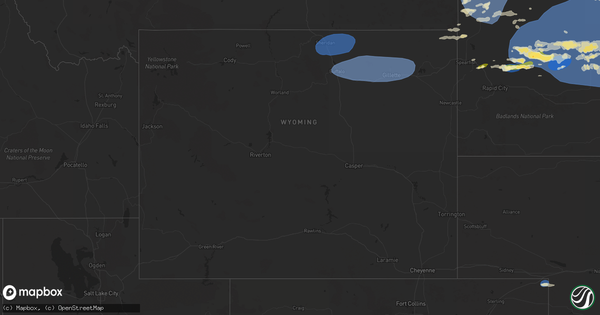
Hail Map in Wyoming on June 27, 2024
Get this storm
June 27 map
$229
one time, instant access
Download today. No call, no setup
Keep the $229
Bought the map and want the full workflow? Apply the entire $229 to a subscription within 7 days. None of it is wasted.
Every map, not just this one
This buys you this map. Subscription and you get every map we run, in the markets you choose from a few cities to whole states to nationwide. Plus real-time alerts the moment a storm fires.
Contact data
Name, contact info, occupancy, even credit band for addresses in the footprint. You go from where it hit to who to call.
Become the source they trust
Unlimited branding weather history reports on demand. You already have the documented answer ready for the property owner, and you are the one who showed up with it.
Property data and RoofTrace estimates
Pull up any address you have got, its value and the exact code rules for that jurisdiction, straight from One Click Code. Then RoofTrace estimates the squares, pitch, and roof value, priced the way you price.
Storm reports in Wyoming
Wyoming
| Date | Description |
|---|---|
| 06/27/20246:20 PM CDT | Time estimated based on radar |
| 06/27/20246:18 PM CDT | A local report indicates 59 MPH wind near 5 NNW Dwtn Gillette |
| 06/27/20246:12 PM CDT | Mesonet station wy3 ucross 28 se |
| 06/27/20246:02 PM CDT | Mesonet station wy3 ucross 28 se |
| 06/27/20245:53 PM CDT | Asos station kbyg buffalo airport. |
| 06/27/20244:56 PM CDT | Downed power lines and tree limbs. |
| 06/27/20244:56 PM CDT | Mesonet station wy55 2.9 n banner |
| 06/27/20244:49 PM CDT | A local report indicates 60 MPH wind near Big Horn |
| 06/27/20244:47 PM CDT | Asos station kshr sheridan. |
All States Impacted by Hail Map on June 27, 2024
Cities Impacted by Hail Map on June 27, 2024
- Flagstaff, AZ
- Sedona, AZ
- Winslow, AZ
- Belgrade, MT
- Manhattan, MT
- Manteo, NC
- Nags Head, NC
- Plymouth, NC
- Roper, NC
- Pantego, NC
- Pinetown, NC
- Creswell, NC
- Hartsville, SC
- Belhaven, NC
- Antimony, UT
- Big Timber, MT
- Ganado, AZ
- Concho, AZ
- Darlington, SC
- Fairfield, NC
- Melville, MT
- Scranton, NC
- Fredonia, AZ
- Merritt, NC
- White Oak, NC
- Colorado City, AZ
- Roundup, MT
- Bayboro, NC
- Grantsboro, NC
- New Bern, NC
- Elizabethtown, NC
- Ferron, UT
- Lavina, MT
- Maysville, NC
- Hanksville, UT
- Tohatchi, NM
- Musselshell, MT
- Crownpoint, NM
- Arapahoe, NC
- Wilmington, NC
- Boulder, UT
- Melstone, MT
- Ingomar, MT
- Shepherd, MT
- Hardin, MT
- Castle Hayne, NC
- Worden, MT
- Custer, MT
- Leupp, AZ
- Leland, NC
- Crow Agency, MT
- Kanab, UT
- Bighorn, MT
- Forsyth, MT
- Hysham, MT
- Grants, NM
- Holly Ridge, NC
- Price, UT
- Wellington, UT
- Myrtle Beach, SC
- Green River, UT
- Thompson, UT
- Monticello, UT
- Springer, NM
- Longs, SC
- Little River, SC
- Holly Hill, SC
- Otter, MT
- Ravenel, SC
- North Myrtle Beach, SC
- Huger, SC
- Hardeeville, SC
- Sneads Ferry, NC
- Moab, UT
- Cross, SC
- Okatie, SC
- Adams Run, SC
- Colstrip, MT
- Rosebud, MT
- Angela, MT
- Round O, SC
- Shonto, AZ
- Sturgis, SD
- Whitewood, SD
- Cordesville, SC
- Fort Meade, SD
- Lame Deer, MT
- Julesburg, CO
- Beach, ND
- Wibaux, MT
- Kinsey, MT
- Volborg, MT
- Georgetown, SC
- Moncks Corner, SC
- Page, AZ
- Richfield, UT
- Kenton, OK
- Buffalo, SD
- Meeker, CO
- Hathaway, MT
- Boise City, OK
- Saint Matthews, SC
- Venango, NE
- Miles City, MT
- Ismay, MT
- Rifle, CO
- Bedrock, CO
- Gateway, CO
- Hopkins, SC
- Gadsden, SC
- Monument Valley, UT
- New Underwood, SD
- Terry, MT
- Cartwright, ND
- Circle, MT
- Duchesne, UT
- Eastover, SC
- Enning, SD
- Medora, ND
- Whitewater, CO
- Grand Junction, CO
- Myton, UT
- Lambert, MT
- Wasta, SD
- Fairfield, ND
- Howes, SD
- Scenic, SD
- Hemingford, NE
- Caputa, SD
- Pine Ridge, SD
- Chadron, NE
- Owanka, SD
- Gordon, NE
- Porcupine, SD
- Kyle, SD
- Wall, SD
- Hermosa, SD
- Rapid City, SD
- Custer, SD
- Douglas, WY
- Newcastle, WY
- Lost Springs, WY
- Box Elder, SD
- Glendo, WY
- Manville, WY
- Edgemont, SD
- Keystone, SD
- Ellsworth Afb, SD
- Hill City, SD
- Shawnee, WY
- Lance Creek, WY
- Lusk, WY
- Savage, MT
- Richey, MT
- Gladstone, NM
- Glendive, MT
- Blanding, UT
- Roy, NM
- Wagon Mound, NM
- Solano, NM
- Patagonia, AZ
- Belfield, ND
- Elsie, NE
- Bloomfield, MT
- Clayton, NM
- Fallon, MT
- Sheridan, WY
- Ranchester, WY
- Banner, WY
- Clearmont, WY
- Big Horn, WY
- Wyarno, WY
- Story, WY
- Buffalo, WY
- Gillette, WY
- Arvada, WY
- Weston, WY
- Moorcroft, WY
- Rozet, WY
- Huntington, UT
- Montrose, CO
- Olathe, CO
- Kit Carson, CO
- Cheyenne Wells, CO
- Roosevelt, UT
- Hulett, WY
- Bowman, ND
- Camp Crook, SD
- Sentinel Butte, ND
- Rhame, ND
- Golva, ND
- Marmarth, ND
- Baker, MT
- Amidon, ND
- Plevna, MT
- South Heart, ND
- Scranton, ND
- Aladdin, WY
- Belle Fourche, SD
- Ludlow, SD
- Ephraim, UT
- Dickinson, ND
- New England, ND
- Fayette, UT
- Wales, UT
- Alzada, MT
- Whitman, NE
- Reva, SD
- Ralph, SD
- Grassy Butte, ND
- Arnegard, ND
- Manning, ND
- Killdeer, ND
- Reeder, ND
- Regent, ND
- Mott, ND
- Lefor, ND
- Hettinger, ND
- Newell, SD
- Prairie City, SD
- Lodgepole, SD
- Ekalaka, MT
- Gladstone, ND
- Taylor, ND
- Hooker, OK
- Hugoton, KS
- Liberal, KS
- Saint Onge, SD
- Tyrone, OK
- Turpin, OK
- Mud Butte, SD
- Lemmon, SD
- Meadow, SD
- Richardton, ND
- Mandaree, ND
- Dunn Center, ND
- Halliday, ND
- Dodge, ND
- Elgin, ND
- Beulah, ND
- Almont, ND
- Hebron, ND
- New Leipzig, ND
- Glen Ullin, ND
- Faith, SD
- Vale, SD
- Union Center, SD
- Wendover, UT
- Mona, UT
- White Owl, SD
- Nephi, UT
- Dupree, SD
- Forgan, OK
- Philip, SD
- Milesville, SD
- Cherry Creek, SD
- Lantry, SD
- Eagle Butte, SD
- Midland, SD
- Plains, KS
- Timber Lake, SD
- Isabel, SD
- McLaughlin, SD
- Morristown, SD
- Watauga, SD
- McIntosh, SD
- Keldron, SD
- Walker, SD
- Bullhead, SD
- Selfridge, ND
- Carson, ND
- Zap, ND
- Hazen, ND
- New Salem, ND
- Golden Valley, ND
- Center, ND
- Coldwater, KS
- Wilmore, KS
- Trail City, SD
- Glencross, SD
- Perryton, TX
- Fairview, UT
- Fort Pierre, SD
- Hayes, SD
- Balko, OK
- Mount Pleasant, UT
- Haviland, KS
- Lake City, KS
- Pierre, SD
- Sun City, KS
- Medicine Lodge, KS
- Agar, SD
- Gettysburg, SD
- Blunt, SD
- Onida, SD
- Hoven, SD
- Selby, SD
- Java, SD
- Bowdle, SD
- Tolstoy, SD
- Whitehorse, SD
- Ridgeview, SD
- Glenham, SD
- Akaska, SD
- Roscoe, SD
- Hosmer, SD
- Lebanon, SD
- Draper, SD
- Murdo, SD
- Okaton, SD
- Harrold, SD
- Kathryn, ND
- Leola, SD
- Onaka, SD
- Westport, SD
- Ipswich, SD
- Faulkton, SD
- Seneca, SD
- Highmore, SD
- Cresbard, SD
- Presho, SD
- Fort Thompson, SD
- Lower Brule, SD
- Stephan, SD
- Orient, SD
- Ree Heights, SD
- Vivian, SD
- Holabird, SD
- Miller, SD
- Shattuck, OK
- Gann Valley, SD
- Fargo, OK
- Gage, OK
- Reliance, SD
- Kennebec, SD
- Aberdeen, SD
- Rockham, SD
- Mansfield, SD
- Northville, SD
- Warner, SD
- Ashton, SD
- Andover, SD
- Mellette, SD
- Redfield, SD
- Saint Lawrence, SD
- Stratford, SD
- Groton, SD
- Tulare, SD
- Brentford, SD
- Ferney, SD
- Conde, SD
- Turton, SD
- Bath, SD
- Frankfort, SD
- Bristol, SD
- Doland, SD
- Webster, SD
- Huron, SD
- Hitchcock, SD
- Raymond, SD
- Wessington, SD
- Clark, SD
- Wolsey, SD
- Virgil, SD
- Wessington Springs, SD
- Canadian, TX
- Lipscomb, TX
- Follett, TX
- Booker, TX
- Higgins, TX
- Woodward, OK
- Sharon, OK
- Arnett, OK
- Mooreland, OK
- Washington, KS
- Hollenberg, KS
- Morrowville, KS
- Steele City, NE
- Endicott, NE
- Diller, NE
- Bradley, SD
- Waubay, SD
- Ortley, SD
- Bryant, SD
- Iroquois, SD
- De Smet, SD
- Alpena, SD
- Cavour, SD
- Garden City, SD
- Florence, SD
- Watertown, SD
- Carpenter, SD
- Henry, SD
- Willow Lake, SD
- Vienna, SD
- Wallace, SD
- Yale, SD
- Hazel, SD
- Woonsocket, SD
- Hardtner, KS
- Bremen, KS
- Odell, NE
- Wymore, NE
- Marysville, KS
- Hanover, KS
- Blue Springs, NE
- Oketo, KS


