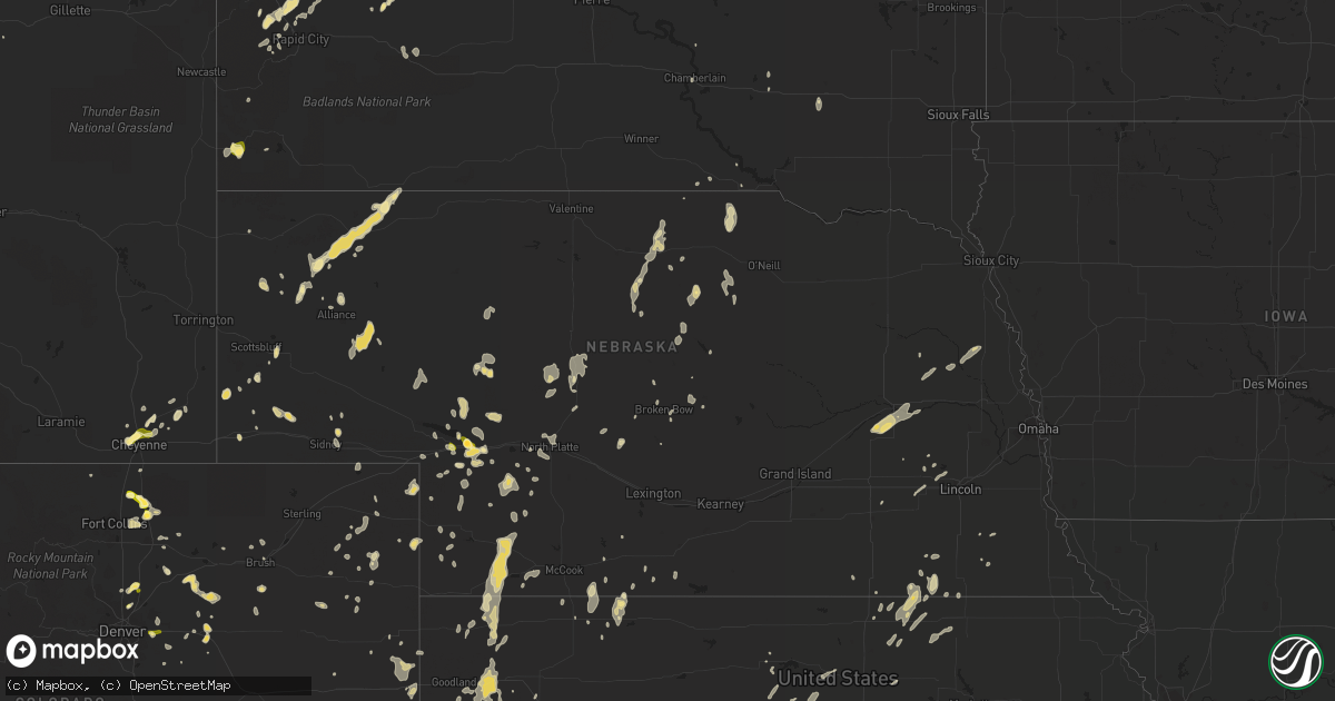
Hail Map in Nebraska on June 27, 2014
Get this storm
June 27 map
$229
one time, instant access
Download today. No call, no setup
Keep the $229
Bought the map and want the full workflow? Apply the entire $229 to a subscription within 7 days. None of it is wasted.
Every map, not just this one
This buys you this map. Subscription and you get every map we run, in the markets you choose from a few cities to whole states to nationwide. Plus real-time alerts the moment a storm fires.
Contact data
Name, contact info, occupancy, even credit band for addresses in the footprint. You go from where it hit to who to call.
Become the source they trust
Unlimited branding weather history reports on demand. You already have the documented answer ready for the property owner, and you are the one who showed up with it.
Property data and RoofTrace estimates
Pull up any address you have got, its value and the exact code rules for that jurisdiction, straight from One Click Code. Then RoofTrace estimates the squares, pitch, and roof value, priced the way you price.
Storm reports in Nebraska
Nebraska
| Date | Description |
|---|---|
| 06/27/20146:55 PM CDT | Relayed by emergency manager from hayes county - fire department reported power lines downed by high winds at the junction of highways 25 and 25a. Location approximatel |
| 06/27/20146:47 PM CDT | Hayes county emergency manager reported estimated 100 mph wind gusts. Large tree limbs down and very poor visibility in heavy rain. |
| 06/27/20146:45 PM CDT | Tree limbs downed...winds estimated at least 60 mph |
| 06/27/20146:27 PM CDT | Enclosed metal building had roughly 10 ft by 12 ft section of roof ripped off at the airport. Old farm windmill frame with mercury light on top was twisted and bent. |
| 06/27/20145:20 PM CDT | No estimate of speed but large tree branch down in her yard. Heavy rain falling sideways. |
| 06/26/201411:00 PM CDT | Tree limbs down near highway 12. Time estimated by radar |
| 06/26/201411:00 PM CDT | Trees down in ditches along highway 12. Time of report estimated from radar. |
| 06/26/201410:20 PM CDT | Peak wind gust at kvtn was 50 kts. |
| 06/26/201410:00 PM CDT | Delayed report from 6/27/14. Spotter reported that an ash tree was snapped in half. The tree had a diameter of 17 inches. Time of the event was estimated. |
| 06/26/20149:15 PM CDT | Trained spotter estimated winds to 60 mph. |
| 06/26/20149:00 PM CDT | A local report indicates 60 MPH wind near 4 SE PURDUM |
| 06/26/20149:00 PM CDT | Large tree limbs down |
| 06/26/20148:40 PM CDT | Pea size hail also reported |
| 06/26/20148:30 PM CDT | 4-6 inch tree branches down |
| 06/26/20148:25 PM CDT | A local report indicates 60 MPH wind near 12 NNW STAPLETON |
| 06/26/20148:06 PM CDT | Tree trunk snapped at hwy 30 and walnut st. |
| 06/26/20148:00 PM CDT | Estimated wind speeds of 50 to 60 mph |
| 06/26/20148:00 PM CDT | Delayed report...grain bin destroyed and moved 300-400 yards...time estimated by radar |
| 06/26/20147:55 PM CDT | Tree damage in sutherland. Trees reported flying by house. |
| 06/26/20147:54 PM CDT | Tree branches down - 8 inch branches blocking the road and 4 inch branches scattered about the road. |
| 06/26/20147:54 PM CDT | Tree branch of 8 inches in diameter down on north river road. |
| 06/26/20147:51 PM CDT | Tree branches of 4 to 6 inches in diameter down. |
| 06/26/20147:43 PM CDT | Delayed report...time estimated from radar...trees and power lines down in sutherland. |
| 06/26/20147:39 PM CDT | Delay report...time estimated from radar. Large tree limbs down in hershey. |
| 06/26/20147:34 PM CDT | A local report indicates 70 MPH wind near CURTIS |
| 06/26/20147:34 PM CDT | Power knocked out in sutherland. |
| 06/26/20147:30 PM CDT | 4 power poles reported snapped two miles west of wallace...near intersection of highway 23 and highway 25. |
| 06/26/20147:30 PM CDT | 4 power poles reported snapped two miles west of wallace...near intersection of highway 23 and highway 25. |
| 06/26/20147:25 PM CDT | A local report indicates 1.00 inch wind near OGALLALA |
| 06/26/20147:25 PM CDT | A local report indicates 1.50 inch wind near ROSCOE |
| 06/26/20147:22 PM CDT | A local report indicates 70 MPH wind near 20 S SUTHERLAND |
| 06/26/20147:20 PM CDT | Lots of tree damage being reported in wallace from thunderstorm wind gusts. Report relayed through dispatch. |
| 06/26/20147:15 PM CDT | A local report indicates 70 MPH wind near WALLACE |
| 06/26/20147:15 PM CDT | Delayed report...trees down in wallace and power lines across highway 23. |
All States Impacted by Hail Map on June 27, 2014
Cities Impacted by Hail Map on June 27, 2014
- Downs, KS
- Osborne, KS
- Dickens, NE
- Carr, CO
- Wellington, CO
- Clarendon, TX
- Harrisburg, NE
- Byers, CO
- McDonald, KS
- Mitchell, SD
- Ulysses, KS
- Fort Stockton, TX
- Fowler, KS
- Floral City, FL
- Inverness, FL
- Eaton, CO
- Fort Collins, CO
- Windsor, CO
- Wiggins, CO
- Aurora, CO
- Taylor, NE
- Roggen, CO
- Paxton, NE
- Ogallala, NE
- Pierce, CO
- Nunn, CO
- Rush, CO
- Cheyenne, WY
- Deadwood, SD
- Nemo, SD
- Edgemont, SD
- Wasta, SD
- Danbury, NE
- Keystone, NE
- Mclean, TX
- Ainsworth, NE
- Alliance, NE
- Piedmont, SD
- Sturgis, SD
- Endicott, NE
- Hollenberg, KS
- Akron, CO
- Midland, TX
- Rushville, NE
- Atkinson, NE
- Tryon, NE
- Arapahoe, CO
- Hemingford, NE
- Arthur, NE
- Lutz, FL
- Orlando, FL
- Stapleton, NE
- Fort Cobb, OK
- Diller, NE
- Steele City, NE
- Whitman, NE
- Tribune, KS
- Bellwood, NE
- Garden City, KS
- Bassett, NE
- Deerfield, KS
- Ulysses, NE
- Mills, NE
- Edison, NE
- Gladewater, TX
- Severance, CO
- Ault, CO
- Harrison, NE
- Brule, NE
- Calhan, CO
- Ramah, CO
- Weskan, KS
- Scott City, KS
- Edson, KS
- Colby, KS
- Levant, KS
- Brewster, KS
- Vinton, LA
- Hackberry, LA
- Sulphur, LA
- Pampa, TX
- Matador, TX
- Burlington, CO
- Idalia, CO
- Jennings, KS
- Osceola, NE
- Shelby, NE
- Mullen, NE
- Memphis, TX
- Kit Carson, CO
- Havelock, NC
- Fort Thompson, SD
- Bazine, KS
- Oberlin, KS
- Rush Center, KS
- La Crosse, KS
- Bison, KS
- Leakesville, MS
- Neely, MS
- Windermere, FL
- Walnut Hill, IL
- Centralia, IL
- Marsland, NE
- Hay Springs, NE
- Norton, KS
- Bridgeport, NE
- Oshkosh, NE
- Lakeside, NE
- Amelia, NE
- Dighton, KS
- Brush, CO
- Woodrow, CO
- Waterville, KS
- Hanover, KS
- Greenleaf, KS
- Barnes, KS
- Hedley, TX
- Lelia Lake, TX
- Brooklyn, MS
- Millry, AL
- Long Pine, NE
- Oakley, KS
- Dacono, CO
- Fort Lupton, CO
- Brighton, CO
- Sidney, NE
- West Point, NE
- Oakland, NE
- Floydada, TX
- Rosston, OK
- Rising City, NE
- David City, NE
- Schuyler, NE
- Columbus, NE
- Elsie, NE
- Childress, TX
- Faison, NC
- Minatare, NE
- Kershaw, SC
- Leoti, KS
- Sylvan Grove, KS
- Lucas, KS
- Lakin, KS
- Ingalls, KS
- Mobeetie, TX
- Quinn, SD
- Haddam, KS
- Morrowville, KS
- Dix, NE
- Hot Springs, SD
- Ransom, KS
- Holcomb, KS
- Burwell, NE
- Fairfax, SD
- Cimarron, KS
- Copeland, KS
- Simla, CO
- Sharon Springs, KS
- Rose Hill, KS
- Bennett, CO
- Fort Morgan, CO
- Wellington, TX
- Callaway, NE
- Nekoma, KS
- Chadron, NE
- Lakeview, TX
- New Underwood, SD
- Sebring, FL
- Julesburg, CO
- Kendall, KS
- Syracuse, KS
- Burns, WY
- Delco, NC
- Naper, NE
- Dix, IL
- Jetmore, KS
- Clifton, KS
- Clyde, KS
- Brooksville, FL
- Keenesburg, CO
- Rapid City, SD
- Marienthal, KS
- Cheyenne Wells, CO
- Potter, NE
- Kimball, NE
- Strasburg, CO
- Sentinel, OK
- Carter, OK
- Winona, KS
- Monument, KS
- Land O'Lakes, FL
- Satanta, KS
- Sublette, KS
- Uriah, AL
- Albin, WY
- Wimauma, FL
- Parrish, FL
- Munden, KS
- Belleville, KS
- Fairbury, NE
- Mahaska, KS
- Karval, CO
- Clarkson, NE
- Wray, CO
- Ness City, KS
- Beeler, KS
- Montezuma, IA
- El Reno, OK
- Orleans, NE
- Sun City Center, FL
- Narka, KS
- Madrid, NE
- Grant, NE
- Dalton, NE
- Elizabeth, CO
- Parker, CO
- Haxtun, CO
- Cambridge, NE
- Snyder, CO
- Stuart, NE
- Newell, SD
- Paoli, CO
- Holyoke, CO
- Union Center, SD
- Springview, NE
- Yoder, CO
- Broken Bow, NE
- Otis, CO
- Hayes Center, NE
- Pocasset, OK
- Silex, MO
- Hawk Point, MO
- Champion, NE
- Truxton, MO
- Bellflower, MO
- Beaumont, MS
- Max, NE
- Okeechobee, FL
- Custer, SD
- Jackson, AL
- Ensign, KS
- Dodge City, KS
- Thornton, CO
- Denver, CO
- Tipton, KS
- Shamrock, TX
- Burke, SD
- Gregory, SD
- Plymouth, NE
- Pierceville, KS
- Alzada, MT
- Seward, NE
- Milford, NE
- Avon Park, FL
- Wallace, NE
- Saint Francis, KS
- Trenton, NE
- Nakina, NC
- North Platte, NE
- Dodge, NE
- Howells, NE
- Buffalo, SD
- Anselmo, NE
- Magnolia, AL
- Pine Hill, AL
- White Lake, SD
- Gotebo, OK
- Andalusia, AL
- Ellsworth, NE
- Brady, NE
- Fe Warren Afb, WY
- Culbertson, NE
- Quitaque, TX
- Bushnell, NE
- Black Hawk, SD
- Yuma, CO
- Johnson, KS
- Wallace, KS
- Healy, KS
- Grinnell, KS
- Cordell, OK
- Groveland, FL
- Higgins, TX
- Imperial, NE
- Arcadia, NE
- Norcatur, KS
- Lebanon, NE
- Indianola, NE
- Merkel, TX
- Eustis, NE
- Adams, NE
- Seibert, CO
- Stratton, NE
- Wauneta, NE
- Palisade, NE
- Benkelman, NE
- Hunter, KS
- Gill, CO
- Hershey, NE
- Albert, KS
- Otis, KS
- Herrick, SD
- Bonesteel, SD
- Goodland, KS
- Briscoe, TX
- Gordon, NE
- Maple Hill, NC
- Kaycee, WY
- Gering, NE
- Carnegie, OK
- Bee, NE
- Garland, NE
- Venus, FL
- Belle Fourche, SD
- Sanibel, FL
- Eckley, CO
- Hubbell, NE
- Barnard, KS
- Lincoln, KS
- Jansen, NE
- Arcadia, FL
- Thomasville, AL
- Fleming, CO
- Westerville, NE
- Comstock, NE
- Erie, CO
- La Salle, CO
- Beloit, KS
- Sargent, NE
- Gove, KS
- Pleasant Dale, NE
- Malcolm, NE
- Greenback, TN
- Bird City, KS
- Wheeler, TX
- Meade, KS
- Newport, NC
- Oacoma, SD
- Wall, SD
- Justiceburg, TX
- Deshler, NE
- Lemoyne, NE
- Plains, KS
- Kirk, CO
- Geneva, FL
- Lake Charles, LA
- Buffalo, OK
- Spearville, KS
- Brownell, KS
- Miami, TX
- Hendley, NE
- Petersburg, TX
- Idalou, TX
- Meriden, WY
- Seymour, TN
- Maryville, TN
- Kissimmee, FL
- Okarche, OK
- Scribner, NE
- Snyder, NE
- Ashland, KS
- Exeter, NE
- Parks, NE
- Venango, NE
- Commerce City, CO
- Watkins, CO
- Snyder, TX
- Winter Park, FL
- Maitland, FL
- Greeley, CO
- Haswell, CO
- Filley, NE
- Punta Gorda, FL
- Canadian, TX
- Marysville, KS
- Odell, NE
- Kersey, CO
- Sterling, NE
- Lone Wolf, OK
- Osteen, FL
- Deltona, FL
- Agenda, KS
- Park, KS
- Burdett, KS
- Sayre, OK
- Schoenchen, KS
- Hays, KS
- McKenzie, AL
- Weldona, CO
- Livermore, CO
- Ethan, SD
- Gothenburg, NE
- Thedford, NE
- Collyer, KS
- Reva, SD
- Oconto, NE
- Lake Placid, FL
- Little River, AL
- Clay Center, KS
- Miltonvale, KS
- Mcpherson, KS
- Lewiston, NE
- Washington, KS
- Linn, KS
- Oxford, NE
- Beaver City, NE
- Calumet, OK
- Gurley, NE
- Cameron, LA
- Crook, CO
- Naples, FL
- Hanston, KS
- Erick, OK
- Fort Myers Beach, FL
- Gilbertown, AL
- Capitol, MT
- Claude, TX


