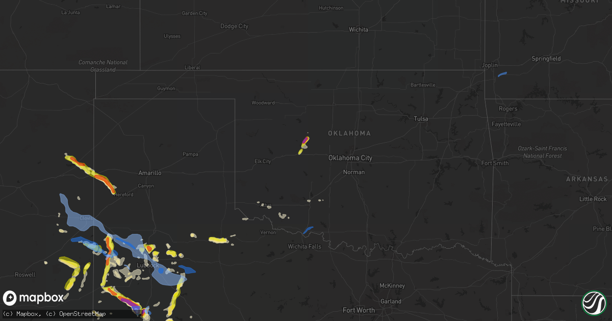
Hail Map in Oklahoma on June 26, 2021
Get this storm
June 26 map
$229
one time, instant access
Download today. No call, no setup
Keep the $229
Bought the map and want the full workflow? Apply the entire $229 to a subscription within 7 days. None of it is wasted.
Every map, not just this one
This buys you this map. Subscription and you get every map we run, in the markets you choose from a few cities to whole states to nationwide. Plus real-time alerts the moment a storm fires.
Contact data
Name, contact info, occupancy, even credit band for addresses in the footprint. You go from where it hit to who to call.
Become the source they trust
Unlimited branding weather history reports on demand. You already have the documented answer ready for the property owner, and you are the one who showed up with it.
Property data and RoofTrace estimates
Pull up any address you have got, its value and the exact code rules for that jurisdiction, straight from One Click Code. Then RoofTrace estimates the squares, pitch, and roof value, priced the way you price.
Storm reports in Oklahoma
Oklahoma
| Date | Description |
|---|---|
| 06/26/20214:54 PM CDT | Measured with handheld anemometer. Also noted various small limbs and shingles scattered throughout the neighborhood. |
| 06/26/20214:54 PM CDT | A local report indicates 1.00 inch wind near 1 ESE ELGIN |
| 06/26/20217:47 AM CDT | At 1247 AM CDT, severe thunderstorms were located along a line extending from 5 miles northwest of Sweetwater to 4 miles northeast of Lutie, moving east at 40 mph. HAZARD...60 mph wind gusts. SOURCE...Radar indicated. IMPACT...Expect damage to roofs, siding, and trees. Locations impacted include... Elk City, Sayre, Erick, Carter, Sweetwater, Texola, Delhi, Berlin and Dempsey. |
| 06/26/20217:26 AM CDT | At 1225 AM CDT, severe thunderstorms were located along a line extending from 4 miles southwest of Wheeler to 6 miles west of Dozier to 5 miles northwest of Memphis, moving east at 35 mph. HAZARD...70 mph wind gusts and quarter size hail. SOURCE...Automated weather equipment. At 1215 AM CDT, automated weather equipment recorded a 68 mph wind gust 1 mile east of Mclean. IMPACT...Expect some tree damage. Damage is likely to mobile homes, roofs, and outbuildings. Hail damage to vehicles is expected. Locations impacted include... Wellington, Shamrock, Dodson, Lutie, Twitty, Dozier, Lela, Quail and Samnorwood. |
| 06/26/20211:45 AM CDT | At 645 PM CDT, a severe thunderstorm was located 7 miles west of Greenfield, moving northeast at 20 mph. HAZARD...60 mph wind gusts and quarter size hail. SOURCE...Radar indicated. IMPACT...Hail damage to vehicles is expected. Expect wind damage to roofs, siding, and trees. Locations impacted include... Watonga and Greenfield. |
| 06/26/20211:39 AM CDT | At 639 AM CDT, a severe thunderstorm was located 6 miles north of Porter, moving east at 40 mph. HAZARD...60 mph wind gusts. SOURCE...Radar indicated. IMPACT...Expect damage to roofs, siding, and trees. Locations in or near the path include... Wagoner... Hulbert... Lost City... |
| 06/26/20211:20 AM CDT | At 620 PM CDT, a severe thunderstorm was located near Hydro, moving northeast at 20 mph. HAZARD...60 mph wind gusts and quarter size hail. SOURCE...Radar indicated. IMPACT...Hail damage to vehicles is expected. Expect wind damage to roofs, siding, and trees. Locations impacted include... Geary and Hydro. |
| 06/26/202112:48 AM CDT | At 548 PM CDT, severe thunderstorms were located along a line extending from 5 miles south of Snyder to 4 miles northwest of Frederick, moving east at 15 mph. HAZARD...60 mph wind gusts and quarter size hail. SOURCE...Radar indicated. IMPACT...Hail damage to vehicles is expected. Expect wind damage to roofs, siding, and trees. Locations impacted include... Frederick, Snyder, Tipton, Indiahoma, Manitou and Hollister. |
| 06/25/202111:55 PM CDT | At 455 PM CDT, a severe thunderstorm was located near Humphreys, moving east at 15 mph. HAZARD...60 mph wind gusts and quarter size hail. SOURCE...Radar indicated. IMPACT...Hail damage to vehicles is expected. Expect wind damage to roofs, siding, and trees. Locations impacted include... Altus, Tipton, Headrick, Altus Air Force Base and Humphreys. |
| 06/25/202111:14 PM CDT | Measured at altus afb. |
| 06/25/202110:52 PM CDT | At 352 AM CDT, severe thunderstorms were located along a line extending from near Guthrie to near Edmond to near Oklahoma City, moving east at 35 mph. HAZARD...70 mph wind gusts. SOURCE...Radar indicated. IMPACT...Expect considerable tree damage. Damage is likely to mobile homes, roofs, and outbuildings. Locations impacted include... Oklahoma City, northeastern Norman, Edmond, Moore, Midwest City, Del City, Guthrie, Bethany, Choctaw, Warr Acres, The Village, Harrah, McLoud, Spencer, Nichols Hills, Jones, Nicoma Park, Luther, Cashion and Wellston. |
| 06/25/202110:14 PM CDT | At 314 AM CDT, severe thunderstorms were located along a line extending from 10 miles south of Loyal to 3 miles northwest of El Reno to 6 miles west of Union City, moving east at 40 mph. HAZARD...60 mph wind gusts. SOURCE...Radar indicated. IMPACT...Expect damage to roofs, siding, and trees. Locations impacted include... Oklahoma City, western Edmond, Del City, El Reno, Guthrie, Kingfisher, Yukon, Bethany, Mustang, Warr Acres, The Village, Piedmont, Nichols Hills, Union City, Okarche, Cashion, Calumet, Cedar Valley, Cimarron City and Concho. |
| 06/25/20219:40 PM CDT | At 239 AM CDT, severe thunderstorms were located along a line extending from 9 miles west of Greenfield to 8 miles southwest of Hinton to near Carnegie, moving east at 35 mph. HAZARD...60 mph wind gusts. SOURCE...Radar indicated. IMPACT...Expect damage to roofs, siding, and trees. Locations impacted include... El Reno, Hinton, Carnegie, Union City, Minco, Geary, Hydro, Binger, Fort Cobb, Calumet, Eakly, Gracemont, Lookeba, Bridgeport, Greenfield, Cogar, Alfalfa, Concho, Fort Cobb Reservoir and Albert. |
| 06/25/20218:55 PM CDT | At 154 AM CDT, severe thunderstorms were located along a line extending from near Custer City to 3 miles south of Bessie to 4 miles southwest of Rocky, moving east at 45 mph. HAZARD...70 mph wind gusts and quarter size hail. SOURCE...The Clinton ASOS reported a 77 mph wind gust at 1:45 AM. IMPACT...Hail damage to vehicles is expected. Expect considerable tree damage. Wind damage is also likely to mobile homes, roofs, and outbuildings. Locations impacted include... Weatherford, Clinton, Hobart, Cordell, Hinton, Burns Flat, Carnegie, Geary, Thomas, Hydro, Sentinel, Arapaho, Mountain View, Binger, Fort Cobb, Dill City, Corn, Custer City, Eakly and Gotebo. |
| 06/25/20218:19 PM CDT | At 118 AM CDT, severe thunderstorms were located along a line extending from 3 miles west of Butler to near Canute to 7 miles south of Delhi, moving east at 25 mph. HAZARD...60 mph wind gusts and penny size hail. SOURCE...Radar indicated. IMPACT...Expect damage to roofs, siding, and trees. Locations impacted include... Elk City, Clinton, Cordell, Burns Flat, Sentinel, Arapaho, Dill City, Canute, Corn, Custer City, Butler, Carter, Bessie, Rocky, Foss, Willow, Retrop, Foss Reservoir and Stafford. |
All States Impacted by Hail Map on June 26, 2021
Cities Impacted by Hail Map on June 26, 2021
- Levelland, TX
- Abernathy, TX
- Idalou, TX
- Lubbock, TX
- Stanton, TX
- Jal, NM
- Brownfield, TX
- Loop, TX
- Paducah, TX
- Midland, TX
- Odessa, TX
- Tatum, NM
- Monahans, TX
- Maple, TX
- Sudan, TX
- Causey, NM
- Rogers, NM
- Lenorah, TX
- Tarzan, TX
- Ralls, TX
- Roswell, NM
- Shallowater, TX
- Lamesa, TX
- San Jon, NM
- Logan, NM
- Mosquero, NM
- Watonga, OK
- Morton, TX
- Crossroads, NM
- Matador, TX
- Floydada, TX
- Plains, TX
- Hereford, TX
- Welch, TX
- Seagraves, TX
- Muleshoe, TX
- Enochs, TX
- Lovington, NM
- Bard, NM
- Denver City, TX
- Crane, TX
- Big Spring, TX
- Gardendale, TX
- Geary, OK
- Whiteface, TX
- Frederick, OK
- Loveland, OK
- Crowell, TX
- Lorenzo, TX
- Meadow, TX
- Floyd, NM
- Post, TX
- Crosbyton, TX
- Marathon, TX
- Elida, NM
- Sterling City, TX
- Adrian, TX
- Seminole, TX
- Duke, OK
- Garita, NM
- Quanah, TX
- Tahoka, TX
- Altus, OK
- Andrews, TX
- Coahoma, TX
- Gail, TX
- Hale Center, TX
- Justiceburg, TX
- Fluvanna, TX
- Ackerly, TX
- Bokeelia, FL
- Hydro, OK
- Elgin, OK
- Lawton, OK
- Fort Sill, OK
- Littlefield, TX
- Amherst, TX
- Westbrook, TX
- Snyder, TX
- Hobbs, NM
- Ropesville, TX
- Sundown, TX
- Wolfforth, TX
- Portales, NM
- Mcdonald, NM
- Colorado City, TX
- Saint James City, FL
- McCamey, TX
- Fletcher, OK
- Wink, TX
- Pyote, TX
- Wilson, TX
- Grady, NM
- Weldon, IL
- Farmer City, IL
- Eunice, NM
- Naples, FL
- Kermit, TX
- Anton, TX
- Englewood, FL
- Venice, FL
- Goldsmith, TX
- Sarasota, FL
- Nokomis, FL
- Grandfalls, TX
- Milnesand, NM
- Pep, TX
- South Bend, IN
- Mishawaka, IN
- Culver, IN
- Medaryville, IN
- Winamac, IN
- Knox, IN
- North Judson, IN
- Francesville, IN
- Rensselaer, IN
- Monterey, IN
- Ora, IN
- Buffalo, IN
- Star City, IN
- Reynolds, IN
- Wolcott, IN
- Monticello, IN
- Monon, IN
- Earl Park, IN
- Fowler, IN
- Goodland, IN
- Remington, IN
- Neosho, MO
- Stark City, MO
- Granby, MO
- Pierce City, MO
- Spur, TX
- Texico, NM
- Fieldton, TX
- Ransom Canyon, TX
- Mcalister, NM
- Clovis, NM
- Olton, TX
- Tucumcari, NM
- Melrose, NM
- Cannon Afb, NM
- Farwell, TX
- Slaton, TX
- Temple, OK
- Randlett, OK
- Mecosta, MI
- Morley, MI
- Remus, MI
- Lakeview, MI
- Blanchard, MI
- Weidman, MI
- Farwell, MI
- Freeport, MI
- Portland, MI
- Lake Odessa, MI
- Three Rivers, MI
- Vandalia, MI
- Jones, MI
- Cassopolis, MI
- Charlotte, MI
- Eaton Rapids, MI
- Holt, MI
- Dimondale, MI
- Mason, MI
- Jackson, MI
- Stockbridge, MI
- Grass Lake, MI
- Chelsea, MI
- Parma, MI
- Spring Arbor, MI
- Munith, MI
- Chicago, IL
- South Wilmington, IL
- Gardner, IL
- Dwight, IL
- Braidwood, IL
- Wilmington, IL
- Essex, IL
- Long Point, IL
- Blackstone, IL
- Streator, IL
- Flanagan, IL
- Cornell, IL
- Odell, IL
- Minonk, IL
- Pontiac, IL
- Cooksville, IL
- Bloomington, IL
- Forrest, IL
- Cropsey, IL
- Fairbury, IL
- Alsip, IL
- Evergreen Park, IL
- Alexander, IL
- Roodhouse, IL
- Murrayville, IL
- Jacksonville, IL
- Hillview, IL
- Winchester, IL
- Franklin, IL
- Palmyra, IL
- White Hall, IL
- Wrights, IL
- Greenfield, IL
- Cantrall, IL
- Williamsville, IL
- Sherman, IL
- Springfield, IL
- Chenoa, IL
- Momence, IL
- Chatsworth, IL
- Wanatah, IN
- Normal, IL
- Wheatfield, IN
- Clifton, IL
- Lexington, IL
- Arrowsmith, IL
- Mendon, MI
- Colfax, IL
- Lake Village, IN
- Ellsworth, IL
- Atlanta, IL
- Constantine, MI
- Roberts, IL
- Plymouth, IN
- Papineau, IL
- Valparaiso, IN
- Heyworth, IL
- Danforth, IL
- Hebron, IN
- Lincoln, IL
- San Pierre, IN
- Demotte, IN
- Bremen, IN
- Hamlet, IN
- Sibley, IL
- Gibson City, IL
- La Crosse, IN
- Boone Grove, IN
- Niles, MI
- Pembroke Township, IL
- McLean, IL
- Kouts, IN
- White Pigeon, MI
- Ashkum, IL
- Martinton, IL
- Bristol, IN
- Elkhart, IN
- Grovertown, IN
- Saybrook, IL
- Lowell, IN
- North Liberty, IN
- Watseka, IL
- Clinton, IL
- Melvin, IL
- Beason, IL
- Granger, IN
- Shelby, IN
- Union, MI
- Thayer, IN
- Walkerton, IN
- Le Roy, IL
- Anchor, IL
- Downs, IL
- Morocco, IN
- Wapella, IL
- Gilman, IL
- Centreville, MI
- Edwardsburg, MI
- Donovan, IL
- Lakeville, IN
- Sturgis, MI
- Piper City, IL
- Onarga, IL
- Beaverville, IL
- Fair Oaks, IN
- Strawn, IL
- Osceola, IN
- Saint Anne, IL
- Hanna, IN
- Waynesville, IL
- Elkhart, IL
- Buffalo, IL
- Riverton, IL
- Dyer, IN
- Beecher, IL
- Crete, IL
- Bellflower, IL
- Champaign, IL
- Dewey, IL
- Rantoul, IL
- Thomasboro, IL


