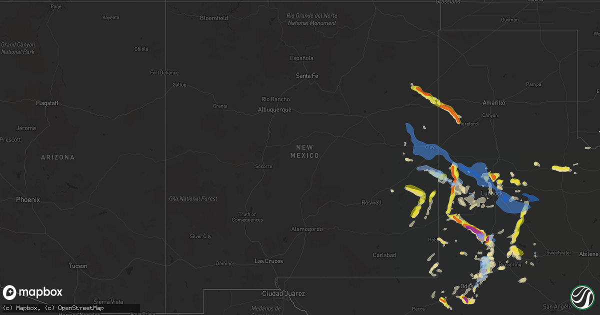
Hail Map in New Mexico on June 26, 2021
Get this storm
June 26 map
$229
one time, instant access
Download today. No call, no setup
Keep the $229
Bought the map and want the full workflow? Apply the entire $229 to a subscription within 7 days. None of it is wasted.
Every map, not just this one
This buys you this map. Subscription and you get every map we run, in the markets you choose from a few cities to whole states to nationwide. Plus real-time alerts the moment a storm fires.
Contact data
Name, contact info, occupancy, even credit band for addresses in the footprint. You go from where it hit to who to call.
Become the source they trust
Unlimited branding weather history reports on demand. You already have the documented answer ready for the property owner, and you are the one who showed up with it.
Property data and RoofTrace estimates
Pull up any address you have got, its value and the exact code rules for that jurisdiction, straight from One Click Code. Then RoofTrace estimates the squares, pitch, and roof value, priced the way you price.
Storm reports in New Mexico
New Mexico
| Date | Description |
|---|---|
| 06/26/20216:55 PM CDT | Kcvs asos. |
| 06/26/20216:45 PM CDT | Powerlines down across town on commercial st and us70 & kilgore north of town. |
| 06/26/20215:30 PM CDT | A local report indicates 80 MPH wind near 1 N LOGAN |
| 06/26/20215:00 PM CDT | A local report indicates 1.00 inch wind near LOGAN |
| 06/26/20215:00 PM CDT | A local report indicates 70 MPH wind near LOGAN |
| 06/26/20215:00 PM CDT | Semi-truck blown over on us-54. Mesquite bushes about 4 feet tall snapped in half. |
| 06/26/20214:52 PM CDT | Several mobile homes with missing siding... Windows broken out... Holes in siding due to wind driven hail. Metal roofing peeled back on mobile homes. |
| 06/26/20214:50 PM CDT | Estimated pea size to quarter size hail. Hail was wind driven. Hail accumulated to 1ft drifts at times. |
| 06/26/202112:25 AM CDT | At 525 PM MDT, a severe thunderstorm was located near Elkins, or 31 miles northeast of Roswell, moving east at 20 mph. HAZARD...Ping pong ball size hail and 60 mph wind gusts. SOURCE...Radar indicated. IMPACT...People and animals outdoors will be injured. Expect hail damage to roofs, siding, windows, and vehicles. Expect wind damage to roofs, siding, and trees. Locations impacted include... Elkins.This includes Highway 380 between Mile Markers 193 and 196. |
| 06/26/202112:08 AM CDT | At 508 PM MDT, severe thunderstorms were located along a line extending from 9 miles northwest of Saint Vrain to near Melrose, moving east at 40 mph. HAZARD...70 mph wind gusts. SOURCE...Radar indicated. IMPACT...Expect considerable tree damage. Damage is likely to mobile homes, roofs, and outbuildings. Locations impacted include... Portales, Melrose, Floyd, Saint Vrain, Cannon Air Force Base, Arch and Oasis State Park.This includes Highway 60 between Mile Markers 358 and 379. |
| 06/25/202111:07 PM CDT | At 405 PM MDT, severe thunderstorms were located along a line extending from 7 miles west of Tucumcari to 10 miles west of Quay to 10 miles northwest of House, moving southeast at 30 mph. Outflow winds along the gust front ahead of the storms could reach 60 mph. HAZARD...60 mph wind gusts. SOURCE...Radar indicated. IMPACT...Expect damage to roofs, siding, and trees. Locations impacted include... Quay, Tucumcari, San Jon, House, Ragland, Wheatland, Forrest and Mcalister.This includes the following highways... Interstate 40 between Mile Markers 317 and 358. State Road 104 between Mile Markers 104 and 105. |
| 06/25/202110:30 PM CDT | At 329 PM MDT, a severe thunderstorm was located near Ute Lake State Park, or 21 miles northeast of Tucumcari, moving southeast at 20 mph. HAZARD...60 mph wind gusts and quarter size hail. SOURCE...Radar indicated. IMPACT...Hail damage to vehicles is expected. Expect wind damage to roofs, siding, and trees. Locations impacted include... Tucumcari, Logan and Ute Lake State Park. This includes Interstate 40 between Mile Markers 335 and 344. |
| 06/25/20217:55 PM CDT | Tatum mesonet measured a wind gust of 59 mph. |
| 06/25/20217:19 PM CDT | Kcvn awos. |
| 06/25/20217:13 PM CDT | Kcvn awos. |
| 06/25/20217:10 PM CDT | A local report indicates 62 MPH wind near 2 SE CLOVIS |
All States Impacted by Hail Map on June 26, 2021
Cities Impacted by Hail Map on June 26, 2021
- Levelland, TX
- Abernathy, TX
- Idalou, TX
- Lubbock, TX
- Stanton, TX
- Jal, NM
- Brownfield, TX
- Loop, TX
- Paducah, TX
- Midland, TX
- Odessa, TX
- Tatum, NM
- Monahans, TX
- Maple, TX
- Sudan, TX
- Causey, NM
- Rogers, NM
- Lenorah, TX
- Tarzan, TX
- Ralls, TX
- Roswell, NM
- Shallowater, TX
- Lamesa, TX
- San Jon, NM
- Logan, NM
- Mosquero, NM
- Watonga, OK
- Morton, TX
- Crossroads, NM
- Matador, TX
- Floydada, TX
- Plains, TX
- Hereford, TX
- Welch, TX
- Seagraves, TX
- Muleshoe, TX
- Enochs, TX
- Lovington, NM
- Bard, NM
- Denver City, TX
- Crane, TX
- Big Spring, TX
- Gardendale, TX
- Geary, OK
- Whiteface, TX
- Frederick, OK
- Loveland, OK
- Crowell, TX
- Lorenzo, TX
- Meadow, TX
- Floyd, NM
- Post, TX
- Crosbyton, TX
- Marathon, TX
- Elida, NM
- Sterling City, TX
- Adrian, TX
- Seminole, TX
- Duke, OK
- Garita, NM
- Quanah, TX
- Tahoka, TX
- Altus, OK
- Andrews, TX
- Coahoma, TX
- Gail, TX
- Hale Center, TX
- Justiceburg, TX
- Fluvanna, TX
- Ackerly, TX
- Bokeelia, FL
- Hydro, OK
- Elgin, OK
- Lawton, OK
- Fort Sill, OK
- Littlefield, TX
- Amherst, TX
- Westbrook, TX
- Snyder, TX
- Hobbs, NM
- Ropesville, TX
- Sundown, TX
- Wolfforth, TX
- Portales, NM
- Mcdonald, NM
- Colorado City, TX
- Saint James City, FL
- McCamey, TX
- Fletcher, OK
- Wink, TX
- Pyote, TX
- Wilson, TX
- Grady, NM
- Weldon, IL
- Farmer City, IL
- Eunice, NM
- Naples, FL
- Kermit, TX
- Anton, TX
- Englewood, FL
- Venice, FL
- Goldsmith, TX
- Sarasota, FL
- Nokomis, FL
- Grandfalls, TX
- Milnesand, NM
- Pep, TX
- South Bend, IN
- Mishawaka, IN
- Culver, IN
- Medaryville, IN
- Winamac, IN
- Knox, IN
- North Judson, IN
- Francesville, IN
- Rensselaer, IN
- Monterey, IN
- Ora, IN
- Buffalo, IN
- Star City, IN
- Reynolds, IN
- Wolcott, IN
- Monticello, IN
- Monon, IN
- Earl Park, IN
- Fowler, IN
- Goodland, IN
- Remington, IN
- Neosho, MO
- Stark City, MO
- Granby, MO
- Pierce City, MO
- Spur, TX
- Texico, NM
- Fieldton, TX
- Ransom Canyon, TX
- Mcalister, NM
- Clovis, NM
- Olton, TX
- Tucumcari, NM
- Melrose, NM
- Cannon Afb, NM
- Farwell, TX
- Slaton, TX
- Temple, OK
- Randlett, OK
- Mecosta, MI
- Morley, MI
- Remus, MI
- Lakeview, MI
- Blanchard, MI
- Weidman, MI
- Farwell, MI
- Freeport, MI
- Portland, MI
- Lake Odessa, MI
- Three Rivers, MI
- Vandalia, MI
- Jones, MI
- Cassopolis, MI
- Charlotte, MI
- Eaton Rapids, MI
- Holt, MI
- Dimondale, MI
- Mason, MI
- Jackson, MI
- Stockbridge, MI
- Grass Lake, MI
- Chelsea, MI
- Parma, MI
- Spring Arbor, MI
- Munith, MI
- Chicago, IL
- South Wilmington, IL
- Gardner, IL
- Dwight, IL
- Braidwood, IL
- Wilmington, IL
- Essex, IL
- Long Point, IL
- Blackstone, IL
- Streator, IL
- Flanagan, IL
- Cornell, IL
- Odell, IL
- Minonk, IL
- Pontiac, IL
- Cooksville, IL
- Bloomington, IL
- Forrest, IL
- Cropsey, IL
- Fairbury, IL
- Alsip, IL
- Evergreen Park, IL
- Alexander, IL
- Roodhouse, IL
- Murrayville, IL
- Jacksonville, IL
- Hillview, IL
- Winchester, IL
- Franklin, IL
- Palmyra, IL
- White Hall, IL
- Wrights, IL
- Greenfield, IL
- Cantrall, IL
- Williamsville, IL
- Sherman, IL
- Springfield, IL
- Chenoa, IL
- Momence, IL
- Chatsworth, IL
- Wanatah, IN
- Normal, IL
- Wheatfield, IN
- Clifton, IL
- Lexington, IL
- Arrowsmith, IL
- Mendon, MI
- Colfax, IL
- Lake Village, IN
- Ellsworth, IL
- Atlanta, IL
- Constantine, MI
- Roberts, IL
- Plymouth, IN
- Papineau, IL
- Valparaiso, IN
- Heyworth, IL
- Danforth, IL
- Hebron, IN
- Lincoln, IL
- San Pierre, IN
- Demotte, IN
- Bremen, IN
- Hamlet, IN
- Sibley, IL
- Gibson City, IL
- La Crosse, IN
- Boone Grove, IN
- Niles, MI
- Pembroke Township, IL
- McLean, IL
- Kouts, IN
- White Pigeon, MI
- Ashkum, IL
- Martinton, IL
- Bristol, IN
- Elkhart, IN
- Grovertown, IN
- Saybrook, IL
- Lowell, IN
- North Liberty, IN
- Watseka, IL
- Clinton, IL
- Melvin, IL
- Beason, IL
- Granger, IN
- Shelby, IN
- Union, MI
- Thayer, IN
- Walkerton, IN
- Le Roy, IL
- Anchor, IL
- Downs, IL
- Morocco, IN
- Wapella, IL
- Gilman, IL
- Centreville, MI
- Edwardsburg, MI
- Donovan, IL
- Lakeville, IN
- Sturgis, MI
- Piper City, IL
- Onarga, IL
- Beaverville, IL
- Fair Oaks, IN
- Strawn, IL
- Osceola, IN
- Saint Anne, IL
- Hanna, IN
- Waynesville, IL
- Elkhart, IL
- Buffalo, IL
- Riverton, IL
- Dyer, IN
- Beecher, IL
- Crete, IL
- Bellflower, IL
- Champaign, IL
- Dewey, IL
- Rantoul, IL
- Thomasboro, IL


