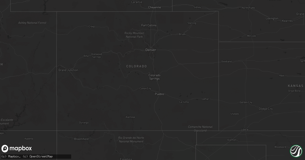
Hail Map in Texas on June 26, 2012
Get this storm
June 26 map
$229
one time, instant access
Download today. No call, no setup
Keep the $229
Bought the map and want the full workflow? Apply the entire $229 to a subscription within 7 days. None of it is wasted.
Every map, not just this one
This buys you this map. Subscription and you get every map we run, in the markets you choose from a few cities to whole states to nationwide. Plus real-time alerts the moment a storm fires.
Contact data
Name, contact info, occupancy, even credit band for addresses in the footprint. You go from where it hit to who to call.
Become the source they trust
Unlimited branding weather history reports on demand. You already have the documented answer ready for the property owner, and you are the one who showed up with it.
Property data and RoofTrace estimates
Pull up any address you have got, its value and the exact code rules for that jurisdiction, straight from One Click Code. Then RoofTrace estimates the squares, pitch, and roof value, priced the way you price.
Storm reports in Texas
Texas
| Date | Description |
|---|---|
| 06/26/20126:55 PM CDT | Several trees blown down north of the city. |
| 06/26/20125:45 PM CDT | Trees and power lines down. |
| 06/26/20123:45 PM CDT | 4 hangers damaged at the west houston airport. |
| 06/26/201212:40 AM CDT | Widespread damage in town to a number of roofs... Trees... Walls and telephone poles. |
| 06/25/201210:34 PM CDT | Tree blown down onto car |
| 06/25/201210:17 PM CDT | Numerous tree limbs blown down and some homes damaged. |
| 06/25/201210:15 PM CDT | Marble size hail and numerous large tree limbs scattered across ih37. |
| 06/25/20128:45 PM CDT | Porch blown off mobile home and large tree down |
| 06/25/20127:38 PM CDT | Marble size hail and several trees limbs blown down. |
| 06/25/20127:38 PM CDT | Marble size hail and several trees limbs blown down. |
| 06/25/20127:38 PM CDT | Marble size hail and several trees limbs blown down. |
| 06/25/20127:20 PM CDT | Metal tin was blown off an old barn and several large tree limbs were blown down. |
| 06/25/20127:00 PM CDT | Several trees blown down in and around schulenburg... Mainly north of the city on highway 77. |
All States Impacted by Hail Map on June 26, 2012
Cities Impacted by Hail Map on June 26, 2012
- Epping, ND
- Williston, ND
- Ray, ND
- Flatonia, TX
- Cartwright, ND
- Havre, MT
- Whitsett, TX
- Calliham, TX
- Three Rivers, TX
- Grassy Butte, ND
- Watford City, ND
- Killdeer, ND
- Rudyard, MT
- Beeville, TX
- George West, TX
- Lansford, ND
- Whitetail, MT
- Skidmore, TX
- Mathis, TX
- Tynan, TX
- Hallettsville, TX
- Fort Benton, MT
- Kalispell, MT
- Bigfork, MT
- Somers, MT
- Conrad, MT
- Joplin, MT
- Gildford, MT
- Ledger, MT
- Hingham, MT
- Chester, MT
- Inverness, MT
- Richey, MT
- Lambert, MT
- New Town, ND
- Tioga, ND
- Houston, TX
- Trinity, TX
- Kenmare, ND
- Sherwood, ND
- Mohall, ND
- Tolley, ND
- Arnegard, ND
- Circle, MT
- Bloomfield, MT
- Brockway, MT
- Savage, MT
- Sidney, MT
- Fairview, MT
- East Glacier Park, MT
- Essex, MT
- Ashby, NE
- Power, MT
- Floweree, MT
- Carter, MT
- Great Falls, MT
- Ovando, MT
- Sweet Grass, MT
- Shelby, MT
- Sunburst, MT
- Kevin, MT
- Schulenburg, TX
- Parshall, ND
- Whitlash, MT
- Big Sandy, MT
- Chinook, MT
- Dutton, MT
- Galata, MT
- Kremlin, MT
- Brady, MT
- Cut Bank, MT
- Marion, MT
- Plentywood, MT
- Pleasanton, TX
- Poteet, TX
- Voltaire, ND
- Benedict, ND
- Velva, ND
- Sawyer, ND
- Max, ND
- Kenedy, TX
- Karnes City, TX
- Gillett, TX
- Hobson, TX
- Westby, MT
- Cypress, TX
- Katy, TX
- Alexander, ND
- Falls City, TX
- Mandaree, ND
- Keene, ND
- Loma, MT
- Waelder, TX
- Lakeside, MT
- Amado, AZ
- Valier, MT
- Floresville, TX
- Bigfoot, TX
- Charlotte, TX
- Campbellton, TX
- Poth, TX
- Browning, MT
- Weimar, TX
- Columbus, TX
- Goliad, TX
- Harwood, TX
- Sun River, MT
- Cascade, MT
- Berthold, ND
- Oilmont, MT
- Raymond, MT
- Cat Spring, TX
- Needville, TX
- Boling, TX
- Douglas, ND
- Ryder, ND
- Makoti, ND
- Richmond, TX
- Lewellen, NE
- Lincoln, MT
- Stanley, ND
- Palermo, ND
- Alto, TX
- Grapeland, TX
- Wells, TX
- Minot, ND
- Rosenberg, TX
- Bellville, TX
- Runge, TX
- Plaza, ND
- Comfort, TX
- Muldoon, TX
- Fredericksburg, TX
- Vaughn, MT
- Powers Lake, ND
- White Earth, ND
- Balfour, ND
- Groveton, TX
- Anamoose, ND
- Drake, ND
- Montgomery, TX
- Donnybrook, ND
- Carpio, ND
- Bottineau, ND
- Huntsville, TX
- Outlook, MT
- Glidden, TX
- San Diego, TX
- Sinton, TX
- Scranton, ND
- Beach, ND
- Navasota, TX
- Souris, ND
- Victoria, TX
- Bingham, NE
- Maxbass, ND


