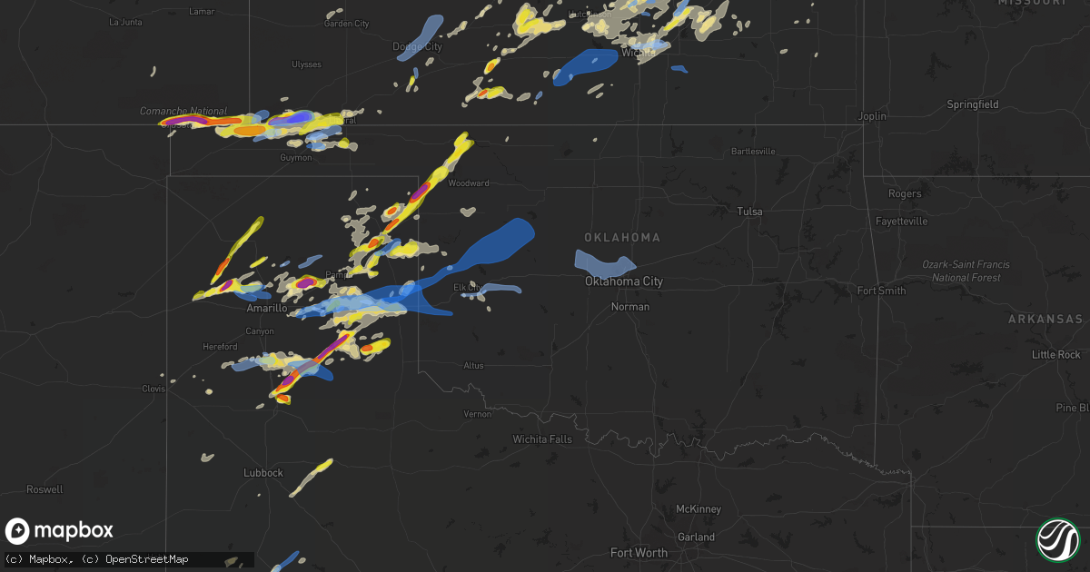
Hail Map in Oklahoma on June 25, 2021
Get this storm
June 25 map
$229
one time, instant access
Download today. No call, no setup
Keep the $229
Bought the map and want the full workflow? Apply the entire $229 to a subscription within 7 days. None of it is wasted.
Every map, not just this one
This buys you this map. Subscription and you get every map we run, in the markets you choose from a few cities to whole states to nationwide. Plus real-time alerts the moment a storm fires.
Contact data
Name, contact info, occupancy, even credit band for addresses in the footprint. You go from where it hit to who to call.
Become the source they trust
Unlimited branding weather history reports on demand. You already have the documented answer ready for the property owner, and you are the one who showed up with it.
Property data and RoofTrace estimates
Pull up any address you have got, its value and the exact code rules for that jurisdiction, straight from One Click Code. Then RoofTrace estimates the squares, pitch, and roof value, priced the way you price.
Storm reports in Oklahoma
Oklahoma
| Date | Description |
|---|---|
| 06/25/20216:21 PM CDT | Corrects previous tstm wnd gst report from hooker. 74 knot winds recorded at hooker mesonet. |
| 06/25/20216:18 PM CDT | Emergency management reports 18 wheelers blown of the road sw of tyrone. |
| 06/25/20216:10 PM CDT | 18 wheeler trucks blown over between optima and hooker. |
| 06/25/20216:05 PM CDT | Damage to metal grain bins. |
| 06/25/20215:35 PM CDT | Oklahoma mesonet station. |
| 06/25/20215:30 PM CDT | Quarter size hail reported near the state line. |
| 06/25/20215:30 PM CDT | Oklahoma mesonet station. |
| 06/25/20215:27 PM CDT | Relay via mping. |
| 06/25/20214:55 PM CDT | 5 inch tree limb down. |
| 06/25/20214:43 AM CDT | At 942 PM CDT, severe thunderstorms were located along a line extending from 3 miles south of Seiling to 6 miles southeast of Chester to 6 miles southwest of Canton Lake to 4 miles north of Fay to near Custer City, moving northeast at 50 mph. HAZARD...60 mph wind gusts. SOURCE...Radar indicated. IMPACT...Expect damage to roofs, siding, and trees. Locations impacted include... Watonga, Fairview, Taloga, Okeene, Thomas, Seiling, Arapaho, Canton, Ringwood, Custer City, Cleo Springs, Longdale, Ames, Meno, Hitchcock, Loyal, Oakwood, Putnam, Canton Lake and Orienta. |
| 06/25/20214:07 AM CDT | At 907 PM CDT, severe thunderstorms were located along a line extending from 5 miles north of Leedey to 8 miles southwest of Putnam to 4 miles east of Foss Reservoir, moving northeast at 50 mph. HAZARD...70 mph wind gusts and penny size hail. SOURCE...Radar indicated. IMPACT...Expect considerable tree damage. Damage is likely to mobile homes, roofs, and outbuildings. Locations impacted include... Watonga, Taloga, Thomas, Seiling, Arapaho, Canton, Leedey, Custer City, Butler, Longdale, Camargo, Hitchcock, Greenfield, Oakwood, Putnam, Canton Lake, Foss Reservoir, Moorewood, Cestos and Orion. |
| 06/25/20213:40 AM CDT | At 839 PM CDT, a severe thunderstorm was located 4 miles northwest of Memphis, moving east at 20 mph. HAZARD...Two inch hail and 60 mph wind gusts. SOURCE...Radar indicated. IMPACT...Minor damage to roofs, siding, and trees is possible. People and animals outdoors will be injured. Expect hail damage to roofs, siding, windows, and vehicles. Locations impacted include... Wellington, Dodson and Quail. |
| 06/25/20213:28 AM CDT | At 828 PM CDT, severe thunderstorms were located along a line extending from 5 miles south of Roll to 4 miles south of Cheyenne to 6 miles northwest of Sayre, moving east at 40 mph. HAZARD...70 mph wind gusts and quarter size hail. SOURCE...Radar indicated. IMPACT...Hail damage to vehicles is expected. Expect considerable tree damage. Wind damage is also likely to mobile homes, roofs, and outbuildings. Locations impacted include... Elk City, Cheyenne, Hammon, Canute, Leedey, Butler, Camargo, Strong City, Foss Reservoir, Angora, Moorewood, Roll and Berlin. |
| 06/25/20212:59 AM CDT | At 758 PM CDT, severe thunderstorms were located along a line extending from 8 miles south of Allison to 5 miles northwest of Texola to 5 miles southeast of Shamrock, moving east at 30 mph. HAZARD...70 mph wind gusts and quarter size hail. SOURCE...Radar indicated. IMPACT...Hail damage to vehicles is expected. Expect considerable tree damage. Wind damage is also likely to mobile homes, roofs, and outbuildings. Locations impacted include... Sayre, Cheyenne, Erick, Reydon, Sweetwater, Texola, Delhi, Dempsey and Berlin. |
| 06/25/20211:53 AM CDT | A local report indicates 77 MPH wind near 1 W BURNS FLAT |
| 06/25/20211:52 AM CDT | At 651 PM CDT, severe thunderstorms were located along a line extending from 5 miles southwest of Codman to 6 miles north of Alanreed to 5 miles northeast of Howardwick, moving east at 35 mph. HAZARD...70 mph wind gusts and quarter size hail. SOURCE...Automated weather equipment. At 639 PM CDT, automated weather equipment recorded a 72 mph wind gust at Lake McClellan. IMPACT...Expect some tree damage. Damage is likely to mobile homes, roofs, and outbuildings. Hail damage to vehicles is expected. Locations impacted include... Shamrock, Briscoe, Wheeler, Mclean, Lefors, Lutie, New Mobeetie, Lake Mcclellan, Twitty, Allison, Lela, Samnorwood, Kellerville, Dozier, Alanreed and Mobeetie. |
| 06/25/20211:50 AM CDT | A local report indicates 62 MPH wind near 4 WNW BESSIE |
| 06/25/20211:45 AM CDT | Clinton-sherman asos |
| 06/25/20211:35 AM CDT | A local report indicates 61 MPH wind near 5 S ELK CITY |
| 06/25/20211:30 AM CDT | A local report indicates 59 MPH wind near 5 S ELK CITY |
| 06/25/20211:16 AM CDT | At 616 PM CDT, severe thunderstorms were located along a line extending from 5 miles northeast of Perryton to 10 miles southeast of Booker to 6 miles southwest of Lipscomb, moving northeast at 35 mph. HAZARD...60 mph wind gusts and quarter size hail. SOURCE...Radar indicated. IMPACT...Minor damage to roofs, siding, and trees is possible. Hail damage to vehicles is expected. Locations impacted include... Lipscomb, Beaver, Booker, Forgan, Follett, Darrouzett, Gate, Knowles, Elmwood, Mocane, Slapout and Balko. |
| 06/25/20211:11 AM CDT | At 610 PM CDT, a severe thunderstorm was located near Liberal, moving east at 30 mph. This is a very dangerous storm. HAZARD...Baseball size hail and 70 mph wind gusts. SOURCE...Radar indicated. IMPACT...People and animals outdoors will be severely injured. Expect shattered windows, extensive damage to roofs, siding, and vehicles. This severe thunderstorm will be near... Liberal around 625 PM CDT.Other locations in the path of this severe thunderstorm includeHayne. |
| 06/25/202112:44 AM CDT | At 544 PM CDT, a severe thunderstorm was located near Crawford, moving northeast at 25 mph. HAZARD...60 mph wind gusts and nickel size hail. SOURCE...Radar indicated. IMPACT...Expect damage to roofs, siding, and trees. Locations impacted include... Crawford, Durham and Roll. |
| 06/25/202112:43 AM CDT | At 543 PM CDT, a severe thunderstorm was located near Wilburton, moving northeast at 20 mph. HAZARD...Two inch hail and 60 mph wind gusts. SOURCE...Radar indicated. IMPACT...People and animals outdoors will be injured. Expect hail damage to roofs, siding, windows, and vehicles. Expect wind damage to roofs, siding, and trees. Locations impacted include... Rolla. |
| 06/25/202112:03 AM CDT | At 503 PM CDT, a severe thunderstorm was located 7 miles southeast of Lake Marvin, moving east at 25 mph. HAZARD...Two inch hail and 60 mph wind gusts. SOURCE...Radar indicated. IMPACT...People and animals outdoors will be injured. Expect hail damage to roofs, siding, windows, and vehicles. Expect wind damage to roofs, siding, and trees. Locations impacted include... Crawford and Durham. |
| 06/24/202111:47 PM CDT | At 447 PM CDT, a severe thunderstorm was located 10 miles north of Keyes, or 19 miles west of Elkhart, moving east at 15 mph. HAZARD...70 mph wind gusts and quarter size hail. SOURCE...Radar indicated. IMPACT...Expect some tree damage. Damage is likely to mobile homes, roofs, and outbuildings. Hail damage to vehicles is expected. Locations impacted include... Eva and Sturgis. |
| 06/24/202111:26 PM CDT | At 426 PM CDT, a severe thunderstorm was located 9 miles north of Gage, moving northeast at 35 mph. HAZARD...Ping pong ball size hail and 60 mph wind gusts. SOURCE...Radar indicated. IMPACT...People and animals outdoors will be injured. Expect hail damage to roofs, siding, windows, and vehicles. Expect wind damage to roofs, siding, and trees. Locations impacted include... Fort Supply, May and Selman. |
| 06/24/202111:26 PM CDT | At 425 PM CDT, severe thunderstorms were located along a line extending from 9 miles southwest of Lake Marvin to near Codman, moving northeast at 35 mph. HAZARD...60 mph wind gusts and quarter size hail. SOURCE...Radar indicated. IMPACT...Minor damage to roofs, siding, and trees is possible. Hail damage to vehicles is expected. Locations impacted include... Canadian, Miami, Briscoe, Higgins, New Mobeetie, Lora, Allison, Glazier, Codman, Lake Marvin and Mobeetie. |
| 06/24/202111:13 PM CDT | At 412 PM CDT, a severe thunderstorm was located 10 miles northwest of Elkhart, moving east at 30 mph. HAZARD...Two inch hail and 70 mph wind gusts. SOURCE...Radar indicated. IMPACT...People and animals outdoors will be injured. Expect hail damage to roofs, siding, windows, and vehicles. Expect considerable tree damage. Wind damage is also likely to mobile homes, roofs, and outbuildings. This severe thunderstorm will be near... Elkhart around 430 PM CDT.Other locations in the path of this severe thunderstorm includeWilburton. |
| 06/24/202110:52 PM CDT | At 352 PM CDT, a severe thunderstorm was located 5 miles northwest of Higgins, moving northeast at 35 mph. HAZARD...60 mph wind gusts and quarter size hail. SOURCE...Radar indicated. IMPACT...Hail damage to vehicles is expected. Expect wind damage to roofs, siding, and trees. Locations impacted include... Shattuck, Gage and Fargo. |
| 06/24/20219:59 PM CDT | At 259 PM MDT, severe thunderstorms were located along a line extending from 16 miles north of Keyes to 9 miles northeast of Kenton, moving north at 10 mph. HAZARD...Ping pong ball size hail and 60 mph wind gusts. SOURCE...Radar indicated. IMPACT...People and animals outdoors will be injured. Expect hail damage to roofs, siding, windows, and vehicles. Expect wind damage to roofs, siding, and trees. Locations impacted include... Campo. |
| 06/24/20219:01 PM CDT | At 201 PM MDT, a severe thunderstorm was located 8 miles southwest of Campo, or 24 miles northwest of Boise City, moving east at 25 mph. This is a very dangerous storm. HAZARD...Baseball size hail and 70 mph wind gusts. SOURCE...Radar indicated. IMPACT...People and animals outdoors will be severely injured. Expect shattered windows, extensive damage to roofs, siding, and vehicles. Locations impacted include... Campo. |
| 06/24/20217:20 PM CDT | Oklahoma mesonet station. |
All States Impacted by Hail Map on June 25, 2021
Cities Impacted by Hail Map on June 25, 2021
- Follett, TX
- Shattuck, OK
- Cassoday, KS
- El Dorado, KS
- Potwin, KS
- Burns, KS
- Lipscomb, TX
- Canadian, TX
- Higgins, TX
- Dimmitt, TX
- Muleshoe, TX
- Limon, CO
- Agate, CO
- Plainville, KS
- Palco, KS
- Concordia, KS
- Clyde, KS
- Briscoe, TX
- Durham, OK
- Lenorah, TX
- Ackerly, TX
- Gail, TX
- Callaway, NE
- Oconto, NE
- Tipton, KS
- Glen Elder, KS
- Dresden, KS
- Selden, KS
- Jennings, KS
- Upland, NE
- Minden, NE
- Chapman, KS
- Enterprise, KS
- Woodbine, KS
- Junction City, KS
- Hope, KS
- Minneola, KS
- Vega, TX
- Hooker, OK
- Hugo, CO
- Karval, CO
- Clarks, NE
- Marquette, NE
- Central City, NE
- Hordville, NE
- Primrose, NE
- Cedar Rapids, NE
- Curtis, NE
- Saint Francis, KS
- Hazard, NE
- Mason City, NE
- Miller, NE
- Pleasanton, NE
- Amherst, NE
- Sumner, NE
- Panhandle, TX
- Beloit, KS
- Hoxie, KS
- Vici, OK
- Sharon, OK
- Ransom, KS
- Culbertson, NE
- Little River, KS
- Lyons, KS
- Silverton, TX
- Tulia, TX
- Happy, TX
- Hugoton, KS
- Rolla, KS
- Goodwell, OK
- Cope, CO
- Polk, NE
- Wichita, KS
- Benton, KS
- Greenwich, KS
- Valley Center, KS
- St John, KS
- Paola, KS
- Campo, CO
- Hedley, TX
- Clarendon, TX
- Clifton, KS
- Morganville, KS
- Simpson, KS
- Lamesa, TX
- Turpin, OK
- Groom, TX
- Claude, TX
- Saint Paul, NE
- Funk, NE
- Campbell, NE
- Hildreth, NE
- Axtell, NE
- Wilcox, NE
- Imperial, TX
- Kress, TX
- Elbert, CO
- Peyton, CO
- Pritchett, CO
- Amarillo, TX
- Atwood, KS
- Boulder, CO
- Maize, KS
- Lakeview, TX
- Lelia Lake, TX
- Ericson, NE
- Blackwater, MO
- Franklin, MO
- Emporia, KS
- Strong City, KS
- Creston, NE
- Hartford, KS
- Madison, KS
- Olpe, KS
- Murdock, KS
- Cheney, KS
- Ord, NE
- Saint Edward, NE
- Spalding, NE
- Albion, NE
- Bartlett, NE
- Greeley, NE
- Fullerton, NE
- Belgrade, NE
- Burwell, NE
- Scotia, NE
- Mclean, TX
- Wellington, TX
- Shamrock, TX
- Pampa, TX
- Larkspur, CO
- Lafayette, CO
- Louisville, CO
- Pittsfield, IL
- Rhineland, MO
- Hermann, MO
- Warrenton, MO
- Ashland, MO
- Columbia, MO
- Jamestown, MO
- Schuyler, NE
- Buffalo, OK
- Alton, KS
- Hutchinson, KS
- Stockton, KS
- Fargo, OK
- Stafford, KS
- Osborne, KS
- Waldo, KS
- Eureka, KS
- Reydon, OK
- Friona, TX
- Lorenzo, TX
- Post, TX
- Miami, TX
- Newton, KS
- Liberal, KS
- Sylvia, KS
- Dumas, TX
- Sunray, TX
- Shirley, IL
- Haven, KS
- Burrton, KS
- Haviland, KS
- Quail, TX
- Iuka, IL
- Texico, IL
- Bluford, IL
- Pierce, NE
- Ulysses, NE
- Dwight, NE
- Bee, NE
- McCook, NE
- Trenton, NE
- Stratton, NE
- Palisade, NE
- Indianola, NE
- White Deer, TX
- Medford, OK
- Boise City, OK
- Keyes, OK
- Kenton, OK
- Walsh, CO
- Reading, KS
- Hamilton, KS
- Bern, KS
- Du Bois, NE
- Humboldt, NE
- Seneca, KS
- Plevna, KS
- Moundridge, KS
- Plainview, TX
- Memphis, TX
- Loose Creek, MO
- Jefferson City, MO
- Masterson, TX
- Buhler, KS
- Garfield, KS
- Leigh, NE
- Humphrey, NE
- Windsor, MO
- Clinton, MO
- Calhoun, MO
- Kinsley, KS
- Offerle, KS
- Butler, MO
- Crosbyton, TX
- Commerce City, CO
- Brighton, CO
- Fritch, TX
- Matheson, CO
- Ramah, CO
- Gage, OK
- Protection, KS
- Sterling, KS
- Alden, KS
- Macksville, KS
- Overbrook, KS
- Lecompton, KS
- Berryton, KS
- Oakley, KS
- Andover, KS
- Hartsburg, MO
- Marion, KS
- Cedar Point, KS
- Raymond, KS
- Bird City, KS
- Wayside, TX
- Geneseo, KS
- Ralls, TX
- Bradshaw, NE
- Archer, NE
- Benedict, NE
- Stromsburg, NE
- Chapman, NE
- Argonia, KS
- Milton, KS
- Harper, KS
- Danville, KS
- Shawnee, KS
- Lenexa, KS
- Benedict, KS
- Chanute, KS
- Morland, KS
- Neosho Rapids, KS
- La Cygne, KS
- Boonville, MO
- Richfield, KS
- Alpine, TX
- Perryton, TX
- Broken Bow, NE
- Tyrone, OK
- Topeka, KS
- Princeton, KS
- Ottawa, KS
- Wilmore, KS
- Coldwater, KS
- Sun City, KS
- Guymon, OK
- Elkhart, KS
- Berthoud, CO
- Loveland, CO
- Abbyville, KS
- Turon, KS
- Hudson, KS
- Pawnee Rock, KS
- Great Bend, KS
- Albert, KS
- Larned, KS
- Golden, CO
- Quitaque, TX
- Green Valley, IL
- Emden, IL
- Delavan, IL
- San Jose, IL
- Meadow Grove, NE
- Clarkson, NE
- Madison, NE
- Kansas City, MO
- Kansas City, KS
- Iuka, KS
- Arlington, KS
- Colwich, KS
- Gothenburg, NE
- Channing, TX
- Ellinwood, KS
- Walton, KS
- Hesston, KS
- Lyndon, KS
- Scranton, KS
- Osage City, KS
- Johnstown, CO
- McDonald, KS
- Canute, OK
- Elk City, OK
- Ashton, NE
- Rockville, NE
- Farwell, NE
- Loup City, NE
- Litchfield, NE
- Boelus, NE
- Rexford, KS
- Colby, KS
- Beaver, OK
- Saint Libory, NE
- May, OK
- Marquette, KS
- Deerfield, KS
- Holcomb, KS
- Hereford, TX
- Orrick, MO
- Excelsior Springs, MO
- Mobeetie, TX
- Fort Supply, OK
- Wheeler, TX
- Brownell, KS
- Wakeeney, KS
- Greeley, KS
- Osawatomie, KS
- Lane, KS
- Richmond, KS
- Burlington, KS
- Waverly, KS
- Rogers, NE
- Little Cedar, IA
- Osage, IA
- Stacyville, IA
- Pleasant Hill, IL
- Clarksville, MO
- Eolia, MO
- Nebo, IL
- Ness City, KS
- Del Norte, CO
- Center, CO
- Cairo, NE
- Pearl, IL
- Syracuse, KS
- Tecumseh, KS
- Williamsburg, KS
- Kim, CO
- Simla, CO
- Tribune, KS
- Leeton, MO
- Seminole, TX
- Wray, CO
- Red Bud, IL
- La Harpe, KS
- Chilhowee, MO
- Blairstown, MO
- Ansley, NE
- Lewis, KS
- Isabel, KS
- Nashville, KS
- Dill City, OK
- Foss, OK
- Lebo, KS
- Downs, KS
- Osmond, NE
- Wright City, MO
- Troy, MO
- Truesdale, MO
- Marthasville, MO
- Grenville, NM
- Adrian, MO
- Drexel, MO
- Pratt, KS
- Peabody, KS
- Halstead, KS
- Wolbach, NE
- Ford, KS
- Dodge City, KS
- Tahoka, TX
- Wilson, TX
- Ravenna, NE
- Heyworth, IL
- Wapella, IL
- Medicine Lodge, KS
- Natoma, KS
- Nederland, CO
- Rush, CO
- Mcpherson, KS
- Inman, KS
- Alva, OK
- Atlanta, IL
- McLean, IL
- Manito, IL
- Mason City, IL
- Forest City, IL
- Armington, IL
- Lincoln, IL
- Hartsburg, IL
- Jamestown, KS
- Glasco, KS
- Conway Springs, KS
- Centertown, MO
- Lohman, MO
- Crawford, OK
- Spearville, KS
- Lockney, TX
- Lindsborg, KS
- Lake City, KS
- Fowler, KS
- Creighton, MO
- Windom, KS
- Luray, KS
- Woodston, KS
- Cheyenne, OK
- Grand Island, NE
- Elba, NE
- Sentinel, OK
- Bloomington, IL
- Partridge, KS
- Nickerson, KS
- Independence, MO
- Baileyville, KS
- Fort Morgan, CO
- Beeler, KS
- Festus, MO
- Walsenburg, CO
- Levelland, TX
- Cottonwood Falls, KS
- Bentley, KS
- Sedgwick, KS
- Goessel, KS
- Kechi, KS
- Florence, KS
- Towanda, KS
- Augusta, KS
- Rosalia, KS
- Americus, KS
- Mount Hope, KS
- Elbing, KS
- Hillsboro, KS
- Mcconnell Afb, KS
- South Hutchinson, KS
- Whitewater, KS
- Derby, KS
- Canton, KS
- Elmdale, KS
- Matfield Green, KS
- Andale, KS
- North Newton, KS
- Arnett, OK
- Tilden, NE
- Quenemo, KS
- Welda, KS
- Zenda, KS
- Erie, KS
- Virgil, KS
- Meade, KS
- Danbury, NE
- Iola, KS
- Spivey, KS
- Ellis, KS
- Hays, KS
- Eddyville, NE
- Lexington, NE
- Skellytown, TX
- Stratton, CO
- Vona, CO
- Garnett, KS
- Louisburg, KS
- Pomona, KS
- Melvern, KS
- New Bloomfield, MO
- Palmer, NE
- Farwell, TX
- Morton, TX
- Littlefield, TX
- Belpre, KS
- Texico, NM
- Pleasanton, KS
- Mound City, KS
- Westphalia, KS
- Prairie Du Rocher, IL
- Fults, IL
- Urich, MO
- Council Grove, KS
- Allen, KS
- Alma, KS
- Rantoul, KS
- Parker, KS
- Fontana, KS
- Grantville, KS
- Meriden, KS
- Oskaloosa, KS
- Ozawkie, KS
- Viola, KS
- Pretty Prairie, KS
- Attica, KS
- Goddard, KS
- Garden Plain, KS
- Norwich, KS
- Kingman, KS
- Galva, KS
- Wright, KS
- Jetmore, KS
- Ensign, KS
- Hanston, KS
- Atlanta, KS
- Douglass, KS
- Borger, TX
- Stanton, TX
- Clinton, OK
- Sweetwater, OK
- Seiling, OK
- Fay, OK
- Custer City, OK
- Putnam, OK
- Hammon, OK
- Oakwood, OK
- Sayre, OK
- Taloga, OK
- Watonga, OK
- Leedey, OK
- Canton, OK
- Arapaho, OK
- Butler, OK
- Thomas, OK
- Erick, OK
- Texola, OK
- Willow, OK
- Bessie, OK
- Corn, OK
- Edmond, OK
- Bethany, OK
- Piedmont, OK
- El Reno, OK
- Jones, OK
- Kingfisher, OK
- Calumet, OK
- Oklahoma City, OK
- Yukon, OK
- Okarche, OK
- Delphi, IN
- Lafayette, IN
- Rossville, IN
- Flora, IN
- Bringhurst, IN
- Holdrege, NE
- Dawson, NE
- Cactus, TX
- Lawndale, IL
- Beason, IL
- Downs, IL
- Winchester, IL
- Hillview, IL
- Chapin, IL
- Meredosia, IL
- Ashland, IL
- Concord, IL
- New Berlin, IL
- Alexander, IL
- Pleasant Plains, IL
- Petersburg, IL
- Jacksonville, IL
- Bluffs, IL
- Tallula, IL
- Danforth, IL
- Gilman, IL


