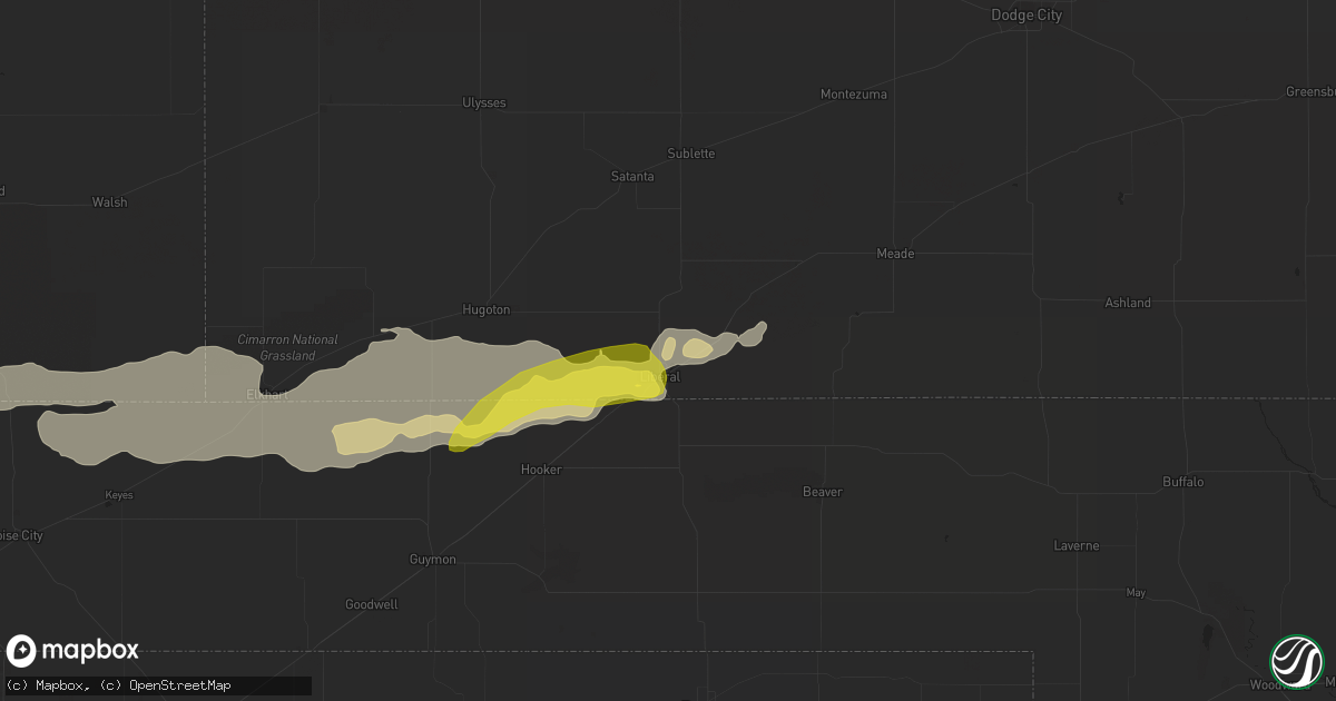
Hail Map in Liberal, KS on June 25, 2021
Get this storm
June 25 map
$229
one time, instant access
Download today. No call, no setup
Keep the $229
Bought the map and want the full workflow? Apply the entire $229 to a subscription within 7 days. None of it is wasted.
Every map, not just this one
This buys you this map. Subscription and you get every map we run, in the markets you choose from a few cities to whole states to nationwide. Plus real-time alerts the moment a storm fires.
Contact data
Name, contact info, occupancy, even credit band for addresses in the footprint. You go from where it hit to who to call.
Become the source they trust
Unlimited branding weather history reports on demand. You already have the documented answer ready for the property owner, and you are the one who showed up with it.
Property data and RoofTrace estimates
Pull up any address you have got, its value and the exact code rules for that jurisdiction, straight from One Click Code. Then RoofTrace estimates the squares, pitch, and roof value, priced the way you price.
Storm reports in Liberal, KS
Liberal, KS
| Date | Description |
|---|---|
| 06/25/20216:45 PM CDT | Quarter size hail... Winds over 60 mph... And power out on social media. |
| 06/25/20216:40 PM CDT | Mesonet station up407 0.6 sw hayne |
| 06/25/20216:36 PM CDT | 3 inch limbs down. |
| 06/25/20216:30 PM CDT | Report of gas lines torn and school roof blown off. |
All States Impacted by Hail Map on June 25, 2021
All Cities Impacted by Hail Map on June 25, 2021
- Follett, TX
- Shattuck, OK
- Cassoday, KS
- El Dorado, KS
- Potwin, KS
- Burns, KS
- Lipscomb, TX
- Canadian, TX
- Higgins, TX
- Dimmitt, TX
- Muleshoe, TX
- Limon, CO
- Agate, CO
- Plainville, KS
- Palco, KS
- Concordia, KS
- Clyde, KS
- Briscoe, TX
- Durham, OK
- Lenorah, TX
- Ackerly, TX
- Gail, TX
- Callaway, NE
- Oconto, NE
- Tipton, KS
- Glen Elder, KS
- Dresden, KS
- Selden, KS
- Jennings, KS
- Upland, NE
- Minden, NE
- Chapman, KS
- Enterprise, KS
- Woodbine, KS
- Junction City, KS
- Hope, KS
- Minneola, KS
- Vega, TX
- Hooker, OK
- Hugo, CO
- Karval, CO
- Clarks, NE
- Marquette, NE
- Central City, NE
- Hordville, NE
- Primrose, NE
- Cedar Rapids, NE
- Curtis, NE
- Saint Francis, KS
- Hazard, NE
- Mason City, NE
- Miller, NE
- Pleasanton, NE
- Amherst, NE
- Sumner, NE
- Panhandle, TX
- Beloit, KS
- Hoxie, KS
- Vici, OK
- Sharon, OK
- Ransom, KS
- Culbertson, NE
- Little River, KS
- Lyons, KS
- Silverton, TX
- Tulia, TX
- Happy, TX
- Hugoton, KS
- Rolla, KS
- Goodwell, OK
- Cope, CO
- Polk, NE
- Wichita, KS
- Benton, KS
- Greenwich, KS
- Valley Center, KS
- St John, KS
- Paola, KS
- Campo, CO
- Hedley, TX
- Clarendon, TX
- Clifton, KS
- Morganville, KS
- Simpson, KS
- Lamesa, TX
- Turpin, OK
- Groom, TX
- Claude, TX
- Saint Paul, NE
- Funk, NE
- Campbell, NE
- Hildreth, NE
- Axtell, NE
- Wilcox, NE
- Imperial, TX
- Kress, TX
- Elbert, CO
- Peyton, CO
- Pritchett, CO
- Amarillo, TX
- Atwood, KS
- Boulder, CO
- Maize, KS
- Lakeview, TX
- Lelia Lake, TX
- Ericson, NE
- Blackwater, MO
- Franklin, MO
- Emporia, KS
- Strong City, KS
- Creston, NE
- Hartford, KS
- Madison, KS
- Olpe, KS
- Murdock, KS
- Cheney, KS
- Ord, NE
- Saint Edward, NE
- Spalding, NE
- Albion, NE
- Bartlett, NE
- Greeley, NE
- Fullerton, NE
- Belgrade, NE
- Burwell, NE
- Scotia, NE
- Mclean, TX
- Wellington, TX
- Shamrock, TX
- Pampa, TX
- Larkspur, CO
- Lafayette, CO
- Louisville, CO
- Pittsfield, IL
- Rhineland, MO
- Hermann, MO
- Warrenton, MO
- Ashland, MO
- Columbia, MO
- Jamestown, MO
- Schuyler, NE
- Buffalo, OK
- Alton, KS
- Hutchinson, KS
- Stockton, KS
- Fargo, OK
- Stafford, KS
- Osborne, KS
- Waldo, KS
- Eureka, KS
- Reydon, OK
- Friona, TX
- Lorenzo, TX
- Post, TX
- Miami, TX
- Newton, KS
- Liberal, KS
- Sylvia, KS
- Dumas, TX
- Sunray, TX
- Shirley, IL
- Haven, KS
- Burrton, KS
- Haviland, KS
- Quail, TX
- Iuka, IL
- Texico, IL
- Bluford, IL
- Pierce, NE
- Ulysses, NE
- Dwight, NE
- Bee, NE
- McCook, NE
- Trenton, NE
- Stratton, NE
- Palisade, NE
- Indianola, NE
- White Deer, TX
- Medford, OK
- Boise City, OK
- Keyes, OK
- Kenton, OK
- Walsh, CO
- Reading, KS
- Hamilton, KS
- Bern, KS
- Du Bois, NE
- Humboldt, NE
- Seneca, KS
- Plevna, KS
- Moundridge, KS
- Plainview, TX
- Memphis, TX
- Loose Creek, MO
- Jefferson City, MO
- Masterson, TX
- Buhler, KS
- Garfield, KS
- Leigh, NE
- Humphrey, NE
- Windsor, MO
- Clinton, MO
- Calhoun, MO
- Kinsley, KS
- Offerle, KS
- Butler, MO
- Crosbyton, TX
- Commerce City, CO
- Brighton, CO
- Fritch, TX
- Matheson, CO
- Ramah, CO
- Gage, OK
- Protection, KS
- Sterling, KS
- Alden, KS
- Macksville, KS
- Overbrook, KS
- Lecompton, KS
- Berryton, KS
- Oakley, KS
- Andover, KS
- Hartsburg, MO
- Marion, KS
- Cedar Point, KS
- Raymond, KS
- Bird City, KS
- Wayside, TX
- Geneseo, KS
- Ralls, TX
- Bradshaw, NE
- Archer, NE
- Benedict, NE
- Stromsburg, NE
- Chapman, NE
- Argonia, KS
- Milton, KS
- Harper, KS
- Danville, KS
- Shawnee, KS
- Lenexa, KS
- Benedict, KS
- Chanute, KS
- Morland, KS
- Neosho Rapids, KS
- La Cygne, KS
- Boonville, MO
- Richfield, KS
- Alpine, TX
- Perryton, TX
- Broken Bow, NE
- Tyrone, OK
- Topeka, KS
- Princeton, KS
- Ottawa, KS
- Wilmore, KS
- Coldwater, KS
- Sun City, KS
- Guymon, OK
- Elkhart, KS
- Berthoud, CO
- Loveland, CO
- Abbyville, KS
- Turon, KS
- Hudson, KS
- Pawnee Rock, KS
- Great Bend, KS
- Albert, KS
- Larned, KS
- Golden, CO
- Quitaque, TX
- Green Valley, IL
- Emden, IL
- Delavan, IL
- San Jose, IL
- Meadow Grove, NE
- Clarkson, NE
- Madison, NE
- Kansas City, MO
- Kansas City, KS
- Iuka, KS
- Arlington, KS
- Colwich, KS
- Gothenburg, NE
- Channing, TX
- Ellinwood, KS
- Walton, KS
- Hesston, KS
- Lyndon, KS
- Scranton, KS
- Osage City, KS
- Johnstown, CO
- McDonald, KS
- Canute, OK
- Elk City, OK
- Ashton, NE
- Rockville, NE
- Farwell, NE
- Loup City, NE
- Litchfield, NE
- Boelus, NE
- Rexford, KS
- Colby, KS
- Beaver, OK
- Saint Libory, NE
- May, OK
- Marquette, KS
- Deerfield, KS
- Holcomb, KS
- Hereford, TX
- Orrick, MO
- Excelsior Springs, MO
- Mobeetie, TX
- Fort Supply, OK
- Wheeler, TX
- Brownell, KS
- Wakeeney, KS
- Greeley, KS
- Osawatomie, KS
- Lane, KS
- Richmond, KS
- Burlington, KS
- Waverly, KS
- Rogers, NE
- Little Cedar, IA
- Osage, IA
- Stacyville, IA
- Pleasant Hill, IL
- Clarksville, MO
- Eolia, MO
- Nebo, IL
- Ness City, KS
- Del Norte, CO
- Center, CO
- Cairo, NE
- Pearl, IL
- Syracuse, KS
- Tecumseh, KS
- Williamsburg, KS
- Kim, CO
- Simla, CO
- Tribune, KS
- Leeton, MO
- Seminole, TX
- Wray, CO
- Red Bud, IL
- La Harpe, KS
- Chilhowee, MO
- Blairstown, MO
- Ansley, NE
- Lewis, KS
- Isabel, KS
- Nashville, KS
- Dill City, OK
- Foss, OK
- Lebo, KS
- Downs, KS
- Osmond, NE
- Wright City, MO
- Troy, MO
- Truesdale, MO
- Marthasville, MO
- Grenville, NM
- Adrian, MO
- Drexel, MO
- Pratt, KS
- Peabody, KS
- Halstead, KS
- Wolbach, NE
- Ford, KS
- Dodge City, KS
- Tahoka, TX
- Wilson, TX
- Ravenna, NE
- Heyworth, IL
- Wapella, IL
- Medicine Lodge, KS
- Natoma, KS
- Nederland, CO
- Rush, CO
- Mcpherson, KS
- Inman, KS
- Alva, OK
- Atlanta, IL
- McLean, IL
- Manito, IL
- Mason City, IL
- Forest City, IL
- Armington, IL
- Lincoln, IL
- Hartsburg, IL
- Jamestown, KS
- Glasco, KS
- Conway Springs, KS
- Centertown, MO
- Lohman, MO
- Crawford, OK
- Spearville, KS
- Lockney, TX
- Lindsborg, KS
- Lake City, KS
- Fowler, KS
- Creighton, MO
- Windom, KS
- Luray, KS
- Woodston, KS
- Cheyenne, OK
- Grand Island, NE
- Elba, NE
- Sentinel, OK
- Bloomington, IL
- Partridge, KS
- Nickerson, KS
- Independence, MO
- Baileyville, KS
- Fort Morgan, CO
- Beeler, KS
- Festus, MO
- Walsenburg, CO
- Levelland, TX
- Cottonwood Falls, KS
- Bentley, KS
- Sedgwick, KS
- Goessel, KS
- Kechi, KS
- Florence, KS
- Towanda, KS
- Augusta, KS
- Rosalia, KS
- Americus, KS
- Mount Hope, KS
- Elbing, KS
- Hillsboro, KS
- Mcconnell Afb, KS
- South Hutchinson, KS
- Whitewater, KS
- Derby, KS
- Canton, KS
- Elmdale, KS
- Matfield Green, KS
- Andale, KS
- North Newton, KS
- Arnett, OK
- Tilden, NE
- Quenemo, KS
- Welda, KS
- Zenda, KS
- Erie, KS
- Virgil, KS
- Meade, KS
- Danbury, NE
- Iola, KS
- Spivey, KS
- Ellis, KS
- Hays, KS
- Eddyville, NE
- Lexington, NE
- Skellytown, TX
- Stratton, CO
- Vona, CO
- Garnett, KS
- Louisburg, KS
- Pomona, KS
- Melvern, KS
- New Bloomfield, MO
- Palmer, NE
- Farwell, TX
- Morton, TX
- Littlefield, TX
- Belpre, KS
- Texico, NM
- Pleasanton, KS
- Mound City, KS
- Westphalia, KS
- Prairie Du Rocher, IL
- Fults, IL
- Urich, MO
- Council Grove, KS
- Allen, KS
- Alma, KS
- Rantoul, KS
- Parker, KS
- Fontana, KS
- Grantville, KS
- Meriden, KS
- Oskaloosa, KS
- Ozawkie, KS
- Viola, KS
- Pretty Prairie, KS
- Attica, KS
- Goddard, KS
- Garden Plain, KS
- Norwich, KS
- Kingman, KS
- Galva, KS
- Wright, KS
- Jetmore, KS
- Ensign, KS
- Hanston, KS
- Atlanta, KS
- Douglass, KS
- Borger, TX
- Stanton, TX
- Clinton, OK
- Sweetwater, OK
- Seiling, OK
- Fay, OK
- Custer City, OK
- Putnam, OK
- Hammon, OK
- Oakwood, OK
- Sayre, OK
- Taloga, OK
- Watonga, OK
- Leedey, OK
- Canton, OK
- Arapaho, OK
- Butler, OK
- Thomas, OK
- Erick, OK
- Texola, OK
- Willow, OK
- Bessie, OK
- Corn, OK
- Edmond, OK
- Bethany, OK
- Piedmont, OK
- El Reno, OK
- Jones, OK
- Kingfisher, OK
- Calumet, OK
- Oklahoma City, OK
- Yukon, OK
- Okarche, OK
- Delphi, IN
- Lafayette, IN
- Rossville, IN
- Flora, IN
- Bringhurst, IN
- Holdrege, NE
- Dawson, NE
- Cactus, TX
- Lawndale, IL
- Beason, IL
- Downs, IL
- Winchester, IL
- Hillview, IL
- Chapin, IL
- Meredosia, IL
- Ashland, IL
- Concord, IL
- New Berlin, IL
- Alexander, IL
- Pleasant Plains, IL
- Petersburg, IL
- Jacksonville, IL
- Bluffs, IL
- Tallula, IL
- Danforth, IL
- Gilman, IL


