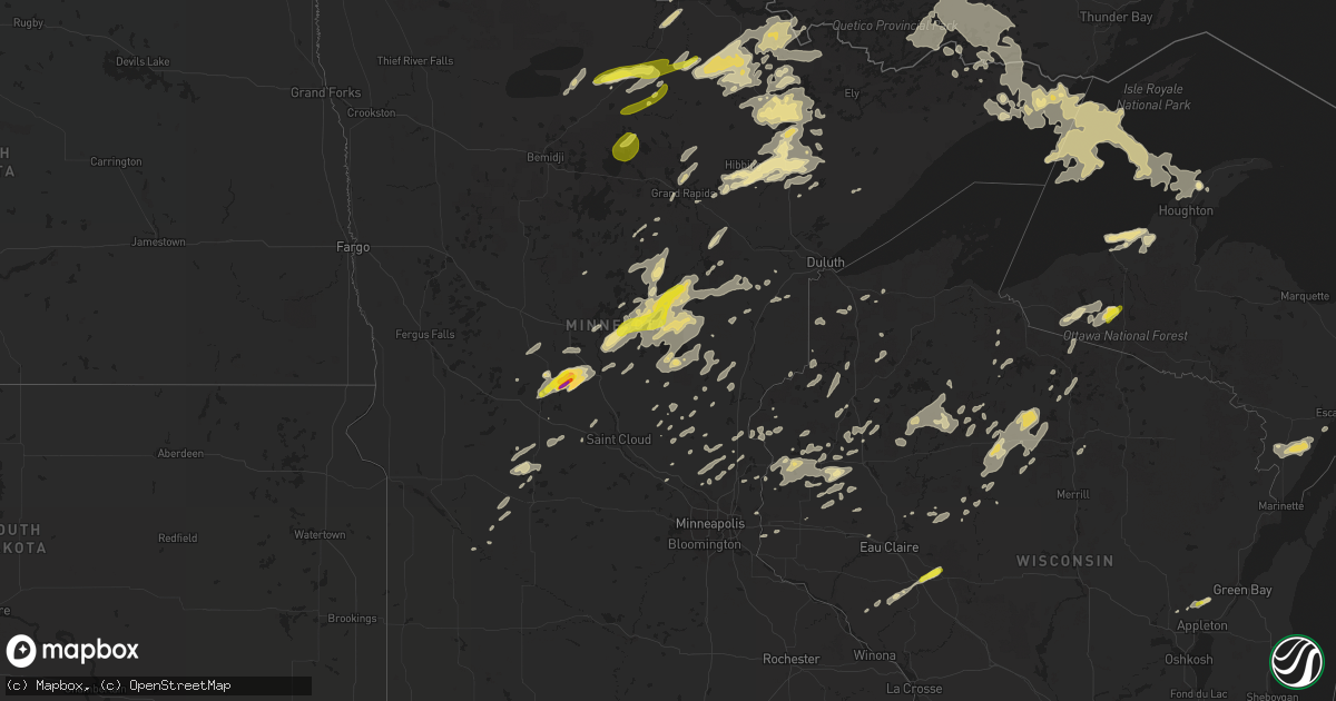
Hail Map in Minnesota on June 25, 2016
Get this storm
June 25 map
$229
one time, instant access
Download today. No call, no setup
Keep the $229
Bought the map and want the full workflow? Apply the entire $229 to a subscription within 7 days. None of it is wasted.
Every map, not just this one
This buys you this map. Subscription and you get every map we run, in the markets you choose from a few cities to whole states to nationwide. Plus real-time alerts the moment a storm fires.
Contact data
Name, contact info, occupancy, even credit band for addresses in the footprint. You go from where it hit to who to call.
Become the source they trust
Unlimited branding weather history reports on demand. You already have the documented answer ready for the property owner, and you are the one who showed up with it.
Property data and RoofTrace estimates
Pull up any address you have got, its value and the exact code rules for that jurisdiction, straight from One Click Code. Then RoofTrace estimates the squares, pitch, and roof value, priced the way you price.
Storm reports in Minnesota
Minnesota
| Date | Description |
|---|---|
| 06/25/20166:45 PM CDT | Three large trees snapped off about 15 feet off the ground. Occurred near jefferson and 125th ave. |
| 06/25/20166:05 PM CDT | Power out across portion of city. Numerous trees down across the city. |
| 06/25/20166:05 PM CDT | Scattered trees and power lines toppled. Additional scattered trees and power lines down across northern half of county. . |
| 06/25/20166:05 PM CDT | Many trees down across city. |
| 06/25/20166:05 PM CDT | Late report...a 12 inch diameter tree toppled 12-13 feet above the ground. |
| 06/25/20166:00 PM CDT | Falcon drive at 425th st. Was blocked by a couple of downed trees. |
| 06/25/20165:40 PM CDT | Picture of a large tree down in elk river received via social media. |
| 06/25/20165:33 PM CDT | Several trees broken 8 feet below tops. Numerous branches broken across area. |
| 06/25/20165:27 PM CDT | Several 6-12 inch aspen and 12 inch balsam uprooted. |
| 06/25/20165:10 PM CDT | Photos received of a few trees downed. Time estimated by radar. |
| 06/25/20165:08 PM CDT | Mesonet station 3 sw orr /orbm5/. |
| 06/25/20165:03 PM CDT | Two 8-10 inch diameter birch trees snapped off at the base. Time estimated by radar. |
| 06/25/20164:50 PM CDT | A few trees down. |
| 06/25/20164:27 PM CDT | Three 12-inch diameter maple trees snapped approx 16 inches up from the base. Relayed by duluth media. |
| 06/25/20164:20 PM CDT | Several 6 to 12 inch diameter trees broken... Numerous 3 to 5 diameter branches littering road. Road partially blocked. |
| 06/25/20164:16 PM CDT | 10 inch diameter tree broken. Several other dead trees toppled in back acreage. Occurred between 4 and 5 pm. Time estimated from radar. |
| 06/25/20163:55 PM CDT | Tree toppled across road. |
| 06/25/20163:45 PM CDT | A few 10 inch diameter trees downed. Time estimated by radar. |
| 06/25/20163:41 PM CDT | . |
| 06/25/20163:34 PM CDT | Lots of trees down. Had some 2 to 3 foot diameter trees uprooted. Along with several 3 to 4 inch diameter trees snapped. Time estimated by radar. |
| 06/25/20163:15 PM CDT | . |
| 06/25/20163:04 PM CDT | Several large trees downed. Time estimated by radar. |
| 06/25/201612:17 AM CDT | Several trees were blown down |
All States Impacted by Hail Map on June 25, 2016
Cities Impacted by Hail Map on June 25, 2016
- Osborne, KS
- Downs, KS
- Gaylesville, AL
- Bedford, IA
- Blockton, IA
- Hawkins, WI
- Keyes, OK
- Saint Croix Falls, WI
- Centuria, WI
- Littlefork, MN
- Orr, MN
- Dighton, KS
- Utica, KS
- Healy, KS
- Beeler, KS
- Garden City, KS
- Big Falls, MN
- Sugar City, CO
- Huntsville, AL
- Marienthal, KS
- Leoti, KS
- Deerfield, KS
- Lakin, KS
- Stephenson, MI
- Daggett, MI
- Balmorhea, TX
- Fayetteville, TN
- Cook, MN
- Tower, MN
- Angora, MN
- Gleason, TN
- McKenzie, TN
- Aitkin, MN
- Granite Falls, MN
- Hibbing, MN
- Seneca, KS
- Axtell, KS
- Baileyville, KS
- Beattie, KS
- Home, KS
- Summerfield, KS
- Brownsboro, AL
- Meridianville, AL
- New Market, AL
- Strum, WI
- Independence, WI
- Grantsburg, WI
- Hazel, KY
- Randall, MN
- Flensburg, MN
- Swanville, MN
- Long Prairie, MN
- Burtrum, MN
- Grey Eagle, MN
- Little Falls, MN
- Carlsbad, NM
- Colfax, WI
- Wheeler, WI
- Hohenwald, TN
- Waynesboro, TN
- Lawrenceburg, TN
- Calumet, MI
- Allouez, MI
- Goodwell, OK
- Texhoma, OK
- Park Falls, WI
- Phillips, WI
- Glasco, KS
- Grand Rivers, KY
- Smithland, KY
- Tiline, KY
- Salem, KY
- Oak Park, MN
- Foley, MN
- Foreston, MN
- Sturgeon Lake, MN
- Lindstrom, MN
- Scandia, MN
- Virginia, MN
- Gilbert, MN
- Iron, MN
- Mountain Iron, MN
- Eveleth, MN
- Columbia, TN
- Sedalia, CO
- Ely, MN
- Wakeeney, KS
- Ransom, KS
- Anniston, AL
- Olney Springs, CO
- Ordway, CO
- Hays, KS
- Rocksprings, TX
- Woodville, WI
- Alma, WI
- Black Creek, WI
- Hortonville, WI
- Seymour, WI
- Appleton, WI
- Shiocton, WI
- Mosquero, NM
- Foxboro, WI
- Paris, TN
- Dresden, TN
- Palmersville, TN
- Presque Isle, WI
- Boulder Junction, WI
- Cordele, GA
- Pitts, GA
- Pecos, TX
- Grand Marais, MN
- Osseo, WI
- Fairchild, WI
- Augusta, WI
- Spring Hill, TN
- Aurora, MN
- Farmington, KY
- Heflin, AL
- Ranburne, AL
- Muscadine, AL
- Pleasant Hill, IL
- Andover, MN
- Winter, WI
- Fort Ripley, MN
- Brainerd, MN
- Murray, KY
- Osakis, MN
- Hudson, WI
- Houlton, WI
- Stillwater, MN
- Bayport, MN
- Waldo, KS
- Gurley, AL
- Fort Stockton, TX
- Dawson, GA
- Shellman, GA
- Monticello, MN
- Larkspur, CO
- Franktown, CO
- Castle Rock, CO
- Johnsonville, SC
- Lewisburg, TN
- Belfast, TN
- Onamia, MN
- Palisade, MN
- Santa Fe, TN
- Franklin, TN
- Hugoton, KS
- Ulysses, KS
- Melrose, MN
- Belgrade, MN
- Paynesville, MN
- Freeport, MN
- Crane Lake, MN
- Butternut, WI
- Victoria, KS
- Lucas, KS
- Walker, KS
- Russell, KS
- Gorham, KS
- Luray, KS
- Bunker Hill, KS
- Ellis, KS
- Paradise, KS
- Nodaway, IA
- Corning, IA
- Thompson, IA
- Scarville, IA
- Bruce Crossing, MI
- Ewen, MI
- Marenisco, MI
- South Range, WI
- Solon Springs, WI
- Remer, MN
- Lynchburg, SC
- Olanta, SC
- Richland, GA
- Buena Vista, GA
- Cusseta, GA
- New London, MN
- Cimarron, KS
- Brock, NE
- Colorado Springs, CO
- Brule, WI
- Iron River, WI
- Lac Du Flambeau, WI
- Minocqua, WI
- Comstock, TX
- Cushing, MN
- Ontonagon, MI
- Kelliher, MN
- Spicer, MN
- Pennock, MN
- Willmar, MN
- Preston, GA
- Clayton, WI
- Barron, WI
- Turtle Lake, WI
- Almena, WI
- Prairie Farm, WI
- Box Springs, GA
- Greene, IA
- Watertown, WI
- Johnson, KS
- Richfield, KS
- Rolla, KS
- Catawba, WI
- Ogema, WI
- Prentice, WI
- Jacobson, MN
- Dryden, TX
- Eastaboga, AL
- Munford, AL
- Cushing, WI
- Quinter, KS
- Gove, KS
- Pierz, MN
- Brimson, MN
- Hamburg, IA
- Owens Cross Roads, AL
- Stanberry, MO
- Guilford, MO
- Britt, MN
- Sauk Centre, MN
- Plains, GA
- Oakdale, IL
- Coulterville, IL
- Westboro, MO
- Cambridge, MN
- North Branch, MN
- Pamplico, SC
- Grand Portage, MN
- Blanchard, IA
- Coin, IA
- Clarinda, IA
- Table Rock, NE
- Raymond, MN
- Frohna, MO
- Mcgregor, MN
- Wahkon, MN
- Tamarack, MN
- Wright, MN
- Kettle River, MN
- Crosslake, MN
- Isle, MN
- McGrath, MN
- Ironton, MN
- Cromwell, MN
- Crosby, MN
- Hillman, MN
- Deerwood, MN
- Swatara, MN
- Emily, MN
- Garrison, MN
- Fifty Lakes, MN
- Americus, GA
- Cordesville, SC
- Bonneau, SC
- Calvert City, KY
- Gilbertsville, KY
- Benton, KY
- Talbotton, GA
- Fort Benning, GA
- Arlington, CO
- Lake Nebagamon, WI
- Poplar, WI
- Danbury, WI
- Haugen, WI
- Birchwood, WI
- Sarona, WI
- Rice Lake, WI
- Makinen, MN
- Bloomfield, NE
- Milaca, MN
- Cumberland, WI
- Leesburg, GA
- Swaledale, IA
- Balsam Lake, WI
- Amery, WI
- Dresser, WI
- Embarrass, MN
- Pengilly, MN
- Hoyt Lakes, MN
- Smithville, GA
- Isanti, MN
- Hazel Green, AL
- Wyoming, MN
- River Falls, WI
- Clear Lake, WI
- Glenwood City, WI
- Downing, WI
- Marysville, KS
- Perryville, MO
- Stacy, MN
- Brownville, NE
- Peru, NE
- Watson, MO
- Tomahawk, WI
- Blackduck, MN
- Sacramento, NM
- Weed, NM
- Mayhill, NM
- Uvalde, TX
- Villisca, IA
- Stanton, IA
- Conchas Dam, NM
- Union Grove, AL
- Middleton, WI
- Waunakee, WI
- Bovey, MN
- Grand Rapids, MN
- Hovland, MN
- Ladysmith, WI
- Bruce, WI
- Radisson, WI
- Glen Flora, WI
- Exeland, WI
- Ojibwa, WI
- Andrews, SC
- Petersburg, TN
- Clara City, MN
- Maynard, MN
- Guymon, OK
- Gordon, WI
- Arabi, GA
- Ashburn, GA
- Roswell, NM
- Bigfork, MN
- Brantwood, WI
- Barnard, MO
- Boyd, WI
- Cadott, WI
- Cornell, WI
- Elmo, MO
- Tarkio, MO
- Burlington Junction, MO
- Ogallah, KS
- Arcadia, FL
- Ludowici, GA
- Westboro, WI
- Medford, WI
- Tripoli, WI
- Sidney, IA
- Princeton, MN
- Dongola, IL
- Anna, IL
- Shell Lake, WI
- Spooner, WI
- Brooten, MN
- Sunburg, MN
- Moose Lake, MN
- Pillager, MN
- Johnson, NE
- Bushnell, FL
- Mora, MN
- Grasston, MN
- Braham, MN
- Ravenwood, MO
- Maryville, MO
- Red Oak, IA
- Essex, IA
- Mizpah, MN
- Sedalia, KY
- Bertha, MN
- Eagle Bend, MN
- Clarissa, MN
- Dallas, WI
- Hanover, KS
- Bremen, KS
- Satanta, KS
- Dalhart, TX
- Sabinal, TX
- Campbellsport, WI
- Boyceville, WI
- Ridgeland, WI
- Marion, SC
- Barnum, MN
- Bartow, FL
- Springfield, CO
- Thorp, WI
- Bark River, MI
- Iron Belt, WI
- Kerkhoven, MN
- Jetmore, KS
- Flintville, TN
- Avon, SD
- Cloquet, MN
- Van Horn, TX
- Pine River, MN
- Brunswick, NE
- Thurman, IA
- Riverton, IA
- Nebraska City, NE
- Percival, IA
- Goodland, MN
- Du Bois, NE
- Mondovi, WI
- Elk River, MN
- Somerville, AL
- Grant, AL
- Laceys Spring, AL
- Paint Rock, AL
- Oketo, KS
- Wymore, NE
- Hayden, AL
- Brookport, IL
- Ledbetter, KY
- Hayward, WI
- Minong, WI
- Forbes, MN
- Washington Island, WI
- Garden, MI
- Simpson, KS
- Beloit, KS
- Spring Lake, MN
- Max, MN
- New Richmond, WI
- Martinsville, MO
- Boise City, OK
- Rock Port, MO
- Collinwood, TN
- Dalbo, MN
- Timmonsville, SC
- Creighton, NE
- Osceola, WI
- Avon, MN
- Trego, WI
- Webster, WI
- Brackettville, TX
- Del Rio, TX
- Clear Lake, IA
- Thornton, IA
- Holdingford, MN
- Saint Joseph, MN
- Jim Falls, WI
- Cottage Grove, TN
- Weston, GA
- Burchard, NE
- Pawnee City, NE
- Boone, CO
- Spring Grove, MN
- Hancock, MI
- Houghton, MI
- Ahmeek, MI
- Atlantic Mine, MI
- Copper City, MI
- Ness City, KS
- Elkhart, KS
- Wakefield, MI
- Garner, IA
- Brook Park, MN
- Pine City, MN
- Britt, IA
- Irma, WI
- Hinckley, MN
- Brooksville, FL
- Huger, SC
- Glen Elder, KS
- Fort Myers, FL
- Odessa, FL
- Wayne City, IL
- Fairfield, IL
- Steinauer, NE
- Gilman, WI
- Wilson, MI
- Carney, MI
- Baldwin, WI
- Bristow, IA
- Mescalero, NM
- Scott City, KS
- Collyer, KS
- Arnold, KS
- Merrifield, MN
- Farragut, IA
- Shenandoah, IA
- Frederic, WI
- Hastings, NE
- Ogilvie, MN
- Batesville, TX
- Comstock, WI
- Hiawatha, KS
- Morrill, KS
- Sacred Heart, MN
- Luck, WI
- Punta Gorda, FL
- Fairfax, MO
- Conception Junction, MO
- Roberts, WI
- Zimmerman, MN
- Tecumseh, NE
- Lake Mills, IA
- Stanley, WI
- Burna, KY
- Biwabik, MN
- Kinney, MN
- Buhl, MN
- Chisholm, MN
- Frankfort, KS
- Star Prairie, WI
- Worthing, SD
- Canton, SD
- Mound City, MO
- Maitland, MO
- Nesmith, SC
- Kingstree, SC
- Northome, MN
- Babbitt, MN
- Cornersville, TN
- Withee, WI
- Rib Lake, WI
- Dunbar, NE
- Barronett, WI
- Cohasset, MN
- Woodruff, WI
- Calhan, CO
- Lublin, WI
- Hockley, TX
- Charleston, MO
- Bethel, MN
- Cedar, MN
- Saint Francis, MN
- Anoka, MN
- Forest Lake, MN
- Sandstone, MN
- Harris, MN
- Eleva, WI
- Wichita, KS
- Elk Mound, WI
- Milltown, WI
- Cotton, MN
- Chippewa Falls, WI
- Prescott, IA
- Stone Lake, WI
- Dodge City, KS
- International Falls, MN
- New Concord, KY
- Auburn, NE
- Lake Linden, MI
- Talmage, NE
- Cook, NE
- Lake Mills, WI
- Graham, MO
- Skidmore, MO
- Squaw Lake, MN
- Deer River, MN
- Wirt, MN
- Effie, MN
- Cody, NE
- Whitman, NE
- Merriman, NE
- Dunseith, ND
- Saint John, ND
- Mandaree, ND
- Watford City, ND
- Ryder, ND
- Makoti, ND
- Killdeer, ND
- Plaza, ND
- Parshall, ND
- New Town, ND
- Keene, ND
- Roseglen, ND
- Williston, ND
- Zahl, ND
- Grenora, ND
- Taylor, ND
- Dickinson, ND
- Gladstone, ND
- Richardton, ND


