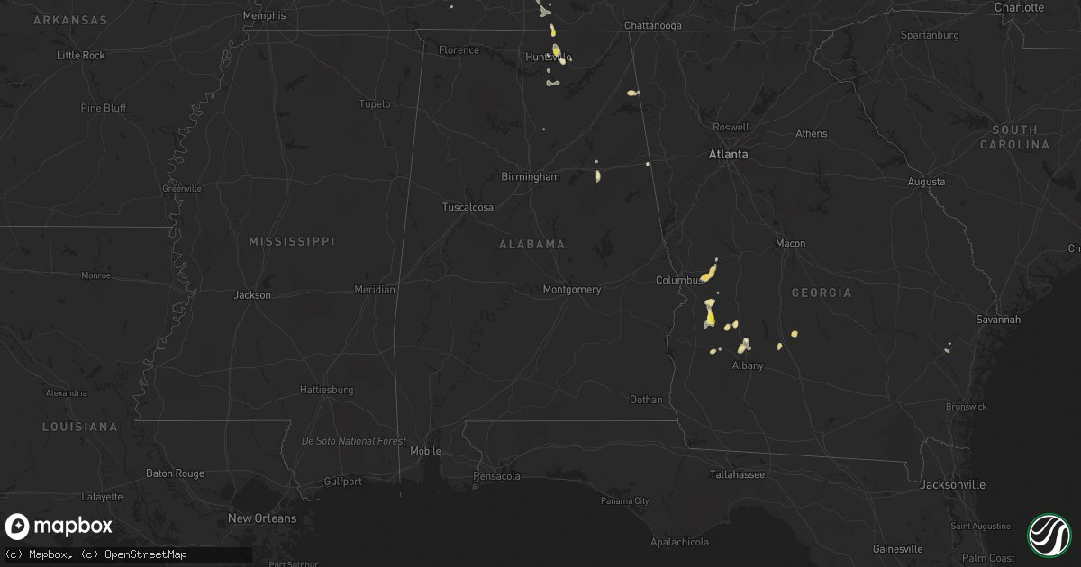
Hail Map in Alabama on June 25, 2016
Get this storm
June 25 map
$229
one time, instant access
Download today. No call, no setup
Keep the $229
Bought the map and want the full workflow? Apply the entire $229 to a subscription within 7 days. None of it is wasted.
Every map, not just this one
This buys you this map. Subscription and you get every map we run, in the markets you choose from a few cities to whole states to nationwide. Plus real-time alerts the moment a storm fires.
Contact data
Name, contact info, occupancy, even credit band for addresses in the footprint. You go from where it hit to who to call.
Become the source they trust
Unlimited branding weather history reports on demand. You already have the documented answer ready for the property owner, and you are the one who showed up with it.
Property data and RoofTrace estimates
Pull up any address you have got, its value and the exact code rules for that jurisdiction, straight from One Click Code. Then RoofTrace estimates the squares, pitch, and roof value, priced the way you price.
Storm reports in Alabama
Alabama
| Date | Description |
|---|---|
| 06/25/20166:15 PM CDT | A power line was reported down on brownsboro road and highway 72. Fire department responding. |
| 06/25/20166:12 PM CDT | Nickel to quarter size hail was reported on sugar plum road beginning to accumulate on the ground. |
| 06/25/20166:12 PM CDT | Nickel to quarter size hail was reported on sugar plum road beginning to accumulate on the ground. |
| 06/25/20166:09 PM CDT | Half dollar size hail was reported in the mount carmel area. |
| 06/25/20166:08 PM CDT | A tree was reported down on oak park drive near bankhead parkway ne. |
| 06/25/20166:05 PM CDT | Quarter size hail was reported. |
| 06/25/20166:05 PM CDT | Half dollar size hail was reported in the riverton area of moore mill off of winchester road. |
| 06/25/20165:52 PM CDT | A 30 foot by 40 foot section of metal roofing was blown onto the road at the intersection of miller road and gray road in the gurley community. |
| 06/25/20165:50 PM CDT | Tree reported down by sherrif office in gurley. |
| 06/25/20165:08 PM CDT | One large tree down into a roadway in munford. |
| 06/25/20166:10 AM CDT | A tree was downed onto a home due to thunderstorm winds. |
| 06/24/20168:25 PM CDT | Another wind gust has affected the broomtown area and numerous trees have been knocked down. |
| 06/24/20168:05 PM CDT | A few trees were blown down in separate locations around broomtown. Winds estimated at 50 mph. |
All States Impacted by Hail Map on June 25, 2016
Cities Impacted by Hail Map on June 25, 2016
- Osborne, KS
- Downs, KS
- Gaylesville, AL
- Bedford, IA
- Blockton, IA
- Hawkins, WI
- Keyes, OK
- Saint Croix Falls, WI
- Centuria, WI
- Littlefork, MN
- Orr, MN
- Dighton, KS
- Utica, KS
- Healy, KS
- Beeler, KS
- Garden City, KS
- Big Falls, MN
- Sugar City, CO
- Huntsville, AL
- Marienthal, KS
- Leoti, KS
- Deerfield, KS
- Lakin, KS
- Stephenson, MI
- Daggett, MI
- Balmorhea, TX
- Fayetteville, TN
- Cook, MN
- Tower, MN
- Angora, MN
- Gleason, TN
- McKenzie, TN
- Aitkin, MN
- Granite Falls, MN
- Hibbing, MN
- Seneca, KS
- Axtell, KS
- Baileyville, KS
- Beattie, KS
- Home, KS
- Summerfield, KS
- Brownsboro, AL
- Meridianville, AL
- New Market, AL
- Strum, WI
- Independence, WI
- Grantsburg, WI
- Hazel, KY
- Randall, MN
- Flensburg, MN
- Swanville, MN
- Long Prairie, MN
- Burtrum, MN
- Grey Eagle, MN
- Little Falls, MN
- Carlsbad, NM
- Colfax, WI
- Wheeler, WI
- Hohenwald, TN
- Waynesboro, TN
- Lawrenceburg, TN
- Calumet, MI
- Allouez, MI
- Goodwell, OK
- Texhoma, OK
- Park Falls, WI
- Phillips, WI
- Glasco, KS
- Grand Rivers, KY
- Smithland, KY
- Tiline, KY
- Salem, KY
- Oak Park, MN
- Foley, MN
- Foreston, MN
- Sturgeon Lake, MN
- Lindstrom, MN
- Scandia, MN
- Virginia, MN
- Gilbert, MN
- Iron, MN
- Mountain Iron, MN
- Eveleth, MN
- Columbia, TN
- Sedalia, CO
- Ely, MN
- Wakeeney, KS
- Ransom, KS
- Anniston, AL
- Olney Springs, CO
- Ordway, CO
- Hays, KS
- Rocksprings, TX
- Woodville, WI
- Alma, WI
- Black Creek, WI
- Hortonville, WI
- Seymour, WI
- Appleton, WI
- Shiocton, WI
- Mosquero, NM
- Foxboro, WI
- Paris, TN
- Dresden, TN
- Palmersville, TN
- Presque Isle, WI
- Boulder Junction, WI
- Cordele, GA
- Pitts, GA
- Pecos, TX
- Grand Marais, MN
- Osseo, WI
- Fairchild, WI
- Augusta, WI
- Spring Hill, TN
- Aurora, MN
- Farmington, KY
- Heflin, AL
- Ranburne, AL
- Muscadine, AL
- Pleasant Hill, IL
- Andover, MN
- Winter, WI
- Fort Ripley, MN
- Brainerd, MN
- Murray, KY
- Osakis, MN
- Hudson, WI
- Houlton, WI
- Stillwater, MN
- Bayport, MN
- Waldo, KS
- Gurley, AL
- Fort Stockton, TX
- Dawson, GA
- Shellman, GA
- Monticello, MN
- Larkspur, CO
- Franktown, CO
- Castle Rock, CO
- Johnsonville, SC
- Lewisburg, TN
- Belfast, TN
- Onamia, MN
- Palisade, MN
- Santa Fe, TN
- Franklin, TN
- Hugoton, KS
- Ulysses, KS
- Melrose, MN
- Belgrade, MN
- Paynesville, MN
- Freeport, MN
- Crane Lake, MN
- Butternut, WI
- Victoria, KS
- Lucas, KS
- Walker, KS
- Russell, KS
- Gorham, KS
- Luray, KS
- Bunker Hill, KS
- Ellis, KS
- Paradise, KS
- Nodaway, IA
- Corning, IA
- Thompson, IA
- Scarville, IA
- Bruce Crossing, MI
- Ewen, MI
- Marenisco, MI
- South Range, WI
- Solon Springs, WI
- Remer, MN
- Lynchburg, SC
- Olanta, SC
- Richland, GA
- Buena Vista, GA
- Cusseta, GA
- New London, MN
- Cimarron, KS
- Brock, NE
- Colorado Springs, CO
- Brule, WI
- Iron River, WI
- Lac Du Flambeau, WI
- Minocqua, WI
- Comstock, TX
- Cushing, MN
- Ontonagon, MI
- Kelliher, MN
- Spicer, MN
- Pennock, MN
- Willmar, MN
- Preston, GA
- Clayton, WI
- Barron, WI
- Turtle Lake, WI
- Almena, WI
- Prairie Farm, WI
- Box Springs, GA
- Greene, IA
- Watertown, WI
- Johnson, KS
- Richfield, KS
- Rolla, KS
- Catawba, WI
- Ogema, WI
- Prentice, WI
- Jacobson, MN
- Dryden, TX
- Eastaboga, AL
- Munford, AL
- Cushing, WI
- Quinter, KS
- Gove, KS
- Pierz, MN
- Brimson, MN
- Hamburg, IA
- Owens Cross Roads, AL
- Stanberry, MO
- Guilford, MO
- Britt, MN
- Sauk Centre, MN
- Plains, GA
- Oakdale, IL
- Coulterville, IL
- Westboro, MO
- Cambridge, MN
- North Branch, MN
- Pamplico, SC
- Grand Portage, MN
- Blanchard, IA
- Coin, IA
- Clarinda, IA
- Table Rock, NE
- Raymond, MN
- Frohna, MO
- Mcgregor, MN
- Wahkon, MN
- Tamarack, MN
- Wright, MN
- Kettle River, MN
- Crosslake, MN
- Isle, MN
- McGrath, MN
- Ironton, MN
- Cromwell, MN
- Crosby, MN
- Hillman, MN
- Deerwood, MN
- Swatara, MN
- Emily, MN
- Garrison, MN
- Fifty Lakes, MN
- Americus, GA
- Cordesville, SC
- Bonneau, SC
- Calvert City, KY
- Gilbertsville, KY
- Benton, KY
- Talbotton, GA
- Fort Benning, GA
- Arlington, CO
- Lake Nebagamon, WI
- Poplar, WI
- Danbury, WI
- Haugen, WI
- Birchwood, WI
- Sarona, WI
- Rice Lake, WI
- Makinen, MN
- Bloomfield, NE
- Milaca, MN
- Cumberland, WI
- Leesburg, GA
- Swaledale, IA
- Balsam Lake, WI
- Amery, WI
- Dresser, WI
- Embarrass, MN
- Pengilly, MN
- Hoyt Lakes, MN
- Smithville, GA
- Isanti, MN
- Hazel Green, AL
- Wyoming, MN
- River Falls, WI
- Clear Lake, WI
- Glenwood City, WI
- Downing, WI
- Marysville, KS
- Perryville, MO
- Stacy, MN
- Brownville, NE
- Peru, NE
- Watson, MO
- Tomahawk, WI
- Blackduck, MN
- Sacramento, NM
- Weed, NM
- Mayhill, NM
- Uvalde, TX
- Villisca, IA
- Stanton, IA
- Conchas Dam, NM
- Union Grove, AL
- Middleton, WI
- Waunakee, WI
- Bovey, MN
- Grand Rapids, MN
- Hovland, MN
- Ladysmith, WI
- Bruce, WI
- Radisson, WI
- Glen Flora, WI
- Exeland, WI
- Ojibwa, WI
- Andrews, SC
- Petersburg, TN
- Clara City, MN
- Maynard, MN
- Guymon, OK
- Gordon, WI
- Arabi, GA
- Ashburn, GA
- Roswell, NM
- Bigfork, MN
- Brantwood, WI
- Barnard, MO
- Boyd, WI
- Cadott, WI
- Cornell, WI
- Elmo, MO
- Tarkio, MO
- Burlington Junction, MO
- Ogallah, KS
- Arcadia, FL
- Ludowici, GA
- Westboro, WI
- Medford, WI
- Tripoli, WI
- Sidney, IA
- Princeton, MN
- Dongola, IL
- Anna, IL
- Shell Lake, WI
- Spooner, WI
- Brooten, MN
- Sunburg, MN
- Moose Lake, MN
- Pillager, MN
- Johnson, NE
- Bushnell, FL
- Mora, MN
- Grasston, MN
- Braham, MN
- Ravenwood, MO
- Maryville, MO
- Red Oak, IA
- Essex, IA
- Mizpah, MN
- Sedalia, KY
- Bertha, MN
- Eagle Bend, MN
- Clarissa, MN
- Dallas, WI
- Hanover, KS
- Bremen, KS
- Satanta, KS
- Dalhart, TX
- Sabinal, TX
- Campbellsport, WI
- Boyceville, WI
- Ridgeland, WI
- Marion, SC
- Barnum, MN
- Bartow, FL
- Springfield, CO
- Thorp, WI
- Bark River, MI
- Iron Belt, WI
- Kerkhoven, MN
- Jetmore, KS
- Flintville, TN
- Avon, SD
- Cloquet, MN
- Van Horn, TX
- Pine River, MN
- Brunswick, NE
- Thurman, IA
- Riverton, IA
- Nebraska City, NE
- Percival, IA
- Goodland, MN
- Du Bois, NE
- Mondovi, WI
- Elk River, MN
- Somerville, AL
- Grant, AL
- Laceys Spring, AL
- Paint Rock, AL
- Oketo, KS
- Wymore, NE
- Hayden, AL
- Brookport, IL
- Ledbetter, KY
- Hayward, WI
- Minong, WI
- Forbes, MN
- Washington Island, WI
- Garden, MI
- Simpson, KS
- Beloit, KS
- Spring Lake, MN
- Max, MN
- New Richmond, WI
- Martinsville, MO
- Boise City, OK
- Rock Port, MO
- Collinwood, TN
- Dalbo, MN
- Timmonsville, SC
- Creighton, NE
- Osceola, WI
- Avon, MN
- Trego, WI
- Webster, WI
- Brackettville, TX
- Del Rio, TX
- Clear Lake, IA
- Thornton, IA
- Holdingford, MN
- Saint Joseph, MN
- Jim Falls, WI
- Cottage Grove, TN
- Weston, GA
- Burchard, NE
- Pawnee City, NE
- Boone, CO
- Spring Grove, MN
- Hancock, MI
- Houghton, MI
- Ahmeek, MI
- Atlantic Mine, MI
- Copper City, MI
- Ness City, KS
- Elkhart, KS
- Wakefield, MI
- Garner, IA
- Brook Park, MN
- Pine City, MN
- Britt, IA
- Irma, WI
- Hinckley, MN
- Brooksville, FL
- Huger, SC
- Glen Elder, KS
- Fort Myers, FL
- Odessa, FL
- Wayne City, IL
- Fairfield, IL
- Steinauer, NE
- Gilman, WI
- Wilson, MI
- Carney, MI
- Baldwin, WI
- Bristow, IA
- Mescalero, NM
- Scott City, KS
- Collyer, KS
- Arnold, KS
- Merrifield, MN
- Farragut, IA
- Shenandoah, IA
- Frederic, WI
- Hastings, NE
- Ogilvie, MN
- Batesville, TX
- Comstock, WI
- Hiawatha, KS
- Morrill, KS
- Sacred Heart, MN
- Luck, WI
- Punta Gorda, FL
- Fairfax, MO
- Conception Junction, MO
- Roberts, WI
- Zimmerman, MN
- Tecumseh, NE
- Lake Mills, IA
- Stanley, WI
- Burna, KY
- Biwabik, MN
- Kinney, MN
- Buhl, MN
- Chisholm, MN
- Frankfort, KS
- Star Prairie, WI
- Worthing, SD
- Canton, SD
- Mound City, MO
- Maitland, MO
- Nesmith, SC
- Kingstree, SC
- Northome, MN
- Babbitt, MN
- Cornersville, TN
- Withee, WI
- Rib Lake, WI
- Dunbar, NE
- Barronett, WI
- Cohasset, MN
- Woodruff, WI
- Calhan, CO
- Lublin, WI
- Hockley, TX
- Charleston, MO
- Bethel, MN
- Cedar, MN
- Saint Francis, MN
- Anoka, MN
- Forest Lake, MN
- Sandstone, MN
- Harris, MN
- Eleva, WI
- Wichita, KS
- Elk Mound, WI
- Milltown, WI
- Cotton, MN
- Chippewa Falls, WI
- Prescott, IA
- Stone Lake, WI
- Dodge City, KS
- International Falls, MN
- New Concord, KY
- Auburn, NE
- Lake Linden, MI
- Talmage, NE
- Cook, NE
- Lake Mills, WI
- Graham, MO
- Skidmore, MO
- Squaw Lake, MN
- Deer River, MN
- Wirt, MN
- Effie, MN
- Cody, NE
- Whitman, NE
- Merriman, NE
- Dunseith, ND
- Saint John, ND
- Mandaree, ND
- Watford City, ND
- Ryder, ND
- Makoti, ND
- Killdeer, ND
- Plaza, ND
- Parshall, ND
- New Town, ND
- Keene, ND
- Roseglen, ND
- Williston, ND
- Zahl, ND
- Grenora, ND
- Taylor, ND
- Dickinson, ND
- Gladstone, ND
- Richardton, ND


