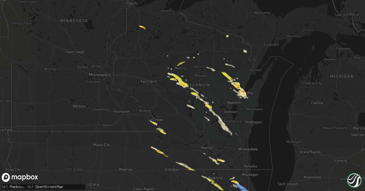
Hail Map in Wisconsin on June 24, 2026
Get this storm
June 24 map
$229
one time, instant access
Download today. No call, no setup
Keep the $229
Bought the map and want the full workflow? Apply the entire $229 to a subscription within 7 days. None of it is wasted.
Every map, not just this one
This buys you this map. Subscription and you get every map we run, in the markets you choose from a few cities to whole states to nationwide. Plus real-time alerts the moment a storm fires.
Contact data
Name, contact info, occupancy, even credit band for addresses in the footprint. You go from where it hit to who to call.
Become the source they trust
Unlimited branding weather history reports on demand. You already have the documented answer ready for the property owner, and you are the one who showed up with it.
Property data and RoofTrace estimates
Pull up any address you have got, its value and the exact code rules for that jurisdiction, straight from One Click Code. Then RoofTrace estimates the squares, pitch, and roof value, priced the way you price.
Storm reports in Wisconsin
Wisconsin
| Date | Description |
|---|---|
| 06/24/20266:10 PM CDT | Large tree branch down near intersection of elm st and west st. Time est from radar. |
| 06/24/20266:03 PM CDT | . |
| 06/24/20266:03 PM CDT | A local report indicates 1.50 inch wind near 1 SE Howard |
| 06/24/20266:01 PM CDT | Report from mping: half dollar |
| 06/24/20266:00 PM CDT | . |
| 06/24/20266:00 PM CDT | A local report indicates 1.75 inch wind near 2 SW Howard |
| 06/24/20265:52 PM CDT | . |
| 06/24/20265:52 PM CDT | A local report indicates 1.00 inch wind near 2 WSW Howard |
| 06/24/20265:37 PM CDT | Report from mping: quarter |
| 06/24/20265:25 PM CDT | A local report indicates 1.75 inch wind near Pulaski |
| 06/24/20265:25 PM CDT | . |
| 06/24/20265:20 PM CDT | A local report indicates 1.00 inch wind near 1 NNW Krakow |
| 06/24/20265:20 PM CDT | . |
| 06/24/20264:56 PM CDT | Report from mping: half dollar |
| 06/24/20264:39 PM CDT | Report from mping: quarter |
| 06/24/20264:25 PM CDT | Report of a downed powerline. |
| 06/24/20263:46 PM CDT | A local report indicates 1.25 inch wind near 2 SE Milton |
| 06/24/20263:34 PM CDT | Report from mping: half dollar |
| 06/24/20263:22 PM CDT | Tree down at lake rd and sidie hollow rd. |
| 06/24/20263:00 PM CDT | Power lines reported down south of belmont. |
| 06/24/20262:45 PM CDT | Report via social media with picture for reference. |
| 06/24/20262:43 PM CDT | Report from mping: quarter |
| 06/24/20262:10 PM CDT | A local report indicates 1.25 inch wind near 4 NNW Riplinger |
| 06/24/20261:40 PM CDT | A local report indicates 1.25 inch wind near Longwood |
| 06/24/202612:50 PM CDT | Report via social media photo. Location and time approximate. |
All States Impacted by Hail Map on June 24, 2026
Cities Impacted by Hail Map on June 24, 2026
- Carmen, OK
- Yale, OK
- Jennings, OK
- Drumright, OK
- Bristow, OK
- Okemah, OK
- Okmulgee, OK
- Henryetta, OK
- Council Hill, OK
- Morris, OK
- Checotah, OK
- Eufaula, OK
- Oak Hill, FL
- Edgewater, FL
- Opa Locka, FL
- Gordon, WI
- Orlando, FL
- Hialeah, FL
- Minong, WI
- Titusville, FL
- Cocoa, FL
- Webster, FL
- Greenwood, WI
- Kissimmee, FL
- Boca Raton, FL
- Pompano Beach, FL
- Deerfield Beach, FL
- Boynton Beach, FL
- Owen, WI
- Withee, WI
- Lake Worth, FL
- Loxahatchee, FL
- West Palm Beach, FL
- Saint Cloud, FL
- Thorp, WI
- Wellington, FL
- Medford, WI
- Raton, NM
- Loyal, WI
- Glen Flora, WI
- Floral City, FL
- Rib Lake, WI
- Westboro, WI
- Spencer, WI
- Brooksville, FL
- Caledonia, MN
- Hokah, MN
- Delray Beach, FL
- Houston, MN
- La Crescent, MN
- Inverness, FL
- Gilman, WI
- Bruce Crossing, MI
- Perkinston, MS
- Brownsville, MN
- Marshfield, WI
- Stoddard, WI
- Poplarville, MS
- Trout Creek, MI
- Lublin, WI
- Ogema, WI
- Carriere, MS
- Capitan, NM
- Cuba City, WI
- Platteville, WI
- Shullsburg, WI
- Tomahawk, WI
- Miami, FL
- Merrill, WI
- La Crosse, WI
- Genoa, WI
- Darlington, WI
- Belleville, WI
- Oregon, WI
- Brooklyn, WI
- Saucier, MS
- Viroqua, WI
- De Soto, WI
- Arpin, WI
- Wisconsin Rapids, WI
- Vesper, WI
- Biloxi, MS
- Evansville, WI
- White Lake, WI
- Townsend, WI
- Trinidad, CO
- Boncarbo, CO
- Las Vegas, NM
- Moriarty, NM
- McHenry, MS
- Lake Wales, FL
- Milladore, WI
- Babson Park, FL
- Frostproof, FL
- Fort Meade, FL
- Mountain, WI
- Vancleave, MS
- De Pere, WI
- Green Bay, WI
- Warren, IL
- Gratiot, WI
- Rudolph, WI
- Stevens Point, WI
- Guadalupita, NM
- Ocate, NM
- Janesville, WI
- Milton, WI
- McGregor, IA
- Monona, IA
- Iron River, MI
- Umatilla, FL
- Fort Huachuca, AZ
- Amite, LA
- Immokalee, FL
- Independence, LA
- Clewiston, FL
- Eustis, FL
- Edgerton, WI
- Vero Beach, FL
- Whitewater, WI
- Delavan, WI
- Necedah, WI
- Nekoosa, WI
- Neopit, WI
- Altoona, FL
- Tickfaw, LA
- Slidell, LA
- Winslow, IL
- Avalon, WI
- Bagley, WI
- Prairie Du Chien, WI
- Keshena, WI
- Aguilar, CO
- Fort Pierce, FL
- Sebring, FL
- Hammond, LA
- Bancroft, WI
- Loranger, LA
- Dunnellon, FL
- Lehigh Acres, FL
- Labelle, FL
- Long Lake, WI
- Avon Park, FL
- Arkdale, WI
- Briggsdale, CO
- Orchard, CO
- New Raymer, CO
- Gillett, WI
- Weldona, CO
- Curtiss, WI
- Colby, WI
- Corona, NM
- Caspian, MI
- Bloomington, WI
- Lake Placid, FL
- Okeechobee, FL
- Gaastra, MI
- Plainfield, WI
- Almond, WI
- Robert, LA
- Ponchatoula, LA
- Fort Morgan, CO
- Foster City, MI
- Wautoma, WI
- Wild Rose, WI
- Shawano, WI
- Bonduel, WI
- Hancock, WI
- Ocala, FL
- Patch Grove, WI
- Cecil, WI
- Unity, WI
- Freeport, IL
- Hillview, IL
- Merino, CO
- Snyder, CO
- Stoneham, CO
- Daphne, AL
- Patterson, IL
- Moore Haven, FL
- Claunch, NM
- Lancaster, WI
- Log Lane Village, CO
- Atoka, OK
- Krakow, WI
- Pulaski, WI
- Wiggins, CO
- Atwood, CO
- Roodhouse, IL
- White Hall, IL
- Carrollton, IL
- Ridott, IL
- Sagola, MI
- Waupaca, WI
- Salem, MO
- Bunker, MO
- Iron Mountain, MI
- Watrous, NM
- Valmora, NM
- Wagon Mound, NM
- Seymour, WI
- Rockbridge, IL
- Weston, CO
- Douglas, WY
- Winnebago, IL
- Pecatonica, IL
- Neshkoro, WI
- Berlin, WI
- Redgranite, WI
- Robertsdale, AL
- Otis, CO
- Akron, CO
- Sterling, CO
- Hillrose, CO
- Sierra Vista, AZ
- Hereford, AZ
- Elgin, AZ
- Vail, AZ
- Carlsbad, NM
- Huntley, IL
- Lake In The Hills, IL
- Crystal Lake, IL
- Algonquin, IL
- Byron, IL
- Leaf River, IL
- Seminole, AL
- Oneida, WI
- Brush, CO
- Coloma, WI
- Stratford, WI
- Vaughn, NM
- Medora, IL
- Abbotsford, WI
- Green Lake, WI
- Greenfield, IL
- Ellington, MO
- Wrights, IL
- Stockton, UT
- Woodstock, IL
- Dundee, IL
- Carpentersville, IL
- Guernsey, WY
- Wheatland, WY
- Barrington, IL
- Auburndale, WI
- Chesterfield, IL
- Shipman, IL
- Lindenwood, IL
- Davis Junction, IL
- Monroe Center, IL
- Stillman Valley, IL
- Rochelle, IL
- Holcomb, IL
- Rockford, IL
- Denmark, WI
- Antigo, WI
- Union, IL
- Indiantown, FL
- Montello, WI
- Westfield, WI
- Woodrow, CO
- Hettick, IL
- Ripon, WI
- Gilberts, IL
- Black Creek, WI
- Sterling, IL
- Morrison, IL
- Roswell, NM
- Shiocton, WI
- Princeton, WI
- Dixon, IL
- Clare, IL
- Malta, IL
- Kirkland, IL
- Esmond, IL
- Bunker Hill, IL
- Gillespie, IL
- Elgin, IL
- Hampshire, IL
- Junction City, WI
- Brandon, WI
- Fairwater, WI
- Rainsville, NM
- Markesan, WI
- Hoffman Estates, IL
- Elk Grove Village, IL
- Medinah, IL
- Schaumburg, IL
- Itasca, IL
- Streamwood, IL
- Hanover Park, IL
- Roselle, IL
- Wood Dale, IL
- Waupun, WI
- Sidney, NE
- Peetz, CO
- Rock River, WY
- La Salle, IL
- Oglesby, IL
- Utica, IL
- Ottawa, IL
- Stanley, NM
- Bartlett, IL
- San Jose, NM
- Ribera, NM
- South Elgin, IL
- Bosler, WY
- Harmon, IL
- Amboy, IL
- Rock Falls, IL
- Peru, IL
- Crook, CO
- Pecos, NM
- Elberta, AL
- Ogallala, NE
- Brule, NE
- Lewellen, NE
- Bloomingdale, IL
- Addison, IL
- Glendale Heights, IL
- Lombard, IL
- Wheaton, IL
- Carol Stream, IL
- Elmhurst, IL
- Glen Ellyn, IL
- Villa Park, IL
- Bensenville, IL
- Winfield, IL
- Iliff, CO
- Grand Ridge, IL
- Fox Lake, WI
- Lodgepole, NE
- Big Springs, NE
- Sublette, IL
- Ohio, IL
- Plover, WI
- Staunton, IL
- Kaukauna, WI
- Chappell, NE
- Deer Grove, IL
- Streator, IL
- Burnett, WI
- Beaver Dam, WI
- Melrose Park, IL
- Oak Brook, IL
- La Moille, IL
- Mayville, WI
- Edelstein, IL
- Metamora, IL
- East Peoria, IL
- Dunlap, IL
- Peoria, IL
- Chillicothe, IL
- Fleming, CO
- Haxtun, CO
- Yoder, WY
- Garrett, WY
- Pembine, WI
- Dunbar, WI
- Saratoga, WY
- Hanna, WY
- Riverside, IL
- La Grange Park, IL
- Brookfield, IL
- La Grange, IL
- Lyons, IL
- Washington, IL
- Morris, IL
- Newark, IL
- Walnut, IL
- Amherst, WI
- Anton Chico, NM
- Broadview, IL
- Berwyn, IL
- Mendota, IL
- Arlington, IL
- Bellwood, IL
- Cicero, IL
- Stone Park, IL
- Forest Park, IL
- Berkeley, IL
- Hillside, IL
- Hinsdale, IL
- Maywood, IL
- River Forest, IL
- Westchester, IL
- Hines, IL
- Tonica, IL
- Roanoke, IL
- Eureka, IL
- Amberg, WI
- Grover, CO
- Iron Ridge, WI
- Paxton, NE
- Evergreen Park, IL
- Chicago, IL
- Grant, NE
- Horicon, WI
- Broken Bow, NE
- Hometown, IL
- Alsip, IL
- Worth, IL
- Burbank, IL
- Justice, IL
- Hickory Hills, IL
- Chicago Ridge, IL
- Oak Lawn, IL
- Bridgeview, IL
- Hagerman, NM
- Willowbrook, IL
- Downers Grove, IL
- Westmont, IL
- Summit Argo, IL
- Willow Springs, IL
- Oak Park, IL
- Palos Hills, IL
- Western Springs, IL
- Franklin Park, IL
- Clarendon Hills, IL
- Robbins, IL
- Harvey, IL
- Blue Island, IL
- Dolton, IL
- Posen, IL
- South Holland, IL
- Riverdale, IL
- Madrid, NE
- Santa Rosa, NM
- Lisco, NE
- Hershey, NE
- Blackstone, IL
- Kinsman, IL
- Ransom, IL
- Allenton, WI
- West Bend, WI
- Carpenter, WY
- Hereford, CO
- North Platte, NE
- Yeso, NM
- Dwight, IL
- Lusk, WY
- Elsie, NE
- Cope, CO
- Stapleton, NE
- Griffith, IN
- Highland, IN
- Gary, IN
- Munster, IN
- Schererville, IN
- Hammond, IN
- East Chicago, IN
- Calumet City, IL
- Oshkosh, NE
- Lansing, IL
- Merrillville, IN
- Chicago Heights, IL
- Dyer, IN
- Anton, CO
- Odell, IL
- Cuervo, NM
- Arthur, NE
- Crete, IL
- Paoli, CO
- Gothenburg, NE
- Deltona, FL
- Leonore, IL
- Tucumcari, NM
- Mcalister, NM
- Valparaiso, IN
- Crown Point, IN
- Hobart, IN
- Hebron, IN
- Imperial, NE
- Wauneta, NE
- Enders, NE
- Brady, NE
- Cheyenne, WY
- Loveland, CO
- Berthoud, CO
- Callaway, NE
- Tryon, NE
- Ansley, NE
- Crossroads, NM
- Maywood, NE
- Maxwell, NE
- Curtis, NE
- Wellfleet, NE
- Palisade, NE
- Elida, NM
- Johnstown, CO
- Cozad, NE
- Hobbs, NM
- Medicine Bow, WY
- House, NM
- Lake Helen, FL
- Glendo, WY
- Willow Island, NE
- Pep, NM
- Rogers, NM
- Rawlins, WY
- Port Saint Lucie, FL
- Eustis, NE
- Lexington, NE
- Elwood, NE
- Julesburg, CO
- Burns, WY
- Hillsdale, WY
- Melrose, NM
- Amherst, CO
- Holyoke, CO
- Dekalb, IL
- Portales, NM
- Alcova, WY
- Stratton, NE
- Sobieski, WI
- Amherst, TX
- Sedgwick, CO
- Longmont, CO
- Littlefield, TX
- Smithfield, NE
- Rock City, IL
- Chenoa, IL
- Pontiac, IL
- Fairbury, IL
- Venango, NE
- Champion, NE
- Moorefield, NE
- Strasburg, CO
- Byers, CO
- Evergreen, CO
- Anton, TX
- Bertrand, NE
- Lambert, MS
- Bennett, CO
- Hickory Ridge, AR
- Lindon, CO
- Edison, NE
- Lander, WY
- Oxford, NE
- Indian Hills, CO
- Morrison, CO
- Yuma, CO
- Wynne, AR
- Conifer, CO
- Abernathy, TX
- Littleton, CO
- Clovis, NM
- Texico, NM
- Friona, TX
- Muleshoe, TX
- Deer Trail, CO
- Enid, MS
- Denver, CO
- Farwell, TX
- Orleans, NE
- Bovina, TX
- Englewood, CO
- Charleston, MS
- Tillatoba, MS
- Stamford, NE
- Dimmitt, TX
- Riverton, WY
- Alma, NE
- Hart, TX
- Benkelman, NE
- Hereford, TX
- Shallowater, TX
- Parks, NE
- Logan, KS
- Lenora, KS
- Happy, TX
- Nazareth, TX
- Tulia, TX
- Canyon, TX
- Phillipsburg, KS
- Vega, TX
- Wildorado, TX
- Amarillo, TX
- Eckley, CO
- Agra, KS
- Oberlin, KS
- Flagler, CO
- McCook, NE
- Golden, CO
- Kirwin, KS
- Glade, KS
- Claude, TX
- Wayside, TX
- Panhandle, TX
- Idalia, CO
- Wray, CO
- Vernon, CO
- Stockton, KS
- Woodston, KS
- Portis, KS
- Osborne, KS
- Alton, KS
- Norcatur, KS
- Downs, KS
- Wakefield, KS
- Groom, TX
- Junction City, KS
- Chapman, KS
- Milford, KS
- Brewster, KS
- Edson, KS
- Levant, KS
- Colby, KS
- Winona, KS
- Sparkman, AR
- Park, KS
- Gove, KS
- West Union, IL
- Marshall, IL
- Grainfield, KS
- Scott City, KS
- Leoti, KS
- Fairbanks, IN
- Sullivan, IN
- Merom, IN
- Quinter, KS
- Garden City, KS
- Hermitage, AR
- Dighton, KS
- Buffalo, OK
- Cimarron, KS
- Coldwater, KS
- Freedom, OK
- Healy, KS
- Chugwater, WY
- Tatum, NM


