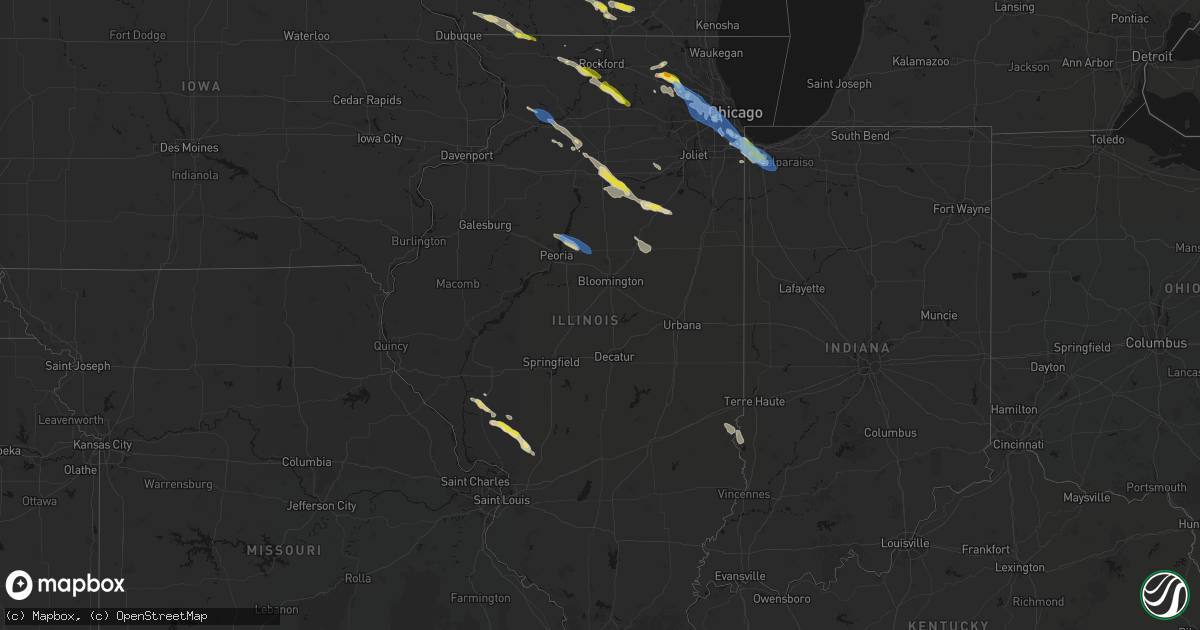
Hail Map in Illinois on June 24, 2026
Get this storm
June 24 map
$229
one time, instant access
Download today. No call, no setup
Keep the $229
Bought the map and want the full workflow? Apply the entire $229 to a subscription within 7 days. None of it is wasted.
Every map, not just this one
This buys you this map. Subscription and you get every map we run, in the markets you choose from a few cities to whole states to nationwide. Plus real-time alerts the moment a storm fires.
Contact data
Name, contact info, occupancy, even credit band for addresses in the footprint. You go from where it hit to who to call.
Become the source they trust
Unlimited branding weather history reports on demand. You already have the documented answer ready for the property owner, and you are the one who showed up with it.
Property data and RoofTrace estimates
Pull up any address you have got, its value and the exact code rules for that jurisdiction, straight from One Click Code. Then RoofTrace estimates the squares, pitch, and roof value, priced the way you price.
Storm reports in Illinois
Illinois
| Date | Description |
|---|---|
| 06/24/20266:45 PM CDT | Bloomingdale pd reports tree branches downed onto schick road near springfield drive. Time estimated by radar. |
| 06/24/20266:40 PM CDT | Six inch diameter tree limb blown down on ring court. |
| 06/24/20266:39 PM CDT | Large tree branches... Fence posts... And fence panels downed. |
| 06/24/20266:39 PM CDT | Large tree limb snapped and downed onto multiple parked vehicles. |
| 06/24/20266:39 PM CDT | Private weather station kilhanovi2 measured a wind gust to 58 mph. |
| 06/24/20266:38 PM CDT | Four inch diameter tree limbs blown down. |
| 06/24/20266:36 PM CDT | Tree limbs and power lines blown down in bartlett. |
| 06/24/20266:36 PM CDT | Photos shared to social media show numerous large branches downed at bartlett hills golf course. One large tree snaped near the base. Small branches scattered across th |
| 06/24/20266:35 PM CDT | Photo shared to social media shows uprooted tree in streamwood. Time estimated by social media. |
| 06/24/20266:27 PM CDT | Multiple photos and videos shared to social media show large branches downed... Trees uprooted... Trees snapped... Across the streamwood area. At least one large tree t |
| 06/24/20266:26 PM CDT | Photo shared to social media shows multiple hail stones of nickel size and one stone of quarter size near rich road and schafer road. Time estimated by radar. |
| 06/24/20266:18 PM CDT | Tree branches downed at lords park in elgin. Time estimated by radar. |
| 06/24/20266:16 PM CDT | Kane county forest preserve district reports multiple large branches broken... At least one tree snapped at the base... In voyageur landing forest preserve near elgin. |
| 06/24/20266:13 PM CDT | Kane county ema reported multiple large branches downed near barrington avenue and water street in east dundee. Time estimated by radar. |
| 06/24/20266:12 PM CDT | Photo shared on social media showing a large tree branch downed in sleepy hollow. Time estimated from radar. |
| 06/24/20266:10 PM CDT | Large tree branch blown down. Time estimated from radar. |
| 06/24/20266:03 PM CDT | 50 to 60 mph wind gusts with torrential rain. |
| 06/24/20265:59 PM CDT | Public report of quarter size hail southeast of algonquin. Relayed via mping. |
| 06/24/20265:57 PM CDT | Mchenry county ema reports quarter size hail near randall road and harnish drive. |
| 06/24/20265:55 PM CDT | Report from mping: quarter |
| 06/24/20265:55 PM CDT | Report from mping: quarter |
| 06/24/20265:54 PM CDT | Multiple public reports of quarter size hail near algonquin. Relayed via mping. |
| 06/24/20265:42 PM CDT | Quarter size hail near byron. Relayed via amateur radio. Time estimated by radar. |
| 06/24/20265:41 PM CDT | Public report of 1.5 inch hail near huntley. Relayed via mping. |
| 06/24/20265:41 PM CDT | Public report of 1.5 inch hail near huntly. Relayed via mping. |
| 06/24/20265:39 PM CDT | A local report indicates 1.00 inch wind near 1 NE Huntley |
| 06/24/20265:34 PM CDT | Mchenry county ema reports roof damage to barn along harmony road near brier hill road. Video shared to social media shows likely tornado with lofted debris in the vici |
| 06/24/20264:07 PM CDT | Power lines down in front yard. |
| 06/23/20267:45 PM CDT | Scattered public reports of tree branches downed in the roseland... North pullman... And west pullman community areas of chicago. Relayed via chicago 311. Time estimate |
| 06/23/20267:41 PM CDT | Numerous public reports of tree branches downed in the mount greenwood... Beverly... Washington heights... And morgan park community areas of chicago. Relayed via chica |
| 06/23/20267:35 PM CDT | Photos shared to social media show multiple large branches downed... One tree snapped at the base... Near 99th street and california avenue. Time estimated by radar. |
| 06/23/20267:26 PM CDT | Multiple public reports of downed tree branches in the edgewater and uptown community areas of chicago. Relayed via chicago 311. Time estimated by radar. |
| 06/23/20267:24 PM CDT | A local report indicates 60 MPH wind near 1 NNE Metamora |
All States Impacted by Hail Map on June 24, 2026
Cities Impacted by Hail Map on June 24, 2026
- Carmen, OK
- Yale, OK
- Jennings, OK
- Drumright, OK
- Bristow, OK
- Okemah, OK
- Okmulgee, OK
- Henryetta, OK
- Council Hill, OK
- Morris, OK
- Checotah, OK
- Eufaula, OK
- Oak Hill, FL
- Edgewater, FL
- Opa Locka, FL
- Gordon, WI
- Orlando, FL
- Hialeah, FL
- Minong, WI
- Titusville, FL
- Cocoa, FL
- Webster, FL
- Greenwood, WI
- Kissimmee, FL
- Boca Raton, FL
- Pompano Beach, FL
- Deerfield Beach, FL
- Boynton Beach, FL
- Owen, WI
- Withee, WI
- Lake Worth, FL
- Loxahatchee, FL
- West Palm Beach, FL
- Saint Cloud, FL
- Thorp, WI
- Wellington, FL
- Medford, WI
- Raton, NM
- Loyal, WI
- Glen Flora, WI
- Floral City, FL
- Rib Lake, WI
- Westboro, WI
- Spencer, WI
- Brooksville, FL
- Caledonia, MN
- Hokah, MN
- Delray Beach, FL
- Houston, MN
- La Crescent, MN
- Inverness, FL
- Gilman, WI
- Bruce Crossing, MI
- Perkinston, MS
- Brownsville, MN
- Marshfield, WI
- Stoddard, WI
- Poplarville, MS
- Trout Creek, MI
- Lublin, WI
- Ogema, WI
- Carriere, MS
- Capitan, NM
- Cuba City, WI
- Platteville, WI
- Shullsburg, WI
- Tomahawk, WI
- Miami, FL
- Merrill, WI
- La Crosse, WI
- Genoa, WI
- Darlington, WI
- Belleville, WI
- Oregon, WI
- Brooklyn, WI
- Saucier, MS
- Viroqua, WI
- De Soto, WI
- Arpin, WI
- Wisconsin Rapids, WI
- Vesper, WI
- Biloxi, MS
- Evansville, WI
- White Lake, WI
- Townsend, WI
- Trinidad, CO
- Boncarbo, CO
- Las Vegas, NM
- Moriarty, NM
- McHenry, MS
- Lake Wales, FL
- Milladore, WI
- Babson Park, FL
- Frostproof, FL
- Fort Meade, FL
- Mountain, WI
- Vancleave, MS
- De Pere, WI
- Green Bay, WI
- Warren, IL
- Gratiot, WI
- Rudolph, WI
- Stevens Point, WI
- Guadalupita, NM
- Ocate, NM
- Janesville, WI
- Milton, WI
- McGregor, IA
- Monona, IA
- Iron River, MI
- Umatilla, FL
- Fort Huachuca, AZ
- Amite, LA
- Immokalee, FL
- Independence, LA
- Clewiston, FL
- Eustis, FL
- Edgerton, WI
- Vero Beach, FL
- Whitewater, WI
- Delavan, WI
- Necedah, WI
- Nekoosa, WI
- Neopit, WI
- Altoona, FL
- Tickfaw, LA
- Slidell, LA
- Winslow, IL
- Avalon, WI
- Bagley, WI
- Prairie Du Chien, WI
- Keshena, WI
- Aguilar, CO
- Fort Pierce, FL
- Sebring, FL
- Hammond, LA
- Bancroft, WI
- Loranger, LA
- Dunnellon, FL
- Lehigh Acres, FL
- Labelle, FL
- Long Lake, WI
- Avon Park, FL
- Arkdale, WI
- Briggsdale, CO
- Orchard, CO
- New Raymer, CO
- Gillett, WI
- Weldona, CO
- Curtiss, WI
- Colby, WI
- Corona, NM
- Caspian, MI
- Bloomington, WI
- Lake Placid, FL
- Okeechobee, FL
- Gaastra, MI
- Plainfield, WI
- Almond, WI
- Robert, LA
- Ponchatoula, LA
- Fort Morgan, CO
- Foster City, MI
- Wautoma, WI
- Wild Rose, WI
- Shawano, WI
- Bonduel, WI
- Hancock, WI
- Ocala, FL
- Patch Grove, WI
- Cecil, WI
- Unity, WI
- Freeport, IL
- Hillview, IL
- Merino, CO
- Snyder, CO
- Stoneham, CO
- Daphne, AL
- Patterson, IL
- Moore Haven, FL
- Claunch, NM
- Lancaster, WI
- Log Lane Village, CO
- Atoka, OK
- Krakow, WI
- Pulaski, WI
- Wiggins, CO
- Atwood, CO
- Roodhouse, IL
- White Hall, IL
- Carrollton, IL
- Ridott, IL
- Sagola, MI
- Waupaca, WI
- Salem, MO
- Bunker, MO
- Iron Mountain, MI
- Watrous, NM
- Valmora, NM
- Wagon Mound, NM
- Seymour, WI
- Rockbridge, IL
- Weston, CO
- Douglas, WY
- Winnebago, IL
- Pecatonica, IL
- Neshkoro, WI
- Berlin, WI
- Redgranite, WI
- Robertsdale, AL
- Otis, CO
- Akron, CO
- Sterling, CO
- Hillrose, CO
- Sierra Vista, AZ
- Hereford, AZ
- Elgin, AZ
- Vail, AZ
- Carlsbad, NM
- Huntley, IL
- Lake In The Hills, IL
- Crystal Lake, IL
- Algonquin, IL
- Byron, IL
- Leaf River, IL
- Seminole, AL
- Oneida, WI
- Brush, CO
- Coloma, WI
- Stratford, WI
- Vaughn, NM
- Medora, IL
- Abbotsford, WI
- Green Lake, WI
- Greenfield, IL
- Ellington, MO
- Wrights, IL
- Stockton, UT
- Woodstock, IL
- Dundee, IL
- Carpentersville, IL
- Guernsey, WY
- Wheatland, WY
- Barrington, IL
- Auburndale, WI
- Chesterfield, IL
- Shipman, IL
- Lindenwood, IL
- Davis Junction, IL
- Monroe Center, IL
- Stillman Valley, IL
- Rochelle, IL
- Holcomb, IL
- Rockford, IL
- Denmark, WI
- Antigo, WI
- Union, IL
- Indiantown, FL
- Montello, WI
- Westfield, WI
- Woodrow, CO
- Hettick, IL
- Ripon, WI
- Gilberts, IL
- Black Creek, WI
- Sterling, IL
- Morrison, IL
- Roswell, NM
- Shiocton, WI
- Princeton, WI
- Dixon, IL
- Clare, IL
- Malta, IL
- Kirkland, IL
- Esmond, IL
- Bunker Hill, IL
- Gillespie, IL
- Elgin, IL
- Hampshire, IL
- Junction City, WI
- Brandon, WI
- Fairwater, WI
- Rainsville, NM
- Markesan, WI
- Hoffman Estates, IL
- Elk Grove Village, IL
- Medinah, IL
- Schaumburg, IL
- Itasca, IL
- Streamwood, IL
- Hanover Park, IL
- Roselle, IL
- Wood Dale, IL
- Waupun, WI
- Sidney, NE
- Peetz, CO
- Rock River, WY
- La Salle, IL
- Oglesby, IL
- Utica, IL
- Ottawa, IL
- Stanley, NM
- Bartlett, IL
- San Jose, NM
- Ribera, NM
- South Elgin, IL
- Bosler, WY
- Harmon, IL
- Amboy, IL
- Rock Falls, IL
- Peru, IL
- Crook, CO
- Pecos, NM
- Elberta, AL
- Ogallala, NE
- Brule, NE
- Lewellen, NE
- Bloomingdale, IL
- Addison, IL
- Glendale Heights, IL
- Lombard, IL
- Wheaton, IL
- Carol Stream, IL
- Elmhurst, IL
- Glen Ellyn, IL
- Villa Park, IL
- Bensenville, IL
- Winfield, IL
- Iliff, CO
- Grand Ridge, IL
- Fox Lake, WI
- Lodgepole, NE
- Big Springs, NE
- Sublette, IL
- Ohio, IL
- Plover, WI
- Staunton, IL
- Kaukauna, WI
- Chappell, NE
- Deer Grove, IL
- Streator, IL
- Burnett, WI
- Beaver Dam, WI
- Melrose Park, IL
- Oak Brook, IL
- La Moille, IL
- Mayville, WI
- Edelstein, IL
- Metamora, IL
- East Peoria, IL
- Dunlap, IL
- Peoria, IL
- Chillicothe, IL
- Fleming, CO
- Haxtun, CO
- Yoder, WY
- Garrett, WY
- Pembine, WI
- Dunbar, WI
- Saratoga, WY
- Hanna, WY
- Riverside, IL
- La Grange Park, IL
- Brookfield, IL
- La Grange, IL
- Lyons, IL
- Washington, IL
- Morris, IL
- Newark, IL
- Walnut, IL
- Amherst, WI
- Anton Chico, NM
- Broadview, IL
- Berwyn, IL
- Mendota, IL
- Arlington, IL
- Bellwood, IL
- Cicero, IL
- Stone Park, IL
- Forest Park, IL
- Berkeley, IL
- Hillside, IL
- Hinsdale, IL
- Maywood, IL
- River Forest, IL
- Westchester, IL
- Hines, IL
- Tonica, IL
- Roanoke, IL
- Eureka, IL
- Amberg, WI
- Grover, CO
- Iron Ridge, WI
- Paxton, NE
- Evergreen Park, IL
- Chicago, IL
- Grant, NE
- Horicon, WI
- Broken Bow, NE
- Hometown, IL
- Alsip, IL
- Worth, IL
- Burbank, IL
- Justice, IL
- Hickory Hills, IL
- Chicago Ridge, IL
- Oak Lawn, IL
- Bridgeview, IL
- Hagerman, NM
- Willowbrook, IL
- Downers Grove, IL
- Westmont, IL
- Summit Argo, IL
- Willow Springs, IL
- Oak Park, IL
- Palos Hills, IL
- Western Springs, IL
- Franklin Park, IL
- Clarendon Hills, IL
- Robbins, IL
- Harvey, IL
- Blue Island, IL
- Dolton, IL
- Posen, IL
- South Holland, IL
- Riverdale, IL
- Madrid, NE
- Santa Rosa, NM
- Lisco, NE
- Hershey, NE
- Blackstone, IL
- Kinsman, IL
- Ransom, IL
- Allenton, WI
- West Bend, WI
- Carpenter, WY
- Hereford, CO
- North Platte, NE
- Yeso, NM
- Dwight, IL
- Lusk, WY
- Elsie, NE
- Cope, CO
- Stapleton, NE
- Griffith, IN
- Highland, IN
- Gary, IN
- Munster, IN
- Schererville, IN
- Hammond, IN
- East Chicago, IN
- Calumet City, IL
- Oshkosh, NE
- Lansing, IL
- Merrillville, IN
- Chicago Heights, IL
- Dyer, IN
- Anton, CO
- Odell, IL
- Cuervo, NM
- Arthur, NE
- Crete, IL
- Paoli, CO
- Gothenburg, NE
- Deltona, FL
- Leonore, IL
- Tucumcari, NM
- Mcalister, NM
- Valparaiso, IN
- Crown Point, IN
- Hobart, IN
- Hebron, IN
- Imperial, NE
- Wauneta, NE
- Enders, NE
- Brady, NE
- Cheyenne, WY
- Loveland, CO
- Berthoud, CO
- Callaway, NE
- Tryon, NE
- Ansley, NE
- Crossroads, NM
- Maywood, NE
- Maxwell, NE
- Curtis, NE
- Wellfleet, NE
- Palisade, NE
- Elida, NM
- Johnstown, CO
- Cozad, NE
- Hobbs, NM
- Medicine Bow, WY
- House, NM
- Lake Helen, FL
- Glendo, WY
- Willow Island, NE
- Pep, NM
- Rogers, NM
- Rawlins, WY
- Port Saint Lucie, FL
- Eustis, NE
- Lexington, NE
- Elwood, NE
- Julesburg, CO
- Burns, WY
- Hillsdale, WY
- Melrose, NM
- Amherst, CO
- Holyoke, CO
- Dekalb, IL
- Portales, NM
- Alcova, WY
- Stratton, NE
- Sobieski, WI
- Amherst, TX
- Sedgwick, CO
- Longmont, CO
- Littlefield, TX
- Smithfield, NE
- Rock City, IL
- Chenoa, IL
- Pontiac, IL
- Fairbury, IL
- Venango, NE
- Champion, NE
- Moorefield, NE
- Strasburg, CO
- Byers, CO
- Evergreen, CO
- Anton, TX
- Bertrand, NE
- Lambert, MS
- Bennett, CO
- Hickory Ridge, AR
- Lindon, CO
- Edison, NE
- Lander, WY
- Oxford, NE
- Indian Hills, CO
- Morrison, CO
- Yuma, CO
- Wynne, AR
- Conifer, CO
- Abernathy, TX
- Littleton, CO
- Clovis, NM
- Texico, NM
- Friona, TX
- Muleshoe, TX
- Deer Trail, CO
- Enid, MS
- Denver, CO
- Farwell, TX
- Orleans, NE
- Bovina, TX
- Englewood, CO
- Charleston, MS
- Tillatoba, MS
- Stamford, NE
- Dimmitt, TX
- Riverton, WY
- Alma, NE
- Hart, TX
- Benkelman, NE
- Hereford, TX
- Shallowater, TX
- Parks, NE
- Logan, KS
- Lenora, KS
- Happy, TX
- Nazareth, TX
- Tulia, TX
- Canyon, TX
- Phillipsburg, KS
- Vega, TX
- Wildorado, TX
- Amarillo, TX
- Eckley, CO
- Agra, KS
- Oberlin, KS
- Flagler, CO
- McCook, NE
- Golden, CO
- Kirwin, KS
- Glade, KS
- Claude, TX
- Wayside, TX
- Panhandle, TX
- Idalia, CO
- Wray, CO
- Vernon, CO
- Stockton, KS
- Woodston, KS
- Portis, KS
- Osborne, KS
- Alton, KS
- Norcatur, KS
- Downs, KS
- Wakefield, KS
- Groom, TX
- Junction City, KS
- Chapman, KS
- Milford, KS
- Brewster, KS
- Edson, KS
- Levant, KS
- Colby, KS
- Winona, KS
- Sparkman, AR
- Park, KS
- Gove, KS
- West Union, IL
- Marshall, IL
- Grainfield, KS
- Scott City, KS
- Leoti, KS
- Fairbanks, IN
- Sullivan, IN
- Merom, IN
- Quinter, KS
- Garden City, KS
- Hermitage, AR
- Dighton, KS
- Buffalo, OK
- Cimarron, KS
- Coldwater, KS
- Freedom, OK
- Healy, KS
- Chugwater, WY
- Tatum, NM


