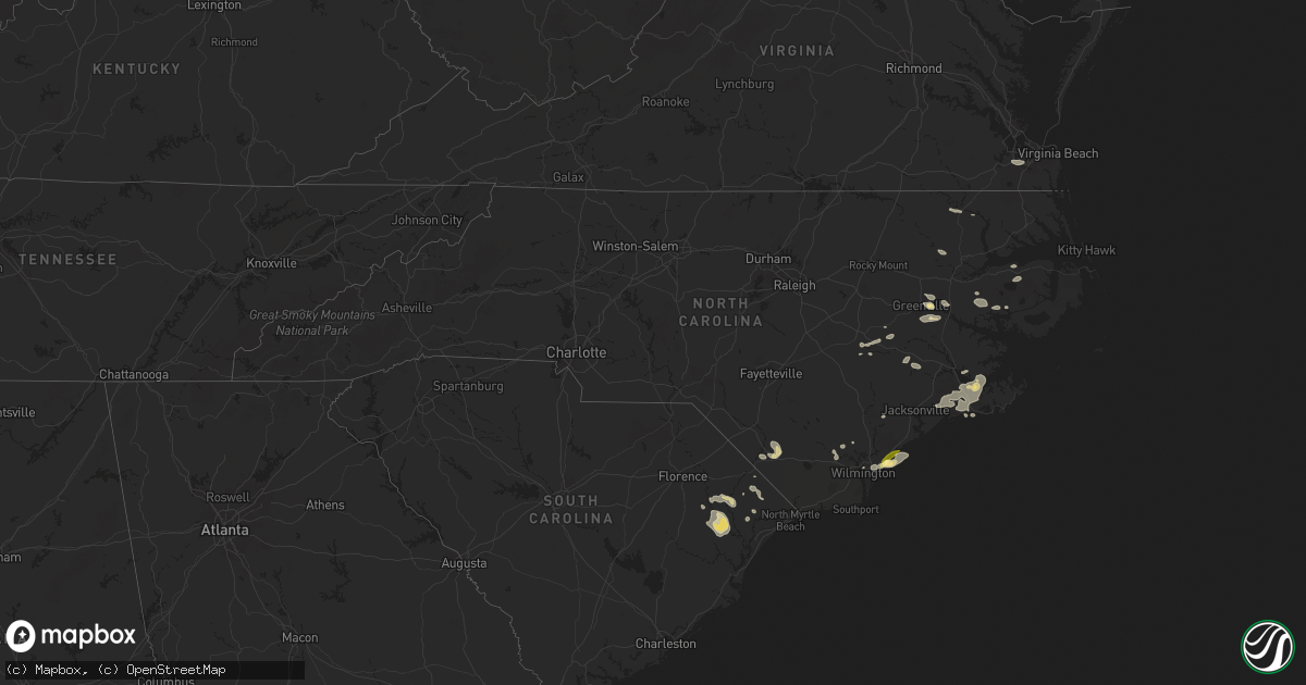
Hail Map in North Carolina on June 24, 2024
Get this storm
June 24 map
$229
one time, instant access
Download today. No call, no setup
Keep the $229
Bought the map and want the full workflow? Apply the entire $229 to a subscription within 7 days. None of it is wasted.
Every map, not just this one
This buys you this map. Subscription and you get every map we run, in the markets you choose from a few cities to whole states to nationwide. Plus real-time alerts the moment a storm fires.
Contact data
Name, contact info, occupancy, even credit band for addresses in the footprint. You go from where it hit to who to call.
Become the source they trust
Unlimited branding weather history reports on demand. You already have the documented answer ready for the property owner, and you are the one who showed up with it.
Property data and RoofTrace estimates
Pull up any address you have got, its value and the exact code rules for that jurisdiction, straight from One Click Code. Then RoofTrace estimates the squares, pitch, and roof value, priced the way you price.
Storm reports in North Carolina
North Carolina
| Date | Description |
|---|---|
| 06/24/20244:58 PM CDT | Kmrh reported a gust of 55 knots. |
| 06/24/20244:51 PM CDT | Xmac fort macon weatherflow station gusted to 57 kt. |
| 06/24/20243:30 PM CDT | A local report indicates 1.00 inch wind near 2 NNW Topsail Beach |
| 06/24/20243:22 PM CDT | Approximately 100 power outages in the bridgeton area near highway 17 per duke energy. The time was estimated based on radar data. |
| 06/24/20243:20 PM CDT | A local report indicates 1.00 inch wind near 1 SSE Hampstead |
| 06/24/20243:17 PM CDT | A local report indicates 1.00 inch wind near 2 ENE Bayshore |
| 06/24/20243:17 PM CDT | Large tree limb broken by thunderstorm winds on futch creek rd |
| 06/24/20242:58 PM CDT | Jones-onslow electric coop reports three areas of power outages... With trees and limbs blown down on powerlines between trenton and pollocksville. The time was estimat |
| 06/24/20242:14 PM CDT | Witn article of large tree which fell... That damaged a barn and vehicles in chocowinity. The time was estimated based on radar data. |
| 06/24/20241:48 PM CDT | Area of power outages noted north of kinston per duke energy. The time was estimated based on radar data. |
| 06/24/20241:31 PM CDT | Several customers without power in wanchese due to damage to power lines. Time estimated from radar. |
| 06/24/202412:47 PM CDT | Report relayed from social media. |
All States Impacted by Hail Map on June 24, 2024
Cities Impacted by Hail Map on June 24, 2024
- Earleville, MD
- Portal, ND
- Flaxton, ND
- Lignite, ND
- Columbus, ND
- Sutton, ND
- Glenfield, ND
- Carrington, ND
- Murfreesboro, NC
- Ahoskie, NC
- Winton, NC
- Chesapeake, VA
- Portsmouth, VA
- Cofield, NC
- Creswell, NC
- Snow Hill, NC
- Lewiston Woodville, NC
- La Grange, NC
- Dudley, NC
- Windsor, NC
- Kinston, NC
- Greenville, NC
- Goldsboro, NC
- Grimesland, NC
- Washington, NC
- Ayden, NC
- Winterville, NC
- Stokes, NC
- Bethel, NC
- Pantego, NC
- Plymouth, NC
- Seven Springs, NC
- Belhaven, NC
- Pinetown, NC
- Mount Olive, NC
- Eglin Afb, FL
- Trenton, NC
- Dover, NC
- Jamesville, NC
- Chocowinity, NC
- Wilmington, NC
- Havelock, NC
- New Bern, NC
- Grantsboro, NC
- Hampstead, NC
- Holly Ridge, NC
- Arapahoe, NC
- Maysville, NC
- Union, MS
- Oriental, NC
- Hubert, NC
- Stella, NC
- Swansboro, NC
- Pass Christian, MS
- Gulfport, MS
- Newport, NC
- Maple Hill, NC
- Seligman, AZ
- Williams, AZ
- Claremont, MN
- Dodge Center, MN
- Byron, MN
- Atlantic Beach, NC
- Kasson, MN
- Salter Path, NC
- Emerald Isle, NC
- Rochester, MN
- Hayes Center, NE
- Rushford, MN
- Peterson, MN
- Chatfield, MN
- Caledonia, MN
- Houston, MN
- Roseau, MN
- Clarkton, NC
- Whiteville, NC
- Bladenboro, NC
- Evergreen, NC
- Salol, MN
- Warroad, MN
- Hot Springs, SD
- Oelrichs, SD
- Newfolden, MN
- Viking, MN
- Chadron, NE
- Miami, AZ
- Hokah, MN
- Smithwick, SD
- Wannaska, MN
- Hay Springs, NE
- Brownsville, MN
- Chadbourn, NC
- Cerro Gordo, NC
- Thief River Falls, MN
- Stoddard, WI
- Rushville, NE
- Middle River, MN
- Genoa, WI
- De Soto, WI
- Charleston, MS
- Pine Ridge, SD
- Ellsworth, NE
- Westby, WI
- Viroqua, WI
- Chaseburg, WI
- Kingman, AZ
- Minter City, MS
- Oral, SD
- Goodridge, MN
- Richland Center, WI
- Soldiers Grove, WI
- Blue River, WI
- Muscoda, WI
- Readstown, WI
- Ponchatoula, LA
- Viola, WI
- Springfield, LA
- Merriman, NE
- Sauk City, WI
- Hillsboro, WI
- Wonewoc, WI
- La Valle, WI
- Kelly, NC
- Atkinson, NC
- Currie, NC
- Newell, SD
- Riegelwood, NC
- Batesland, SD
- Delco, NC
- Gordon, NE
- Mazomanie, WI
- Cazenovia, WI
- Black Earth, WI
- Verona, WI
- Barneveld, WI
- Blue Mounds, WI
- Lone Rock, WI
- Plain, WI
- Hillpoint, WI
- Elroy, WI
- Mauston, WI
- Lime Ridge, WI
- Custer, SD
- Baudette, MN
- Lyndon Station, WI
- Mount Horeb, WI
- Loris, SC
- Nichols, SC
- Reedsburg, WI
- Wisconsin Dells, WI
- Albany, WI
- Belleville, WI
- Cross Plains, WI
- Loganville, WI
- Oregon, WI
- Spring Green, WI
- Hill City, SD
- Hermosa, SD
- Keystone, SD
- Arena, WI
- Lodi, WI
- Buffalo Gap, SD
- Middleton, WI
- Evansville, WI
- Brooklyn, WI
- Janesville, WI
- Brodhead, WI
- Dane, WI
- Waunakee, WI
- Rapid City, SD
- Fairburn, SD
- Clearbrook, MN
- Gonvick, MN
- Footville, WI
- Deforest, WI
- Gresham, SC
- Scenic, SD
- Cody, NE
- Belle Fourche, SD
- Redlake, MN
- Waskish, MN
- Johnsonville, SC
- Norton, KS
- Marion, SC
- Galivants Ferry, SC
- Mullins, SC
- Conway, SC
- Redby, MN
- Deadwood, SD
- Caputa, SD
- Pamplico, SC
- Long Island, KS
- Kelliher, MN
- Big Falls, MN
- Gully, MN
- Almena, KS
- Prairie View, KS
- Edgerton, WI
- Aynor, SC
- Piedmont, SD
- Black Hawk, SD
- Littlefork, MN
- Ridgeway, WI
- Madison, WI
- Phillipsburg, KS
- Puposky, MN
- Sturgis, SD
- Hines, MN
- Blackduck, MN
- Tenstrike, MN
- Wall, SD
- New Underwood, SD
- Mizpah, MN
- Northome, MN
- Hemingway, SC
- Box Elder, SD
- Union Center, SD
- Leonard, MN
- Danbury, WI
- Mud Butte, SD
- Gordon, WI
- Minong, WI
- Squaw Lake, MN
- Quinn, SD
- Shevlin, MN
- Solon Springs, WI
- Wirt, MN
- Max, MN
- Stacy, MN
- Bemidji, MN
- Philip, SD
- Kadoka, SD
- Wasta, SD
- Bigfork, MN
- Talmoon, MN
- Spring Lake, MN
- White Owl, SD
- Harris, MN
- North Branch, MN
- Enning, SD
- Orr, MN
- Hayward, WI
- Cable, WI
- Saint Croix Falls, WI
- Center City, MN
- Lindstrom, MN
- Grantsburg, WI
- Midland, SD
- Rush City, MN
- Howes, SD
- Lake Nebagamon, WI
- Brule, WI
- Drummond, WI
- Stanchfield, MN
- Cushing, WI
- Taylors Falls, MN
- Butternut, WI
- Faith, SD
- Exeland, WI
- Milesville, SD
- Spooner, WI
- Birchwood, WI
- Stone Lake, WI
- Chisago City, MN
- Wyoming, MN
- Cherry Creek, SD
- Winter, WI
- Couderay, WI
- Radisson, WI
- Trego, WI
- Luck, WI
- Frederic, WI
- Springbrook, WI
- Dupree, SD
- Hawkins, WI
- Ojibwa, WI
- Pine City, MN
- Shafer, MN
- Malta, IL
- Isabella, MN
- Park Falls, WI
- Dekalb, IL
- Minooka, IL
- Joliet, IL
- Clare, IL
- Siren, WI
- Hinckley, IL
- Prentice, WI
- Plainfield, IL
- Yorkville, IL
- Shorewood, IL
- Hayes, SD
- Phillips, WI
- Glen Flora, WI
- Glidden, WI
- Lac Du Flambeau, WI
- Kennan, WI
- Maple Park, IL
- Fort Pierre, SD
- Big Rock, IL
- Centuria, WI
- Sugar Grove, IL
- Plano, IL
- Milltown, WI
- Elburn, IL
- Wittenberg, WI
- Tigerton, WI
- Tripoli, WI
- Brantwood, WI
- Bristol, IL
- Merrill, WI
- Balsam Lake, WI
- Channahon, IL
- Elwood, IL
- Minocqua, WI
- Johnson Creek, WI
- Lake Mills, WI
- Bowler, WI
- Tomahawk, WI
- Hazelhurst, WI
- Dresser, WI
- Irma, WI
- Iron River, WI
- Woodruff, WI
- Ladysmith, WI
- Wakefield, MI
- Sandwich, IL
- Wilmington, IL
- Oswego, IL
- Jefferson, WI
- Cambridge, WI
- Fort Atkinson, WI
- Amery, WI
- Comstock, WI
- Manhattan, IL
- Peotone, IL
- Manteno, IL
- Gleason, WI
- Rhinelander, WI
- Harshaw, WI
- Rice Lake, WI
- Clintonville, WI
- Fifield, WI
- Clayton, WI
- Saint Germain, WI
- Marion, WI
- Sarona, WI
- Star Prairie, WI
- New Richmond, WI
- Deer Park, WI
- Clear Lake, WI
- Newark, IL
- Pelican Lake, WI
- Shawano, WI
- Cecil, WI
- Glenwood City, WI
- Neopit, WI
- Keshena, WI
- De Pere, WI
- Green Bay, WI
- Bruce, WI
- Shiocton, WI
- Bourbonnais, IL
- White Lake, WI
- Tony, WI
- Downing, WI
- Kankakee, IL
- Suring, WI
- Bonduel, WI
- Catawba, WI
- Boyceville, WI
- Bradley, IL
- Gillett, WI
- Ridgeland, WI
- Morris, IL
- Bonfield, IL
- Coal City, IL
- Summit Lake, WI
- Elcho, WI
- Sheldon, WI
- Conrath, WI
- New Franken, WI
- Mishicot, WI
- Denmark, WI
- Maribel, WI
- Oconto Falls, WI
- Abrams, WI
- Pulaski, WI
- Elton, WI
- Bryant, WI
- Kewaunee, WI
- Luxemburg, WI
- Lena, WI
- Coleman, WI
- Krakow, WI
- Sobieski, WI
- Suamico, WI
- Little Suamico, WI
- Mountain, WI
- Holcombe, WI
- Saint Anne, IL
- Aroma Park, IL
- Wheeler, WI
- Ogema, WI
- Momence, IL
- Gilman, WI
- Townsend, WI
- Grant Park, IL
- Colfax, WI
- Lakewood, WI
- Woodstock, IL
- Chebanse, IL
- Oconto, WI
- Pound, WI
- Westboro, WI
- Medford, WI
- Mazon, IL
- Braidwood, IL
- Bloomer, WI
- Brussels, WI
- Two Rivers, WI
- Crivitz, WI
- Peshtigo, WI
- Casco, WI
- Dunbar, WI
- Withee, WI
- Cornell, WI
- Porterfield, WI
- Jim Falls, WI
- Rib Lake, WI
- Forestville, WI
- Stetsonville, WI
- Athens, WI
- Crystal Lake, IL
- Mchenry, IL
- Algoma, WI
- Braceville, IL
- Kingsford, MI
- Iron Mountain, MI
- Niagara, WI
- Florence, WI
- Lublin, WI
- Antigo, WI
- Cadott, WI
- Deerbrook, WI
- Boyd, WI
- Stanley, WI
- Reddick, IL
- South Wilmington, IL
- Essex, IL
- Gardner, IL
- Thorp, WI
- Aniwa, WI
- Birnamwood, WI
- Sturgeon Bay, WI
- Wausau, WI
- Marinette, WI
- Buckingham, IL
- Herscher, IL
- Union Hill, IL
- Marathon, WI
- Mosinee, WI
- Eland, WI
- Hatley, WI
- Schofield, WI
- Cabery, IL
- Edgar, WI
- Unity, WI
- Spencer, WI
- Loyal, WI
- Colby, WI
- Lantry, SD
- Iola, WI
- Clifton, IL
- Junction City, WI
- Stevens Point, WI
- Stratford, WI
- Ashkum, IL
- Auburndale, WI
- Scandinavia, WI
- Marshfield, WI
- Oneida, WI
- Kaukauna, WI
- Amherst Junction, WI
- Eureka, SD
- Kempton, IL
- Martinton, IL
- Platteville, WI
- Appleton, WI
- Rewey, WI
- Milladore, WI
- Nelsonville, WI
- Waupaca, WI
- Greenleaf, WI
- Eagle Butte, SD
- Danforth, IL
- Reedsville, WI
- Gilman, IL
- Amherst, WI
- Mineral Point, WI
- Belmont, WI
- Lancaster, WI
- Potosi, WI
- Dodgeville, WI
- Ludington, MI
- Durango, IA
- Rosholt, WI
- Brillion, WI
- Crescent City, IL
- Holy Cross, IA
- Dubuque, IA
- Chilton, WI
- Hilbert, WI
- Watseka, IL
- Custer, WI
- Princeton, WI
- Markesan, WI
- Pine River, WI
- Darlington, WI
- Shelby, MI
- Pentwater, MI
- Scottville, MI
- Mears, MI
- Onarga, IL
- Epworth, IA
- Farley, IA
- Sherrill, IA
- Peosta, IA
- Berlin, WI
- Hollandale, WI
- Ripon, WI
- Green Lake, WI
- Omro, WI
- Cuba City, WI
- Hazel Green, WI
- Kieler, WI
- Forest Junction, WI
- Potter, WI
- Manistee, MI
- Worthington, IA
- Manitowoc, WI
- Valders, WI
- Kiel, WI
- Free Soil, MI
- New Era, MI
- Oshkosh, WI
- Milford, IL
- Greenville, WI
- Hart, MI
- Pickett, WI
- Montague, MI
- Marquette, WI
- Rothbury, MI
- Shullsburg, WI
- East Dubuque, IL
- Rosendale, WI
- Malone, WI
- Winneconne, WI
- Fond Du Lac, WI
- Van Dyne, WI
- Eldorado, WI
- Brandon, WI
- Walkerville, MI
- Cissna Park, IL
- Muskegon, MI
- Gratiot, WI
- Custer, MI
- Bernard, IA
- Zwingle, IA
- Mount Calvary, WI
- Plymouth, WI
- Fremont, MI
- Hesperia, MI
- Saint Cloud, WI
- Winslow, IL
- Monroe, WI
- Browntown, WI
- Spring Lake, MI
- Elkhart Lake, WI
- Grand Haven, MI
- Apple River, IL
- Bellevue, IA
- La Motte, IA
- Nunica, MI
- Fruitport, MI
- Wellington, IL
- Holton, MI
- Twin Lake, MI
- Grant, MI
- Ravenna, MI
- Oakfield, WI
- Waupun, WI
- Brownsville, WI
- Lena, IL
- Stockton, IL
- Argyle, WI
- Glenbeulah, WI
- Neosho, WI
- Oconomowoc, WI
- Juneau, WI
- Watertown, WI
- Hustisford, WI
- Orangeville, IL
- McConnell, IL
- Cascade, WI
- Campbellsport, WI
- Freeport, IL
- Waldo, WI
- Eden, WI
- Hoopeston, IL
- Ambia, IN
- Bitely, MI
- Scales Mound, IL
- Elizabeth, IL
- Galena, IL
- Holland, MI
- Mayville, WI
- West Bend, WI
- Monticello, WI
- Maquoketa, IA
- New Holstein, WI
- South Wayne, WI
- Bailey, MI
- Coopersville, MI
- Newaygo, MI
- Dakota, IL
- Casnovia, MI
- Zeeland, MI
- Hudsonville, MI
- Conklin, MI
- Sparta, MI
- Kent City, MI
- Andrew, IA
- Kewaskum, WI
- Allenton, WI
- White Cloud, MI
- Saukville, WI
- Fredonia, WI
- Howard City, MI
- Durand, IL
- Pecatonica, IL
- Rockton, IL
- Winnebago, IL
- Rockford, IL
- Monticello, IA
- Rubicon, WI
- Belgium, WI
- Fowler, IN
- Clinton, WI
- Beloit, WI
- Iron Ridge, WI
- Hartford, WI
- Whitehall, MI
- Adell, WI
- Sheboygan Falls, WI
- Lomira, WI
- Random Lake, WI
- Oostburg, WI
- Sharon, WI
- Capron, IL
- Poplar Grove, IL
- Helenville, WI
- Sullivan, WI
- Port Washington, WI
- Cedar Springs, MI
- Waukesha, WI
- Center Junction, IA
- Savanna, IL
- Sabula, IA
- Miles, IA
- Theresa, WI
- Kent, IL
- Princeton, IA
- Long Grove, IA
- Dousman, WI
- Anamosa, IA
- Harvard, IL
- Wyoming, MI
- Grandville, MI
- Byron Center, MI
- South Beloit, IL
- Caledonia, IL
- Boswell, IN
- Williamsport, IN
- Pierson, MI
- Sand Lake, MI
- Mount Carroll, IL
- Roscoe, IL
- Machesney Park, IL
- Milton, WI
- Pearl City, IL
- West Olive, MI
- Fulton, IL
- Eldridge, IA
- Grand Rapids, MI
- Attica, IN
- Hebron, IL
- Dorr, MI
- Whitewater, WI
- Morrison, IL
- Chadwick, IL
- Thomson, IL
- Lanark, IL
- Onslow, IA
- Cedar Grove, WI
- Nashotah, WI
- Okauchee, WI
- Taylor Ridge, IL
- Illinois City, IL
- Davenport, IA
- Milledgeville, IL
- Polo, IL
- Jenison, MI
- Cordova, IL
- Ridott, IL
- Ely, IA
- Wonder Lake, IL
- Shannon, IL
- Garden Prairie, IL
- Wyoming, IA
- Wales, WI
- Delafield, WI
- Marne, MI
- New Berlin, WI
- Brookfield, WI
- Mount Vernon, IA
- Sterling, IL
- Baileyville, IL
- Slinger, WI
- Cedar Rapids, IA
- Swisher, IA
- Albany, IL
- Rock Island, IL
- Andalusia, IL
- Reynolds, IL
- Milan, IL
- Ada, MI
- Ringwood, IL
- Richmond, IL
- Moline, IL
- Hartland, WI
- Mount Morris, IL
- Stanton, MI
- Trufant, MI
- Gowen, MI
- Greenville, MI
- Bettendorf, IA
- Rock City, IL
- Colgate, WI
- Palmyra, WI
- Hubertus, WI
- Belmont, MI
- Comstock Park, MI
- Belvidere, IL
- Lowell, MI
- Milo, IA
- Allendale, MI
- Wingate, IN
- Olin, IA
- Oxford Junction, IA
- Alto, MI
- Caledonia, MI
- Wayland, MI
- Camanche, IA
- Hillsdale, IL
- Erie, IL
- Clarksville, MI
- Lake Odessa, MI
- Ionia, MI
- Orleans, MI
- Middleville, MI
- Hopkins, MI
- Hastings, MI
- Shelbyville, MI
- Rockford, MI
- Hamilton, MI
- Saranac, MI
- Portland, MI
- Allegan, MI
- Freeport, MI
- Belding, MI
- Woodland, MI
- Sunfield, MI
- Vermontville, MI
- Nashville, MI
- Dowling, MI
- Martin, MI
- Delton, MI
- Plainwell, MI
- Solon, IA
- Kingston, IL
- Genoa, IL
- Harmon, IL
- Rock Falls, IL
- Dixon, IL
- Clarence, IA
- German Valley, IL
- Forreston, IL
- Leaf River, IL
- Sussex, WI
- Pewaukee, WI
- Prophetstown, IL
- Coal Valley, IL
- Oregon, IL
- Chana, IL
- Ashton, IL
- Newtown, IN
- Columbus Junction, IA
- Franklin Grove, IL
- Marengo, IL
- Saugatuck, MI
- Richfield, WI
- New Richmond, IN
- Westpoint, IN
- Veedersburg, IN
- Clinton, IA
- Blue Grass, IA
- Indianola, IA
- Battle Creek, MI
- Bellevue, MI
- Tampico, IL
- Geneseo, IL
- Roper, NC
- Rochelle, IL
- Steward, IL
- Gilberts, IL
- Huntley, IL
- Hampshire, IL
- Fennville, MI
- Pullman, MI
- Algonquin, IL
- Barrington, IL
- Otsego, MI
- Amboy, IL
- West Brooklyn, IL
- Gobles, MI
- Esmond, IL
- Crawfordsville, IN
- Teeds Grove, IA
- Lacona, IA
- Pleasantville, IA
- Osco, IL
- Orion, IL
- Colona, IL
- Dundee, IL
- Carpentersville, IL
- Elgin, IL
- Augusta, MI
- Hickory Corners, MI
- Galesburg, MI
- Climax, MI
- Richland, MI
- Delmar, IA
- Goose Lake, IA
- Bryant, IA
- Wheatland, IA
- Kalamazoo, MI
- Iowa City, IA
- Arlington Heights, IL
- Lake Zurich, IL
- Palatine, IL
- Coralville, IA
- West Branch, IA
- Bloomingdale, MI
- Lindenwood, IL
- Lowden, IA
- Grand Junction, MI
- Charlotte, IA
- Cortland, IL
- Compton, IL
- Muscatine, IA
- Lee, IL
- Walnut, IL
- De Witt, IA
- Paw Paw, IL
- South Haven, MI
- Byron, IL
- Stillman Valley, IL
- Northbrook, IL
- Wheeling, IL
- Lorimor, IA
- Spragueville, IA
- Preston, IA
- Shabbona, IL
- Hooppole, IL
- Atkinson, IL
- Buffalo Grove, IL
- Ohio, IL
- Cambridge, IL
- Waterman, IL
- Davis Junction, IL
- Lincolnshire, IL
- Mineral, IL
- Deer Grove, IL
- New Bedford, IL
- Annawan, IL
- Sheffield, IL
- Bangor, MI
- Covert, MI
- Lake Forest, IL
- Sublette, IL
- Grand Mound, IA
- Calamus, IA
- Kirkland, IL
- Carol Stream, IL
- Roselle, IL
- Bloomingdale, IL
- Saint Charles, IL
- Hanover Park, IL
- Bartlett, IL
- Wayne, IL
- Medinah, IL
- West Chicago, IL
- Lawrence, MI
- Clarinda, IA
- Bennett, IA
- Tipton, IA
- Deerfield, IL
- Highland Park, IL
- Glencoe, IL
- Schoolcraft, MI
- Aurora, IL
- Montgomery, IL
- Muskego, WI
- Big Bend, WI
- Grygla, MN
- Roosevelt, MN
- Oxford, IN
- Seymour, WI
- Mukwonago, WI
- Solway, MN


