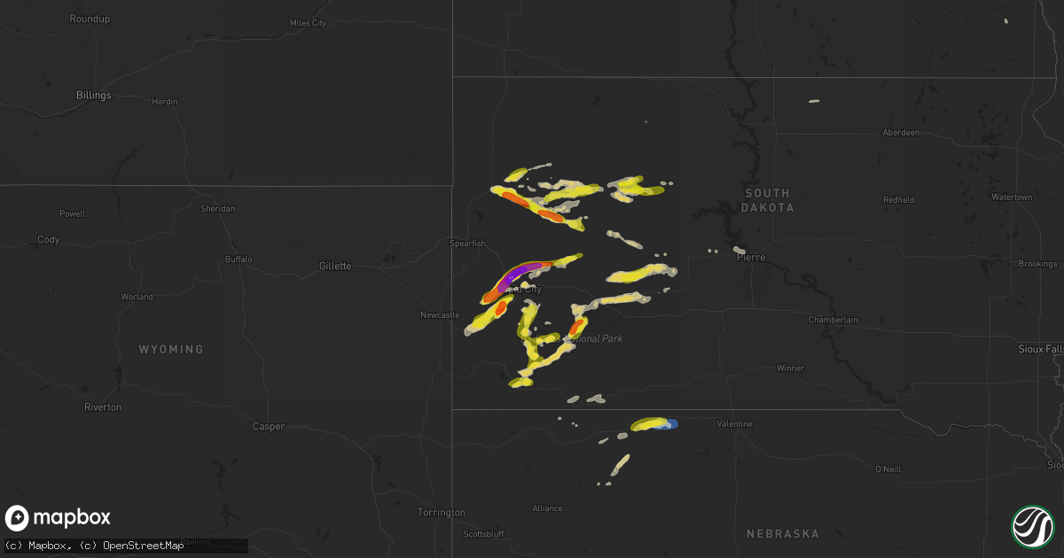
Hail Map on June 24, 2024
Get this storm
June 24 map
$229
one time, instant access
Download today. No call, no setup
Keep the $229
Bought the map and want the full workflow? Apply the entire $229 to a subscription within 7 days. None of it is wasted.
Every map, not just this one
This buys you this map. Subscription and you get every map we run, in the markets you choose from a few cities to whole states to nationwide. Plus real-time alerts the moment a storm fires.
Contact data
Name, contact info, occupancy, even credit band for addresses in the footprint. You go from where it hit to who to call.
Become the source they trust
Unlimited branding weather history reports on demand. You already have the documented answer ready for the property owner, and you are the one who showed up with it.
Property data and RoofTrace estimates
Pull up any address you have got, its value and the exact code rules for that jurisdiction, straight from One Click Code. Then RoofTrace estimates the squares, pitch, and roof value, priced the way you price.
States Impacted by Hail Map on June 24, 2024
Storm reports
North Carolina
| Date | Description |
|---|---|
| 06/24/20244:58 PM CDT | Kmrh reported a gust of 55 knots. |
| 06/24/20244:51 PM CDT | Xmac fort macon weatherflow station gusted to 57 kt. |
| 06/24/20243:30 PM CDT | A local report indicates 1.00 inch wind near 2 NNW Topsail Beach |
| 06/24/20243:22 PM CDT | Approximately 100 power outages in the bridgeton area near highway 17 per duke energy. The time was estimated based on radar data. |
| 06/24/20243:20 PM CDT | A local report indicates 1.00 inch wind near 1 SSE Hampstead |
| 06/24/20243:17 PM CDT | Large tree limb broken by thunderstorm winds on futch creek rd |
| 06/24/20243:17 PM CDT | A local report indicates 1.00 inch wind near 2 ENE Bayshore |
| 06/24/20242:58 PM CDT | Jones-onslow electric coop reports three areas of power outages... With trees and limbs blown down on powerlines between trenton and pollocksville. The time was estimat |
| 06/24/20242:14 PM CDT | Witn article of large tree which fell... That damaged a barn and vehicles in chocowinity. The time was estimated based on radar data. |
| 06/24/20241:48 PM CDT | Area of power outages noted north of kinston per duke energy. The time was estimated based on radar data. |
| 06/24/20241:31 PM CDT | Several customers without power in wanchese due to damage to power lines. Time estimated from radar. |
| 06/24/202412:47 PM CDT | Report relayed from social media. |
Minnesota
| Date | Description |
|---|---|
| 06/24/20246:24 PM CDT | Received photo of a brief tornado. Em reported no damage. |
| 06/24/20246:18 PM CDT | A local report indicates 1.75 inch wind near 9 SSW Warroad |
| 06/24/20246:00 PM CDT | A local report indicates 1.25 inch wind near 1 S Warroad |
| 06/24/20245:50 PM CDT | A local report indicates 1.00 inch wind near 3 SE Roseau |
| 06/23/202410:15 PM CDT | A local report indicates 1.75 inch wind near Bemidji |
| 06/23/202410:11 PM CDT | A local report indicates 1.25 inch wind near 2 ESE Bemidji |
| 06/23/20249:59 PM CDT | A local report indicates 1.25 inch wind near 4 N Wilton |
| 06/23/20248:24 PM CDT | Corrects previous hail report from 1 wsw red lake. |
| 06/23/20247:55 PM CDT | A local report indicates 2.75 inch wind near 3 ESE Goodridge |
| 06/23/20247:40 PM CDT | A local report indicates 1.75 inch wind near 6 NNE Mavie |
| 06/23/20247:34 PM CDT | Corrects previous hail report from 3 nw goodridge. |
Virginia
| Date | Description |
|---|---|
| 06/24/202412:10 PM CDT | Delayed report of power lines down on the 2300 block of silvertown ave. Time estimated. |
Nebraska
| Date | Description |
|---|---|
| 06/24/20246:55 PM CDT | Delayed report. |
| 06/23/20248:05 PM CDT | Received a public call of estimate 60 mph winds and pea size hail. |
| 06/23/20247:30 PM CDT | Delayed report. |
Mississippi
| Date | Description |
|---|---|
| 06/24/20242:54 PM CDT | A telephone pole was snapped along morton rankin county line road near morton... And a nearby dead tree was blown down. |
Indiana
| Date | Description |
|---|---|
| 06/24/20242:30 AM CDT | Tree snapped and downed onto a car. Time estimated from radar. |
Colorado
| Date | Description |
|---|---|
| 06/24/20242:40 PM CDT | Awos station k1mw sterling 15 wnw. |
| 06/23/20248:54 PM CDT | Mtj had a 70 mph wind gusts. Large tree limbs down. |
| 06/23/20248:49 PM CDT | Mtj reported 70 mph wind gusts. Large tree branches down. |
Utah
| Date | Description |
|---|---|
| 06/24/20243:10 PM CDT | Mesonet station utprv i-15 at provo. |
Wisconsin
| Date | Description |
|---|---|
| 06/24/20246:29 PM CDT | A local report indicates 1.00 inch wind near 1 N Viroqua |
| 06/24/20246:08 AM CDT | Photo provided on x. |
| 06/24/20245:59 AM CDT | Photo of snapped tree limbs relayed via social media. Time estimated from radar data. |
| 06/24/20245:25 AM CDT | A local report indicates 1.00 inch wind near 1 WNW West Allis |
| 06/24/20245:21 AM CDT | Time estimated from radar. Measured with ruler... Photo provided on x. |
| 06/24/20245:21 AM CDT | Measured with coin... Photo provided on x. |
| 06/24/20245:04 AM CDT | Time estimated from radar. |
| 06/24/20244:25 AM CDT | Photo of a toppled tree. Minor fence damage evident at location of fallen tree. Time estimated from radar. |
| 06/24/20244:02 AM CDT | Photo of broken tree limbs relayed via social media. Time estimated from radar. |
| 06/24/20243:59 AM CDT | Ksbm asos measurement. |
| 06/24/20243:55 AM CDT | Photo of snapped tree limbs on the north side of sheboygan. Time estimated from radar data. |
| 06/24/20243:55 AM CDT | Photo of snapped tree limb relayed by broadcast media. Time estimated from radar. |
| 06/24/20243:52 AM CDT | Via social media. Photo. |
| 06/24/20243:41 AM CDT | Multiple trees and powerlines down. Via social media. |
| 06/24/20243:40 AM CDT | Multiple trees down county-wide across manitowoc county. |
| 06/24/20243:39 AM CDT | At manitowoc airport. |
| 06/24/20243:05 AM CDT | Multiple trees down. Via social media. |
| 06/24/20243:04 AM CDT | At austin straubel international airport. |
| 06/24/20242:52 AM CDT | Near iola. Multiple trees downed. |
| 06/24/20242:42 AM CDT | Multiple trees down. Via social media. |
| 06/24/20242:34 AM CDT | Corrects previous hail report from 5 w underhill. Picture of hail at berry lake. Via social media. |
| 06/24/20242:30 AM CDT | Trees down with building damage at tigerton historical society in tigerton. Via social media. |
| 06/24/20242:29 AM CDT | At berry lake. Campers flipped... Docks missing. Downed trees all around the lake. Via social media. |
| 06/24/20242:28 AM CDT | Along legend lake. Hundreds of trees down. |
| 06/24/20242:28 AM CDT | Multiple trees snapped and broken in the keshena areas. Photos of trees onto some houses and garages and power poles knocked down. Via social media. |
| 06/24/20242:27 AM CDT | Nws damage survey confirmed tornado. An ef-1 tornado developed north of keshena along highway 55 and tracked east-southeast across the legend lake area before lifting e |
| 06/24/20242:27 AM CDT | Uprooted trees and a tree down on house along with broken power poles. Via social media. |
| 06/24/20242:20 AM CDT | Multiple trees down across rhinelander. |
| 06/24/20242:20 AM CDT | Also had 1/2 inch hail. |
| 06/24/20242:20 AM CDT | Multiple trees uprooted near big lake. |
| 06/24/20241:37 AM CDT | Trees and powerlines down. Time estimated from radar. |
| 06/24/20241:26 AM CDT | Numerous trees on powerlines led to several fires. Time estimated from radar. |
| 06/24/20241:25 AM CDT | Uprooted and snapped trees reported in medford. |
| 06/24/20241:20 AM CDT | *** 2 inj *** trees down on cabin causing the cabin to collapse. 2 injuries reported. |
| 06/24/20241:20 AM CDT | *** 2 inj *** widespread large trees uprooted and snapped along the south shore of lake nokomis. Some trees fell onto roofs and a tree fell into a cabin causing it to c |
| 06/24/20241:11 AM CDT | Corrects previous tstm wnd dmg report from 1 nne rhinelander. Multiple trees down across rhinelander. |
| 06/24/20241:00 AM CDT | Corrects previous hail report from 5 w underhill. Picture of hail at berry lake. Via social media. |
| 06/24/202412:55 AM CDT | At brown county dispatch. |
| 06/24/202412:46 AM CDT | Report from price county dispatch of numerous trees and powerlines down near phillips... With power outages. |
| 06/24/202412:43 AM CDT | Picture of hail at berry lake. Via social media. |
| 06/24/202412:35 AM CDT | Report via price county review with photo. Large trees uprooted and business sign snapped. |
| 06/24/202412:35 AM CDT | Report via price county review with photo. Metal roof partially peeled off and blown over. Time estimated from radar. |
| 06/24/202412:35 AM CDT | Report via price county review with photo. Large tree snapped in several places. |
| 06/24/202412:30 AM CDT | Measured with handheld kestrel anemometer... Confirmed by wfo. Time reported by observer. |
| 06/24/202412:30 AM CDT | Numerous trees 20 to 30 inches in diameter down. Time reported from spotter. |
| 06/24/202412:26 AM CDT | Trees uprooted. Time from observer. |
| 06/24/202412:25 AM CDT | Report via social media with photo. Time estimated from radar. Numerous trees snapped or uprooted. |
| 06/24/202412:22 AM CDT | Report via social media with photos. Numerous small to medium sized trees down. Time estimated from radar. |
| 06/23/202411:08 PM CDT | Report via social media with photo. Top two thirds of tree snapped off. Time estimated by radar. |
| 06/23/20249:24 PM CDT | Photo via social media/phone call from spotter. |
| 06/23/20247:07 PM CDT | Delayed report - 1.25 inch diameter hail reported in the village of lime ridge. |
| 06/23/20247:00 PM CDT | Relayed from broadcast media. |
Florida
| Date | Description |
|---|---|
| 06/23/20248:30 PM CDT | Alachua county so reports a road closure of sr-121... Locally nw 34th street... Near nw 5th avenue in gainesville due to a large tree being blown down from the thunders |
Iowa
| Date | Description |
|---|---|
| 06/24/20246:30 AM CDT | A local report indicates 2.00 inch wind near 4 E Maquoketa |
Illinois
| Date | Description |
|---|---|
| 06/24/20246:46 AM CDT | Estimated 60 mph along with numerous 3 inch diameter branches down in wheeling. |
| 06/24/20246:42 AM CDT | Power lines down near 498 lasher road. Time estimated from radar. |
| 06/24/20246:30 AM CDT | Time estimated from radar; small tree limbs and power lines down. |
| 06/24/20246:25 AM CDT | Numerous branches down on the 1700 block of n 1st street. Tall tree split/snapped. Tree downed onto a house in the area as well. |
| 06/24/20246:24 AM CDT | Time estimated from radar. Power lines down on hahnaman rd. |
| 06/24/20246:15 AM CDT | Trees down in memorial cemetery. Worst winds are based on viewer recollection. |
| 06/24/20245:03 AM CDT | Delayed report. Dime to quarter size hail. |
| 06/24/20244:53 AM CDT | A local report indicates 1.00 inch wind near 5 E Wellington |
| 06/24/20244:30 AM CDT | A local report indicates 1.00 inch wind near Milford |
| 06/24/20244:18 AM CDT | Photo shared of several large limbs snaped and on a house. Time estimated from radar. |
| 06/24/20244:10 AM CDT | A local report indicates 1.00 inch wind near Woodland |
| 06/24/20244:01 AM CDT | Davis weather station. |
| 06/24/20244:00 AM CDT | Tree down on a car. |
| 06/24/20243:54 AM CDT | A local report indicates 1.00 inch wind near Crescent City |
| 06/24/20243:48 AM CDT | A local report indicates 78 MPH wind near 3 SW Crescent City |
| 06/24/20243:40 AM CDT | Tree blown down across rt 49 just nw of crescent city. |
| 06/24/20242:38 AM CDT | Photo shared of corn flattered in the herscher area by wind and hail. Time estimated based on radar. |
| 06/24/20242:00 AM CDT | Photo shared of a large tree down on a house at good farm road and lincoln road in gardner. |
| 06/24/202412:45 AM CDT | Large trees down on a house in bradley. Time estimated from chat and radar. |
| 06/24/202412:09 AM CDT | Relayed via mping. |
| 06/24/202412:01 AM CDT | Quarter sized hail in plano. Relayed by em. |
Arizona
| Date | Description |
|---|---|
| 06/23/20248:45 PM CDT | Downed 12 inch tree limb. |
| 06/23/20248:33 PM CDT | Tents became airborne and large limbs fell from a tree in the center median of 107th ave. |
North Dakota
| Date | Description |
|---|---|
| 06/24/20249:00 AM CDT | A local report indicates 64 MPH wind near 1 NW Bowesmont |
California
| Date | Description |
|---|---|
| 06/23/20247:54 PM CDT | Asos located at barstow daggett airport gusted to 50 kts at 1754 due to a nearby thunderstorm. |
South Dakota
| Date | Description |
|---|---|
| 06/23/202410:45 PM CDT | A local report indicates 1.25 inch wind near 1 S Fairpoint |
| 06/23/202410:24 PM CDT | Delayed report |
| 06/23/202410:20 PM CDT | A local report indicates 1.00 inch wind near 7 SE Mud Butte |
| 06/23/20249:52 PM CDT | A few small branches down... Hail fell sideways |
| 06/23/20249:45 PM CDT | Pea to dime sized hail |
| 06/23/20249:15 PM CDT | A local report indicates 60 MPH wind near 2 N Quinn |
| 06/23/20248:50 PM CDT | A local report indicates 1.50 inch wind near 6 NE Summerset |
| 06/23/20248:46 PM CDT | Near exit 48 on i-90 |
| 06/23/20248:45 PM CDT | Time estimated via radar |
| 06/23/20248:45 PM CDT | A local report indicates 2.75 inch wind near Summerset |
| 06/23/20248:45 PM CDT | ( |
| 06/23/20248:44 PM CDT | 50 mph winds |
| 06/23/20248:40 PM CDT | A local report indicates 1.75 inch wind near Summerset |
| 06/23/20248:38 PM CDT | Golf ball to tennis ball size hail |
| 06/23/20248:30 PM CDT | Hail began at 730 and ended at 750 |
| 06/23/20248:28 PM CDT | A lot of quarter size hail with golf balls |
| 06/23/20248:20 PM CDT | A local report indicates 2.25 inch wind near 3 SSE SILVER CITY |
| 06/23/20248:20 PM CDT | A local report indicates 1.00 inch wind near 4 NNE Rockerville |
| 06/23/20248:15 PM CDT | A local report indicates 1.00 inch wind near 4 NE Rockerville |
| 06/23/20248:14 PM CDT | A local report indicates 1.25 inch wind near 1 N Mount Rushmore |
| 06/23/20247:54 PM CDT | A local report indicates 1.75 inch wind near Keystone |
| 06/23/20247:54 PM CDT | A local report indicates 1.75 inch wind near Keystone |
| 06/23/20247:51 PM CDT | Time adjusted via radar |
Michigan
| Date | Description |
|---|---|
| 06/24/20246:54 AM CDT | Scattered trees and power lines down across kalamazoo county. |
| 06/24/20246:35 AM CDT | Battle creek asos. |
| 06/24/20246:28 AM CDT | Trees and wires down across allegan county. |
| 06/24/20246:00 AM CDT | Two roofs damaged by large limbs. |
| 06/24/20245:58 AM CDT | 1 foot diameter tree and power lines down. |
| 06/24/20245:56 AM CDT | 1 foot diameter tree down on house. |
| 06/24/20245:49 AM CDT | Numerous reports of large limbs down and entire trees down along 4 mile rd in alpine township. |
| 06/24/20245:44 AM CDT | 10 to 12 inch diameter tree down in road. |
| 06/24/20245:42 AM CDT | 20 inch diameter tree on home. Time estimated from radar. |
| 06/24/20245:40 AM CDT | Large tree limbs down. |
| 06/24/20245:40 AM CDT | Tree on a house. |
| 06/24/20245:37 AM CDT | 20 inch diameter tree down on road. |
| 06/24/20245:36 AM CDT | A local report indicates 65 MPH wind near Holland NOS (State Park |
| 06/24/20245:35 AM CDT | 12 inch diameter tree down on house. |
| 06/24/20245:35 AM CDT | A local report indicates 68 MPH wind near 3 SSW Comstock Park |
| 06/24/20245:35 AM CDT | A local report indicates 68 MPH wind near 2 E Comstock Park |
| 06/24/20245:35 AM CDT | Tree landed on a shed. |
| 06/24/20245:30 AM CDT | Street light knocked over by wind. |
| 06/24/20245:28 AM CDT | Six 10 inch diameter trees blocking west bound 4 mile lane. |
| 06/24/20245:27 AM CDT | 4 mile road and peach ridge avenue two 20 inch diameter trees down. |
| 06/24/20245:20 AM CDT | Wood sided barn shifted with sections of exterior walls structurally failed and parts of metal roofing peeled. |
| 06/24/20245:08 AM CDT | Multiple trees down. |
| 06/24/20245:04 AM CDT | Muskegon asos. |
| 06/24/20245:01 AM CDT | Trees uprooted. |
| 06/24/20245:00 AM CDT | Large tree crushing a car. Damage to power pole and lines down. |
| 06/24/20245:00 AM CDT | A local report indicates 70 MPH wind near Norton Shores |
| 06/24/20244:59 AM CDT | Boat storage building roof lifted and walls collapsed. |
| 06/24/20244:58 AM CDT | Muskegon glerl. |
| 06/24/20244:55 AM CDT | About half of local roads in northern and central muskegon county impassable due to fallen trees and power lines. |
| 06/24/20244:54 AM CDT | South side of white lake. |
| 06/24/20244:54 AM CDT | Limbs snapped and trees down at pioneer county park. Trees damaged tents and camper trailers. |
| 06/24/20244:50 AM CDT | Trees uprooted with damage to a parked school bus. Tree limb snapped and fell on a pickup truck. |
| 06/24/20244:39 AM CDT | A local report indicates 68 MPH wind near 1 NW Stony Lake |
| 06/24/20244:35 AM CDT | Tree trunk fell through a premanufactured home. Snapped tree limb fell partially through a shed. |
| 06/24/20244:35 AM CDT | Tree limbs fallen and damaged camper trailer and vehicle. Other trees uprooted. Power outages in the area. |
| 06/24/20244:00 AM CDT | Large tree partially fell on house. |
| 06/24/20242:00 AM CDT | Trees down in daggett per facebook post. Later replied with a picture of the damage in the comment. Time estimated from radar. |
Cities Impacted by Hail Map on June 24, 2024
- Earleville, MD
- Portal, ND
- Flaxton, ND
- Lignite, ND
- Columbus, ND
- Sutton, ND
- Glenfield, ND
- Carrington, ND
- Murfreesboro, NC
- Ahoskie, NC
- Winton, NC
- Chesapeake, VA
- Portsmouth, VA
- Cofield, NC
- Creswell, NC
- Snow Hill, NC
- Lewiston Woodville, NC
- La Grange, NC
- Dudley, NC
- Windsor, NC
- Kinston, NC
- Greenville, NC
- Goldsboro, NC
- Grimesland, NC
- Washington, NC
- Ayden, NC
- Winterville, NC
- Stokes, NC
- Bethel, NC
- Pantego, NC
- Plymouth, NC
- Seven Springs, NC
- Belhaven, NC
- Pinetown, NC
- Mount Olive, NC
- Eglin Afb, FL
- Trenton, NC
- Dover, NC
- Jamesville, NC
- Chocowinity, NC
- Wilmington, NC
- Havelock, NC
- New Bern, NC
- Grantsboro, NC
- Hampstead, NC
- Holly Ridge, NC
- Arapahoe, NC
- Maysville, NC
- Union, MS
- Oriental, NC
- Hubert, NC
- Stella, NC
- Swansboro, NC
- Pass Christian, MS
- Gulfport, MS
- Newport, NC
- Maple Hill, NC
- Seligman, AZ
- Williams, AZ
- Claremont, MN
- Dodge Center, MN
- Byron, MN
- Atlantic Beach, NC
- Kasson, MN
- Salter Path, NC
- Emerald Isle, NC
- Rochester, MN
- Hayes Center, NE
- Rushford, MN
- Peterson, MN
- Chatfield, MN
- Caledonia, MN
- Houston, MN
- Roseau, MN
- Clarkton, NC
- Whiteville, NC
- Bladenboro, NC
- Evergreen, NC
- Salol, MN
- Warroad, MN
- Hot Springs, SD
- Oelrichs, SD
- Newfolden, MN
- Viking, MN
- Chadron, NE
- Miami, AZ
- Hokah, MN
- Smithwick, SD
- Wannaska, MN
- Hay Springs, NE
- Brownsville, MN
- Chadbourn, NC
- Cerro Gordo, NC
- Thief River Falls, MN
- Stoddard, WI
- Rushville, NE
- Middle River, MN
- Genoa, WI
- De Soto, WI
- Charleston, MS
- Pine Ridge, SD
- Ellsworth, NE
- Westby, WI
- Viroqua, WI
- Chaseburg, WI
- Kingman, AZ
- Minter City, MS
- Oral, SD
- Goodridge, MN
- Richland Center, WI
- Soldiers Grove, WI
- Blue River, WI
- Muscoda, WI
- Readstown, WI
- Ponchatoula, LA
- Viola, WI
- Springfield, LA
- Merriman, NE
- Sauk City, WI
- Hillsboro, WI
- Wonewoc, WI
- La Valle, WI
- Kelly, NC
- Atkinson, NC
- Currie, NC
- Newell, SD
- Riegelwood, NC
- Batesland, SD
- Delco, NC
- Gordon, NE
- Mazomanie, WI
- Cazenovia, WI
- Black Earth, WI
- Verona, WI
- Barneveld, WI
- Blue Mounds, WI
- Lone Rock, WI
- Plain, WI
- Hillpoint, WI
- Elroy, WI
- Mauston, WI
- Lime Ridge, WI
- Custer, SD
- Baudette, MN
- Lyndon Station, WI
- Mount Horeb, WI
- Loris, SC
- Nichols, SC
- Reedsburg, WI
- Wisconsin Dells, WI
- Albany, WI
- Belleville, WI
- Cross Plains, WI
- Loganville, WI
- Oregon, WI
- Spring Green, WI
- Hill City, SD
- Hermosa, SD
- Keystone, SD
- Arena, WI
- Lodi, WI
- Buffalo Gap, SD
- Middleton, WI
- Evansville, WI
- Brooklyn, WI
- Janesville, WI
- Brodhead, WI
- Dane, WI
- Waunakee, WI
- Rapid City, SD
- Fairburn, SD
- Clearbrook, MN
- Gonvick, MN
- Footville, WI
- Deforest, WI
- Gresham, SC
- Scenic, SD
- Cody, NE
- Belle Fourche, SD
- Redlake, MN
- Waskish, MN
- Johnsonville, SC
- Norton, KS
- Marion, SC
- Galivants Ferry, SC
- Mullins, SC
- Conway, SC
- Redby, MN
- Deadwood, SD
- Caputa, SD
- Pamplico, SC
- Long Island, KS
- Kelliher, MN
- Big Falls, MN
- Gully, MN
- Almena, KS
- Prairie View, KS
- Edgerton, WI
- Aynor, SC
- Piedmont, SD
- Black Hawk, SD
- Littlefork, MN
- Ridgeway, WI
- Madison, WI
- Phillipsburg, KS
- Puposky, MN
- Sturgis, SD
- Hines, MN
- Blackduck, MN
- Tenstrike, MN
- Wall, SD
- New Underwood, SD
- Mizpah, MN
- Northome, MN
- Hemingway, SC
- Box Elder, SD
- Union Center, SD
- Leonard, MN
- Danbury, WI
- Mud Butte, SD
- Gordon, WI
- Minong, WI
- Squaw Lake, MN
- Quinn, SD
- Shevlin, MN
- Solon Springs, WI
- Wirt, MN
- Max, MN
- Stacy, MN
- Bemidji, MN
- Philip, SD
- Kadoka, SD
- Wasta, SD
- Bigfork, MN
- Talmoon, MN
- Spring Lake, MN
- White Owl, SD
- Harris, MN
- North Branch, MN
- Enning, SD
- Orr, MN
- Hayward, WI
- Cable, WI
- Saint Croix Falls, WI
- Center City, MN
- Lindstrom, MN
- Grantsburg, WI
- Midland, SD
- Rush City, MN
- Howes, SD
- Lake Nebagamon, WI
- Brule, WI
- Drummond, WI
- Stanchfield, MN
- Cushing, WI
- Taylors Falls, MN
- Butternut, WI
- Faith, SD
- Exeland, WI
- Milesville, SD
- Spooner, WI
- Birchwood, WI
- Stone Lake, WI
- Chisago City, MN
- Wyoming, MN
- Cherry Creek, SD
- Winter, WI
- Couderay, WI
- Radisson, WI
- Trego, WI
- Luck, WI
- Frederic, WI
- Springbrook, WI
- Dupree, SD
- Hawkins, WI
- Ojibwa, WI
- Pine City, MN
- Shafer, MN
- Malta, IL
- Isabella, MN
- Park Falls, WI
- Dekalb, IL
- Minooka, IL
- Joliet, IL
- Clare, IL
- Siren, WI
- Hinckley, IL
- Prentice, WI
- Plainfield, IL
- Yorkville, IL
- Shorewood, IL
- Hayes, SD
- Phillips, WI
- Glen Flora, WI
- Glidden, WI
- Lac Du Flambeau, WI
- Kennan, WI
- Maple Park, IL
- Fort Pierre, SD
- Big Rock, IL
- Centuria, WI
- Sugar Grove, IL
- Plano, IL
- Milltown, WI
- Elburn, IL
- Wittenberg, WI
- Tigerton, WI
- Tripoli, WI
- Brantwood, WI
- Bristol, IL
- Merrill, WI
- Balsam Lake, WI
- Channahon, IL
- Elwood, IL
- Minocqua, WI
- Johnson Creek, WI
- Lake Mills, WI
- Bowler, WI
- Tomahawk, WI
- Hazelhurst, WI
- Dresser, WI
- Irma, WI
- Iron River, WI
- Woodruff, WI
- Ladysmith, WI
- Wakefield, MI
- Sandwich, IL
- Wilmington, IL
- Oswego, IL
- Jefferson, WI
- Cambridge, WI
- Fort Atkinson, WI
- Amery, WI
- Comstock, WI
- Manhattan, IL
- Peotone, IL
- Manteno, IL
- Gleason, WI
- Rhinelander, WI
- Harshaw, WI
- Rice Lake, WI
- Clintonville, WI
- Fifield, WI
- Clayton, WI
- Saint Germain, WI
- Marion, WI
- Sarona, WI
- Star Prairie, WI
- New Richmond, WI
- Deer Park, WI
- Clear Lake, WI
- Newark, IL
- Pelican Lake, WI
- Shawano, WI
- Cecil, WI
- Glenwood City, WI
- Neopit, WI
- Keshena, WI
- De Pere, WI
- Green Bay, WI
- Bruce, WI
- Shiocton, WI
- Bourbonnais, IL
- White Lake, WI
- Tony, WI
- Downing, WI
- Kankakee, IL
- Suring, WI
- Bonduel, WI
- Catawba, WI
- Boyceville, WI
- Bradley, IL
- Gillett, WI
- Ridgeland, WI
- Morris, IL
- Bonfield, IL
- Coal City, IL
- Summit Lake, WI
- Elcho, WI
- Sheldon, WI
- Conrath, WI
- New Franken, WI
- Mishicot, WI
- Denmark, WI
- Maribel, WI
- Oconto Falls, WI
- Abrams, WI
- Pulaski, WI
- Elton, WI
- Bryant, WI
- Kewaunee, WI
- Luxemburg, WI
- Lena, WI
- Coleman, WI
- Krakow, WI
- Sobieski, WI
- Suamico, WI
- Little Suamico, WI
- Mountain, WI
- Holcombe, WI
- Saint Anne, IL
- Aroma Park, IL
- Wheeler, WI
- Ogema, WI
- Momence, IL
- Gilman, WI
- Townsend, WI
- Grant Park, IL
- Colfax, WI
- Lakewood, WI
- Woodstock, IL
- Chebanse, IL
- Oconto, WI
- Pound, WI
- Westboro, WI
- Medford, WI
- Mazon, IL
- Braidwood, IL
- Bloomer, WI
- Brussels, WI
- Two Rivers, WI
- Crivitz, WI
- Peshtigo, WI
- Casco, WI
- Dunbar, WI
- Withee, WI
- Cornell, WI
- Porterfield, WI
- Jim Falls, WI
- Rib Lake, WI
- Forestville, WI
- Stetsonville, WI
- Athens, WI
- Crystal Lake, IL
- Mchenry, IL
- Algoma, WI
- Braceville, IL
- Kingsford, MI
- Iron Mountain, MI
- Niagara, WI
- Florence, WI
- Lublin, WI
- Antigo, WI
- Cadott, WI
- Deerbrook, WI
- Boyd, WI
- Stanley, WI
- Reddick, IL
- South Wilmington, IL
- Essex, IL
- Gardner, IL
- Thorp, WI
- Aniwa, WI
- Birnamwood, WI
- Sturgeon Bay, WI
- Wausau, WI
- Marinette, WI
- Buckingham, IL
- Herscher, IL
- Union Hill, IL
- Marathon, WI
- Mosinee, WI
- Eland, WI
- Hatley, WI
- Schofield, WI
- Cabery, IL
- Edgar, WI
- Unity, WI
- Spencer, WI
- Loyal, WI
- Colby, WI
- Lantry, SD
- Iola, WI
- Clifton, IL
- Junction City, WI
- Stevens Point, WI
- Stratford, WI
- Ashkum, IL
- Auburndale, WI
- Scandinavia, WI
- Marshfield, WI
- Oneida, WI
- Kaukauna, WI
- Amherst Junction, WI
- Eureka, SD
- Kempton, IL
- Martinton, IL
- Platteville, WI
- Appleton, WI
- Rewey, WI
- Milladore, WI
- Nelsonville, WI
- Waupaca, WI
- Greenleaf, WI
- Eagle Butte, SD
- Danforth, IL
- Reedsville, WI
- Gilman, IL
- Amherst, WI
- Mineral Point, WI
- Belmont, WI
- Lancaster, WI
- Potosi, WI
- Dodgeville, WI
- Ludington, MI
- Durango, IA
- Rosholt, WI
- Brillion, WI
- Crescent City, IL
- Holy Cross, IA
- Dubuque, IA
- Chilton, WI
- Hilbert, WI
- Watseka, IL
- Custer, WI
- Princeton, WI
- Markesan, WI
- Pine River, WI
- Darlington, WI
- Shelby, MI
- Pentwater, MI
- Scottville, MI
- Mears, MI
- Onarga, IL
- Epworth, IA
- Farley, IA
- Sherrill, IA
- Peosta, IA
- Berlin, WI
- Hollandale, WI
- Ripon, WI
- Green Lake, WI
- Omro, WI
- Cuba City, WI
- Hazel Green, WI
- Kieler, WI
- Forest Junction, WI
- Potter, WI
- Manistee, MI
- Worthington, IA
- Manitowoc, WI
- Valders, WI
- Kiel, WI
- Free Soil, MI
- New Era, MI
- Oshkosh, WI
- Milford, IL
- Greenville, WI
- Hart, MI
- Pickett, WI
- Montague, MI
- Marquette, WI
- Rothbury, MI
- Shullsburg, WI
- East Dubuque, IL
- Rosendale, WI
- Malone, WI
- Winneconne, WI
- Fond Du Lac, WI
- Van Dyne, WI
- Eldorado, WI
- Brandon, WI
- Walkerville, MI
- Cissna Park, IL
- Muskegon, MI
- Gratiot, WI
- Custer, MI
- Bernard, IA
- Zwingle, IA
- Mount Calvary, WI
- Plymouth, WI
- Fremont, MI
- Hesperia, MI
- Saint Cloud, WI
- Winslow, IL
- Monroe, WI
- Browntown, WI
- Spring Lake, MI
- Elkhart Lake, WI
- Grand Haven, MI
- Apple River, IL
- Bellevue, IA
- La Motte, IA
- Nunica, MI
- Fruitport, MI
- Wellington, IL
- Holton, MI
- Twin Lake, MI
- Grant, MI
- Ravenna, MI
- Oakfield, WI
- Waupun, WI
- Brownsville, WI
- Lena, IL
- Stockton, IL
- Argyle, WI
- Glenbeulah, WI
- Neosho, WI
- Oconomowoc, WI
- Juneau, WI
- Watertown, WI
- Hustisford, WI
- Orangeville, IL
- McConnell, IL
- Cascade, WI
- Campbellsport, WI
- Freeport, IL
- Waldo, WI
- Eden, WI
- Hoopeston, IL
- Ambia, IN
- Bitely, MI
- Scales Mound, IL
- Elizabeth, IL
- Galena, IL
- Holland, MI
- Mayville, WI
- West Bend, WI
- Monticello, WI
- Maquoketa, IA
- New Holstein, WI
- South Wayne, WI
- Bailey, MI
- Coopersville, MI
- Newaygo, MI
- Dakota, IL
- Casnovia, MI
- Zeeland, MI
- Hudsonville, MI
- Conklin, MI
- Sparta, MI
- Kent City, MI
- Andrew, IA
- Kewaskum, WI
- Allenton, WI
- White Cloud, MI
- Saukville, WI
- Fredonia, WI
- Howard City, MI
- Durand, IL
- Pecatonica, IL
- Rockton, IL
- Winnebago, IL
- Rockford, IL
- Monticello, IA
- Rubicon, WI
- Belgium, WI
- Fowler, IN
- Clinton, WI
- Beloit, WI
- Iron Ridge, WI
- Hartford, WI
- Whitehall, MI
- Adell, WI
- Sheboygan Falls, WI
- Lomira, WI
- Random Lake, WI
- Oostburg, WI
- Sharon, WI
- Capron, IL
- Poplar Grove, IL
- Helenville, WI
- Sullivan, WI
- Port Washington, WI
- Cedar Springs, MI
- Waukesha, WI
- Center Junction, IA
- Savanna, IL
- Sabula, IA
- Miles, IA
- Theresa, WI
- Kent, IL
- Princeton, IA
- Long Grove, IA
- Dousman, WI
- Anamosa, IA
- Harvard, IL
- Wyoming, MI
- Grandville, MI
- Byron Center, MI
- South Beloit, IL
- Caledonia, IL
- Boswell, IN
- Williamsport, IN
- Pierson, MI
- Sand Lake, MI
- Mount Carroll, IL
- Roscoe, IL
- Machesney Park, IL
- Milton, WI
- Pearl City, IL
- West Olive, MI
- Fulton, IL
- Eldridge, IA
- Grand Rapids, MI
- Attica, IN
- Hebron, IL
- Dorr, MI
- Whitewater, WI
- Morrison, IL
- Chadwick, IL
- Thomson, IL
- Lanark, IL
- Onslow, IA
- Cedar Grove, WI
- Nashotah, WI
- Okauchee, WI
- Taylor Ridge, IL
- Illinois City, IL
- Davenport, IA
- Milledgeville, IL
- Polo, IL
- Jenison, MI
- Cordova, IL
- Ridott, IL
- Ely, IA
- Wonder Lake, IL
- Shannon, IL
- Garden Prairie, IL
- Wyoming, IA
- Wales, WI
- Delafield, WI
- Marne, MI
- New Berlin, WI
- Brookfield, WI
- Mount Vernon, IA
- Sterling, IL
- Baileyville, IL
- Slinger, WI
- Cedar Rapids, IA
- Swisher, IA
- Albany, IL
- Rock Island, IL
- Andalusia, IL
- Reynolds, IL
- Milan, IL
- Ada, MI
- Ringwood, IL
- Richmond, IL
- Moline, IL
- Hartland, WI
- Mount Morris, IL
- Stanton, MI
- Trufant, MI
- Gowen, MI
- Greenville, MI
- Bettendorf, IA
- Rock City, IL
- Colgate, WI
- Palmyra, WI
- Hubertus, WI
- Belmont, MI
- Comstock Park, MI
- Belvidere, IL
- Lowell, MI
- Milo, IA
- Allendale, MI
- Wingate, IN
- Olin, IA
- Oxford Junction, IA
- Alto, MI
- Caledonia, MI
- Wayland, MI
- Camanche, IA
- Hillsdale, IL
- Erie, IL
- Clarksville, MI
- Lake Odessa, MI
- Ionia, MI
- Orleans, MI
- Middleville, MI
- Hopkins, MI
- Hastings, MI
- Shelbyville, MI
- Rockford, MI
- Hamilton, MI
- Saranac, MI
- Portland, MI
- Allegan, MI
- Freeport, MI
- Belding, MI
- Woodland, MI
- Sunfield, MI
- Vermontville, MI
- Nashville, MI
- Dowling, MI
- Martin, MI
- Delton, MI
- Plainwell, MI
- Solon, IA
- Kingston, IL
- Genoa, IL
- Harmon, IL
- Rock Falls, IL
- Dixon, IL
- Clarence, IA
- German Valley, IL
- Forreston, IL
- Leaf River, IL
- Sussex, WI
- Pewaukee, WI
- Prophetstown, IL
- Coal Valley, IL
- Oregon, IL
- Chana, IL
- Ashton, IL
- Newtown, IN
- Columbus Junction, IA
- Franklin Grove, IL
- Marengo, IL
- Saugatuck, MI
- Richfield, WI
- New Richmond, IN
- Westpoint, IN
- Veedersburg, IN
- Clinton, IA
- Blue Grass, IA
- Indianola, IA
- Battle Creek, MI
- Bellevue, MI
- Tampico, IL
- Geneseo, IL
- Roper, NC
- Rochelle, IL
- Steward, IL
- Gilberts, IL
- Huntley, IL
- Hampshire, IL
- Fennville, MI
- Pullman, MI
- Algonquin, IL
- Barrington, IL
- Otsego, MI
- Amboy, IL
- West Brooklyn, IL
- Gobles, MI
- Esmond, IL
- Crawfordsville, IN
- Teeds Grove, IA
- Lacona, IA
- Pleasantville, IA
- Osco, IL
- Orion, IL
- Colona, IL
- Dundee, IL
- Carpentersville, IL
- Elgin, IL
- Augusta, MI
- Hickory Corners, MI
- Galesburg, MI
- Climax, MI
- Richland, MI
- Delmar, IA
- Goose Lake, IA
- Bryant, IA
- Wheatland, IA
- Kalamazoo, MI
- Iowa City, IA
- Arlington Heights, IL
- Lake Zurich, IL
- Palatine, IL
- Coralville, IA
- West Branch, IA
- Bloomingdale, MI
- Lindenwood, IL
- Lowden, IA
- Grand Junction, MI
- Charlotte, IA
- Cortland, IL
- Compton, IL
- Muscatine, IA
- Lee, IL
- Walnut, IL
- De Witt, IA
- Paw Paw, IL
- South Haven, MI
- Byron, IL
- Stillman Valley, IL
- Northbrook, IL
- Wheeling, IL
- Lorimor, IA
- Spragueville, IA
- Preston, IA
- Shabbona, IL
- Hooppole, IL
- Atkinson, IL
- Buffalo Grove, IL
- Ohio, IL
- Cambridge, IL
- Waterman, IL
- Davis Junction, IL
- Lincolnshire, IL
- Mineral, IL
- Deer Grove, IL
- New Bedford, IL
- Annawan, IL
- Sheffield, IL
- Bangor, MI
- Covert, MI
- Lake Forest, IL
- Sublette, IL
- Grand Mound, IA
- Calamus, IA
- Kirkland, IL
- Carol Stream, IL
- Roselle, IL
- Bloomingdale, IL
- Saint Charles, IL
- Hanover Park, IL
- Bartlett, IL
- Wayne, IL
- Medinah, IL
- West Chicago, IL
- Lawrence, MI
- Clarinda, IA
- Bennett, IA
- Tipton, IA
- Deerfield, IL
- Highland Park, IL
- Glencoe, IL
- Schoolcraft, MI
- Aurora, IL
- Montgomery, IL
- Muskego, WI
- Big Bend, WI
- Grygla, MN
- Roosevelt, MN
- Oxford, IN
- Seymour, WI
- Mukwonago, WI
- Solway, MN