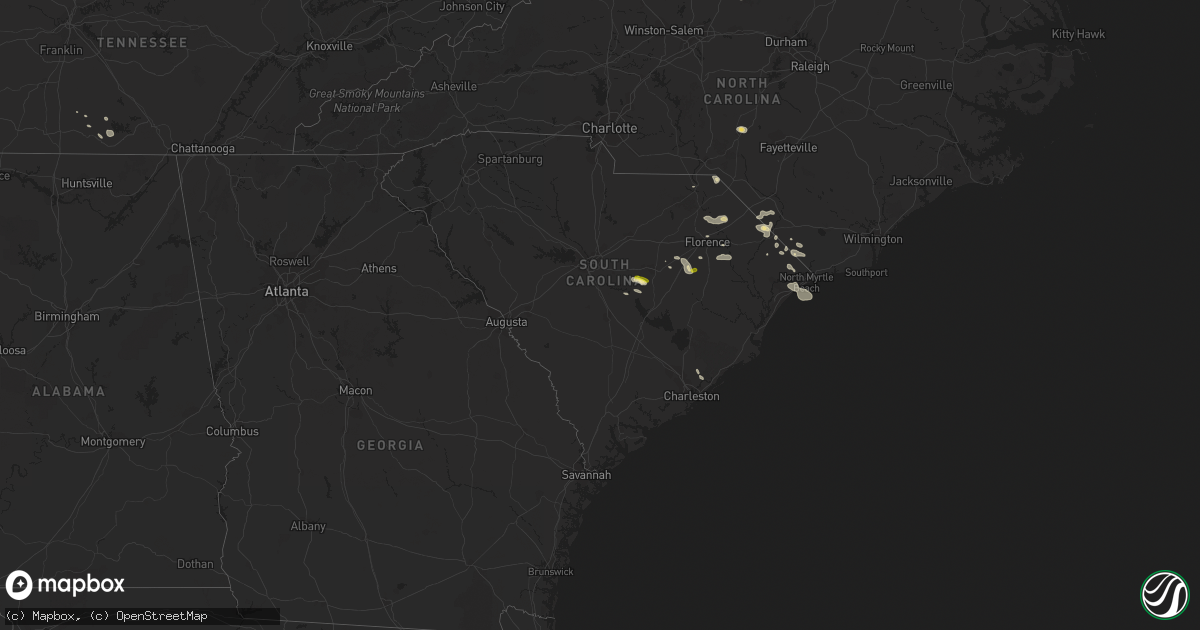
Hail Map in South Carolina on June 24, 2016
Get this storm
June 24 map
$229
one time, instant access
Download today. No call, no setup
Keep the $229
Bought the map and want the full workflow? Apply the entire $229 to a subscription within 7 days. None of it is wasted.
Every map, not just this one
This buys you this map. Subscription and you get every map we run, in the markets you choose from a few cities to whole states to nationwide. Plus real-time alerts the moment a storm fires.
Contact data
Name, contact info, occupancy, even credit band for addresses in the footprint. You go from where it hit to who to call.
Become the source they trust
Unlimited branding weather history reports on demand. You already have the documented answer ready for the property owner, and you are the one who showed up with it.
Property data and RoofTrace estimates
Pull up any address you have got, its value and the exact code rules for that jurisdiction, straight from One Click Code. Then RoofTrace estimates the squares, pitch, and roof value, priced the way you price.
Storm reports in South Carolina
South Carolina
| Date | Description |
|---|---|
| 06/24/20165:37 PM CDT | Tree down on hwy 521. |
| 06/24/20165:15 PM CDT | Law enforcement and public reports of several trees down in the vicinity of george harvin rd... Loss brook rd... And racoon rd. |
| 06/24/20164:56 PM CDT | Clarendon co 911 reports multiple trees down just outside summerton. . |
| 06/24/20164:49 PM CDT | Tree down on 62 ave in north myrtle beach. |
| 06/24/20164:43 PM CDT | Tree uprooted on sc 90. Relayed by media. |
| 06/24/20164:39 PM CDT | Trees down at crossing of old mullins hwy and sc9 |
| 06/24/20164:39 PM CDT | Tree on old mullins hwy. |
| 06/24/20164:37 PM CDT | Trees down at intersection of sc66 and holly hill rd |
| 06/24/20164:37 PM CDT | Tree down on alford rd. |
| 06/24/20164:31 PM CDT | Tree on hwy 301 and iris rd. |
| 06/24/20164:30 PM CDT | Tree down at the intersection of mckenzie and scurry rd. |
| 06/24/20164:29 PM CDT | Tree down on sc 19. |
| 06/24/20164:27 PM CDT | Schp reports trees down on interstate 95 southbound near mile markers 137-138. |
| 06/24/20164:27 PM CDT | Power lines on short cut rd. |
| 06/24/20164:14 PM CDT | Schp reports trees down at kolb rd and starks ferry rd. Time estimated based on radar. |
| 06/24/20164:10 PM CDT | Quarter size hail in olanta |
| 06/24/20164:10 PM CDT | Quarter size hail in olanta |
| 06/24/20164:07 PM CDT | Tree in roadway on hwy 403. |
| 06/24/20163:34 PM CDT | Tree down on pocket rd. |
| 06/24/20163:24 PM CDT | Tree down on pocket rd. |
| 06/24/20163:13 PM CDT | Tree on old mullins hwy. |
| 06/24/20163:11 PM CDT | Trees down at crossing of old mullins hwy and sc9 |
| 06/24/20163:08 PM CDT | Power lines down in lake view. |
All States Impacted by Hail Map on June 24, 2016
Cities Impacted by Hail Map on June 24, 2016
- Big Falls, MN
- Littlefork, MN
- Crosby, ND
- Wildrose, ND
- Alamo, ND
- Watford City, ND
- Mandaree, ND
- New Town, ND
- Parshall, ND
- Arnegard, ND
- Keene, ND
- Roseglen, ND
- Killdeer, ND
- Berlin, MD
- Pittsville, MD
- Newark, MD
- Parsonsburg, MD
- Delmar, DE
- Delmar, MD
- Willards, MD
- Pamplico, SC
- Peerless, MT
- Wheatland, WY
- Grenora, ND
- Zahl, ND
- San Patricio, NM
- Lake View, SC
- Nichols, SC
- Centralia, MO
- Vida, MT
- Culbertson, MT
- Williston, ND
- Fort Morgan, CO
- Brush, CO
- Snyder, CO
- Frazer, MT
- Winnett, MT
- Roundup, MT
- Parmelee, SD
- Fisher, WV
- Moorefield, WV
- Merriman, NE
- Bottineau, ND
- Dunseith, ND
- Taylor, ND
- Gladstone, ND
- Beulah, ND
- Alexander, ND
- Washburn, ND
- Underwood, ND
- Turtle Lake, ND
- Mercer, ND
- Lynchburg, SC
- Olanta, SC
- Hamilton, ND
- Kenmare, ND
- Wedgefield, SC
- Sumter, SC
- Pinewood, SC
- Kelliher, MN
- Goodridge, MN
- Antler, ND
- Mohall, ND
- Westhope, ND
- Maxbass, ND
- Warroad, MN
- Cohagen, MT
- Sand Springs, MT
- Jordan, MT
- Chadbourn, NC
- Clarendon, NC
- Cascade, MT
- Petersburg, WV
- Maysville, WV
- Cody, NE
- Terry, MT
- Palermo, ND
- Stanley, ND
- Poplar, MT
- Tioga, ND
- Huger, SC
- Baker, WV
- Mathias, WV
- Waverly, VA
- Lavina, MT
- Lewistown, MT
- Weskan, KS
- Grygla, MN
- Roseau, MN
- Wannaska, MN
- Petersburg, TN
- Bennettsville, SC
- Orr, MN
- Whitman, NE
- Tuthill, SD
- Ashby, NE
- Ripley, TN
- Dickinson, ND
- Green Sea, SC
- Fair Bluff, NC
- Epping, ND
- Kabetogama, MN
- Souris, ND
- Port Charlotte, FL
- Wolf Point, MT
- Darlington, SC
- Society Hill, SC
- Blenheim, SC
- Latta, SC
- Waskish, MN
- Ponemah, MN
- Columbus, ND
- Noonan, ND
- Redlake, MN
- Redby, MN
- Mosby, MT
- Grass Range, MT
- Brusett, MT
- Circle, MT
- Gormania, WV
- Mount Storm, WV
- Nashua, MT
- Berthold, ND
- Dagmar, MT
- International Falls, MN
- Hazen, ND
- Zap, ND
- Cheraw, SC
- Florence, SC
- Pembina, ND
- Froid, MT
- Middle River, MN
- Gatzke, MN
- Clearbrook, MN
- Mizpah, MN
- Brockway, MT
- Forest Grove, MT
- Ray, ND
- Lancaster, MN
- Loris, SC
- Tabor City, NC
- Ryegate, MT
- Eads, CO
- Arcadia, FL
- Southern Pines, NC
- Vass, NC
- Carthage, NC
- Pinehurst, NC
- Judith Gap, MT
- Larslan, MT
- Fork, SC
- Fairmont, NC
- Lynchburg, TN
- Anamoose, ND
- Jackson, TN
- Medina, TN
- Belfield, ND
- Georgetown, DE
- Millsboro, DE
- Saint John, ND
- McColl, SC
- Esmond, ND
- York, ND
- Longs, SC
- Conway, SC
- Dunn Center, ND
- Langdon, ND
- Minden, NE
- Humboldt, TN
- Gadsden, TN
- Yanceyville, NC
- Cabins, WV
- Blackduck, MN
- Northome, MN
- Crane Lake, MN
- Bathgate, ND
- Cavalier, ND
- Myrtle Beach, SC
- Medicine Lake, MT
- Bowling Green, FL
- Drummond, MT
- Wolf Creek, MT
- Helena, MT
- Heartwell, NE
- Fulks Run, VA
- Broadway, VA
- Bergton, VA
- Dagsboro, DE
- Laurel, DE
- Frankford, DE
- Keyser, WV
- Oakland, MD
- Mcclusky, ND
- Whitetail, MT
- Scobey, MT
- Saint Matthews, SC
- Brownsville, TN
- Fallon, MT
- Lindsay, MT
- Miles City, MT
- Effingham, SC
- Timmonsville, SC
- Mount Vernon, AR
- Leeds, ND
- Carpenter, WY
- Cartwright, ND
- Belvidere, TN
- Plaza, ND
- Makoti, ND
- Vail, AZ
- Charleston, SC
- Dillon, SC
- Orrum, NC
- Galivants Ferry, SC
- Winston, MT
- Fortuna, ND
- Ambrose, ND
- Hebron, ND
- Turbeville, SC
- Glendive, MT
- Romance, AR
- Bloomfield, MT
- Richey, MT
- Calhan, CO
- Goodland, KS
- Myakka City, FL
- Parrish, FL
- Richardton, ND
- East Helena, MT
- Rose Bud, AR
- Sheridan Lake, CO
- Red Cloud, NE
- Stanton, ND
- New Salem, ND
- Willow City, ND
- Bowbells, ND
- Belfast, TN
- Kelso, TN
- Mulberry, TN
- Fayetteville, TN
- Rugby, ND
- Savage, MT
- Sidney, MT
- Crane, MT
- Winchester, TN
- Whiteville, NC
- Mayesville, SC
- Scranton, SC
- Lake City, SC
- Ingomar, MT
- Whaleyville, MD


