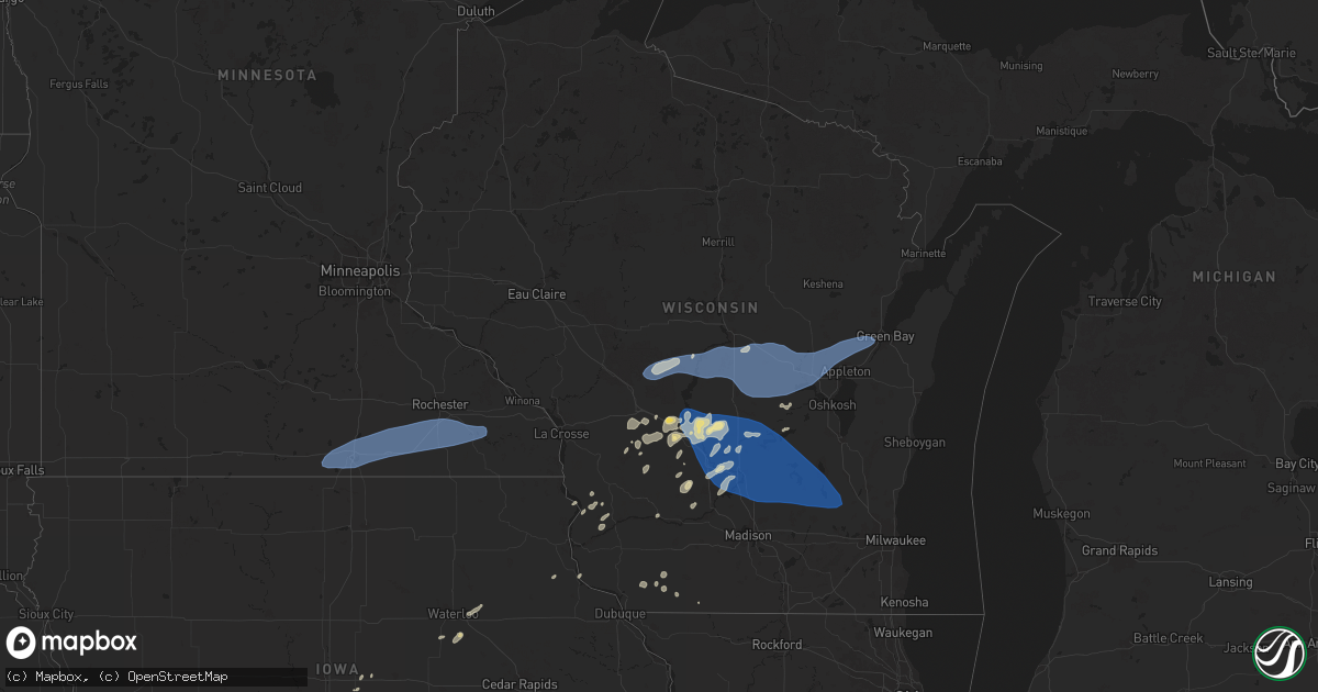
Hail Map in Wisconsin on June 23, 2025
Get this storm
June 23 map
$229
one time, instant access
Download today. No call, no setup
Keep the $229
Bought the map and want the full workflow? Apply the entire $229 to a subscription within 7 days. None of it is wasted.
Every map, not just this one
This buys you this map. Subscription and you get every map we run, in the markets you choose from a few cities to whole states to nationwide. Plus real-time alerts the moment a storm fires.
Contact data
Name, contact info, occupancy, even credit band for addresses in the footprint. You go from where it hit to who to call.
Become the source they trust
Unlimited branding weather history reports on demand. You already have the documented answer ready for the property owner, and you are the one who showed up with it.
Property data and RoofTrace estimates
Pull up any address you have got, its value and the exact code rules for that jurisdiction, straight from One Click Code. Then RoofTrace estimates the squares, pitch, and roof value, priced the way you price.
Storm reports in Wisconsin
Wisconsin
| Date | Description |
|---|---|
| 06/23/20256:50 PM CDT | Law enforcement reported at least 6 trees down across the oshkosh area. One tree downed onto a telephone wire. Time and location estimated from radar. |
| 06/23/20256:43 PM CDT | Power pole and lines downed. Several large tree branches downed. |
| 06/23/20256:38 PM CDT | Several trees and limbs down... One uprooted. |
| 06/23/20256:35 PM CDT | Several trees and limbs downed between lamartine and oakfield. |
| 06/23/20256:25 PM CDT | Trees uprooted in waupun |
| 06/23/20256:25 PM CDT | Trees uprooted in waupun. |
| 06/23/20256:22 PM CDT | Multiple large branches and some trees down. |
| 06/23/20256:00 PM CDT | Scattered trees downed throughout the county. |
| 06/23/20255:50 PM CDT | A local report indicates 69 MPH wind near 3 W Poynette |
| 06/23/20255:45 PM CDT | Numerous reports of trees down throughout the county. |
| 06/23/20255:40 PM CDT | Tree down. |
| 06/23/20255:36 PM CDT | Large tree blocking the road on county cc and 4th avenue. Time estimated by radar. |
| 06/23/20255:35 PM CDT | Dispatch reports numerous trees down through the county. |
| 06/23/20255:30 PM CDT | Dispatch reports numerous trees down scattered across the county. |
| 06/23/20255:27 PM CDT | Large tree branch over road. |
| 06/23/20255:17 PM CDT | Tree down in city. |
| 06/23/20255:05 PM CDT | Boats and big pine tree blown over. |
| 06/23/20254:55 PM CDT | Reports of tree fallen on a vehicle. |
| 06/23/20253:35 PM CDT | Traffic light down near bridge downtown... Blocking traffic. Time estimated via radar. |
| 06/23/20253:32 PM CDT | *** 1 fatal *** severe thunderstorm winds caused a tree to fall onto a person. The person was taken to the hospital and passed away from the injuries. Delayed report. T |
| 06/23/20253:32 PM CDT | Several trees reported down across the east side of green bay... Including one on a car. No injuries reported. Time estimated via radar. |
| 06/23/20253:29 PM CDT | 58 mph measured by the green bay airport asos. |
| 06/23/20253:15 PM CDT | Tree reported down over roadway. Time estimated via radar. |
| 06/23/20252:56 PM CDT | Large pine tree uprooted. Photo via social media... Time estimated from radar. |
| 06/23/20252:32 PM CDT | 2 trees down. Time estimated via radar. |
| 06/23/20252:27 PM CDT | Several reports of trees down across roadways in the northwest part of waushara county. These reports were from n of hancock to just w of saxeville. Time of specific ls |
| 06/23/20252:25 PM CDT | Trees down near hwy 73 and mm northwest of wautoma. Time estimated by radar. |
| 06/23/20252:20 PM CDT | Report via local media. Semi overturned traveling east on us hwy 10 near amherst junction. Time estimated. |
| 06/23/20252:16 PM CDT | Line of power lines down... All splintered at the base. Time estimated from radar. |
| 06/23/20251:51 PM CDT | Gust to 69 mph at isw asos. |
| 06/23/20251:50 PM CDT | Photos of tree trunk and large branch snapped via social media. |
| 06/23/20251:50 PM CDT | Report from public via local media. Located in grand rapids... On south side of wisconsin rapids. 3 big trees down. Time estimated. |
| 06/23/20251:46 PM CDT | Gust to 62 mph at isw asos. |
| 06/23/20251:45 PM CDT | Report from public via local media. Downed tree on a power line. |
| 06/23/20251:19 PM CDT | A local report indicates 59 MPH wind near 6 W Babcock |
| 06/22/20257:12 PM CDT | Several trees down between plymouth and random lake and across western portions of sheboygan county. |
All States Impacted by Hail Map on June 23, 2025
Cities Impacted by Hail Map on June 23, 2025
- Pittsville, WI
- Warrens, WI
- Babcock, WI
- Lexington, TN
- Wisconsin Rapids, WI
- Cedar Grove, TN
- Necedah, WI
- Nekoosa, WI
- Port Edwards, WI
- Bancroft, WI
- Plainfield, WI
- Plover, WI
- Stevens Point, WI
- Elrod, AL
- Echola, AL
- Gordo, AL
- Almond, WI
- Alden, MN
- Conger, MN
- Albert Lea, MN
- Austin, MN
- Blooming Prairie, MN
- Hollandale, MN
- Clarks Grove, MN
- Hayward, MN
- Glenville, MN
- Twin Lakes, MN
- Lansing, MN
- Waltham, MN
- Wells, MN
- Stewartville, MN
- Kasson, MN
- Brownsdale, MN
- Sargeant, MN
- Rochester, MN
- Grand Meadow, MN
- Byron, MN
- Hayfield, MN
- Dexter, MN
- Racine, MN
- Rose Creek, MN
- Spring Valley, MN
- Pass Christian, MS
- Kiln, MS
- Amherst, WI
- Custer, WI
- Scandinavia, WI
- Amherst Junction, WI
- Waupaca, WI
- Wild Rose, WI
- Wautoma, WI
- Hancock, WI
- Ponchatoula, LA
- Ogdensburg, WI
- Manawa, WI
- Weyauwega, WI
- Pine River, WI
- New London, WI
- Poy Sippi, WI
- Fremont, WI
- Redgranite, WI
- Berlin, WI
- Balmorhea, TX
- Kennedy, AL
- Millport, AL
- Larsen, WI
- Winneconne, WI
- Hortonville, WI
- Shiocton, WI
- Northport, AL
- Appleton, WI
- Neenah, WI
- Greenville, WI
- Black Creek, WI
- Kaukauna, WI
- Seymour, WI
- De Pere, WI
- Mayhill, NM
- Newberry, MI
- Tinnie, NM
- Grand Marais, MI
- Courtland, KS
- Webber, KS
- Vernon, AL
- Sierra Blanca, TX
- Oneida, WI
- Sulligent, AL
- Capitan, NM
- Maxwell, NM
- Puryear, TN
- Paris, TN
- Belleville, KS
- Republic, KS
- Raton, NM
- Crab Orchard, NE
- Lyons, KS
- Raymond, KS
- Essex, IA
- Norwalk, WI
- Wilton, WI
- Cottage Grove, TN
- Junction City, KS
- Chapman, KS
- Green Bay, WI
- Wykoff, MN
- Chatfield, MN
- Fountain, MN
- Utica, MN
- Lanesboro, MN
- Saint Charles, MN
- Hope, NM
- Tecumseh, NE
- Clarinda, IA
- Tomah, WI
- Burchard, NE
- Lewiston, NE
- Corona, NM
- Randall, KS
- Jewell, KS
- Chase, KS
- Villisca, IA
- Stanton, IA
- Red Oak, IA
- Cleveland, TX
- Shenandoah, IA
- La Farge, WI
- Cimarron, KS
- Rock Port, MO
- Claude, TX
- Hockley, TX
- Canadian, TX
- Milford, KS
- Viola, KS
- Ontario, WI
- Kendall, WI
- Santa Rosa, NM
- Hamburg, IA
- Sidney, IA
- Camp Douglas, WI
- New Lisbon, WI
- Elroy, WI
- Elliott, IA
- Corning, IA
- Grenville, NM
- Des Moines, NM
- Little River, KS
- Hamilton, AL
- Giltner, NE
- Greenwood Springs, MS
- Tremont, MS
- Jetmore, KS
- Mauston, WI
- Perryton, TX
- Smithville, MS
- Philadelphia, MS
- Riley, KS
- Soldiers Grove, WI
- Ferryville, WI
- Lansing, IA
- Cumberland, IA
- Eastman, WI
- Fort Riley, KS
- Griswold, IA
- Miami, TX
- Plains, KS
- Forgan, OK
- Fulton, MS
- Hillsboro, WI
- Windom, KS
- Great Bend, KS
- Gays Mills, WI
- Russellville, AL
- Paradise, MI
- Virginia, NE
- Blue Springs, NE
- Liberty, NE
- Nebraska City, NE
- Ogden, KS
- Manhattan, KS
- Folsom, NM
- Lillian, AL
- Collins, IA
- Hampton, NE
- Henderson, NE
- Aurora, NE
- Lyndon Station, WI
- Elberta, AL
- Adams, WI
- Atlantic, IA
- Mcpherson, KS
- Hastings, IA
- Malvern, IA
- Randolph, IA
- Tabor, IA
- Friendship, WI
- Seminole, AL
- Peru, NE
- La Valle, WI
- Larned, KS
- Maxwell, IA
- Steuben, WI
- Meade, KS
- Wisconsin Dells, WI
- Bremen, KS
- Marysville, KS
- Grand Marsh, WI
- Eckerman, MI
- Tampa, KS
- Durham, KS
- Marion, KS
- Fowler, KS
- Home, KS
- Steinauer, NE
- Baraboo, WI
- Garfield, KS
- Waterville, KS
- Hanover, KS
- Robertsdale, AL
- Norwalk, IA
- Oxford, WI
- Cumming, IA
- West Des Moines, IA
- Des Moines, IA
- Pleasant Hill, IA
- Altoona, IA
- State Center, IA
- Briggsville, WI
- Boscobel, WI
- Reedsburg, WI
- Loganville, WI
- Rock Springs, WI
- Merrimac, WI
- Wauzeka, WI
- Lodi, WI
- Prairie Du Sac, WI
- Mitchellville, IA
- Cedar Key, FL
- Ramona, KS
- Hope, KS
- Coin, IA
- Bondurant, IA
- Clearfield, IA
- Endeavor, WI
- Portage, WI
- Ensign, KS
- Dodge City, KS
- Old Town, FL
- Montello, WI
- Northboro, IA
- Cuervo, NM
- Council Grove, KS
- Allen, KS
- Alta Vista, KS
- Sauk City, WI
- Georgetown, MS
- Harrisville, MS
- Dawson, NE
- Stella, NE
- Humboldt, NE
- Claflin, KS
- Hoisington, KS
- Westfield, WI
- Lone Rock, WI
- Mosquero, NM
- Wright, KS
- Prairie City, IA
- Monroe, IA
- Petal, MS
- La Porte City, IA
- Rush Center, KS
- Alma, KS
- Burlington Junction, MO
- Tarkio, MO
- Elmo, MO
- Bison, KS
- Hattiesburg, MS
- Colo, IA
- Minburn, IA
- Otis, KS
- Imogene, IA
- Farragut, IA
- Woodward, IA
- Geneseo, KS
- Beatrice, NE
- Bouton, IA
- Burdett, KS
- Lewis, IA
- Dallas Center, IA
- Granger, IA
- Pleasureville, KY
- Tampa, FL
- Green Lake, WI
- Perry, IA
- Adel, IA
- New Port Richey, FL
- Grant, IA
- Wiota, IA
- Loxley, AL
- Rozel, KS
- Guthrie Center, IA
- Panora, IA
- Yale, IA
- Spring Green, WI
- Kinsley, KS
- Liberty, MS
- Russell, KS
- Bear Creek, AL
- Maryville, MO
- Ravenwood, MO
- Parnell, MO
- Hopkins, MO
- Garden City, KS
- Jesup, IA
- Palm Harbor, FL
- Waterloo, IA
- Dunkerton, IA
- Tarpon Springs, FL
- Buckingham, IA
- Arlington, WI
- Dane, WI
- Pardeeville, WI
- Poynette, WI
- Rio, WI
- Fall River, WI
- Wyocena, WI
- Doylestown, WI
- Cambria, WI
- Columbus, WI
- Texhoma, OK
- Pacific Junction, IA
- Glenwood, IA
- Goodwell, OK
- Cassville, WI
- Brewton, AL
- Kenton, OK
- Clayton, NM
- Crystal Beach, FL
- Holiday, FL
- Lena, MS
- Elkport, IA
- Clyde, KS
- Aurora, KS
- Camden, MS
- Daphne, AL
- Boise City, OK
- Randolph, WI
- Markesan, WI
- Packwaukee, WI
- Neshkoro, WI
- Dalton, WI
- Princeton, WI
- Marquette, WI
- Reeseville, WI
- Beaver Dam, WI
- Friesland, WI
- Kingston, WI
- Watertown, WI
- Lowell, WI
- Fox Lake, WI
- Juneau, WI
- Clyman, WI
- Hustisford, WI
- Burnett, WI
- Waupun, WI
- Neosho, WI
- Iron Ridge, WI
- Horicon, WI
- Rubicon, WI
- Mayville, WI
- Hartford, WI
- Perryville, MD
- Utica, MS
- Sully, IA
- Reasnor, IA
- Hudson, IA
- Atlantic City, NJ
- Monticello, MS
- Silver Creek, MS
- Pritchett, CO
- Fairbank, IA
- Oak Vale, MS
- Brandon, MS
- Satsuma, AL
- Fairfax, MO
- Texline, TX
- Lenox, AL
- Repton, AL
- Elkhart, KS
- Madison, MS
- Canton, MS
- Ventnor City, NJ
- Sedan, NM
- Clearwater Beach, FL
- Brookhaven, MS
- Concordia, KS
- Lucas, KS
- Campo, CO
- Baltimore, MD
- Blanchard, IA
- Chiefland, FL
- Havre De Grace, MD
- Aberdeen, MD
- Ulysses, KS
- Natchez, MS
- Pella, IA
- Brooklyn, MD
- Diagonal, IA
- Halethorpe, MD
- Curtis Bay, MD
- Aberdeen Proving Ground, MD
- Port Deposit, MD
- North East, MD
- Franklin, AL
- Vredenburgh, AL
- Elkton, MD
- Keyes, OK
- Platteville, WI
- Coatesville, PA
- Union Church, MS
- Newark, DE
- Ferriday, LA
- Vidalia, LA
- Gap, PA
- Parkesburg, PA
- Honey Brook, PA
- Bedford, IA
- Pickering, MO
- Parkville, MD
- Nottingham, MD
- Dundalk, MD
- Belmont, WI
- Atmore, AL
- Darlington, WI
- Shullsburg, WI
- Abingdon, MD
- Savannah, MO
- Saint Joseph, MO
- Vicksburg, MS
- Bel Air, MD
- Joppa, MD
- Mineral Point, WI
- Rosedale, MD
- Kingsville, MD
- Edgewood, MD
- Belcamp, MD
- Upper Falls, MD
- White Marsh, MD
- Perry Hall, MD
- Wesson, MS
- South Wayne, WI
- Gratiot, WI
- Hanston, KS
- Edwards, MS
- Annapolis, MD
- Middle River, MD
- Essex, MD
- Newark, MD
- Saint Georges, DE
- New Castle, DE
- Bear, DE
- Wilmington, DE
- Philadelphia, PA
- Cape May, NJ
- Hockessin, DE
- Clayton, DE
- Townsend, DE
- Rockland, DE
- Montchanin, DE
- Greenwich, NJ
- Middletown, DE
- Arlington, VA
- Mesilla Park, NM
- Las Cruces, NM
- Yorklyn, DE
- Sparrows Point, MD
- Quitman, MS
- Glen Burnie, MD
- Ocean City, MD
- Villas, NJ
- Dagsboro, DE
- Frankford, DE
- Cloudcroft, NM
- Tracys Landing, MD
- Kennedyville, MD
- Chestertown, MD
- Stevensville, MD
- Earleville, MD
- Port Republic, MD
- Prince Frederick, MD
- Friendship, MD
- Saint Michaels, MD
- Easton, MD
- Bozman, MD
- Worton, MD
- Chesapeake City, MD
- Huntingtown, MD
- Galena, MD
- Chesapeake Beach, MD
- Owings, MD
- Centreville, MD
- Millington, MD
- Chester, MD
- Odessa, DE
- Smyrna, DE
- Cordova, MD
- Queenstown, MD
- Wye Mills, MD
- Queen Anne, MD
- Patuxent River, MD
- Lexington Park, MD
- Saint Leonard, MD
- Sunderland, MD
- Lothian, MD
- Dunkirk, MD
- North Beach, MD
- Deale, MD
- Churchton, MD
- West River, MD
- Narberth, PA
- Margate City, NJ
- Hillsboro, MD
- Ridgely, MD
- Denton, MD
- Edgewater, MD
- California, MD
- Hollywood, MD
- Ardmore, PA
- Havertown, PA
- Longport, NJ
- Mechanicsville, MD
- Port Norris, NJ
- Lansdowne, PA
- Cheltenham, PA
- Elkins Park, PA
- Vienna, VA
- Union Star, MO
- Bala Cynwyd, PA
- Leesburg, NJ
- Dunn Loring, VA
- Woodlyn, PA
- Crum Lynne, PA
- Chester, PA
- Marcus Hook, PA
- Woodbine, NJ
- Harwood, MD
- Galesville, MD
- Upper Darby, PA
- Wynnewood, PA
- Brookhaven, PA
- Wallingford, PA
- Folsom, PA
- Swarthmore, PA
- Ridley Park, PA
- Morton, PA
- Drexel Hill, PA
- Springfield, PA
- Clifton Heights, PA
- Merion Station, PA
- Hughesville, MD
- Dameron, MD
- Falls Church, VA
- Fairfax, VA
- McLean, VA
- Wildwood, NJ
- Millville, NJ
- Claymont, DE
- Henderson, MD
- Goldsboro, MD
- Paulsboro, NJ
- Greensboro, MD
- Darby, PA
- Sharon Hill, PA
- Heislerville, NJ
- Delmont, NJ
- Annandale, VA
- King George, VA
- Folcroft, PA
- Prospect Park, PA
- Norwood, PA
- Glenolden, PA
- Essington, PA
- Camden, NJ
- Holmes, PA
- Swedesboro, NJ
- Woodstown, NJ
- Washington, DC
- Hyattsville, MD
- Silver Spring, MD
- Scotland, MD
- Chevy Chase, MD
- Bethesda, MD
- Church Hill, MD
- Takoma Park, MD
- Gloucester City, NJ
- Westville, NJ
- Beltsville, MD
- Lumberton, NJ
- Vincentown, NJ
- Medford, NJ
- Gibson Island, MD
- Pennsville, NJ
- Berlin, NJ
- Sicklerville, NJ
- Pedricktown, NJ
- Reston, VA
- Bowie, MD
- Arnold, MD
- Pasadena, MD
- Gibbstown, NJ
- Fort Myer, VA
- Alexandria, VA
- Laurel, MD
- Rising Sun, MD
- Mullica Hill, NJ
- Pennsauken, NJ
- Monroeville, NJ
- Elmer, NJ
- Bridgeport, NJ
- Bellmawr, NJ
- Penns Grove, NJ
- Fort George G Meade, MD
- Perry Point, MD
- District Heights, MD
- Upper Marlboro, MD
- Capitol Heights, MD
- Dorchester, NJ
- Mauricetown, NJ
- Columbia, MD
- Jessup, MD
- Savage, MD
- Williamstown, NJ
- Mount Holly, NJ
- Delaware City, DE
- Herndon, VA
- Davidsonville, MD
- Gambrills, MD
- Rockville, MD
- Crownsville, MD
- Burtonsville, MD
- Cape May Point, NJ
- Millersville, MD
- Franklinville, NJ
- Newfield, NJ
- Malaga, NJ
- Kensington, MD
- Clayton, NJ
- West Berlin, NJ
- Clementon, NJ
- Voorhees, NJ
- College Park, MD
- Warwick, MD
- Severna Park, MD
- Odenton, MD
- Aston, PA
- Severn, MD
- Hanover, MD
- Ridge, MD
- Salem, NJ
- Vineland, NJ
- Bridgeton, NJ
- Annapolis Junction, MD
- Alloway, NJ
- King City, MO
- Oakton, VA
- Landisville, NJ
- Minotola, NJ
- Rea, MO
- Mays Landing, NJ
- Buena, NJ
- Hammonton, NJ
- Newtonville, NJ
- Port Penn, DE
- Agency, MO
- Amity, MO
- Helena, MO
- Maysville, MO
- Fallston, MD
- Broad Run, VA
- Haymarket, VA
- Norfolk, VA
- Glassboro, NJ
- Egg Harbor Township, NJ
- Gunpowder, MD
- Manahawkin, NJ
- Temple Hills, MD
- Warrenton, VA
- Forest Hill, MD
- Springfield, VA
- Suitland, MD
- Tuckerton, NJ
- Northfield, NJ
- Dorothy, NJ
- Milmay, NJ
- Estell Manor, NJ
- Fort Howard, MD
- Pleasantville, NJ
- Newport, NJ
- Beach Haven, NJ
- Catonsville, MD
- Rock Hall, MD
- Fort Washington, MD
- Andrews Air Force Base, MD
- White Stone, VA
- Georgetown, MD
- Still Pond, MD
- Cedarville, NJ
- Absecon, NJ
- Egg Harbor City, NJ
- Clarksville, MD
- Ellicott City, MD
- Elkridge, MD
- Fulton, MD
- Harmans, MD
- Clinton, MD
- Ocean City, NJ
- Shady Side, MD
- West Creek, NJ
- Charlotte Hall, MD
- Aquasco, MD
- Brandywine, MD
- Massey, MD
- Marmora, NJ
- Linthicum Heights, MD
- Inman, KS
- Lusby, MD
- Somers Point, NJ
- Crapo, MD
- Toddville, MD
- Wingate, MD
- Gladwyne, PA
- Burgess, VA
- Heathsville, VA
- Colonial Beach, VA
- Saluda, VA
- Shacklefords, VA
- Reedville, VA
- Barnegat, NJ
- Park Hall, MD
- Saint Inigoes, MD
- Sudlersville, MD
- Gloucester, VA
- Westover, MD
- Princess Anne, MD
- Hampton, VA
- Rhodesdale, MD
- East New Market, MD
- Seaford, VA
- Yorktown, VA
- Chatsworth, NJ
- Deal Island, MD
- Kilmarnock, VA
- Mathews, VA
- Hudgins, VA
- Cobbs Creek, VA
- Chincoteague Island, VA
- Pocomoke City, MD
- Hartly, DE
- Marydel, DE
- Vienna, MD
- Marydel, MD
- Barclay, MD
- Diggs, VA
- Onemo, VA
- Moon, VA
- Riva, MD
- Mardela Springs, MD
- Hurlock, MD
- Laurel, DE
- Delmar, DE
- Seaford, DE
- Federalsburg, MD
- Preston, MD
- Arkdale, WI
- Elkton, MN
- Cosby, MO
- Clarksdale, MO
- Easton, MO
- Stewartsville, MO
- Gower, MO
- Osborn, MO
- Plattsburg, MO
- Cameron, MO
- Weatherby, MO
- Winston, MO
- Pattonsburg, MO
- Stapleton, AL
- Bay Minette, AL
- Hurlburt Field, FL
- Fort Walton Beach, FL
- Mary Esther, FL
- Eglin Afb, FL
- Navarre, FL
- Milton, FL
- Gulf Breeze, FL


