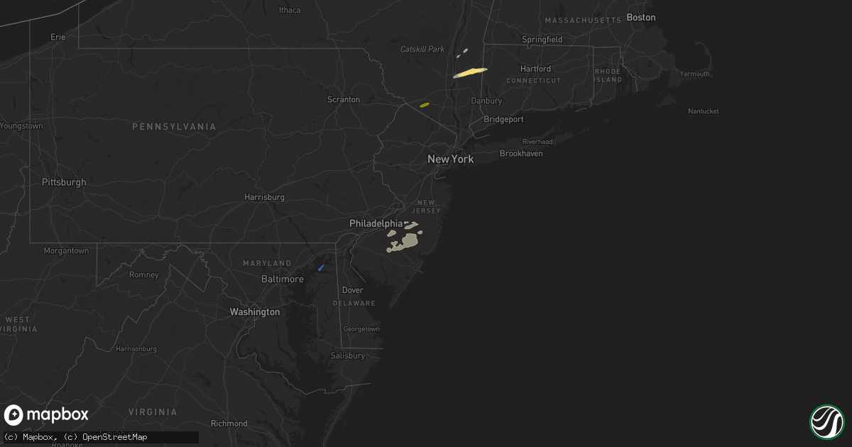
Hail Map in New Jersey on June 23, 2024
Get this storm
June 23 map
$229
one time, instant access
Download today. No call, no setup
Keep the $229
Bought the map and want the full workflow? Apply the entire $229 to a subscription within 7 days. None of it is wasted.
Every map, not just this one
This buys you this map. Subscription and you get every map we run, in the markets you choose from a few cities to whole states to nationwide. Plus real-time alerts the moment a storm fires.
Contact data
Name, contact info, occupancy, even credit band for addresses in the footprint. You go from where it hit to who to call.
Become the source they trust
Unlimited branding weather history reports on demand. You already have the documented answer ready for the property owner, and you are the one who showed up with it.
Property data and RoofTrace estimates
Pull up any address you have got, its value and the exact code rules for that jurisdiction, straight from One Click Code. Then RoofTrace estimates the squares, pitch, and roof value, priced the way you price.
Storm reports in New Jersey
New Jersey
| Date | Description |
|---|---|
| 06/23/20246:39 PM CDT | Report of wires down along route 563 in washington township... Nj. |
| 06/23/20246:14 PM CDT | Several trees down in beachwood. Time estimated from radar. |
| 06/23/20246:10 PM CDT | Downed tree on nj 166 southbound north of cr 530/cr 527/cr 549 in toms river twp. There is a lane closure. Time estimated from radar. |
| 06/23/20246:03 PM CDT | Video sent in of large branches down on wires... With wires on fire. Time estimated from radar. |
| 06/23/20245:43 PM CDT | Trained spotter trees down around pitman. Time estimated from radar. |
| 06/23/20245:43 PM CDT | Tree snapped and lying across the road at intersection of cedar ave and holly ave. Time estimated. |
| 06/23/20245:41 PM CDT | Numerous large downed branches on the shoulder of cr530. |
| 06/23/20245:40 PM CDT | Report from mping: 1-inch tree limbs broken; shingles blown off. |
| 06/23/20245:34 PM CDT | Report from mping: 1-inch tree limbs broken; shingles blown off. Time adjusted based on radar data. |
| 06/23/20245:26 PM CDT | Pictures sent in of trees down on a house in woodstown... Causing damage to the roof. Time estimated from radar. |
| 06/23/20245:26 PM CDT | Large tree down across a road in woodstown. Time estimated. |
| 06/23/20245:25 PM CDT | Several trees down in pilesgrove... Nj. Time estimated from radar. |
| 06/23/20245:21 PM CDT | Report from mping: 3-inch tree limbs broken; power poles broken. |
| 06/23/20245:20 PM CDT | Multiple trees and large branches down. Biggest was at intersection of cooper st and melrose ave. |
| 06/23/20245:16 PM CDT | Video of trees down along church road in mount laurel. The left lane was closed. Time estimated from radar. |
| 06/23/20245:15 PM CDT | Large tree down across a fence. Time estimated from radar. |
| 06/23/20245:12 PM CDT | Report of wires down in willingboro near veterans parkway. |
| 06/23/20245:10 PM CDT | Picture of large tree down on the nj turnpike near mile marker 37. Time estimated from radar. |
| 06/23/20245:10 PM CDT | Picture showed a large tree uprooted and onto a house on highland avenue in moorestown. Time estimated from radar. |
| 06/23/20245:10 PM CDT | Picture showed a couple of large trees uprooted in the strawbridge lake section in moorestown. Time estimated from radar. |
| 06/23/20245:07 PM CDT | Numerous trees down... Lines down and a picture of a gazebo collapsed in delanco. Time estimated from radar. |
| 06/23/20245:06 PM CDT | Reports of trees down along the delaware river in delanco. Time estimated from radar. |
| 06/23/20244:55 PM CDT | Large tree down on south bellmawr ave. Time estimated. |
| 06/23/20244:55 PM CDT | Nj turnpike auth.: downed tree on new jersey turnpike northbound north of interchange 2 - us 322 |
| 06/22/20249:37 PM CDT | Report of tree damage around lacey township/forked river with power outages. Time estimated from radar. |
| 06/22/20247:47 PM CDT | Report from mping: 1-inch tree limbs broken; shingles blown off. |
All States Impacted by Hail Map on June 23, 2024
Cities Impacted by Hail Map on June 23, 2024
- Easton, PA
- Phillipsburg, NJ
- Stewartsville, NJ
- Petersburg, NE
- North Ferrisburgh, VT
- Ferrisburgh, VT
- New Haven, VT
- Vergennes, VT
- Bristol, VT
- Hinesburg, VT
- Charlotte, VT
- Starksboro, VT
- Huntington, VT
- Greenwich, NY
- Salem, NY
- Cossayuna, NY
- Averill Park, NY
- Petersburg, NY
- Cropseyville, NY
- Pownal, VT
- Pritchett, CO
- Bennington, VT
- Poughkeepsie, NY
- Pleasant Valley, NY
- Verbank, NY
- Lagrangeville, NY
- Brattleboro, VT
- West Chesterfield, NH
- Chesterfield, NH
- Springfield, CO
- Millbrook, NY
- Patagonia, AZ
- Hinsdale, NH
- Dover Plains, NY
- Stamford, VT
- Sonoita, AZ
- Swanzey, NH
- Spofford, NH
- Kent, CT
- Wassaic, NY
- Wingdale, NY
- Readsboro, VT
- Marlborough, NH
- Williamstown, MA
- Newfane, VT
- Hancock, NH
- Harrisville, NH
- Keene, NH
- Dublin, NH
- Vail, AZ
- Westmoreland, NH
- Nogales, AZ
- Elgin, AZ
- Hereford, AZ
- Fort Huachuca, AZ
- Tumacacori, AZ
- Amado, AZ
- Rio Rico, AZ
- Green Valley, AZ
- Goffstown, NH
- Granada, CO
- Manchester, NH
- Hooksett, NH
- Nottingham, NH
- Epping, NH
- Raymond, NH
- Goshen, NY
- Florida, NY
- Lee, NH
- Durham, NH
- Newmarket, NH
- Candia, NH
- Fremont, NH
- Dover, NH
- Portsmouth, NH
- Newfields, NH
- Auburn, ME
- Lewiston, ME
- Greene, ME
- South Newfane, VT
- Poland, ME
- Minot, ME
- Putney, VT
- Williamsville, VT
- Sullivan, NH
- Freeport, ME
- Pownal, ME
- North Yarmouth, ME
- Brunswick, ME
- Yarmouth, ME
- Rhinebeck, NY
- Billings, MT
- Red Hook, NY
- Auburn, NH
- Milton, NY
- Worden, MT
- Williamstown, NJ
- Franklinville, NJ
- Voorhees, NJ
- Berlin, NJ
- Gibbsboro, NJ
- Clementon, NJ
- West Berlin, NJ
- Marlton, NJ
- Waterford Works, NJ
- Sicklerville, NJ
- Hammonton, NJ
- Pemberton, NJ
- Vincentown, NJ
- Medford, NJ
- Browns Mills, NJ
- Chatsworth, NJ
- Shepherd, MT
- Nelson, NH
- Ingomar, MT
- Deerfield, NH
- Forsyth, MT
- Barrington, NH
- Earleville, MD
- Cohagen, MT
- Berlin, NY
- Wolf Point, MT
- Poplar, MT
- Frazer, MT
- Columbus, ND
- Portal, ND
- Wiota, IA
- Flaxton, ND
- Lignite, ND
- Bowbells, ND
- Kenmare, ND
- Circle, MT
- Anita, IA
- Sherwood, ND
- Brockton, MT
- Fort Peck, MT
- Mohall, ND
- Antler, ND
- Tolley, ND
- Westhope, ND
- Lansford, ND
- Maxbass, ND
- Fairview, MT
- Upham, ND
- Newburg, ND
- Menlo, IA
- Casey, IA
- Kramer, ND
- Williston, ND
- Bainville, MT
- Willow City, ND
- Towner, ND
- Bantry, ND
- Rugby, ND
- Stanley, ND
- Hebron, ND
- Glen Ullin, ND
- Des Lacs, ND
- Berthold, ND
- Burlington, ND
- Kittery, ME
- Kittery Point, ME
- Eliot, ME


