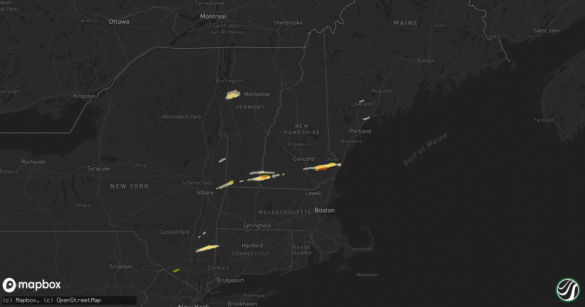
Hail Map in New Hampshire on June 23, 2024
Get this storm
June 23 map
$229
one time, instant access
Download today. No call, no setup
Keep the $229
Bought the map and want the full workflow? Apply the entire $229 to a subscription within 7 days. None of it is wasted.
Every map, not just this one
This buys you this map. Subscription and you get every map we run, in the markets you choose from a few cities to whole states to nationwide. Plus real-time alerts the moment a storm fires.
Contact data
Name, contact info, occupancy, even credit band for addresses in the footprint. You go from where it hit to who to call.
Become the source they trust
Unlimited branding weather history reports on demand. You already have the documented answer ready for the property owner, and you are the one who showed up with it.
Property data and RoofTrace estimates
Pull up any address you have got, its value and the exact code rules for that jurisdiction, straight from One Click Code. Then RoofTrace estimates the squares, pitch, and roof value, priced the way you price.
Storm reports in New Hampshire
New Hampshire
| Date | Description |
|---|---|
| 06/23/20245:50 PM CDT | Delayed report...trained spotter observed numerous trees down on the south side of berlin. Time estimated via radar. |
| 06/23/20245:45 PM CDT | Amateur radio relayed reports of hail up to the size of golf balls on portsmouth ave in greenland. |
| 06/23/20245:44 PM CDT | Trees and wires down in road. Time estimated by radar. |
| 06/23/20245:32 PM CDT | Ne511 reported a tree down... Reducing nh 113 to one lane. Time estimated by radar. |
| 06/23/20245:30 PM CDT | Golf ball sized hail on rt. 101. |
| 06/23/20245:28 PM CDT | Several trees and electrical poles down in lee. Time estimated by radar. |
| 06/23/20245:23 PM CDT | Trees and wires down. Time estimated by radar. |
| 06/23/20245:22 PM CDT | Trees and wires down and on fire. Time estimated by radar. |
| 06/23/20244:55 PM CDT | Delayed report...trees down on gregg mill rd... Byam rd and river rd |
| 06/23/20244:55 PM CDT | Amateur radio relayed report of powerlines down on boynton street in bedford. |
| 06/23/20244:50 PM CDT | Tree down on primary. Time estimated by radar. |
| 06/23/20244:35 PM CDT | Delayed report...trained spotter observed numerous trees down in new boston following severe storm. Time estimated via radar. |
| 06/23/20244:30 PM CDT | Delayed report...amateur radio relayed report of large trees downed on route 77 north of new boston. Time estimated via radar. |
| 06/23/20244:15 PM CDT | Delayed report...trained spotter observed a bent stop sign and storm damage debris on norway hill rd and kimball rd in antrim. Time estimated via radar. |
| 06/23/20244:15 PM CDT | Delayed report...spotter observed trees down on the shoulder of us hwy 202 on north end of peterborough near ferguson creek bridge. Time estimated via radar. |
| 06/23/20244:15 PM CDT | Delayed report...tree down blocking shaker road in canterbury. Relayed by amateur radio. Time estimated via radar. |
| 06/23/20244:06 PM CDT | Tree down on road. Time estimated by radar. |
| 06/23/20244:00 PM CDT | Delayed report...trained spotter observed numerous trees down near highway 101 and old harrisville rd in dublin. Time estimated via radar. |
| 06/23/20244:00 PM CDT | Delayed report...tree and powerlines down blocking nh-114 in the area of music hill rd in sutton. |
| 06/23/20243:55 PM CDT | A local report indicates 1.30 inch wind near 3 WNW Swanzey |
| 06/23/20243:41 PM CDT | Tree on wires. Time estimated by radar. |
| 06/23/20243:40 PM CDT | Multiple trees down on wires on base hill rd in keene. |
| 06/23/20243:40 PM CDT | Tree down blocking west hill rd in keene. |
| 06/23/20243:30 PM CDT | A local report indicates 1.50 inch wind near 1 NNE Chesterfield |
| 06/23/20243:30 PM CDT | Reported by weather spotter. |
| 06/23/20243:30 PM CDT | Tree across road. Time estimated by radar. |
| 06/23/20243:10 PM CDT | Reported by weather spotter... Delayed report. Trees down on plains rd in west claremont. Time estimated by radar. |
| 06/23/20243:10 PM CDT | Sto |
| 06/23/20243:10 PM CDT | Storm chaser reported a tree |
| 06/23/20243:05 PM CDT | Delayed report...tree down blocking nh-12 in the area of caryl ln in charlestown. Time estimated via radar. |
All States Impacted by Hail Map on June 23, 2024
Cities Impacted by Hail Map on June 23, 2024
- Easton, PA
- Phillipsburg, NJ
- Stewartsville, NJ
- Petersburg, NE
- North Ferrisburgh, VT
- Ferrisburgh, VT
- New Haven, VT
- Vergennes, VT
- Bristol, VT
- Hinesburg, VT
- Charlotte, VT
- Starksboro, VT
- Huntington, VT
- Greenwich, NY
- Salem, NY
- Cossayuna, NY
- Averill Park, NY
- Petersburg, NY
- Cropseyville, NY
- Pownal, VT
- Pritchett, CO
- Bennington, VT
- Poughkeepsie, NY
- Pleasant Valley, NY
- Verbank, NY
- Lagrangeville, NY
- Brattleboro, VT
- West Chesterfield, NH
- Chesterfield, NH
- Springfield, CO
- Millbrook, NY
- Patagonia, AZ
- Hinsdale, NH
- Dover Plains, NY
- Stamford, VT
- Sonoita, AZ
- Swanzey, NH
- Spofford, NH
- Kent, CT
- Wassaic, NY
- Wingdale, NY
- Readsboro, VT
- Marlborough, NH
- Williamstown, MA
- Newfane, VT
- Hancock, NH
- Harrisville, NH
- Keene, NH
- Dublin, NH
- Vail, AZ
- Westmoreland, NH
- Nogales, AZ
- Elgin, AZ
- Hereford, AZ
- Fort Huachuca, AZ
- Tumacacori, AZ
- Amado, AZ
- Rio Rico, AZ
- Green Valley, AZ
- Goffstown, NH
- Granada, CO
- Manchester, NH
- Hooksett, NH
- Nottingham, NH
- Epping, NH
- Raymond, NH
- Goshen, NY
- Florida, NY
- Lee, NH
- Durham, NH
- Newmarket, NH
- Candia, NH
- Fremont, NH
- Dover, NH
- Portsmouth, NH
- Newfields, NH
- Auburn, ME
- Lewiston, ME
- Greene, ME
- South Newfane, VT
- Poland, ME
- Minot, ME
- Putney, VT
- Williamsville, VT
- Sullivan, NH
- Freeport, ME
- Pownal, ME
- North Yarmouth, ME
- Brunswick, ME
- Yarmouth, ME
- Rhinebeck, NY
- Billings, MT
- Red Hook, NY
- Auburn, NH
- Milton, NY
- Worden, MT
- Williamstown, NJ
- Franklinville, NJ
- Voorhees, NJ
- Berlin, NJ
- Gibbsboro, NJ
- Clementon, NJ
- West Berlin, NJ
- Marlton, NJ
- Waterford Works, NJ
- Sicklerville, NJ
- Hammonton, NJ
- Pemberton, NJ
- Vincentown, NJ
- Medford, NJ
- Browns Mills, NJ
- Chatsworth, NJ
- Shepherd, MT
- Nelson, NH
- Ingomar, MT
- Deerfield, NH
- Forsyth, MT
- Barrington, NH
- Earleville, MD
- Cohagen, MT
- Berlin, NY
- Wolf Point, MT
- Poplar, MT
- Frazer, MT
- Columbus, ND
- Portal, ND
- Wiota, IA
- Flaxton, ND
- Lignite, ND
- Bowbells, ND
- Kenmare, ND
- Circle, MT
- Anita, IA
- Sherwood, ND
- Brockton, MT
- Fort Peck, MT
- Mohall, ND
- Antler, ND
- Tolley, ND
- Westhope, ND
- Lansford, ND
- Maxbass, ND
- Fairview, MT
- Upham, ND
- Newburg, ND
- Menlo, IA
- Casey, IA
- Kramer, ND
- Williston, ND
- Bainville, MT
- Willow City, ND
- Towner, ND
- Bantry, ND
- Rugby, ND
- Stanley, ND
- Hebron, ND
- Glen Ullin, ND
- Des Lacs, ND
- Berthold, ND
- Burlington, ND
- Kittery, ME
- Kittery Point, ME
- Eliot, ME


