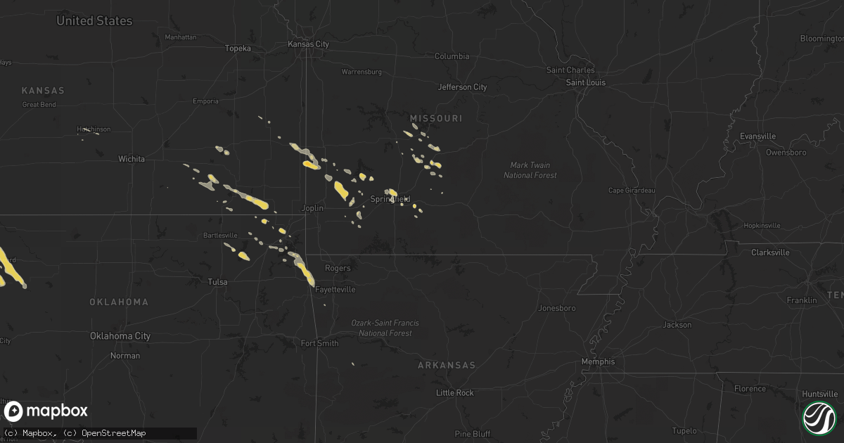
Hail Map on June 23, 2011
Get this storm
June 23 map
$229
one time, instant access
Download today. No call, no setup
Keep the $229
Bought the map and want the full workflow? Apply the entire $229 to a subscription within 7 days. None of it is wasted.
Every map, not just this one
This buys you this map. Subscription and you get every map we run, in the markets you choose from a few cities to whole states to nationwide. Plus real-time alerts the moment a storm fires.
Contact data
Name, contact info, occupancy, even credit band for addresses in the footprint. You go from where it hit to who to call.
Become the source they trust
Unlimited branding weather history reports on demand. You already have the documented answer ready for the property owner, and you are the one who showed up with it.
Property data and RoofTrace estimates
Pull up any address you have got, its value and the exact code rules for that jurisdiction, straight from One Click Code. Then RoofTrace estimates the squares, pitch, and roof value, priced the way you price.
States Impacted by Hail Map on June 23, 2011
Storm reports
West Virginia
| Date | Description |
|---|---|
| 06/23/20114:30 PM CDT | Trees down at observer home. Nickel size hail. |
| 06/23/20114:10 PM CDT | Numerous trees and power lines down along lick creek road. |
| 06/23/20113:24 PM CDT | Tree branches down |
| 06/23/20112:34 PM CDT | Trees down. House collapsed not sure what caused it. |
| 06/22/20118:24 PM CDT | Trees down on route 119 near lucado road |
New Jersey
| Date | Description |
|---|---|
| 06/23/20119:00 AM CDT | Numerous trees reported down throughout the county |
Tennessee
| Date | Description |
|---|---|
| 06/23/20115:55 PM CDT | A couple of trees down in the sunbright area. |
| 06/23/20115:40 PM CDT | One tree down on leatherwood rd and one down on pine hill rd. |
| 06/23/20114:45 PM CDT | Trees down on hwy 42 near rigman road blocked temporarily |
| 06/23/20114:40 PM CDT | Trees down across southern portion of county. |
| 06/23/20112:35 AM CDT | Numerous trees down across the southern third of the county. Reported by dispatch. |
| 06/23/20112:33 AM CDT | Power lines down on boyds creek highway. |
| 06/23/20111:05 AM CDT | Several trees down across the southern third of the county. Reported by dispatch. |
| 06/23/201112:20 AM CDT | Tornado along western ave. Max winds of 80 mph...path length of 1 mile and width of 100 yards. |
| 06/23/201112:00 AM CDT | Ef1 tornado near the bull run steam plant. Max winds of 90 mph...path lenght of 1.5 miles and width of 80 yards. |
| 06/22/201111:50 PM CDT | Possible tornado touchdown in the edgemoor road areaofclaxton...near the bull run steam plant. Reported by wate tv. |
| 06/22/20117:34 PM CDT | A couple of trees down on tillery and reaves rd |
| 06/22/20117:10 PM CDT | Couple of trees down on oliver springs highway. |
| 06/22/20117:09 PM CDT | Two trees down on maple drive |
New York
| Date | Description |
|---|---|
| 06/23/201111:02 AM CDT | Tree down on whippoorwill crossing. |
| 06/23/201110:33 AM CDT | Golf ball sized hail |
Wyoming
| Date | Description |
|---|---|
| 06/22/201110:33 PM CDT | 2 large old and healthy trees were uprooted. One went through a farm shop and the other through a shed. |
| 06/22/20119:53 PM CDT | A local report indicates 58 MPH wind near RAWLINS |
Oklahoma
| Date | Description |
|---|---|
| 06/22/201111:59 PM CDT | A local report indicates 1.00 inch wind near 2 ESE TALALA |
| 06/22/20119:03 PM CDT | A local report indicates 60 MPH wind near 2 S PUTNAM |
Florida
| Date | Description |
|---|---|
| 06/23/20116:55 PM CDT | Polk county em relayed report of a large tree down in north ft meade. Numerous branches down along hwy 17. Street flooding in the city limits. |
| 06/23/20114:09 PM CDT | A spotter reported thunderstorm wind gusts of 60 mph with dime size hail which lasted 10 minutes near bakersville. |
| 06/23/20113:55 PM CDT | Spotter has reported tress down around his neighborhood near lehigh high acres. |
| 06/23/20113:50 PM CDT | Lehigh acres middle school weather station reported a wind gust of 61 mph. Time estimated. |
| 06/23/20113:15 PM CDT | A nws employee reported trees down in his community. A trampoline was blown over a fence. |
| 06/23/20113:10 PM CDT | Trees were blown down along beaver street between otis road and baldwin. The time of the event was based on radar. |
| 06/23/20112:55 PM CDT | Public report of trees down along interstate 10 at mile marker 342. |
| 06/23/20112:35 PM CDT | Trees and powerlines reported down. Hail up to penny size also reported. Time of event based on radar. |
| 06/23/20111:52 PM CDT | A couple of trees down and powerlines down in the la crosse area. Time estimated based on radar. |
North Carolina
| Date | Description |
|---|---|
| 06/23/20116:58 PM CDT | Tree down on road. Relayed from media. Time estimated from radar. |
| 06/23/20116:42 PM CDT | Multiple trees down. Relayed from 911 center. |
| 06/23/20116:35 PM CDT | Large tree limb down over hwy 58. Time estimated from radar. |
| 06/23/20116:22 PM CDT | Tree down near the intersection of river neck rd and sound side rd. Relayed from 911 center. |
| 06/23/20116:20 PM CDT | Tree down. Time estimated by radar. |
| 06/23/20116:20 PM CDT | Metal storage shed blown over on rocky run road. Report relayed from media. Time estimated from radar. |
| 06/23/20116:12 PM CDT | Tree down on powerlines. Time estimated from radar |
| 06/23/20115:40 PM CDT | Tree down on shed in brinkley place |
| 06/23/20115:35 PM CDT | Dime to quarter size hail fell. |
| 06/23/20115:26 PM CDT | Several trees were blown down. A metal structure was blown into the woods off of bill long rd. |
| 06/23/20115:20 PM CDT | Multiple trees down. Hail reported... But size unknown. Trees also down in beargrass. |
| 06/23/20115:12 PM CDT | Powerlines down on ridgewood dr. Time estimated from radar |
| 06/23/20115:10 PM CDT | Tree limbs down up to 2 inches. Quarter size hail. |
| 06/23/20115:10 PM CDT | Multiple trees down |
| 06/23/20115:05 PM CDT | Large limbs down. |
| 06/23/20115:01 PM CDT | Multiple trees and limbs down on mills inn fire dept road. Relayed from media. Time estimated from radar. |
| 06/23/20114:55 PM CDT | A local report indicates 60 MPH wind near 2 WSW INSTITUTE |
| 06/23/20114:40 PM CDT | Tree down on vehicle near holiday court. Relayed from 911 center |
| 06/23/20114:28 PM CDT | Multiple trees down near mile marker 64. Relayed from 911 center |
| 06/23/20114:22 PM CDT | Tree down on davistown-mercer road. Power lines down nearby. |
| 06/23/20114:20 PM CDT | Tree down. |
| 06/23/20114:19 PM CDT | Tree down on eagles road. |
| 06/23/20114:18 PM CDT | Tree down on us 258 near nc highway 42. |
| 06/23/20114:17 PM CDT | Intersection of hwy 121 and hwy 264 |
| 06/23/20114:15 PM CDT | Numerous trees down along highway 58 and highway 91 |
| 06/23/20114:12 PM CDT | Trees down near hwy 91. Relayed from 911 |
| 06/23/20114:10 PM CDT | Tree down on west main street in clinton. |
| 06/23/20114:09 PM CDT | Tree down on wilson road. |
| 06/23/20114:09 PM CDT | Tree down on maple leaf lane in hobbton. |
| 06/23/20114:06 PM CDT | Tree down on keener road. |
| 06/23/20114:00 PM CDT | Tree down |
| 06/23/20113:51 PM CDT | Several trees down near antioch road and highway 111 |
| 06/23/20113:43 PM CDT | One tree down at perkins road near albert drive |
| 06/23/20113:42 PM CDT | Structural damage to apartment buiilding across street from unc pembroke campus. |
| 06/23/20113:25 PM CDT | Numerous trees and power lines down across the county |
| 06/23/20113:25 PM CDT | Roof blown off building. Numerous trees and powerlines down across maxton. |
| 06/23/20113:16 PM CDT | One tree down at intersection of brogden road and stevens sausage road |
| 06/23/20113:15 PM CDT | Quarter sized hail reported in murraysville. |
| 06/23/20113:12 PM CDT | Trees down near old wire road and 211 |
| 06/23/20113:08 PM CDT | Gust of 75mph winds measured at kilm. |
| 06/23/20113:06 PM CDT | Tree down on 4th street. |
| 06/23/20113:06 PM CDT | Tree down on mcnair avenue. |
| 06/23/20113:05 PM CDT | Large trees reported down on archie mcgugan rd. |
| 06/23/20113:01 PM CDT | Tree down at leisure and bostic road. |
| 06/23/20112:45 PM CDT | Tree down on airbase road. |
| 06/23/20118:48 AM CDT | Large limbs down. |
| 06/23/20114:55 AM CDT | Relayed report from charlotte fd of lines along 7600 block of park rd |
Ohio
| Date | Description |
|---|---|
| 06/23/20116:30 PM CDT | Tree down. |
| 06/23/20116:00 PM CDT | Trees down on pleasant hill road |
| 06/23/20112:45 PM CDT | Numerous tree branches down. One large. |
| 06/23/20112:15 PM CDT | Trees down. |
Montana
| Date | Description |
|---|---|
| 06/23/20116:04 PM CDT | Yellow mule raws station elevation 9200 feet |
| 06/23/20115:00 PM CDT | A metal roof was blown off a trailer or shed in the northern portion of great falls. The roof made contact with a power line and witnesses reported that it triggered so |
| 06/23/20114:55 PM CDT | Winds estimated at 60-70 mph at onset of storm with breif heavy rain and pea sized hail |
| 06/23/20114:40 PM CDT | Golf ball sized hail was reported along the us89 near fort shaw |
| 06/23/20114:05 PM CDT | 50-60 mph winds reported with a thunderstorm...along with pea sized hail and 0.30 inches of brief heavy rainfall. |
| 06/23/20112:50 PM CDT | Public report from salmon lake area |
| 06/23/20112:50 PM CDT | Hail reported at big sky lake. |
| 06/23/20112:45 PM CDT | Hail reported at big sky lake. |
| 06/23/20112:00 PM CDT | Spotter reported some shingle damage and dents in copper roofing. |
| 06/22/201111:40 PM CDT | Winds estimated at 60 mph with a 12 ft fence blown down. |
| 06/22/201110:25 PM CDT | Winds sustained 50-60 mph. |
| 06/22/20119:55 PM CDT | 0.50 inches of rain |
| 06/22/20119:35 PM CDT | A local report indicates 65 MPH wind near 7 N SLEEPING BUFFALO |
| 06/22/20119:01 PM CDT | A local report indicates 1.00 inch wind near 9 SSW CHAPMAN |
| 06/22/20117:05 PM CDT | 59 mph wind gust observed at the havre airport asos. |
Georgia
| Date | Description |
|---|---|
| 06/23/20116:12 PM CDT | One tree down along highway 99. Time estimated based on radar. |
| 06/23/20115:07 PM CDT | Trees were blown down along route 17. Time was estimated from radar. |
| 06/23/20114:52 PM CDT | Tree down near black creek church. |
| 06/23/20114:35 PM CDT | Tree down on a power ine. |
| 06/23/20114:28 PM CDT | Trees down. Roof and chimney sustained damage due to falling trees. Time estimated based on radar. |
| 06/23/20114:26 PM CDT | The public reported the north bound lane of mcwhorter drive on skidaway island is blocked by tree damage. Time estimated based on radar. |
| 06/23/20114:20 PM CDT | Several trees reported down across lanier county. Time estimated by radar. |
| 06/23/20114:19 PM CDT | Several trees reported down in and north of ray city. Time estimated by radar. |
| 06/23/20114:08 PM CDT | Numerous reports of trees down across northern lowndes county. |
| 06/23/20114:08 PM CDT | Tree fell on car. Damage unknown. Time estimated based on radar. |
| 06/23/20114:05 PM CDT | Large tree branches down. 6 inch drawbridge gate broken on the islands expressway.. |
| 06/23/20113:39 PM CDT | Montgomery 911 relayed a report of a tree down near uvalda. |
| 06/23/20113:15 PM CDT | Emergency manager reported 15 trees and some powerlines down south of jesup along ga highway 27. |
| 06/23/20113:10 PM CDT | Spotter reported 2 trees down in the kingsland area. |
| 06/23/20113:05 PM CDT | Public report of a shed blown down on harriets bluff rd. |
| 06/23/20113:00 PM CDT | Trees and powerlines reported down. |
| 06/23/20112:55 PM CDT | Trees and power lines were blown down at exit 7 off of interstate 95 in kingsland. The time of the damage was based on radar. |
| 06/23/20112:15 PM CDT | Public report of 60 mph winds in folkston. |
| 06/23/20112:06 PM CDT | Nws incident meteorologist on site at the honey prairie wildfire complex reported widespread tree damage at the east entrace of the okefenokee nwr. |
| 06/23/20111:30 PM CDT | Numerous trees down and a few powerlines down. |
Idaho
| Date | Description |
|---|---|
| 06/22/20118:12 PM CDT | Still falling at time of observation. |
| 06/22/20118:12 PM CDT | Some hail slightly larger than golf ball. |
| 06/22/20118:11 PM CDT | A local report indicates 2.00 inch wind near MONTPELIER |
South Carolina
| Date | Description |
|---|---|
| 06/23/20116:03 PM CDT | Several trees reported down along highway 61 near the west ashley area. Time estimated based on radar. |
| 06/23/20115:51 PM CDT | 3 large limbs down. 8 to 10 inches in diameter. |
| 06/23/20115:50 PM CDT | Several trees reported down along roadways in the ravenel area. Time estimated based on radar. |
| 06/23/20115:50 PM CDT | 1 large limb down along appian way. |
| 06/23/20115:45 PM CDT | 2 trres down in westcott plantation. |
| 06/23/20115:05 PM CDT | Trees down in seabrook and grays hill |
| 06/23/20115:00 PM CDT | Tree down on rail bed road. |
| 06/23/20115:00 PM CDT | Two single engine airplanes flipped over at conway airport. One airplane was carried over 100 ft. |
| 06/23/20115:00 PM CDT | Tree down at ritter road and catholic hill road |
| 06/23/20114:55 PM CDT | Report of trees down on live oak church rd. |
| 06/23/20114:54 PM CDT | Atleast 15 pine trees down...snapped and uprooted. Large shopping center sign and large fences blown down. All along hwy 501 near carolina forest blvd and gardner lacy |
| 06/23/20114:45 PM CDT | Trees down on peachtree rd. |
| 06/23/20114:40 PM CDT | Tree down on a vehicle. |
| 06/23/20114:36 PM CDT | Numerous trees were reportedly down in carolina forest. The time was estimated based on radar. |
| 06/23/20114:35 PM CDT | Quarter sized hail reported near hwy 544. |
| 06/23/20114:35 PM CDT | Quarter sized hail at hwy 344 and sc 31. |
| 06/23/20114:35 PM CDT | Large tree down at recycle center near hwy 544 and sc 31. |
| 06/23/20114:34 PM CDT | A local report indicates 1.25 inch wind near SOCASTEE |
| 06/23/20114:31 PM CDT | Large tree limbs down at hwy 544 and sc 31. |
| 06/23/20114:30 PM CDT | Half dollar sized hail reported at hwy 544 and sc 31. |
| 06/23/20114:15 PM CDT | Several trees down just off sandhill road. |
| 06/23/20114:15 PM CDT | Trees down near grady road and highway 41. |
| 06/23/20113:28 PM CDT | A few trees reported down within the sampit area. |
| 06/23/20113:16 PM CDT | Trees...up to 12 inches in diameter reportedly down near the intersection of south charleston highway and pocket road. |
| 06/23/20112:48 PM CDT | Numerous trees dow reported in lamar. |
| 06/23/20112:38 PM CDT | Trees down on st charles hwy |
| 06/23/20112:23 PM CDT | Trees down on woodrow rd |
| 06/23/20112:05 PM CDT | Schp reported trees down along us highway 521 |
| 06/23/20111:45 PM CDT | Trees down on country club rd |
| 06/23/20111:35 PM CDT | Multiple reports of trees down along leesburg rd |
| 06/23/20111:28 PM CDT | Skywarn observer reports quarter sized hail garners ferry road near trotter rd. |
| 06/23/20111:21 PM CDT | Trees down along i-26 near mile marker 116. |
Arkansas
| Date | Description |
|---|---|
| 06/23/20113:50 AM CDT | Downed trees. Time estimated via radar. Also hail to half dollars reported. |
Kentucky
| Date | Description |
|---|---|
| 06/23/20116:52 PM CDT | Trees down along cow branch rd off hwy172 and also hwy772 at mm6. Time est from radar. |
| 06/23/20116:40 PM CDT | Several trees down in ashland area and throughout county. |
| 06/23/20116:00 PM CDT | Several trees down throughout area. |
| 06/23/20115:46 PM CDT | Few trees down on cemetery road. |
| 06/23/20115:20 PM CDT | Numerous trees down along horse creek road. |
| 06/23/20113:08 PM CDT | Trees down at england hill 6000 block sr3 |
| 06/23/20112:42 PM CDT | Tree down on power lines |
| 06/23/20111:03 PM CDT | Several trees and power lines down. Tree blown on house. Roofs and barns heavily damaged. All damage confined to a two mile radius of judy. |
| 06/22/20117:30 PM CDT | Spotter reported hail up to 1 inch |
Missouri
| Date | Description |
|---|---|
| 06/23/20116:25 AM CDT | Quarter size hail reported at the intersection of highway 54 and highway j. |
Pennsylvania
| Date | Description |
|---|---|
| 06/23/20113:20 PM CDT | Tree down blocking road. |
| 06/23/20118:30 AM CDT | Two trees down |
| 06/23/20118:30 AM CDT | Rt 209 trees down on roadway and cars |
Cities Impacted by Hail Map on June 23, 2011
- Bonner, MT
- Seeley Lake, MT
- Snowville, UT
- Malad City, ID
- Elkton, FL
- Saint Augustine, FL
- Gate, OK
- Alachua, FL
- Eastover, SC
- Columbia, NJ
- East Stroudsburg, PA
- Olive Hill, KY
- Grayson, KY
- Greenwich, CT
- Stamford, CT
- Arnett, OK
- Sharon, OK
- Vici, OK
- Mutual, OK
- May, OK
- Buffalo, OK
- Woodward, OK
- Laverne, OK
- Seiling, OK
- Fort Supply, OK
- Metter, GA
- Cobbtown, GA
- Lyons, GA
- Lehigh Acres, FL
- Sumter, SC
- Bishopville, SC
- Folkston, GA
- Dumont, NJ
- Cresskill, NJ
- Bergenfield, NJ
- Tenafly, NJ
- Demarest, NJ
- Alpine, NJ
- Yonkers, NY
- Fairfield, MT
- Power, MT
- Sun River, MT
- Cascade, MT
- Fort Shaw, MT
- Vaughn, MT
- Lewistown, MT
- Fargo, OK
- Fort Meade, FL
- Jacksonville, FL
- White Oak, GA
- Woodbine, GA
- Dutton, MT
- Pembroke, GA
- Statesboro, GA
- Brooklet, GA
- Conway, SC
- Oak Ridge, TN
- Clinton, TN
- Oliver Springs, TN
- Hardeeville, SC
- Arcadia, KS
- Liberal, MO
- Springfield, MO
- Bosler, WY
- Valdosta, GA
- Hahira, GA
- Lamar, MO
- Sheldon, MO
- Gainesville, FL
- Micanopy, FL
- Belt, MT
- Edna, KS
- Mound Valley, KS
- Oswego, KS
- Altamont, KS
- Bartlett, KS
- Glenwood, GA
- Stantonsburg, NC
- Walstonburg, NC
- Knoxville, TN
- Charleston, SC
- Howard, KS
- Piedmont, KS
- Orlando, FL
- Geraldine, MT
- Macclenny, FL
- Glen Saint Mary, FL
- Dayton, WY
- Bondurant, WY
- Kalispell, MT
- Independence, KS
- Melrose, FL
- Florahome, FL
- Ridgeland, SC
- Richlands, NC
- Jacksonville, NC
- Climax Springs, MO
- Cross Timbers, MO
- Macks Creek, MO
- Oneida, TN
- Walnut Grove, MO
- Aldrich, MO
- Eldridge, MO
- Lebanon, MO
- Bridger, MT
- Colcord, OK
- Gentry, AR
- Siloam Springs, AR
- Johnston, SC
- Ward, SC
- Tunas, MO
- Lemoyne, NE
- Mount Vernon, GA
- Uvalda, GA
- Elliott, SC
- Groveland, FL
- Seymour, MO
- Farmville, NC
- Savannah, GA
- Allardt, TN
- Jamestown, TN
- Loris, SC
- Montpelier, ID
- Galivants Ferry, SC
- Lakeland, FL
- Welch, OK
- Benson, NC
- Four Oaks, NC
- Maxton, NC
- Moncks Corner, SC
- Summerville, SC
- Mount Vernon, MO
- Miller, MO
- Stotts City, MO
- Wilder, TN
- Dalzell, SC
- Rembert, SC
- Seabrook, SC
- Yemassee, SC
- Eskdale, WV
- Orgas, WV
- Fayetteville, WV
- Gallagher, WV
- Robson, WV
- Kimberly, WV
- Montgomery, WV
- Powellton, WV
- Kincaid, WV
- Wagener, SC
- Whitehall, MT
- Highwood, MT
- Bronaugh, MO
- Tornado, WV
- Hurricane, WV
- Saint Albans, WV
- Montvale, NJ
- West Nyack, NY
- Pearl River, NY
- Westwood, NJ
- Blauvelt, NY
- Saddle River, NJ
- Spring Valley, NY
- Nyack, NY
- Monsey, NY
- Nanuet, NY
- Park Ridge, NJ
- Orangeburg, NY
- Valley Cottage, NY
- Lockwood, MO
- Golden City, MO
- La Russell, MO
- Everton, MO
- Dadeville, MO
- Greenfield, MO
- Bluejacket, OK
- Miami, OK
- Talala, OK
- Oologah, OK
- Claremore, OK
- Chelsea, OK
- Hernando, FL
- Astor, FL
- Sheridan, WY
- Sterling, CO
- Phillipsburg, MO
- Myrtle Beach, SC
- Waycross, GA
- Alamo, GA
- Lumber City, GA
- Jasper, MO
- Sarcoxie, MO
- Bancroft, ID
- Jay, OK
- Millwood, GA
- Manor, GA
- Manhattan, MT
- Saint George, GA
- Thomasville, GA
- Rocky Point, NC
- Albany, GA
- Verona, MO
- McArthur, OH
- Starke, FL
- Lawtey, FL
- Saint Johns, FL
- Lancing, TN
- Deer Lodge, TN
- Wartburg, TN
- Clarkrange, TN
- Sunbright, TN
- Wayne, WV
- Genoa, WV
- Prichard, WV
- Louisa, KY
- Fort Gay, WV
- Ocala, FL
- Augusta, MT
- Register, GA
- West Liberty, KY
- Elkfork, KY
- Wauchula, FL
- Vinita, OK
- Sheldon, SC
- Naples, FL
- Washington, NC
- Green Cove Springs, FL
- Williamston, NC
- Robersonville, NC
- Georgetown, SC
- Hemingway, SC
- Tarawa Terrace, NC
- New Bern, NC
- Green Pond, SC
- Walterboro, SC
- Rincon, GA
- Merritt, NC
- Bayboro, NC
- Fredonia, KS
- Yates Center, KS
- Toronto, KS
- Eatontown, NJ
- Grovespring, MO
- Helmville, MT
- Winter Haven, FL
- Bartow, FL
- Waverly, GA
- Drummond, MT
- Fort Scott, KS
- Powell, TN
- Grass Range, MT
- Roach, MO
- Camdenton, MO
- Boston, GA
- Winter Park, FL
- Maitland, FL
- Monterey, TN
- Cookeville, TN
- Spavinaw, OK
- Eucha, OK
- Milton, WV
- Barboursville, WV
- Salt Rock, WV
- Delaware, OK
- Brunswick, GA
- Hortense, GA
- Huger, SC
- Pantego, NC
- Dillon, MT
- Morriston, FL
- Stoutland, MO
- Gallipolis, OH
- Willow Wood, OH
- Scottown, OH
- Crown City, OH
- Molt, MT
- Broadview, MT
- Jekyll Island, GA
- Newton Grove, NC
- Clinton, NC
- Yulee, FL
- Hilliard, FL
- Kingsland, GA
- Columbia, SC
- Hopkins, SC
- Big Horn, WY
- La Follette, TN
- Hinsdale, MT
- Conrad, MT
- Brady, MT
- Alva, FL
- Punta Gorda, FL
- Estero, FL
- Fort Myers, FL
- Immokalee, FL
- Bern, ID
- Elk City, KS
- Riceboro, GA
- Townsend, GA
- Pollocksville, NC
- Trenton, NC
- Arthur, NE
- Ray City, GA
- Lakeland, GA
- Newton, NJ
- Bartonsville, PA
- Stroudsburg, PA
- Blairstown, NJ
- Lovell, WY
- Shoshoni, WY
- Sylvester, GA
- Wilmington, NC
- Ramsey, NJ
- Tarrytown, NY
- Allendale, NJ
- Scranton, NC
- Fordland, MO
- Richmond Hill, GA
- Apopka, FL
- Sorrento, FL
- Windyville, MO
- Long Lane, MO
- Simms, MT
- Banner, WY
- Windermere, FL
- Winter Garden, FL
- Vidalia, GA
- Bath, NC
- Pinetown, NC
- Belhaven, NC
- Rogersville, MO
- Ravenel, SC
- Riegelwood, NC
- South Charleston, WV
- Arcadia, FL
- Longwood, FL
- Big Timber, MT
- Longs, SC
- Fairland, OK
- West Fork, AR
- Prairie Grove, AR
- Lumber Bridge, NC
- Parkton, NC
- Inverness, FL
- Tabor City, NC
- Pierce City, MO
- Longton, KS
- Hobucken, NC
- Bunnell, FL
- Geyser, MT
- Keystone Heights, FL
- Beaufort, SC
- Coosawhatchie, SC
- Coffeyville, KS
- Caney, KS
- Tallahassee, FL
- Conway, MO
- Gainesboro, TN
- Carter, MT
- Havana, KS
- Murrells Inlet, SC
- Cherryvale, KS
- Bethel, NC
- Edgefield, SC
- Ochopee, FL
- Lava Hot Springs, ID
- Kodak, TN
- Nickerson, KS
- Hutchinson, KS
- Salley, SC
- Bushkill, PA
- Tannersville, PA
- Rowland, NC
- Nashville, GA
- Moody Afb, GA
- Greenup, KY
- Elm City, NC
- Bluffton, SC
- Mooreland, OK
- Coolville, OH
- Grantsboro, NC
- Argillite, KY
- Watts, OK
- Vandemere, NC
- Bronx, NY
- Sloatsburg, NY
- Sterling, NY
- Martville, NY
- Claxton, GA
- Martha, KY
- Malta, MT
- Midway, GA
- Grove, OK
- North Augusta, SC
- Homerville, GA
- Fargo, GA
- Strafford, MO
- Willard, MO
- Havre, MT
- Winifred, MT
- Kila, MT
- Albany, OH
- Lewellen, NE
- Kincaid, KS
- Godwin, NC
- Maple Hill, NC
- Wallace, NC
- Maysville, NC
- Armonk, NY
- Valhalla, NY
- Thornwood, NY
- Pleasantville, NY
- Hawthorne, NY
- Hilger, MT
- Greenville, NC
- Three Forks, MT
- Whitewater, MT
- Callahan, FL
- Big Sandy, MT
- Afton, OK
- Bell, FL
- Branford, FL
- Springfield, GA
- Redfield, KS
- Moundville, MO
- Deerfield, MO
- Huntington, NY
- Cold Spring Harbor, NY
- Hampstead, NC
- Reddick, FL
- Bayville, NY
- Locust Valley, NY
- Dunnellon, FL
- Laurinburg, NC
- Red Springs, NC
- Wagram, NC
- Eustis, FL
- Dunlow, WV
- Cheyenne, WY
- Currie, NC
- Kelly, NC
- Fleming, CO
- Summers, AR
- Stumpy Point, NC
- Buffalo, MO
- Louisburg, MO
- Virgil, KS
- Kitty Hawk, NC
- Turner, MT
- Falcon, MO
- Aynor, SC
- Labelle, FL
- Jamesville, NC
- Ramona, OK
- Shannon, NC
- Patriot, OH
- Oak Hill, OH
- Proctorville, OH
- Busby, MT
- Lamar, SC
- Pinedale, WY
- Monett, MO
- Vass, NC
- Hartville, MO
- High Springs, FL
- Pikeville, NC
- Fremont, NC
- Livingston, TN
- Rickman, TN
- Dixie, GA
- Quitman, GA
- Ona, FL
- Bronson, KS
- Booneville, AR
- Patterson, GA
- North Charleston, SC
- Fort Pierce, FL
- Saco, MT
- Oyster Bay, NY
- Welda, KS
- Arcola, MO
- Floral City, FL
- Chetopa, KS
- Guysville, OH
- Culloden, WV
- West Harrison, NY
- White Plains, NY
- Zolfo Springs, FL
- Moline, KS
- Elk Falls, KS
- Stewart, OH
- Bartlesville, OK
- Tappan, NY
- Piermont, NY
- Franklin Lakes, NJ
- Woodcliff Lake, NJ
- Mahwah, NJ
- Ocoee, FL
- Preston, MO
- Urbana, MO
- McAllister, MT
- Denton, MT
- Shade, OH
- Paisley, FL
- Pinetops, NC
- Macclesfield, NC
- Ashland, KY
- Grovetown, GA
- Barbourville, KY
- Fort Benton, MT
- Pedro, OH
- Clearmont, WY
- Nakina, NC
- Clarendon, NC
- Hanahan, SC
- Paramus, NJ
- Fair Lawn, NJ
- Saint Marys, GA
- Murphy, ID
- Reidsville, GA
- Jerico Springs, MO
- Stokes, NC
- Sandy Hook, KY
- Webbville, KY
- Bearcreek, MT
- Goose Creek, SC
- West Columbia, SC
- Aurora, MO
- Johns Island, SC
- Warthen, GA
- Garnett, KS