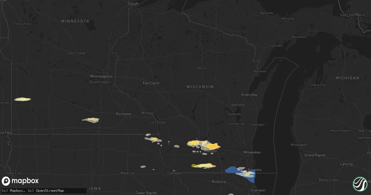
Hail Map in Wisconsin on June 22, 2024
Get this storm
June 22 map
$229
one time, instant access
Download today. No call, no setup
Keep the $229
Bought the map and want the full workflow? Apply the entire $229 to a subscription within 7 days. None of it is wasted.
Every map, not just this one
This buys you this map. Subscription and you get every map we run, in the markets you choose from a few cities to whole states to nationwide. Plus real-time alerts the moment a storm fires.
Contact data
Name, contact info, occupancy, even credit band for addresses in the footprint. You go from where it hit to who to call.
Become the source they trust
Unlimited branding weather history reports on demand. You already have the documented answer ready for the property owner, and you are the one who showed up with it.
Property data and RoofTrace estimates
Pull up any address you have got, its value and the exact code rules for that jurisdiction, straight from One Click Code. Then RoofTrace estimates the squares, pitch, and roof value, priced the way you price.
Storm reports in Wisconsin
Wisconsin
| Date | Description |
|---|---|
| 06/22/20246:58 PM CDT | A local report indicates 1.75 inch wind near 1 W Sun Prairie |
| 06/22/20246:56 PM CDT | A local report indicates 1.00 inch wind near 1 SW Sun Prairie |
| 06/22/20246:55 PM CDT | Structure damage to large shed/barn. Picture via social media. |
| 06/22/20246:54 PM CDT | A local report indicates 1.75 inch wind near 1 N Sun Prairie |
| 06/22/20246:53 PM CDT | A local report indicates 1.25 inch wind near 2 W Sun Prairie |
| 06/22/20246:51 PM CDT | A local report indicates 1.50 inch wind near 3 W Sun Prairie |
| 06/22/20246:49 PM CDT | Picture of measured hail via social media. |
| 06/22/20246:47 PM CDT | A local report indicates 1.25 inch wind near 2 NW Maple Bluff |
| 06/22/20245:39 PM CDT | Trees down over road |
| 06/22/20245:39 PM CDT | Trees down over road and debris blocking roads around cornelia. Possible tornado damage. |
| 06/22/20245:37 PM CDT | Brief ef-0 tornado with tree damage near the intersection of highway o and north lane. Touchdown was observed. |
| 06/21/20248:23 PM CDT | Videos of house and tree damage in janesville on social media. |
| 06/21/20248:22 PM CDT | Nws damage survey confirmed tornado. An ef-1 tornado developed south of geneva lake and moved northeast across the lake before lifting just south of lake como. Multiple |
| 06/21/20248:22 PM CDT | Nws damage survey confirmed tornado. Rated ef-1 with peak wind of 105 mph. |
| 06/21/20248:14 PM CDT | Report from mping: 1-inch tree limbs broken; shingles blown off. |
| 06/21/20248:13 PM CDT | Report from mping: 3-inch tree limbs broken; power poles broken. |
| 06/21/20248:12 PM CDT | Report from mping: 3-inch tree limbs broken; power poles broken. |
| 06/21/20248:11 PM CDT | Report from mping: 3-inch tree limbs broken; power poles broken. |
| 06/21/20248:11 PM CDT | Report from mping: 3-inch tree limbs broken; power poles |
| 06/21/20248:04 PM CDT | Report from mping: 3-inch tree limbs broken; power poles broken. |
| 06/21/20248:03 PM CDT | Report from mping: 3-inch tree limbs broken; power poles broken. |
| 06/21/20248:00 PM CDT | Report from mping: 3-inch tree limbs broken; power poles broken. |
| 06/21/20247:42 PM CDT | Nws storm survey: ef-2 tornado with estimated peak wind speeds of 115mph. Estimated to be on the ground from 7:42pm-7:53pm. Most of the damage was at ef-1 level but a f |
| 06/21/20247:30 PM CDT | An ef-1 rated tornado developed west of watertown... Near the intersection of county roads q and t. The tornado progressed northeastward... Causing substantial damage t |
| 06/21/20247:10 PM CDT | An ef-1 rated tornado developed south of marshall... Progressing northeastward. Multiple farm and outbuildings... A few homes... And numerous trees were damaged. Peak w |
| 06/21/20247:10 PM CDT | Picture of measured hail via social media. |
| 06/21/20247:07 PM CDT | A local report indicates 1.75 inch wind near 2 N Maple Bluff |
All States Impacted by Hail Map on June 22, 2024
Cities Impacted by Hail Map on June 22, 2024
- Rawlins, WY
- Encampment, WY
- Saratoga, WY
- Craig, CO
- Hayden, CO
- Hamilton, CO
- Steamboat Springs, CO
- North Platte, NE
- Maxwell, NE
- Callaway, NE
- Gothenburg, NE
- Esperance, NY
- Sprakers, NY
- Sloansville, NY
- Schoharie, NY
- Central Bridge, NY
- Delanson, NY
- Lake Benton, MN
- Tyler, MN
- Arco, MN
- Ivanhoe, MN
- Branchville, NJ
- Russell, MN
- Lynd, MN
- Marshall, MN
- Valatie, NY
- Niverville, NY
- Old Chatham, NY
- East Chatham, NY
- Chatham, NY
- Canaan, NY
- Austerlitz, NY
- West Stockbridge, MA
- Richmond, MA
- Stockbridge, MA
- South Lee, MA
- Great Barrington, MA
- Pine Plains, NY
- Housatonic, MA
- Monterey, MA
- Stanfordville, NY
- Tyringham, MA
- Millerton, NY
- Amenia, NY
- Delavan, MN
- Minnesota Lake, MN
- Sandisfield, MA
- Norfolk, CT
- Mapleton, MN
- Southfield, MA
- Wells, MN
- New Richland, MN
- Waldorf, MN
- Colebrook, CT
- Winsted, CT
- West Hartford, CT
- Hartford, CT
- East Hartford, CT
- Glastonbury, CT
- Wethersfield, CT
- South Glastonbury, CT
- Rocky Hill, CT
- Wilbraham, MA
- Millbrook, NY
- Meeker, CO
- Hartland, MN
- Ellendale, MN
- Portland, CT
- East Hampton, CT
- Marlborough, CT
- Vernal, UT
- Bantam, CT
- Lakeside, CT
- Morris, CT
- Litchfield, CT
- Staten Island, NY
- Watertown, CT
- Bethlehem, CT
- Sewaren, NJ
- Thomaston, CT
- Northfield, CT
- Plymouth, CT
- Bristol, CT
- Terryville, CT
- Burlington, CT
- Harwinton, CT
- Cobalt, CT
- Colchester, CT
- Waterbury, CT
- Newington, CT
- Oakville, CT
- Wolcott, CT
- Rangely, CO
- Cheshire, CT
- Lavallette, NJ
- Mantoloking, NJ
- Southington, CT
- Farmington, CT
- Thompson, UT
- Highlands, NJ
- Rumson, NJ
- Marion, CT
- Plantsville, CT
- Moodus, CT
- Cromwell, CT
- Prospect, CT
- Trenton, FL
- Teasdale, UT
- Hanksville, UT
- Plainville, CT
- Beacon Falls, CT
- Naugatuck, CT
- Bethany, CT
- Naturita, CO
- Seaside Heights, NJ
- Seaside Park, NJ
- Brick, NJ
- Bayville, NJ
- Hamden, CT
- Skillman, NJ
- Princeton, NJ
- Meriden, CT
- West Milford, NJ
- Andover, CT
- New Britain, CT
- Southbury, CT
- Oxford, CT
- Lock Haven, PA
- Bridgewater, CT
- Brookfield, CT
- South Windsor, CT
- Windsor, CT
- Glendive, MT
- East Haddam, CT
- Avon, CT
- Higganum, CT
- Watsontown, PA
- Muncy, PA
- Montgomery, PA
- Columbia, CT
- Wallingford, CT
- Middlebury, CT
- Jersey Shore, PA
- Middle Haddam, CT
- Hughesville, PA
- Seymour, CT
- Decorah, IA
- Dorchester, IA
- Sandy Hook, CT
- Waterville, PA
- Spring Grove, MN
- Waukon, IA
- Lansing, IA
- New Albin, IA
- Unityville, PA
- Oelwein, IA
- Stanley, IA
- Waterloo, NY
- Geneva, NY
- Muncy Valley, PA
- Glen Gardner, NJ
- Waterville, IA
- Harpers Ferry, IA
- Hackettstown, NJ
- Flanders, NJ
- Wibaux, MT
- Golva, ND
- Bloomingdale, NJ
- Plain, WI
- Loganville, WI
- Hillpoint, WI
- Aurora, IA
- Lamont, IA
- Succasunna, NJ
- Ledgewood, NJ
- Randolph, NJ
- Kenvil, NJ
- Lone Rock, WI
- Seneca Falls, NY
- Budd Lake, NJ
- Long Valley, NJ
- Chester, NJ
- Mine Hill, NJ
- Holmes, NY
- Carmel, NY
- Platteville, WI
- Lansing, NY
- Groton, NY
- Gays Mills, WI
- Afton, IA
- Flemington, NJ
- Pittstown, NJ
- Annandale, NJ
- North Freedom, WI
- Spring Green, WI
- Prairie Du Sac, WI
- Sauk City, WI
- Wharton, NJ
- Rockaway, NJ
- Dover, NJ
- Eastman, WI
- Port Murray, NJ
- Lopez, PA
- Danbury, CT
- Shannon City, IA
- New Fairfield, CT
- New Milford, CT
- Amidon, ND
- Rhame, ND
- Muscoda, WI
- Butler, NJ
- Hecla, SD
- Claremont, SD
- Britton, SD
- Easton, CT
- Newtown, CT
- Monroe, CT
- Denville, NJ
- Freeville, NY
- Bethel, CT
- Boscobel, WI
- Blue River, WI
- Lebanon, NJ
- Boonton, NJ
- Mazomanie, WI
- Arena, WI
- Savannah, NY
- Lodi, WI
- Belle Mead, NJ
- Hillsborough, NJ
- Cortland, NY
- Dryden, NY
- Trumbull, CT
- Dane, WI
- Cross Plains, WI
- Shullsburg, WI
- Amherst, SD
- Black Earth, WI
- Maitland, MO
- Shelton, CT
- Tingley, IA
- Sentinel Butte, ND
- Bowman, ND
- Slaterville Springs, NY
- Marathon, NY
- Walton, NY
- Sidney Center, NY
- Unadilla, NY
- Masonville, NY
- Madison, WI
- Waunakee, WI
- Middleton, WI
- Deforest, WI
- Phelps, NY
- Clifton Springs, NY
- Arlington, WI
- Windsor, WI
- Argyle, WI
- Darlington, WI
- Turbotville, PA
- Maryville, MO
- Lyons, NY
- Clyde, NY
- Monticello, WI
- Monroe, WI
- Langford, SD
- Sun Prairie, WI
- Collins, IA
- Maxwell, IA
- Mingo, IA
- Ravenwood, MO
- Milford, NJ
- Bloomsbury, NJ
- Easton, PA
- Phillipsburg, NJ
- South Wayne, WI
- Woodford, WI
- Gratiot, WI
- Califon, NJ
- Ridgeway, WI
- Barneveld, WI
- Langdon, ND
- Clinton, NJ
- Asbury, NJ
- Hampton, NJ
- Marshall, WI
- Columbus, WI
- Cottage Grove, WI
- Alsen, ND
- Parnell, MO
- Blue Mounds, WI
- Mount Horeb, WI
- Union Springs, NY
- Verona, WI
- Scranton, ND
- Franklin, NY
- Albany, WI
- Newark, NY
- Wales, ND
- Brodhead, WI
- Washington, NJ
- Kutztown, PA
- Deerfield, WI
- Evansville, WI
- Janesville, WI
- Footville, WI
- Orfordville, WI
- Scipio Center, NY
- Aurora, NY
- Manchester, IA
- Greeley, IA
- Edgewood, IA
- Knoxville, IA
- Brooktondale, NY
- Waterloo, WI
- Port Byron, NY
- Delhi, NY
- Millville, PA
- Morrisonville, WI
- Fillmore, MO
- New England, ND
- Hettinger, ND
- Reeder, ND
- Cato, NY
- Hannibal, NY
- Martville, NY
- Belmont, WI
- Mineral Point, WI
- Locke, NY
- Weedsport, NY
- Red Creek, NY
- Fulton, NY
- Benton, PA
- Moravia, NY
- Auburn, NY
- Juda, WI
- Decatur, IA
- Stewartsville, NJ
- Harvey, IA
- Pella, IA
- Rosendale, MO
- Savannah, MO
- Trumansburg, NY
- Interlaken, NY
- Lodi, NY
- Richford, NY
- Leon, IA
- Mcfarland, WI
- Watertown, WI
- Lemmon, SD
- Hamden, NY
- Baldwinsville, NY
- Rea, MO
- Lineville, IA
- Bethlehem, PA
- Hellertown, PA
- King Ferry, NY
- Grinnell, IA
- Genoa, NY
- Dubuque, IA
- Riegelsville, PA
- Delancey, NY
- Clio, IA
- Allerton, IA
- Clinton, WI
- Darien, WI
- Delavan, WI
- Walworth, WI
- Williams Bay, WI
- Sharon, WI
- Elkhorn, WI
- Lake Geneva, WI
- Fontana, WI
- Andes, NY
- Ithaca, NY
- Harveys Lake, PA
- Genoa City, WI
- Burlington, WI
- Spring Grove, IL
- Hebron, IL
- Mchenry, IL
- Richmond, IL
- Twin Lakes, WI
- Ringwood, IL
- Salem, WI
- Silver Lake, WI
- Margaretville, NY
- Harvard, IL
- Lankin, ND
- Wilmot, WI
- Trevor, WI
- Antioch, IL
- Bristol, WI
- Fox Lake, IL
- Keldron, SD
- Kenosha, WI
- Pleasant Prairie, WI
- Wadsworth, IL
- Grayslake, IL
- Gurnee, IL
- Ingleside, IL
- Libertyville, IL
- Zion, IL
- Round Lake, IL
- Waukegan, IL
- Lake Villa, IL
- Great Lakes, IL
- Winthrop Harbor, IL
- North Chicago, IL
- Meadow, SD
- McIntosh, SD
- Fordville, ND
- Lake Forest, IL
- Lake Bluff, IL
- Mundelein, IL
- Dupree, SD
- Wolcott, NY
- Oswego, NY
- Sterling, NY
- Jordan, NY
- Ringoes, NJ
- Howes Cave, NY
- Central Square, NY
- Leonardo, NJ
- Port Monmouth, NJ
- Keansburg, NJ
- Middletown, NJ
- Belford, NJ
- Atlantic Highlands, NJ
- Tatamy, PA
- Whitehouse Station, NJ
- Hebron, CT
- Wapello, IA
- Morning Sun, IA
- Winfield, IA
- Homer, NY
- Unionville, CT
- Phoenix, NY
- Bloomfield, CT
- Sharon, CT
- Haddam, CT
- Maple Park, IL
- Cortland, IL
- Dekalb, IL
- Sycamore, IL
- Glen Ellyn, IL
- Naperville, IL
- Wheaton, IL
- Lisle, IL
- Western Springs, IL
- Villa Park, IL
- Downers Grove, IL
- Lombard, IL
- Westmont, IL
- Oak Brook, IL
- Hinsdale, IL
- Willowbrook, IL
- Darien, IL
- Woodridge, IL
- Clarendon Hills, IL
- La Grange, IL
- Summit Argo, IL
- Justice, IL
- Willow Springs, IL
- Kansas City, MO
- Independence, MO
- Lees Summit, MO
- Grain Valley, MO
- Blue Springs, MO
- Greenwood, MO
- Woodbury, CT
- Torrington, CT
- Gouldsboro, PA
- Moscow, PA
- Scranton, PA
- Pennellville, NY
- Brewerton, NY
- Clay, NY
- Lebanon, CT
- Taberg, NY
- Camden, NY
- Lee Center, NY
- Ava, NY
- Boonville, NY
- Bolton, CT
- Manchester, CT
- Vernon Rockville, CT
- Middlefield, CT
- Gladwin, MI
- Alger, MI
- Elburn, IL
- Warrenville, IL
- West Chicago, IL
- Winfield, IL


