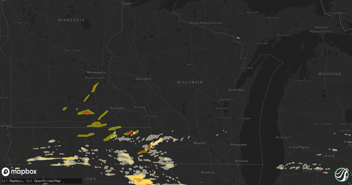
Hail Map in Wisconsin on June 22, 2015
Get this storm
June 22 map
$229
one time, instant access
Download today. No call, no setup
Keep the $229
Bought the map and want the full workflow? Apply the entire $229 to a subscription within 7 days. None of it is wasted.
Every map, not just this one
This buys you this map. Subscription and you get every map we run, in the markets you choose from a few cities to whole states to nationwide. Plus real-time alerts the moment a storm fires.
Contact data
Name, contact info, occupancy, even credit band for addresses in the footprint. You go from where it hit to who to call.
Become the source they trust
Unlimited branding weather history reports on demand. You already have the documented answer ready for the property owner, and you are the one who showed up with it.
Property data and RoofTrace estimates
Pull up any address you have got, its value and the exact code rules for that jurisdiction, straight from One Click Code. Then RoofTrace estimates the squares, pitch, and roof value, priced the way you price.
Storm reports in Wisconsin
Wisconsin
| Date | Description |
|---|---|
| 06/22/20151:11 PM CDT | Tree limb down on power lines at the 700 block of jones street |
| 06/22/201511:20 AM CDT | Tree was uprooted and many small branches were down. A few large branches 3 to 4 inches in diameter were also down. |
| 06/22/201511:19 AM CDT | 12-14 inch diameter tree across road at 92nd and wilur. |
| 06/22/201511:15 AM CDT | Two large tree branches down at 42nd and beethoven. Time estimated from radar. Relayed via twitter. |
| 06/22/201511:04 AM CDT | Large tree snapped on muskego dam road in extreme southeast waukesha county. Time estimated from radar. Relayed via twitter. |
| 06/22/201511:04 AM CDT | Two foot diameter tree snapped. Time estimated by radar. Relayed via facebook. |
| 06/22/201510:45 AM CDT | Large tree limb down at the corner of 5th and dodge st. Relayed via facebook. |
| 06/22/201510:42 AM CDT | Numerious trees and power lines down through out the city |
| 06/22/201510:36 AM CDT | Wind damage at n926 co. Rd. D in whitewater. 12-14 inch diameter healthy tree knocked over. Large healthy tree limbs down. Nearest intersection is co. Rd. D and hwy 59. |
| 06/22/201510:24 AM CDT | Trees and power lines down at various locations in the city |
| 06/22/201510:18 AM CDT | Several large tree branches down on blizzard road. A large limb fell on the back of a car... Damaging it. Time estimated from radar. |
| 06/22/201510:06 AM CDT | Trees and power lines down across northern green county |
| 06/22/20159:49 AM CDT | Sheriff office reports numerous trees and power lines down through out the entire county |
| 06/22/20159:45 AM CDT | Pole and shed blown down near jonesdale. Relayed via twitter. |
| 06/22/20159:40 AM CDT | Town of hollandale is shut down due to damage from numerous trees down. Structural damage to homes was also reported. |
| 06/22/20159:40 AM CDT | Numerous 10 to 30 inch diameter trees snapped near the town of waldwick. |
| 06/22/20159:25 AM CDT | Tree limbs down |
| 06/22/20159:20 AM CDT | Reports of possible barn damage and trees downed in five points area. |
| 06/22/20159:20 AM CDT | Several trees down estimated 70 mph wind |
| 06/22/20159:12 AM CDT | Power lines down |
| 06/22/20159:12 AM CDT | Trees blown down |
| 06/22/20159:11 AM CDT | A local report indicates 65 MPH wind near HAZEL GREEN |
| 06/22/20159:05 AM CDT | Barn blown down |
| 06/22/20159:05 AM CDT | Numerous power lines down. |
| 06/22/20159:01 AM CDT | Trees and power lines down |
| 06/22/20159:00 AM CDT | Numerious trees down in southeast dane and north rock county including newville township and evansville. |
| 06/22/20158:38 AM CDT | Multiple power poles snapped on highway 27 just east of prairie du chien |
| 06/22/20158:35 AM CDT | Home had part of its roof blown off...many trees and power lines down in the city |
| 06/22/20157:46 AM CDT | Image sent via social media |
| 06/22/20157:43 AM CDT | A local report indicates 1.00 inch wind near 2 NW WAUZEKA |
| 06/22/20157:23 AM CDT | Multiple reports of quarter size hail on the north side of prairie du chien. |
| 06/22/20157:19 AM CDT | At police officers homes. |
All States Impacted by Hail Map on June 22, 2015
Cities Impacted by Hail Map on June 22, 2015
- Gardner, IL
- Bronson, IA
- Salix, IA
- Trenton, NC
- Bowman, SC
- Potosi, WI
- Platteville, WI
- Cuba City, WI
- Dickeyville, WI
- Hazel Green, WI
- Hiawatha, IA
- Cedar Rapids, IA
- Toddville, IA
- Palo, IA
- Marion, IA
- Robins, IA
- Shellsburg, IA
- Rockwell City, IA
- Jolley, IA
- Ely, IA
- Springer, NM
- Maxwell, NM
- Raton, NM
- Central City, IA
- Springport, MI
- Albion, MI
- Bellevue, MI
- Marshall, MI
- Olivet, MI
- Battle Creek, MI
- La Porte City, IA
- Waterloo, IA
- Alta Vista, IA
- Ossian, IA
- West Union, IA
- Lancaster, WI
- Saint Augustine, FL
- Nashville, MI
- Las Vegas, NM
- San Jose, NM
- Cedar Falls, IA
- Mentor, OH
- Mendota, IL
- Earlville, IL
- Live Oak, FL
- Madison, FL
- Williams, IA
- Pomeroy, IA
- Webster City, IA
- Somers, IA
- Moorland, IA
- Manson, IA
- Barnum, IA
- Palmer, IA
- Lytton, IA
- Galt, IA
- Vincent, IA
- Humboldt, IA
- Fort Dodge, IA
- Thor, IA
- Dows, IA
- Clarion, IA
- Duncombe, IA
- Alden, IA
- Blairsburg, IA
- Sac City, IA
- Gilmore City, IA
- Woolstock, IA
- Badger, IA
- Eagle Grove, IA
- Fonda, IA
- Clare, IA
- Goldfield, IA
- Postville, IA
- Waukon, IA
- Bloomingdale, GA
- Savannah, GA
- Braidwood, IL
- Wilmington, IL
- Swainsboro, GA
- Humphreys, MO
- Patrick Springs, VA
- Bassett, VA
- Stuart, VA
- Bell, FL
- Branford, FL
- Punta Gorda, FL
- Arcadia, FL
- South Haven, MI
- Sumner, GA
- Ty Ty, GA
- Bosworth, MO
- Keosauqua, IA
- Milton, IA
- Udell, IA
- Bonaparte, IA
- Bloomfield, IA
- Moravia, IA
- Unionville, IA
- Moulton, IA
- Cantril, IA
- Drakesville, IA
- Pulaski, IA
- Memphis, MO
- Mount Sterling, IA
- Arbela, MO
- McGregor, IA
- Marquette, IA
- Lawler, IA
- New Hampton, IA
- Elma, IA
- Calmar, IA
- Fort Atkinson, IA
- Waucoma, IA
- Deerfield, MI
- Dundee, MI
- Petersburg, MI
- Deckerville, MI
- Carsonville, MI
- Alexander, IA
- Thornton, IA
- Rensselaer, IN
- Gorin, MO
- Rembrandt, IA
- Marathon, IA
- Sioux Rapids, IA
- Albert City, IA
- Linn Grove, IA
- Reynolds, IL
- Taylor Ridge, IL
- Dalzell, SC
- Bishopville, SC
- Rembert, SC
- Sumter, SC
- La Moille, IL
- Harmon, IL
- Dixon, IL
- Ohio, IL
- Sublette, IL
- Amboy, IL
- Newell, IA
- Linesville, PA
- Conneautville, PA
- Meadville, PA
- Conneaut Lake, PA
- Soperton, GA
- Dunnellon, FL
- Coggon, IA
- Hopkinton, IA
- Monticello, IA
- Ryan, IA
- Ashburn, GA
- Naples, FL
- Fairfax, IA
- Girard, GA
- Sardis, GA
- Prairie Du Chien, WI
- Sheffield, IL
- White Oak, GA
- Waverly, GA
- Hamilton, IA
- Albia, IA
- Lovilia, IA
- Knoxville, IA
- Steuben, WI
- Wauzeka, WI
- Boscobel, WI
- Kirksville, MO
- La Plata, MO
- Elmer, MO
- Hephzibah, GA
- Blythe, GA
- Clyde, OH
- Castalia, OH
- Vickery, OH
- Serafina, NM
- Ribera, NM
- Dublin, GA
- North, SC
- Centerville, IA
- Blakesburg, IA
- Farmington, IA
- Luray, MO
- Seneca, IL
- Marseilles, IL
- Dorchester, SC
- Harleyville, SC
- Milan, MO
- Gladbrook, IA
- Beaman, IA
- Adel, GA
- Clifton, TN
- Bath Springs, TN
- Morris, IL
- Elwood, IL
- Coal City, IL
- Channahon, IL
- Minooka, IL
- Atlanta, MO
- Summerville, SC
- Nichols, IA
- Port Charlotte, FL
- Decorah, IA
- Sauk City, WI
- Mazomanie, WI
- Guttenberg, IA
- Holy Cross, IA
- Cassville, WI
- Axis, AL
- Estill, SC
- Citronelle, AL
- Trenton, FL
- Youngstown, FL
- Denison, IA
- Dundee, IA
- Aurora, IA
- Lamont, IA
- Strawberry Point, IA
- Deford, MI
- Cass City, MI
- Morrison, IL
- Rock Falls, IL
- Fulton, IL
- Sterling, IL
- Chadwick, IL
- Ridgeville, SC
- Hahira, GA
- Nashville, GA
- Ray City, GA
- Clarendon, NC
- Chadbourn, NC
- Milton, FL
- Greenville, FL
- Baring, MO
- Ubly, MI
- Royal Center, IN
- Montville, OH
- Chardon, OH
- Charles City, IA
- Pemberville, OH
- Bowling Green, OH
- Conway, SC
- Manchester, IA
- Winthrop, IA
- Masonville, IA
- Winnsboro, SC
- Ladson, SC
- Wyoming, IA
- Onslow, IA
- Northfield, OH
- Bedford, OH
- Macedonia, OH
- Lisbon, IA
- Mount Vernon, IA
- Stanwood, IA
- Olin, IA
- Mechanicsville, IA
- Momence, IL
- Pembroke Township, IL
- Belmond, IA
- Kanawha, IA
- Monetta, SC
- Batesburg, SC
- Manteno, IL
- Jesup, GA
- Alta, IA
- Storm Lake, IA
- Ardmore, AL
- Bennett, IA
- Martinsville, VA
- Elkader, IA
- Farmersburg, IA
- Luana, IA
- Saint Olaf, IA
- Monona, IA
- Elgin, IA
- Cherokee, IA
- Marcus, IA
- Quimby, IA
- Varina, IA
- Aurelia, IA
- Correctionville, IA
- Pocahontas, IA
- Washta, IA
- Pierson, IA
- West Farmington, OH
- Crawfordville, FL
- Lansing, IA
- Eldora, IA
- Iowa Falls, IA
- Clarksville, IA
- Tripoli, IA
- Waverly, IA
- Sheridan, IL
- Serena, IL
- Ottawa, IL
- Promise City, IA
- Wray, GA
- Interlachen, FL
- East Dubuque, IL
- Wiggins, MS
- Curlew, IA
- Avoca, WI
- Woodman, WI
- Bagley, WI
- Lone Rock, WI
- Richland Center, WI
- Mount Hope, WI
- Highland, WI
- Gays Mills, WI
- Muscoda, WI
- Blue River, WI
- Garnavillo, IA
- Martelle, IA
- Anamosa, IA
- Grand Ridge, IL
- Ida, MI
- Bloomington, WI
- Center Junction, IA
- Green City, MO
- Ruthven, IA
- Dickens, IA
- Mazon, IL
- Citra, FL
- Fort McCoy, FL
- Anthony, FL
- Oregon, IL
- Franklin Grove, IL
- Bangor, MI
- Arabi, GA
- Cordele, GA
- Attica, MI
- Lapeer, MI
- Wheatland, IA
- Calamus, IA
- Sanderson, FL
- Imlay City, MI
- Sioux City, IA
- Chiefland, FL
- Cove City, NC
- Carriere, MS
- Poplarville, MS
- Seymour, IA
- Corydon, IA
- Orchard, IA
- Osage, IA
- Whiteville, NC
- Astor, FL
- Sandusky, OH
- Port Clinton, OH
- Mobile, AL
- Saraland, AL
- Muscatine, IA
- Lyndon, IL
- Hazleton, IA
- Jesup, IA
- Independence, IA
- Dunkerton, IA
- Oelwein, IA
- Fairbank, IA
- Rolfe, IA
- Arena, WI
- Spring Green, WI
- Lodge, SC
- Traer, IA
- Conrad, IA
- Liscomb, IA
- Novinger, MO
- Cleveland, OH
- Clinton, IA
- Sumner, IA
- Naylor, GA
- New Boston, MO
- Winigan, MO
- Linneus, MO
- Livonia, MO
- Browning, MO
- Purdin, MO
- Bucklin, MO
- Unionville, MO
- Green Castle, MO
- Cincinnati, IA
- Worthington, MO
- Brookfield, MO
- Jacksonville, FL
- Kankakee, IL
- Bourbonnais, IL
- Grant Park, IL
- Collinsville, VA
- Fieldale, VA
- Macon, MO
- Bevier, MO
- McAlpin, FL
- Wellborn, FL
- Bethel Springs, TN
- Selmer, TN
- Orangeburg, SC
- Saint Matthews, SC
- Webb, IA
- Moss Point, MS
- Mount Auburn, IA
- Corinth, MS
- Baxley, GA
- Eastman, WI
- Waterville, IA
- Ferryville, WI
- Harpers Ferry, IA
- Hartford, WI
- Dexter, MI
- Ann Arbor, MI
- Buckingham, IA
- Havelock, IA
- Worthington, IA
- Cascade, IA
- Britton, MI
- La Motte, IA
- Dubuque, IA
- Bellevue, IA
- Galena, IL
- Scales Mound, IL
- Garrettsville, OH
- Southington, OH
- Atkins, IA
- Grand Bay, AL
- Eight Mile, AL
- Lumpkin, GA
- Goose Lake, IA
- Prophetstown, IL
- Thomson, IL
- Welton, IA
- Charlotte, IA
- Lost Nation, IA
- De Witt, IA
- Eldena, IL
- Delmar, IA
- Grand Mound, IA
- Bryant, IA
- Sabula, IA
- Walnut, IL
- Tennille, GA
- Francesville, IN
- Plainfield, IA
- Marceline, MO
- Exline, IA
- Ethel, MO
- New Cambria, MO
- Glenwood, MO
- Pollock, MO
- Coatsville, MO
- Livingston, AL
- Jacksonville, MO
- Excello, MO
- Cairo, MO
- Birch Run, MI
- Saginaw, MI
- Okatie, SC
- Vinton, IA
- Alburnett, IA
- Indianola, IA
- Ackworth, IA
- Georgetown, SC
- Fort Stewart, GA
- Sparks, GA
- Adrian, GA
- Downing, MO
- Otsego, MI
- Gobles, MI
- Kalamazoo, MI
- Plainwell, MI
- Spragueville, IA
- Maquoketa, IA
- Camilla, GA
- Newton, GA
- Aiken, SC
- Gresham, SC
- Melcher Dallas, IA
- Chariton, IA
- Melrose, IA
- Columbia, IA
- Lacona, IA
- Middleton, TN
- Newington, GA
- Ehrhardt, SC
- Springville, IA
- Center Point, IA
- Morley, IA
- Stockton, GA
- Ridgeway, IA
- Cimarron, NM
- Emmetsburg, IA
- Leesville, SC
- Grand Junction, MI
- Bloomingdale, MI
- Allegan, MI
- Rutledge, MO
- Buckingham, IL
- Reddick, IL
- Castalia, IA
- Laclede, MO
- Meadville, MO
- Sumner, MO
- Keystone Heights, FL
- Florahome, FL
- Hardeeville, SC
- Ludowici, GA
- Glen Saint Mary, FL
- Timmonsville, SC
- Lamar, SC
- Cashiers, NC
- Sapphire, NC
- Perrysburg, OH
- Port Wentworth, GA
- Saint Charles, MI
- Merrill, MI
- Greene, IA
- Lone Tree, IA
- Riceboro, GA
- Midway, GA
- Saint George, SC
- Maybee, MI
- Andrew, IA
- Carrollton, MO
- Candler, NC
- Readlyn, IA
- Oran, IA
- Otho, IA
- Preston, IA
- Miles, IA
- Morocco, IN
- Fair Oaks, IN
- Goose Creek, SC
- Waycross, GA
- Franklinton, LA
- Monon, IN
- Fargo, GA
- Lexington, SC
- Pullman, MI
- Fennville, MI
- Augusta, GA
- Martin, MI
- Flushing, MI
- Corunna, MI
- New Lothrop, MI
- Seville, FL
- Crescent City, FL
- Flomaton, AL
- Grand Rapids, OH
- Bluffton, SC
- Delhi, IA
- Jackson, TN
- Beech Bluff, TN
- McDavid, FL
- Chillicothe, MO
- Utica, IL
- South Wilmington, IL
- Bonfield, IL
- Verona, IL
- Newark, IL
- Union Hill, IL
- Wedron, IL
- Braceville, IL
- Kinsman, IL
- Essex, IL
- Dwight, IL
- Herscher, IL
- Queen City, MO
- Greentop, MO
- Round O, SC
- Goodell, IA
- Walker, IA
- Tipton, IA
- New Liberty, IA
- Dixon, IA
- Erie, MI
- La Salle, MI
- Huron, TN
- Lexington, TN
- Vulcan, MI
- Iron Mountain, MI
- Iuka, MS
- La Salle, IL
- Peru, IL
- Plano, IA
- Westgate, IA
- Denver, IA
- Janesville, IA
- Holstein, IA
- Cushing, IA
- Juneau, WI
- Cape Coral, FL
- Bridgeport, MI
- Whiteville, TN
- Stanton, TN
- Brunswick, GA
- Decaturville, TN
- Jasper, FL
- Brashear, MO
- Hurdland, MO
- Parma, MI
- Scranton, IA
- Jefferson, IA
- Hinesville, GA
- Green Cove Springs, FL
- Hornick, IA
- Callao, MO
- Allison, IA
- Evansdale, IA
- Raymond, IA
- Stanley, IA
- Dewar, IA
- Panama City, FL
- Perkinston, MS
- Sheffield, IA
- Earlville, IA
- Edgewood, IA
- New Vienna, IA
- Greeley, IA
- Dyersville, IA
- Sutherland, IA
- Larrabee, IA
- Peterson, IA
- Paullina, IA
- Twinsburg, OH
- Goodells, MI
- Wheeling, MO
- Picayune, MS
- Logansport, IN
- Newhall, IA
- Clarence, IA
- Garrison, IA
- Lowden, IA
- Hale, MO
- Laurens, IA
- Hampton, IA
- Holly Hill, SC
- Rebecca, GA
- Monticello, FL
- Riceville, IA
- Alamo, GA
- Mendon, MO
- Lake Village, IN
- Klemme, IA
- Garner, IA
- Rowley, IA
- Brandon, IA
- Green Pond, SC
- Yemassee, SC
- Sheldon, SC
- Seabrook, SC
- Perry, MI
- Owosso, MI
- Morrice, MI
- Laingsburg, MI
- Pascagoula, MS
- Oxford Junction, IA
- Watkins, IA
- Prairieburg, IA
- Solon, IA
- Van Horne, IA
- Middlefield, OH
- Mantua, OH
- Burton, OH
- Hiram, OH
- Hallsboro, NC
- Lakeside Marblehead, OH
- Ackley, IA
- Augusta, MI
- Richland, MI
- Delton, MI
- Hickory Corners, MI
- Baker, LA
- Lucedale, MS
- Independence, OH
- Maple Heights, OH
- Beachwood, OH
- Sale City, GA
- Martin, SC
- Branchville, SC
- Smoaks, SC
- Fairmount City, PA
- Mayport, PA
- Summerville, PA
- Beaverville, IL
- Watertown, WI
- Brunswick, MO
- Sandersville, GA
- Wellsburg, IA
- Austinville, IA
- Geneva, IA
- Aplington, IA
- Garfield, GA
- Statesboro, GA
- Millen, GA
- Solon, OH
- Chula, MO
- Ponce De Leon, FL
- Delphi, IN
- Camden, IN
- Middle Bass, OH
- Put In Bay, OH
- Fulton, MO
- Moultrie, GA
- Sunfield, MI
- Mulliken, MI
- Grand Ledge, MI
- Memphis, MI
- Emmett, MI
- Capac, MI
- Allenton, MI
- Fort Myers, FL
- Euclid, OH
- Wickliffe, OH
- Eastlake, OH
- Sheffield Lake, OH
- Avon Lake, OH
- Kelleys Island, OH
- Bay Village, OH
- Medon, TN
- Milan, IL
- Altha, FL
- Clarksville, FL
- Russell, IA
- Pooler, GA
- Rincon, GA
- Chagrin Falls, OH
- Burnsville, MS
- Fleming, GA
- Milo, IA
- Pleasantville, IA
- Latimer, IA
- South Lyon, MI
- Northville, MI
- Plymouth, MI
- Cosby, MO
- Mount Morris, MI
- Cambridge, IL
- Fitzgerald, GA
- Allerton, IA
- Mystic, IA
- Avon, OH
- Olmsted Falls, OH
- North Olmsted, OH
- North Ridgeville, OH
- Westlake, OH
- Manilla, IA
- Manning, IA
- Melrose, FL
- Clinton, MI
- Saline, MI
- Manchester, MI
- Wewahitchka, FL
- Franklin, NC
- Rives Junction, MI
- Jackson, MI
- Pinetta, FL
- Lee, FL
- Gilbert, SC
- Zwingle, IA
- Grundy Center, IA
- Holland, IA
- Millington, MI
- Mallard, IA
- De Witt, MO
- Triplett, MO
- Rothville, MO
- Knox City, MO
- Garber, IA
- Colesburg, IA
- Glen Haven, WI
- Arlington, IA
- Reinbeck, IA
- Montgomery City, MO
- Valdosta, GA
- Carleton, MI
- Newport, MI
- Pelion, SC
- Gaston, SC
- Danville, AL
- Dike, IA
- Collins, GA
- Morriston, FL
- Union, IA
- Peosta, IA
- Durango, IA
- Benton, WI
- Farley, IA
- Epworth, IA
- Kieler, WI
- Sherrill, IA
- Jennings, FL
- Steamboat Rock, IA
- Sherrard, IL
- Lynn Center, IL
- Orion, IL
- Canton, NC
- Langworthy, IA
- Shell Rock, IA
- Cottageville, SC
- Winamac, IN
- Mayville, WI
- Iron Ridge, WI
- Robertsdale, AL
- Burnettsville, IN
- Idaville, IN
- Meadows Of Dan, VA
- Ararat, VA
- Tallahassee, FL
- Rowan, IA
- Shelbyville, MO
- Lentner, MO
- Shelbina, MO
- Alma, GA
- Barnett, MO
- Waverly, TN
- Middleburg, FL
- Flint, MI
- Saint Anne, IL
- Gates Mills, OH
- Saint Johns, MI
- Dewitt, MI
- Elkmont, AL
- Bogard, MO
- Camden, SC
- Harrogate, TN
- Tazewell, TN
- Somerville, TN
- Ypsilanti, MI
- Volga, IA
- Nora Springs, IA
- Rudd, IA
- Floyd, IA
- McIntire, IA
- Le Roy, MN
- Stacyville, IA
- Chester, IA
- Cresco, IA
- Wadena, IA
- Emmons, MN
- Lyle, MN
- Austin, MN
- Albert Lea, MN
- Alden, MN
- Rose Creek, MN
- Twin Lakes, MN
- Glenville, MN
- Hayward, MN
- Hollandale, MN
- Blooming Prairie, MN
- Waltham, MN
- Hayfield, MN
- Madelia, MN
- Lewisville, MN
- Mapleton, MN
- Wells, MN
- Ellendale, MN
- Janesville, MN
- Waldorf, MN
- Waseca, MN
- New Richland, MN
- Minnesota Lake, MN
- Lakeville, MN
- Elko New Market, MN
- Webster, MN
- Farmington, MN
- Lonsdale, MN
- Northfield, MN
- Good Thunder, MN
- Kilkenny, MN
- Montgomery, MN
- Elysian, MN
- Waterville, MN
- Fertile, IA
- Woden, IA
- Kensett, IA
- Joice, IA
- Lake Mills, IA
- Britt, IA
- Buffalo Center, IA
- Hanlontown, IA
- Forest City, IA


