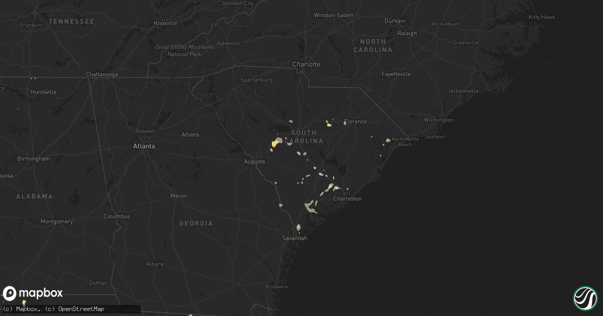
Hail Map in South Carolina on June 22, 2015
Get this storm
June 22 map
$229
one time, instant access
Download today. No call, no setup
Keep the $229
Bought the map and want the full workflow? Apply the entire $229 to a subscription within 7 days. None of it is wasted.
Every map, not just this one
This buys you this map. Subscription and you get every map we run, in the markets you choose from a few cities to whole states to nationwide. Plus real-time alerts the moment a storm fires.
Contact data
Name, contact info, occupancy, even credit band for addresses in the footprint. You go from where it hit to who to call.
Become the source they trust
Unlimited branding weather history reports on demand. You already have the documented answer ready for the property owner, and you are the one who showed up with it.
Property data and RoofTrace estimates
Pull up any address you have got, its value and the exact code rules for that jurisdiction, straight from One Click Code. Then RoofTrace estimates the squares, pitch, and roof value, priced the way you price.
Storm reports in South Carolina
South Carolina
| Date | Description |
|---|---|
| 06/22/20156:46 PM CDT | Warning point reported tree down at the 2900 block of combahee road. |
| 06/22/20156:25 PM CDT | Highway patrol reported tree down at the intersection of green pond highway and wisteria road. |
| 06/22/20155:50 PM CDT | A trained spotter relayed pictures through twitter of one large tree uprooted...another snapped off...and one large limb down off new riverside road. Time estimated by |
| 06/22/20155:17 PM CDT | Public reported shingles blown off of a roof and two porches with the roofs blown off along jamestown road. Based on the damage the estimated wind speed ranged from 70 |
| 06/22/20155:15 PM CDT | Public reported quarter sized hail with estimated winds from 60 to 70 mph on highway 441. |
| 06/22/20155:15 PM CDT | Public reported winds estimated from 60 to 70 mph. The strong winds blew lawn furniture and other backyard objects into the woods behind the house. |
| 06/22/20155:10 PM CDT | Public report of trees down on property. Wind estimated at 60 mph. 0.80 inches of rain. |
| 06/22/20154:50 PM CDT | Several large tree limbs blown down near cummings chapel. |
| 06/22/20154:45 PM CDT | Quarter sized hail. |
| 06/22/20154:45 PM CDT | Trees down on old trolley road near savannah road. Also a large branch down on a power line |
| 06/22/20154:43 PM CDT | A local report indicates 1.00 inch wind near 4 S SUMMERVILLE |
| 06/22/20154:36 PM CDT | Relaying a report from the fire department of a very large tree down. Also reports hail the size of marbles. |
| 06/22/20154:21 PM CDT | Trees down near north little river rd |
| 06/22/20154:11 PM CDT | Tree down at the intersection of short cut road and st. Paul road. |
| 06/22/20154:05 PM CDT | Report of several trees and large limbs down along with roof damage to an old barn along oakridge rd near the intersection of earle rd |
| 06/22/20154:03 PM CDT | Tree down near the intersection of i-26 and sc 453. |
| 06/22/20154:00 PM CDT | Sheriff report several trees down at blackville road and meadowfield road |
| 06/22/20153:59 PM CDT | Sc highway patrol reported trees down bull swamp road and ireland drive northeast of the town of north. |
| 06/22/20153:51 PM CDT | Skywarn spotter reported trees down in north. Wind gust measured at 55 mph. |
| 06/22/20153:51 PM CDT | Trees down on hwy 601s. Time estimated by radar. |
| 06/22/20153:51 PM CDT | Skywarn spotter reported trees down in north. Wind gust measured at 55 mph. |
| 06/22/20153:44 PM CDT | Lexington county dot reported trees down along juniper spring road near two notch road. Public also reported large limbs down in gilbert via social media. |
| 06/22/20153:25 PM CDT | Sc highway patrol reported trees down on us301 at us 21 in downtown orangeburg. |
| 06/22/20153:23 PM CDT | Skywarn spotter reported 1.5 to 1.75 inch hail on uncle duck road |
| 06/22/20153:22 PM CDT | Tree down at santee river rd and von hollen rd. Time estimated by radar. |
| 06/22/20152:25 PM CDT | Sc dot reports trees down along stafford road. Time estimated on radar. |
| 06/22/20152:15 PM CDT | Quarter size hail reported off of hwy 378. |
| 06/22/20152:05 PM CDT | Quarter size hail reported off of hwy 378. |
| 06/21/20157:28 PM CDT | Tree down at broad river blvd and ice house rd. Time estimated by radar. |
All States Impacted by Hail Map on June 22, 2015
Cities Impacted by Hail Map on June 22, 2015
- Gardner, IL
- Bronson, IA
- Salix, IA
- Trenton, NC
- Bowman, SC
- Potosi, WI
- Platteville, WI
- Cuba City, WI
- Dickeyville, WI
- Hazel Green, WI
- Hiawatha, IA
- Cedar Rapids, IA
- Toddville, IA
- Palo, IA
- Marion, IA
- Robins, IA
- Shellsburg, IA
- Rockwell City, IA
- Jolley, IA
- Ely, IA
- Springer, NM
- Maxwell, NM
- Raton, NM
- Central City, IA
- Springport, MI
- Albion, MI
- Bellevue, MI
- Marshall, MI
- Olivet, MI
- Battle Creek, MI
- La Porte City, IA
- Waterloo, IA
- Alta Vista, IA
- Ossian, IA
- West Union, IA
- Lancaster, WI
- Saint Augustine, FL
- Nashville, MI
- Las Vegas, NM
- San Jose, NM
- Cedar Falls, IA
- Mentor, OH
- Mendota, IL
- Earlville, IL
- Live Oak, FL
- Madison, FL
- Williams, IA
- Pomeroy, IA
- Webster City, IA
- Somers, IA
- Moorland, IA
- Manson, IA
- Barnum, IA
- Palmer, IA
- Lytton, IA
- Galt, IA
- Vincent, IA
- Humboldt, IA
- Fort Dodge, IA
- Thor, IA
- Dows, IA
- Clarion, IA
- Duncombe, IA
- Alden, IA
- Blairsburg, IA
- Sac City, IA
- Gilmore City, IA
- Woolstock, IA
- Badger, IA
- Eagle Grove, IA
- Fonda, IA
- Clare, IA
- Goldfield, IA
- Postville, IA
- Waukon, IA
- Bloomingdale, GA
- Savannah, GA
- Braidwood, IL
- Wilmington, IL
- Swainsboro, GA
- Humphreys, MO
- Patrick Springs, VA
- Bassett, VA
- Stuart, VA
- Bell, FL
- Branford, FL
- Punta Gorda, FL
- Arcadia, FL
- South Haven, MI
- Sumner, GA
- Ty Ty, GA
- Bosworth, MO
- Keosauqua, IA
- Milton, IA
- Udell, IA
- Bonaparte, IA
- Bloomfield, IA
- Moravia, IA
- Unionville, IA
- Moulton, IA
- Cantril, IA
- Drakesville, IA
- Pulaski, IA
- Memphis, MO
- Mount Sterling, IA
- Arbela, MO
- McGregor, IA
- Marquette, IA
- Lawler, IA
- New Hampton, IA
- Elma, IA
- Calmar, IA
- Fort Atkinson, IA
- Waucoma, IA
- Deerfield, MI
- Dundee, MI
- Petersburg, MI
- Deckerville, MI
- Carsonville, MI
- Alexander, IA
- Thornton, IA
- Rensselaer, IN
- Gorin, MO
- Rembrandt, IA
- Marathon, IA
- Sioux Rapids, IA
- Albert City, IA
- Linn Grove, IA
- Reynolds, IL
- Taylor Ridge, IL
- Dalzell, SC
- Bishopville, SC
- Rembert, SC
- Sumter, SC
- La Moille, IL
- Harmon, IL
- Dixon, IL
- Ohio, IL
- Sublette, IL
- Amboy, IL
- Newell, IA
- Linesville, PA
- Conneautville, PA
- Meadville, PA
- Conneaut Lake, PA
- Soperton, GA
- Dunnellon, FL
- Coggon, IA
- Hopkinton, IA
- Monticello, IA
- Ryan, IA
- Ashburn, GA
- Naples, FL
- Fairfax, IA
- Girard, GA
- Sardis, GA
- Prairie Du Chien, WI
- Sheffield, IL
- White Oak, GA
- Waverly, GA
- Hamilton, IA
- Albia, IA
- Lovilia, IA
- Knoxville, IA
- Steuben, WI
- Wauzeka, WI
- Boscobel, WI
- Kirksville, MO
- La Plata, MO
- Elmer, MO
- Hephzibah, GA
- Blythe, GA
- Clyde, OH
- Castalia, OH
- Vickery, OH
- Serafina, NM
- Ribera, NM
- Dublin, GA
- North, SC
- Centerville, IA
- Blakesburg, IA
- Farmington, IA
- Luray, MO
- Seneca, IL
- Marseilles, IL
- Dorchester, SC
- Harleyville, SC
- Milan, MO
- Gladbrook, IA
- Beaman, IA
- Adel, GA
- Clifton, TN
- Bath Springs, TN
- Morris, IL
- Elwood, IL
- Coal City, IL
- Channahon, IL
- Minooka, IL
- Atlanta, MO
- Summerville, SC
- Nichols, IA
- Port Charlotte, FL
- Decorah, IA
- Sauk City, WI
- Mazomanie, WI
- Guttenberg, IA
- Holy Cross, IA
- Cassville, WI
- Axis, AL
- Estill, SC
- Citronelle, AL
- Trenton, FL
- Youngstown, FL
- Denison, IA
- Dundee, IA
- Aurora, IA
- Lamont, IA
- Strawberry Point, IA
- Deford, MI
- Cass City, MI
- Morrison, IL
- Rock Falls, IL
- Fulton, IL
- Sterling, IL
- Chadwick, IL
- Ridgeville, SC
- Hahira, GA
- Nashville, GA
- Ray City, GA
- Clarendon, NC
- Chadbourn, NC
- Milton, FL
- Greenville, FL
- Baring, MO
- Ubly, MI
- Royal Center, IN
- Montville, OH
- Chardon, OH
- Charles City, IA
- Pemberville, OH
- Bowling Green, OH
- Conway, SC
- Manchester, IA
- Winthrop, IA
- Masonville, IA
- Winnsboro, SC
- Ladson, SC
- Wyoming, IA
- Onslow, IA
- Northfield, OH
- Bedford, OH
- Macedonia, OH
- Lisbon, IA
- Mount Vernon, IA
- Stanwood, IA
- Olin, IA
- Mechanicsville, IA
- Momence, IL
- Pembroke Township, IL
- Belmond, IA
- Kanawha, IA
- Monetta, SC
- Batesburg, SC
- Manteno, IL
- Jesup, GA
- Alta, IA
- Storm Lake, IA
- Ardmore, AL
- Bennett, IA
- Martinsville, VA
- Elkader, IA
- Farmersburg, IA
- Luana, IA
- Saint Olaf, IA
- Monona, IA
- Elgin, IA
- Cherokee, IA
- Marcus, IA
- Quimby, IA
- Varina, IA
- Aurelia, IA
- Correctionville, IA
- Pocahontas, IA
- Washta, IA
- Pierson, IA
- West Farmington, OH
- Crawfordville, FL
- Lansing, IA
- Eldora, IA
- Iowa Falls, IA
- Clarksville, IA
- Tripoli, IA
- Waverly, IA
- Sheridan, IL
- Serena, IL
- Ottawa, IL
- Promise City, IA
- Wray, GA
- Interlachen, FL
- East Dubuque, IL
- Wiggins, MS
- Curlew, IA
- Avoca, WI
- Woodman, WI
- Bagley, WI
- Lone Rock, WI
- Richland Center, WI
- Mount Hope, WI
- Highland, WI
- Gays Mills, WI
- Muscoda, WI
- Blue River, WI
- Garnavillo, IA
- Martelle, IA
- Anamosa, IA
- Grand Ridge, IL
- Ida, MI
- Bloomington, WI
- Center Junction, IA
- Green City, MO
- Ruthven, IA
- Dickens, IA
- Mazon, IL
- Citra, FL
- Fort McCoy, FL
- Anthony, FL
- Oregon, IL
- Franklin Grove, IL
- Bangor, MI
- Arabi, GA
- Cordele, GA
- Attica, MI
- Lapeer, MI
- Wheatland, IA
- Calamus, IA
- Sanderson, FL
- Imlay City, MI
- Sioux City, IA
- Chiefland, FL
- Cove City, NC
- Carriere, MS
- Poplarville, MS
- Seymour, IA
- Corydon, IA
- Orchard, IA
- Osage, IA
- Whiteville, NC
- Astor, FL
- Sandusky, OH
- Port Clinton, OH
- Mobile, AL
- Saraland, AL
- Muscatine, IA
- Lyndon, IL
- Hazleton, IA
- Jesup, IA
- Independence, IA
- Dunkerton, IA
- Oelwein, IA
- Fairbank, IA
- Rolfe, IA
- Arena, WI
- Spring Green, WI
- Lodge, SC
- Traer, IA
- Conrad, IA
- Liscomb, IA
- Novinger, MO
- Cleveland, OH
- Clinton, IA
- Sumner, IA
- Naylor, GA
- New Boston, MO
- Winigan, MO
- Linneus, MO
- Livonia, MO
- Browning, MO
- Purdin, MO
- Bucklin, MO
- Unionville, MO
- Green Castle, MO
- Cincinnati, IA
- Worthington, MO
- Brookfield, MO
- Jacksonville, FL
- Kankakee, IL
- Bourbonnais, IL
- Grant Park, IL
- Collinsville, VA
- Fieldale, VA
- Macon, MO
- Bevier, MO
- McAlpin, FL
- Wellborn, FL
- Bethel Springs, TN
- Selmer, TN
- Orangeburg, SC
- Saint Matthews, SC
- Webb, IA
- Moss Point, MS
- Mount Auburn, IA
- Corinth, MS
- Baxley, GA
- Eastman, WI
- Waterville, IA
- Ferryville, WI
- Harpers Ferry, IA
- Hartford, WI
- Dexter, MI
- Ann Arbor, MI
- Buckingham, IA
- Havelock, IA
- Worthington, IA
- Cascade, IA
- Britton, MI
- La Motte, IA
- Dubuque, IA
- Bellevue, IA
- Galena, IL
- Scales Mound, IL
- Garrettsville, OH
- Southington, OH
- Atkins, IA
- Grand Bay, AL
- Eight Mile, AL
- Lumpkin, GA
- Goose Lake, IA
- Prophetstown, IL
- Thomson, IL
- Welton, IA
- Charlotte, IA
- Lost Nation, IA
- De Witt, IA
- Eldena, IL
- Delmar, IA
- Grand Mound, IA
- Bryant, IA
- Sabula, IA
- Walnut, IL
- Tennille, GA
- Francesville, IN
- Plainfield, IA
- Marceline, MO
- Exline, IA
- Ethel, MO
- New Cambria, MO
- Glenwood, MO
- Pollock, MO
- Coatsville, MO
- Livingston, AL
- Jacksonville, MO
- Excello, MO
- Cairo, MO
- Birch Run, MI
- Saginaw, MI
- Okatie, SC
- Vinton, IA
- Alburnett, IA
- Indianola, IA
- Ackworth, IA
- Georgetown, SC
- Fort Stewart, GA
- Sparks, GA
- Adrian, GA
- Downing, MO
- Otsego, MI
- Gobles, MI
- Kalamazoo, MI
- Plainwell, MI
- Spragueville, IA
- Maquoketa, IA
- Camilla, GA
- Newton, GA
- Aiken, SC
- Gresham, SC
- Melcher Dallas, IA
- Chariton, IA
- Melrose, IA
- Columbia, IA
- Lacona, IA
- Middleton, TN
- Newington, GA
- Ehrhardt, SC
- Springville, IA
- Center Point, IA
- Morley, IA
- Stockton, GA
- Ridgeway, IA
- Cimarron, NM
- Emmetsburg, IA
- Leesville, SC
- Grand Junction, MI
- Bloomingdale, MI
- Allegan, MI
- Rutledge, MO
- Buckingham, IL
- Reddick, IL
- Castalia, IA
- Laclede, MO
- Meadville, MO
- Sumner, MO
- Keystone Heights, FL
- Florahome, FL
- Hardeeville, SC
- Ludowici, GA
- Glen Saint Mary, FL
- Timmonsville, SC
- Lamar, SC
- Cashiers, NC
- Sapphire, NC
- Perrysburg, OH
- Port Wentworth, GA
- Saint Charles, MI
- Merrill, MI
- Greene, IA
- Lone Tree, IA
- Riceboro, GA
- Midway, GA
- Saint George, SC
- Maybee, MI
- Andrew, IA
- Carrollton, MO
- Candler, NC
- Readlyn, IA
- Oran, IA
- Otho, IA
- Preston, IA
- Miles, IA
- Morocco, IN
- Fair Oaks, IN
- Goose Creek, SC
- Waycross, GA
- Franklinton, LA
- Monon, IN
- Fargo, GA
- Lexington, SC
- Pullman, MI
- Fennville, MI
- Augusta, GA
- Martin, MI
- Flushing, MI
- Corunna, MI
- New Lothrop, MI
- Seville, FL
- Crescent City, FL
- Flomaton, AL
- Grand Rapids, OH
- Bluffton, SC
- Delhi, IA
- Jackson, TN
- Beech Bluff, TN
- McDavid, FL
- Chillicothe, MO
- Utica, IL
- South Wilmington, IL
- Bonfield, IL
- Verona, IL
- Newark, IL
- Union Hill, IL
- Wedron, IL
- Braceville, IL
- Kinsman, IL
- Essex, IL
- Dwight, IL
- Herscher, IL
- Queen City, MO
- Greentop, MO
- Round O, SC
- Goodell, IA
- Walker, IA
- Tipton, IA
- New Liberty, IA
- Dixon, IA
- Erie, MI
- La Salle, MI
- Huron, TN
- Lexington, TN
- Vulcan, MI
- Iron Mountain, MI
- Iuka, MS
- La Salle, IL
- Peru, IL
- Plano, IA
- Westgate, IA
- Denver, IA
- Janesville, IA
- Holstein, IA
- Cushing, IA
- Juneau, WI
- Cape Coral, FL
- Bridgeport, MI
- Whiteville, TN
- Stanton, TN
- Brunswick, GA
- Decaturville, TN
- Jasper, FL
- Brashear, MO
- Hurdland, MO
- Parma, MI
- Scranton, IA
- Jefferson, IA
- Hinesville, GA
- Green Cove Springs, FL
- Hornick, IA
- Callao, MO
- Allison, IA
- Evansdale, IA
- Raymond, IA
- Stanley, IA
- Dewar, IA
- Panama City, FL
- Perkinston, MS
- Sheffield, IA
- Earlville, IA
- Edgewood, IA
- New Vienna, IA
- Greeley, IA
- Dyersville, IA
- Sutherland, IA
- Larrabee, IA
- Peterson, IA
- Paullina, IA
- Twinsburg, OH
- Goodells, MI
- Wheeling, MO
- Picayune, MS
- Logansport, IN
- Newhall, IA
- Clarence, IA
- Garrison, IA
- Lowden, IA
- Hale, MO
- Laurens, IA
- Hampton, IA
- Holly Hill, SC
- Rebecca, GA
- Monticello, FL
- Riceville, IA
- Alamo, GA
- Mendon, MO
- Lake Village, IN
- Klemme, IA
- Garner, IA
- Rowley, IA
- Brandon, IA
- Green Pond, SC
- Yemassee, SC
- Sheldon, SC
- Seabrook, SC
- Perry, MI
- Owosso, MI
- Morrice, MI
- Laingsburg, MI
- Pascagoula, MS
- Oxford Junction, IA
- Watkins, IA
- Prairieburg, IA
- Solon, IA
- Van Horne, IA
- Middlefield, OH
- Mantua, OH
- Burton, OH
- Hiram, OH
- Hallsboro, NC
- Lakeside Marblehead, OH
- Ackley, IA
- Augusta, MI
- Richland, MI
- Delton, MI
- Hickory Corners, MI
- Baker, LA
- Lucedale, MS
- Independence, OH
- Maple Heights, OH
- Beachwood, OH
- Sale City, GA
- Martin, SC
- Branchville, SC
- Smoaks, SC
- Fairmount City, PA
- Mayport, PA
- Summerville, PA
- Beaverville, IL
- Watertown, WI
- Brunswick, MO
- Sandersville, GA
- Wellsburg, IA
- Austinville, IA
- Geneva, IA
- Aplington, IA
- Garfield, GA
- Statesboro, GA
- Millen, GA
- Solon, OH
- Chula, MO
- Ponce De Leon, FL
- Delphi, IN
- Camden, IN
- Middle Bass, OH
- Put In Bay, OH
- Fulton, MO
- Moultrie, GA
- Sunfield, MI
- Mulliken, MI
- Grand Ledge, MI
- Memphis, MI
- Emmett, MI
- Capac, MI
- Allenton, MI
- Fort Myers, FL
- Euclid, OH
- Wickliffe, OH
- Eastlake, OH
- Sheffield Lake, OH
- Avon Lake, OH
- Kelleys Island, OH
- Bay Village, OH
- Medon, TN
- Milan, IL
- Altha, FL
- Clarksville, FL
- Russell, IA
- Pooler, GA
- Rincon, GA
- Chagrin Falls, OH
- Burnsville, MS
- Fleming, GA
- Milo, IA
- Pleasantville, IA
- Latimer, IA
- South Lyon, MI
- Northville, MI
- Plymouth, MI
- Cosby, MO
- Mount Morris, MI
- Cambridge, IL
- Fitzgerald, GA
- Allerton, IA
- Mystic, IA
- Avon, OH
- Olmsted Falls, OH
- North Olmsted, OH
- North Ridgeville, OH
- Westlake, OH
- Manilla, IA
- Manning, IA
- Melrose, FL
- Clinton, MI
- Saline, MI
- Manchester, MI
- Wewahitchka, FL
- Franklin, NC
- Rives Junction, MI
- Jackson, MI
- Pinetta, FL
- Lee, FL
- Gilbert, SC
- Zwingle, IA
- Grundy Center, IA
- Holland, IA
- Millington, MI
- Mallard, IA
- De Witt, MO
- Triplett, MO
- Rothville, MO
- Knox City, MO
- Garber, IA
- Colesburg, IA
- Glen Haven, WI
- Arlington, IA
- Reinbeck, IA
- Montgomery City, MO
- Valdosta, GA
- Carleton, MI
- Newport, MI
- Pelion, SC
- Gaston, SC
- Danville, AL
- Dike, IA
- Collins, GA
- Morriston, FL
- Union, IA
- Peosta, IA
- Durango, IA
- Benton, WI
- Farley, IA
- Epworth, IA
- Kieler, WI
- Sherrill, IA
- Jennings, FL
- Steamboat Rock, IA
- Sherrard, IL
- Lynn Center, IL
- Orion, IL
- Canton, NC
- Langworthy, IA
- Shell Rock, IA
- Cottageville, SC
- Winamac, IN
- Mayville, WI
- Iron Ridge, WI
- Robertsdale, AL
- Burnettsville, IN
- Idaville, IN
- Meadows Of Dan, VA
- Ararat, VA
- Tallahassee, FL
- Rowan, IA
- Shelbyville, MO
- Lentner, MO
- Shelbina, MO
- Alma, GA
- Barnett, MO
- Waverly, TN
- Middleburg, FL
- Flint, MI
- Saint Anne, IL
- Gates Mills, OH
- Saint Johns, MI
- Dewitt, MI
- Elkmont, AL
- Bogard, MO
- Camden, SC
- Harrogate, TN
- Tazewell, TN
- Somerville, TN
- Ypsilanti, MI
- Volga, IA
- Nora Springs, IA
- Rudd, IA
- Floyd, IA
- McIntire, IA
- Le Roy, MN
- Stacyville, IA
- Chester, IA
- Cresco, IA
- Wadena, IA
- Emmons, MN
- Lyle, MN
- Austin, MN
- Albert Lea, MN
- Alden, MN
- Rose Creek, MN
- Twin Lakes, MN
- Glenville, MN
- Hayward, MN
- Hollandale, MN
- Blooming Prairie, MN
- Waltham, MN
- Hayfield, MN
- Madelia, MN
- Lewisville, MN
- Mapleton, MN
- Wells, MN
- Ellendale, MN
- Janesville, MN
- Waldorf, MN
- Waseca, MN
- New Richland, MN
- Minnesota Lake, MN
- Lakeville, MN
- Elko New Market, MN
- Webster, MN
- Farmington, MN
- Lonsdale, MN
- Northfield, MN
- Good Thunder, MN
- Kilkenny, MN
- Montgomery, MN
- Elysian, MN
- Waterville, MN
- Fertile, IA
- Woden, IA
- Kensett, IA
- Joice, IA
- Lake Mills, IA
- Britt, IA
- Buffalo Center, IA
- Hanlontown, IA
- Forest City, IA


