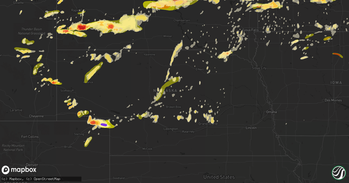
Hail Map in Nebraska on June 21, 2013
Get this storm
June 21 map
$229
one time, instant access
Download today. No call, no setup
Keep the $229
Bought the map and want the full workflow? Apply the entire $229 to a subscription within 7 days. None of it is wasted.
Every map, not just this one
This buys you this map. Subscription and you get every map we run, in the markets you choose from a few cities to whole states to nationwide. Plus real-time alerts the moment a storm fires.
Contact data
Name, contact info, occupancy, even credit band for addresses in the footprint. You go from where it hit to who to call.
Become the source they trust
Unlimited branding weather history reports on demand. You already have the documented answer ready for the property owner, and you are the one who showed up with it.
Property data and RoofTrace estimates
Pull up any address you have got, its value and the exact code rules for that jurisdiction, straight from One Click Code. Then RoofTrace estimates the squares, pitch, and roof value, priced the way you price.
Storm reports in Nebraska
Nebraska
| Date | Description |
|---|---|
| 06/21/20136:31 PM CDT | 6 power poles were pulled out of the ground. A center pivot with 4 towers was damaged. Corn was pulled out of a field. |
| 06/21/20136:24 PM CDT | A local report indicates 1.00 inch wind near 5 SE CHAPPELL |
| 06/21/20136:00 PM CDT | A local report indicates 60 MPH wind near 24 N ANTIOCH |
| 06/21/20135:10 PM CDT | A local report indicates 1.75 inch wind near 10 NE KIMBALL |
| 06/21/20135:01 PM CDT | A local report indicates a tornado near 5 N SIDNEY |
| 06/21/20134:57 PM CDT | Observed along interstate 80. |
| 06/21/20134:45 PM CDT | A local report indicates 1.75 inch wind near 10 SW LODGEPOLE |
| 06/21/20134:33 PM CDT | Pea to golfball sized hail. Mile marker 48 of highway 30. |
| 06/21/20134:32 PM CDT | Trained spotter reported marble to quarter sized hail |
| 06/21/20134:26 PM CDT | A local report indicates 2.75 inch wind near 9 E HARRISBURG |
| 06/21/20134:01 PM CDT | Trained spotter reported a tornado on the ground south of potter and interstate 80. Tornado was moving slightly west of due north. |
| 06/21/20134:00 PM CDT | A local report indicates 1.00 inch wind near HARRISBURG |
| 06/21/20133:51 PM CDT | North part of sidney city limits. Relayed from cheyenne county warning point. |
| 06/21/20133:36 PM CDT | A local report indicates 1.00 inch wind near 4 W SIDNEY |
| 06/21/20133:33 PM CDT | A local report indicates 1.00 inch wind near 1 W SIDNEY |
| 06/20/201311:14 PM CDT | Valley county emergency manager reports tree limbs down in arcadia at 4 inches and smaller. |
| 06/20/201311:00 PM CDT | 63 mph wind gust recorded by automated equipment at ord airport. This is is addition to earlier gust at 1050pm of same magntidue. |
| 06/20/201311:00 PM CDT | Winds estimated to 70 mph with power out in broken bow. Additional wind damage includes tree damage and an overturned center pivot in the comstock area. Wind damage rep |
| 06/20/201311:00 PM CDT | Emergency manager called in winds estimated to 70 mph. |
| 06/20/201311:00 PM CDT | Valley county emergency manager reports tree limbs down in arcadia at 4 inches and smaller. Time adjusted earlier from original report based on radar data. |
| 06/20/201310:50 PM CDT | Wind gust measured by automated system at ord airport. |
| 06/20/201310:45 PM CDT | A machine shed located approximately 11 miles west and 1 mile north of ord was destroyed. From there to approximately 4 miles west of ord...a number of power poles were |
| 06/20/201310:19 PM CDT | Numerous trees down in broken bow...estimated wind gusts in excess of 70 mph. |
| 06/20/201310:15 PM CDT | Garage is destroyed with the roof being blown an estimated 50 yards away. Trees were bent to the ground. |
| 06/20/201310:15 PM CDT | Large trees and power lines were knocked down. Roofs were blown off buildings with one roof an estimated 30 to 40 yards away. Time is estimated |
| 06/20/201310:10 PM CDT | A large tree limb was broken off. Time is estimated by radar. |
| 06/20/20139:51 PM CDT | Measured outflow in advance of the storm. |
| 06/20/20139:50 PM CDT | Trained spotter reported 60 mph gust measured on dawson county lincoln county line. |
| 06/20/20139:50 PM CDT | Public report of winds at 45 mph gusting to 60 mph in gothenburg. |
| 06/20/20139:30 PM CDT | Time is estimated by radar. |
| 06/20/20139:23 PM CDT | Mostly pea to dime size. |
| 06/20/20139:05 PM CDT | A local report indicates 1.00 inch wind near W NORTH PLATTE |
| 06/20/20138:45 PM CDT | A local report indicates 1.00 inch wind near HERSHEY |
| 06/20/20138:41 PM CDT | A local report indicates 60 MPH wind near SUTHERLAND |
| 06/20/20138:17 PM CDT | A local report indicates 1.00 inch wind near 6 E PAXTON |
| 06/20/20137:30 PM CDT | Event duration 30 minutes. |
| 06/20/20137:25 PM CDT | Power poles down...estimated wind gusts to 70 mph. |
| 06/20/20137:15 PM CDT | Nickel size hail was also reported |
All States Impacted by Hail Map on June 21, 2013
Cities Impacted by Hail Map on June 21, 2013
- Goodwin, SD
- Clear Lake, SD
- Bellingham, MN
- Madison, MN
- Revillo, SD
- Gary, SD
- Marietta, MN
- Bassett, NE
- Spencer, NE
- Bristow, NE
- Castlewood, SD
- Watertown, SD
- Hazel, SD
- Litchfield, NE
- Ravenna, NE
- Pleasanton, NE
- Hazard, NE
- Eyota, MN
- Rochester, MN
- Granite Falls, MN
- Clinton, MN
- Odessa, MN
- Morris, MN
- Corona, SD
- Chokio, MN
- Ortonville, MN
- Big Stone City, SD
- Correll, MN
- Appleton, MN
- Milbank, SD
- Alberta, MN
- Tatum, NM
- Crossroads, NM
- Dyer, IN
- Saint John, IN
- New Glarus, WI
- Belleville, WI
- Eunice, NM
- Texico, NM
- Grady, NM
- Bovina, TX
- Sidney, NE
- Lindsay, NE
- Madison, SD
- Douglas, WY
- Tyler, MN
- Ruthton, MN
- Lake Benton, MN
- Balaton, MN
- Russell, MN
- Holland, MN
- Caledonia, MN
- Spring Grove, MN
- Eitzen, MN
- Armstrong, IA
- Dolliver, IA
- Estherville, IA
- Fairburn, SD
- Buffalo Gap, SD
- Pine Ridge, SD
- Marshall, MN
- Greeley, NE
- Newcastle, WY
- Harrisburg, NE
- Darlington, WI
- Fleming, CO
- Otis, CO
- Fort Pierre, SD
- Littlefield, TX
- Bridgewater, SD
- Emery, SD
- Herrick, SD
- Saint Charles, SD
- Bonesteel, SD
- Mason City, NE
- Broken Bow, NE
- Oconto, NE
- Sumner, NE
- Sherburn, MN
- Rushville, NE
- Miller, SD
- Saint Lawrence, SD
- Kiester, MN
- Bricelyn, MN
- Wells, MN
- Utica, SD
- Elgin, IA
- Wadena, IA
- Potter, NE
- Gurley, NE
- Delavan, IL
- Hopedale, IL
- Lancaster, WI
- Fennimore, WI
- Woodman, WI
- Wauzeka, WI
- Boscobel, WI
- Mount Hope, WI
- Highmore, SD
- Belle Fourche, SD
- Aladdin, WY
- Sundance, WY
- Newell, SD
- Wanblee, SD
- Interior, SD
- Spencer, IA
- Dickens, IA
- Terril, IA
- Benson, MN
- Garnavillo, IA
- Gibbon, MN
- Brodhead, WI
- Evansville, WI
- Orfordville, WI
- Cohagen, MT
- Tampa, FL
- Willow Lake, SD
- Slayton, MN
- Tracy, MN
- Garvin, MN
- Jasper, MN
- Spearfish, SD
- Lead, SD
- Springfield, IL
- Sherman, IL
- Torrington, WY
- Dodgeville, WI
- Mineral Point, WI
- Springview, NE
- Long Pine, NE
- Lewis, IN
- Clay City, IN
- Custer, SD
- Dana, IN
- Chrisman, IL
- Loup City, NE
- La Porte City, IA
- Orlando, FL
- Maitland, FL
- Winter Park, FL
- Le Sueur, MN
- Cleveland, MN
- Madison Lake, MN
- Saint Peter, MN
- Kasota, MN
- Argyle, WI
- Verona, WI
- Brooklyn, WI
- Monticello, WI
- Albany, WI
- Luverne, MN
- Steen, MN
- Denver City, TX
- Plains, TX
- Seminole, TX
- Alexander, ND
- Tulare, SD
- Presho, SD
- Lingle, WY
- Buffalo Center, IA
- Ledyard, IA
- Elmore, MN
- Swea City, IA
- Watford City, ND
- Bryant, SD
- Clark, SD
- Carpenter, SD
- De Smet, SD
- Frankfort, SD
- Doland, SD
- Raymond, SD
- Vienna, SD
- Hitchcock, SD
- Redfield, SD
- Mcalister, NM
- Tucumcari, NM
- Harrold, SD
- Iona, MN
- Clements, MN
- Reading, MN
- Rushmore, MN
- Wilmont, MN
- Monticello, IA
- Langworthy, IA
- Amboy, IL
- Dover, IL
- La Moille, IL
- Princeton, IL
- Ohio, IL
- Bradford, IL
- Tiskilwa, IL
- Malden, IL
- Van Orin, IL
- Sublette, IL
- Saint Paul, NE
- Palmer, NE
- Covington, IN
- Perrysville, IN
- Cayuga, IN
- Kingman, IN
- Crofton, NE
- Bloomfield, NE
- Apopka, FL
- Morristown, SD
- Hettinger, ND
- New Leipzig, ND
- Watauga, SD
- Carson, ND
- Lemmon, SD
- Keldron, SD
- Selfridge, ND
- Ree Heights, SD
- Coggon, IA
- Walker, IA
- Tremont, IL
- Deer Creek, IL
- Washington, IL
- Morton, IL
- Groveland, IL
- Grand Marsh, WI
- Oregon, IL
- Byron, IL
- Lake Andes, SD
- Wagner, SD
- Oldham, SD
- Arlington, SD
- Montgomery, MN
- Saint Olaf, IA
- Volga, IA
- Strawberry Point, IA
- Arlington, IA
- Elkader, IA
- Estelline, SD
- Blunt, SD
- Pierre, SD
- Oral, SD
- Hot Springs, SD
- Ivanhoe, MN
- Westville, IL
- Ewing, NE
- Chambers, NE
- Levelland, TX
- Alpine, TX
- Lost Springs, WY
- Shawnee, WY
- Canby, MN
- Murdock, MN
- Corsica, SD
- Harrison, SD
- Adrian, MN
- Magnolia, MN
- Kanaranzi, MN
- Ellsworth, MN
- Rock Rapids, IA
- Decorah, IA
- Murdo, SD
- White River, SD
- Okaton, SD
- Robins, IA
- Toddville, IA
- Marion, IA
- Cedar Rapids, IA
- Alden, MN
- New Hampton, IA
- Lance Creek, WY
- Masonville, IA
- Winthrop, IA
- Manchester, IA
- Heron Lake, MN
- Merriman, NE
- Gordon, NE
- Fort Stockton, TX
- Coyanosa, TX
- Hay Springs, NE
- Menomonie, WI
- Elk Mound, WI
- Peoria, IL
- Chillicothe, IL
- Mossville, IL
- Metamora, IL
- East Peoria, IL
- Dunlap, IL
- Monahans, TX
- Wink, TX
- Howard Lake, MN
- Waverly, MN
- Mayer, MN
- Parker, SD
- Humboldt, SD
- Chancellor, SD
- Green Valley, IL
- San Jose, IL
- Gillette, WY
- Volga, SD
- Aurora, SD
- Brookings, SD
- Cambridge, WI
- Edgerton, WI
- Fort Thompson, SD
- Wessington, SD
- Wolsey, SD
- Vivian, SD
- Holabird, SD
- Draper, SD
- Orient, SD
- Cavour, SD
- Yale, SD
- Iroquois, SD
- Stephan, SD
- Huron, SD
- Kyle, SD
- Dundee, IA
- Platte, SD
- Volin, SD
- Mission Hill, SD
- Milford, IA
- Worthington, MN
- Freeport, IL
- Baileyville, IL
- Belgrade, MN
- Norwood Young America, MN
- Hamburg, MN
- Stillman Valley, IL
- Wilson, WI
- Woodville, WI
- Baldwin, WI
- Pocahontas, IA
- Havelock, IA
- Hawkeye, IA
- Ocheyedan, IA
- Round Lake, MN
- Clarksville, IA
- Mott, ND
- Freedom, IN
- Stewart, MN
- Chadron, NE
- Seaforth, MN
- Redwood Falls, MN
- Vesta, MN
- Belview, MN
- Phillips, NE
- Chapman, NE
- Marquette, NE
- Grand Island, NE
- Milroy, MN
- Scenic, SD
- Clarkfield, MN
- Blue River, WI
- Steuben, WI
- Marquette, IA
- Farmersburg, IA
- Gays Mills, WI
- Soldiers Grove, WI
- Eastman, WI
- Harpers Ferry, IA
- McGregor, IA
- Prairie Du Chien, WI
- Bagley, WI
- Cylinder, IA
- Emmetsburg, IA
- Homosassa, FL
- Wheatland, WY
- Beloit, WI
- Tabor, SD
- Williston, ND
- Sumner, IA
- Lacon, IL
- Renville, MN
- Sacred Heart, MN
- Eagle, WI
- Elkhorn, WI
- Rochester, WI
- Palmyra, WI
- Burlington, WI
- Whitewater, WI
- Wales, WI
- Delafield, WI
- North Prairie, WI
- East Troy, WI
- Waukesha, WI
- Dousman, WI
- Oconomowoc, WI
- Mukwonago, WI
- Waterford, WI
- Glenville, MN
- Twin Lakes, MN
- Albert Lea, MN
- Norris, SD
- Belvidere, SD
- Hermosa, SD
- Long Valley, SD
- Kadoka, SD
- Mechanicsville, IA
- Midland, SD
- Edgemont, SD
- Rapid City, SD
- Box Elder, SD
- Wall, SD
- Caputa, SD
- Porcupine, SD
- Elkton, SD
- Conger, MN
- Afton, WI
- Janesville, WI
- Henry, SD
- Dallas, SD
- Mills, NE
- Gregory, SD
- Burke, SD
- Marengo, IA
- Glendo, WY
- Crook, CO
- Leland, IA
- Forest City, IA
- Osage, WY
- Ferryville, WI
- Wakonda, SD
- Irene, SD
- Washington, IN
- Burwell, NE
- Morrill, NE
- Sulphur, LA
- Regent, ND
- Page, NE
- Lena, IL
- Pearl City, IL
- Kent, IL
- Hayfield, MN
- Blooming Prairie, MN
- Stapleton, NE
- Raymond, MN
- Prinsburg, MN
- Maynard, MN
- Clara City, MN
- Sedgwick, CO
- Manville, WY
- Ashton, NE
- Ghent, MN
- Brandon, IA
- Winslow, IL
- Hill City, SD
- Alliance, NE
- Ogallala, NE
- Madrid, NE
- Grant, NE
- Julesburg, CO
- Ovid, CO
- Jay Em, WY
- Fort Laramie, WY
- Harrison, NE
- Yoder, WY
- Hanley Falls, MN
- Minneota, MN
- Taunton, MN
- Cottonwood, MN
- Howard, SD
- Harmony, MN
- Lodgepole, NE
- Echo, MN
- Hartville, WY
- Maquon, IL
- London Mills, IL
- Hudson, WI
- Ropesville, TX
- Waterville, IA
- Lakefield, MN
- Elkhart, IL
- Keene, ND
- Mchenry, IL
- Fox Lake, IL
- Spring Grove, IL
- Ringwood, IL
- Wonder Lake, IL
- Woodstock, IL
- Ingleside, IL
- Freeman, SD
- Deering, ND
- Upham, ND
- Clarks, NE
- Central City, NE
- Dix, NE
- Kimball, NE
- Bayard, NE
- Independence, IA
- Dunkerton, IA
- Fayette, IA
- Aurora, IA
- Fairbank, IA
- Hazleton, IA
- Stanley, IA
- Waterloo, IA
- Oelwein, IA
- Winnebago, IL
- Leaf River, IL
- Pecatonica, IL
- Purdum, NE
- Rudolph, WI
- Stevens Point, WI
- Durand, IL
- Arnold, NE
- Dunning, NE
- Delano, MN
- Watertown, MN
- Henry, IL
- Lowpoint, IL
- Varna, IL
- Washburn, IL
- Sparland, IL
- Hayti, SD
- Franklin Grove, IL
- Ashton, IL
- Mount Morris, IL
- Dixon, IL
- Creighton, NE
- Stuart, NE
- Springfield, MN
- Artesian, SD
- Fort Davis, TX
- Wood Lake, MN
- West Union, IA
- Moorcroft, WY
- Pyote, TX
- Hardwick, MN
- Walnut Grove, MN
- Lucan, MN
- Athens, IL
- Stoughton, WI
- Corning, IA
- Hancock, MN
- Starbuck, MN
- Hector, MN
- Buffalo, SD
- Fredericksburg, IA
- Fort Atkinson, IA
- Postville, IA
- Waukon, IA
- Lawler, IA
- Waucoma, IA
- Castalia, IA
- Clermont, IA
- Ossian, IA
- Atwater, MN
- Gotha, FL
- Ocoee, FL
- Windermere, FL
- Hopkinton, IA
- Montrose, MN
- Winsted, MN
- Monroe, WI
- Juda, WI
- Canistota, SD
- Mallard, IA
- Pipestone, MN
- Flandreau, SD
- Lake Norden, SD
- Wessington Springs, SD
- Archer, NE
- Saint Libory, NE
- Mountain Lake, MN
- Dana, IL
- De Soto, WI
- Glencoe, MN
- Ainsworth, NE
- Lake Preston, SD
- Kilkenny, MN
- Nicollet, MN
- Lafayette, MN
- Henderson, MN
- Courtland, MN
- Mankato, MN
- New Ulm, MN
- Le Center, MN
- Edgewood, IA
- Elkport, IA
- Solon, IA
- Cedar Falls, IA
- Danvers, MN
- Fullerton, NE
- Genoa, NE
- Atkinson, NE
- Paxton, NE
- South Beloit, IL
- Roscoe, IL
- Rockton, IL
- Peterson, MN
- Utica, MN
- Lanesboro, MN
- Everly, IA
- Jesup, IA
- Lamont, IA
- Wisconsin Dells, WI
- Adams, WI
- Marion, SD
- Wallace, SD
- Cresco, IA
- Ridgeway, IA
- Gillett Grove, IA
- Greenville, IA
- Crawford, NE
- Ruthven, IA
- Whittemore, IA
- Blue Earth, MN
- Imogene, IA
- Emerson, IA
- Byron, MN
- Stewartville, MN
- Esmond, IL
- Kirkland, IL
- Monroe Center, IL
- Vinton, IA
- Garrison, IA
- Muscoda, WI
- Melrose, NM
- Monroe, SD
- Chappell, NE
- Anselmo, NE
- Niobrara, NE
- Springfield, SD
- Yankton, SD
- Lester Prairie, MN
- New Germany, MN
- Hawthorne, FL
- Winnebago, MN
- Lesterville, SD
- Sibley, IA
- Tuthill, SD
- Olivia, MN
- Scotia, NE
- Elba, NE
- Menno, SD
- Hollandale, MN
- Ellendale, MN
- McConnell, IL
- North Platte, NE
- Knapp, WI
- Arnegard, ND
- Balmorhea, TX
- Fulda, MN
- Eau Claire, WI
- Altoona, WI
- Orchard, NE
- Sunburg, MN
- Edgerton, MN
- Chandler, MN
- Erwin, SD
- Bruce, SD
- Tripp, SD
- Parkston, SD
- Walworth, WI
- Morrison, IL
- Fulton, IL
- White, SD
- Hendricks, MN
- Lynd, MN
- Arco, MN
- Upton, WY
- Fairfax, MN
- Van Horne, IA
- Meadow, TX
- Quasqueton, IA
- Rowley, IA
- Plankinton, SD
- Clinton, IA
- Devils Tower, WY
- Weston, WY
- Rozet, WY
- Hulett, WY
- Hamel, MN
- Loretto, MN
- Ansley, NE
- Roberts, WI
- Holloway, MN
- Montevideo, MN
- Kerkhoven, MN
- Callaway, NE
- Lansing, IA
- Sargent, NE
- Deridder, LA
- Pine Top, KY
- Viborg, SD
- Center Point, IA
- Lanark, IL
- Shannon, IL
- Mount Carroll, IL
- Blanchardville, WI
- Palestine, IL
- Badger, SD
- Rutland, SD
- Currie, MN
- Porter, MN
- Astoria, SD
- Gann Valley, SD
- Wentworth, SD
- Colman, SD
- Strandburg, SD
- Lower Brule, SD
- Evansdale, IA
- Gainesville, FL
- Salem, SD
- Rockford, MN
- Buffalo, MN
- Maple Plain, MN
- Lake Geneva, WI
- Hebron, IL
- Morgan, MN
- Pennock, MN
- Danube, MN
- Watson, MN
- Blomkest, MN
- Clontarf, MN
- Milan, MN
- New London, MN
- Brooten, MN
- Antler, ND
- Bird Island, MN
- Farwell, NE
- Fair Oaks, IN
- Rensselaer, IN
- Gothenburg, NE
- Brady, NE
- Wolbach, NE
- Oxford, WI
- Westfield, WI
- Capron, IL
- Harvard, IL
- Jackson, MN
- Alpha, MN
- Brownfield, TX
- Wausau, WI
- Rothschild, WI
- Mosinee, WI
- Nashua, IA
- Keystone, SD
- Mount Horeb, WI
- Hutchinson, MN
- Lovington, NM
- Genoa City, WI
- Ayrshire, IA
- Fairfax, IA
- Saint Onge, SD
- West Brooklyn, IL
- Calmar, IA
- Meadow Grove, NE
- Dorchester, IA
- Bismarck, ND
- Kandiyohi, MN
- Willmar, MN
- Protivin, IA
- Terre Haute, IN
- Garber, IA
- Colesburg, IA
- Greeley, IA
- Depue, IL
- Delavan, WI
- Davis, SD
- Lennox, SD
- Twin Brooks, SD
- Leesburg, FL
- Madison, WI
- Oregon, WI
- Venango, NE
- Belle Plaine, MN
- New Prague, MN
- Crystal River, FL
- Dunnellon, FL
- Ridott, IL
- German Valley, IL
- New Holland, IL
- Mason City, IL
- Haxtun, CO
- Rolfe, IA
- Rockford, IL
- Dannebrog, NE
- Burt, IA
- Titonka, IA
- Gaylord, MN
- Avon, SD
- Big Springs, NE
- Fairmont, MN
- Alva, WY
- Graettinger, IA
- Wallingford, IA
- Long Lake, MN
- New Salem, ND
- Sleepy Eye, MN
- Milford, IL
- Forest City, IL
- Laurens, IA
- Minneapolis, MN
- Manito, IL
- Earl Park, IN
- Veedersburg, IN
- Hartley, IA
- Woden, IA
- Avoca, WI
- Williamsville, IL
- Pekin, IL
- Hartsburg, IL
- Middletown, IL
- Petersburg, IL
- Easton, IL
- Minier, IL
- Emden, IL
- Mackinaw, IL
- Greenview, IL
- Eureka, IL
- Fenton, IA
- Wabasso, MN
- South Shore, SD
- Arlington, MN
- Paris, IL
- Clinton, IN
- Shullsburg, WI
- Livingston, WI
- Platteville, WI
- Chatfield, MN
- Canova, SD
- Pecos, TX
- Montrose, SD
- Racine, WI
- Johnson City, TN
- Dante, SD
- Brunswick, NE
- Union Grove, WI
- Kansasville, WI
- Fountain, MN
- Spring Valley, MN
- Wykoff, MN
- Preston, MN
- Greene, IA
- Guttenberg, IA
- Hershey, NE
- Bayport, MN
- Stillwater, MN
- Revere, MN
- Lamberton, MN
- Kenneth, MN
- Trimont, MN
- Saint Francis, SD
- Flat Rock, IL
- Sinai, SD
- Fall Creek, WI
- Cherry Valley, IL
- Davis Junction, IL
- Robinson, IL
- Lake Mills, WI
- Boswell, IN
- Readlyn, IA
- Lake Lillian, MN
- Lake Park, IA
- Curlew, IA
- Winthrop, MN
- Saint Paul, MN
- Lake Elmo, MN
- Woodstock, MN
- Ringsted, IA
- Hurley, SD
- Brule, NE
- Georgetown, IL
- Danville, IL
- Fort Atkinson, WI
- Belmont, WI
- Forreston, IL
- Polo, IL
- Mitchell, SD
- Dunnell, MN
- Shirland, IL
- Chana, IL
- Clinton, WI
- Eldena, IL
- Rock City, IL
- Footville, WI
- Cottage Grove, WI
- Machesney Park, IL
- Caledonia, IL
- Mcfarland, WI
- Deerfield, WI
- Poplar Grove, IL
- Marshall, WI
- Davis, IL
- Maxwell, NE
- Sioux Center, IA
- Orange City, IA
- Hull, IA
- Boyden, IA
- Veteran, WY
- Sullivan, IN
- Fairbanks, IN
- Moss Point, MS
- Tryon, NE
- Dawson, IL
- Lynch, NE
- Oneill, NE
- Denver, IA
- Osseo, MN
- Ramona, SD
- Nunda, SD
- Cantrall, IL
- Tyndall, SD
- Dane, WI
- Waunakee, WI
- Clare, IL
- Centerville, SD
- Newhall, IA
- Viroqua, WI
- Saint Edward, NE
- Colton, SD
- Palo, IA
- Grand Bay, AL
- Cody, NE
- Milledgeville, IL
- Bison, SD
- Meadow, SD
- Scarville, IA
- Easton, MN
- Lake Mills, IA
- Frost, MN
- Emmons, MN
- Whitney, NE
- Elgin, ND
- Richland Center, WI
- Theodore, AL
- Geddes, SD
- Boyd, MN
- Sycamore, IL
- Dekalb, IL
- Umatilla, FL
- Delhi, IA
- Earlville, IA
- Anamosa, IA
- Ridge Farm, IL
- Montezuma, IN
- Hillsdale, IN
- Merom, IN
- Sturtevant, WI
- Dassel, MN
- Cokato, MN
- Sidney, MT
- Allison, IA
- Mount Auburn, IA
- Bradley, SD
- Rochelle, IL
- Ord, NE
- Primghar, IA
- Sanborn, IA
- Gilbertville, IA
- Hutsonville, IL
- Neshkoro, WI
- Fairfax, SD
- Sutherland, NE
- Toronto, SD
- Elysian, MN
- Hollandale, WI
- Brewster, NE
- Cosby, TN
- Okabena, MN
- Montfort, WI
- New Town, ND
- Mabel, MN
- Rushford, MN
- Almont, ND
- Lake Wilson, MN
- Granada, MN
- Holyoke, CO
- Paoli, CO
- Sun Prairie, WI
- Doon, IA
- Punta Gorda, FL
- Cuba City, WI
- Kilgore, NE
- Grenora, ND
- Bloomington, WI
- Cross Plains, WI
- Ryan, IA
- Parmelee, SD
- Lecanto, FL
- Savanna, IL
- Hebron, IN
- Harris, IA
- Onida, SD
- Hubertus, WI
- Colgate, WI
- West Lebanon, IN
- Eustis, FL
- Maple Grove, MN
- Rogers, MN
- Pimento, IN
- Darwin, MN
- Plato, MN
- New Albin, IA
- Barneveld, WI
- Ridgeway, WI
- Prophetstown, IL
- Tampico, IL
- Waynetown, IN
- Oran, IA
- Readstown, WI
- Viola, WI
- Glen Haven, WI
- Monona, IA
- Patch Grove, WI
- Superior, IA
- Spirit Lake, IA
- Arnolds Park, IA
- Okoboji, IA
- Casselberry, FL
- Elsie, NE
- Dakota, IL
- Orangeville, IL
- Cedarville, IL
- Blairstown, IA
- Keystone, IA
- Luzerne, IA
- Good Thunder, MN
- Mapleton, MN
- Mount Dora, FL
- Winfred, SD
- Lusk, WY
- Wadsworth, IL
- Friona, TX
- Sanborn, MN
- Brewster, MN
- Tea, SD
- River Falls, WI
- Bancroft, IA
- Lone Rock, IA
- Berlin, WI
- Redgranite, WI
- Armour, SD
- Storden, MN
- Westbrook, MN
- Blue Mounds, WI
- Farmersburg, IN
- Shelburn, IN
- Pemberton, MN
- Rockham, SD
- Hayes Center, NE
- Watkins, IA
- Bradgate, IA
- Fowler, IN
- Silver Lake, MN
- Darien, WI
- Litchfield, MN
- Mount Vernon, SD
- Arlington, IL
- Pleasant Prairie, WI
- Zion, IL
- Winthrop Harbor, IL
- Mondovi, WI
- Tilden, NE
- Petersburg, NE
- Hanover, IL
- Elizabeth, IL
- Buffalo Lake, MN
- Jefferson, WI
- Wisconsin Rapids, WI
- Guernsey, IA
- Cobb, WI
- Highland, WI
- West Terre Haute, IN
- Annandale, MN
- Spencer, SD
- Tripoli, IA
- Hammond, WI
- Hillsboro, IN
- Alvord, IA
- Inwood, IA
- Dysart, IA
- Ackley, IA
- Alburnett, IA
- Central City, IA
- Cosmos, MN
- Floyd, IA
- Brandt, SD
- Arcadia, NE
- Florence, SD
- Stickney, SD
- Austin, MN
- Mohall, ND
- Dimmitt, TX
- Webb, IA
- Newman Grove, NE
- Milton, WI
- Stitzer, WI
- Lowell, IN
- Hemingford, NE
- Taylor, NE
- Marfa, TX
- Broadview, NM
- Alexander, IA
- Thornton, IA
- Sheffield, IA
- Belmond, IA
- Hampton, IA
- Meservey, IA
- Latimer, IA
- Goodell, IA
- Plainfield, IA
- Waverly, IA
- Bellevue, IA
- Dubuque, IA
- New Vienna, IA
- Durango, IA
- La Motte, IA
- Peosta, IA
- Sherrill, IA
- Holy Cross, IA
- Galena, IL
- Rochester, IL
- Kennebec, SD
- Yuma, CO
- Akron, CO
- Milnesand, NM
- Guernsey, WY
- Thompson, IA
- Pringle, SD
- Mud Butte, SD


