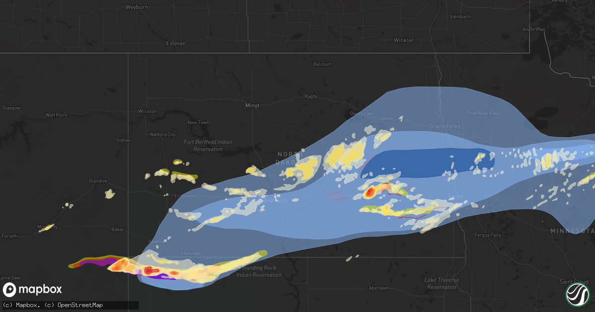
Hail Map in North Dakota on June 20, 2025
Get this storm
June 20 map
$229
one time, instant access
Download today. No call, no setup
Keep the $229
Bought the map and want the full workflow? Apply the entire $229 to a subscription within 7 days. None of it is wasted.
Every map, not just this one
This buys you this map. Subscription and you get every map we run, in the markets you choose from a few cities to whole states to nationwide. Plus real-time alerts the moment a storm fires.
Contact data
Name, contact info, occupancy, even credit band for addresses in the footprint. You go from where it hit to who to call.
Become the source they trust
Unlimited branding weather history reports on demand. You already have the documented answer ready for the property owner, and you are the one who showed up with it.
Property data and RoofTrace estimates
Pull up any address you have got, its value and the exact code rules for that jurisdiction, straight from One Click Code. Then RoofTrace estimates the squares, pitch, and roof value, priced the way you price.
Storm reports in North Dakota
North Dakota
| Date | Description |
|---|---|
| 06/20/20256:55 PM CDT | A local report indicates 1.00 inch wind near 7 E Fairfield |
| 06/20/20252:13 AM CDT | Estimated high winds for two hours. Signs bent... Railroad arms moved... Grain bin lifted and flipped. Report relayed via social media. |
| 06/20/20251:04 AM CDT | Ndawn station 2 ese of ypsilanti. |
| 06/20/202512:49 AM CDT | Wind gusts of 70 mph - 80 mph and power flashes were reported on social media. |
| 06/20/202512:34 AM CDT | Mesonet station awwn8 21 nnw jamestown |
| 06/20/202512:25 AM CDT | 5 se kensal |
| 06/20/202512:25 AM CDT | 4 n carrington |
| 06/20/202512:21 AM CDT | 10 meter measured gust ndawn 5w courtenay. |
| 06/20/202512:15 AM CDT | Awos station k46d carrington nd awos. |
| 06/20/202512:08 AM CDT | Public report of a thunderstorm wind gust as measured on a davis weather station. Measured 92 mph wind gust. |
| 06/20/202512:05 AM CDT | Mesonet station dvi12209 jamestown. |
| 06/19/202511:56 PM CDT | 10 meter measured gust ndawn 1s heaton. |
| 06/19/202511:50 PM CDT | Delayed report: a funnel cloud was reported in davenport with possible touchdown. |
| 06/19/202511:48 PM CDT | Ndawn station 10 w jamestown. 10 meter wind report. |
| 06/19/202511:45 PM CDT | 3 w eldridge |
| 06/19/202511:45 PM CDT | 2 e tappen |
| 06/19/202511:43 PM CDT | 10 meter measured gust ndawn 3e tappen. |
| 06/19/202511:31 PM CDT | A local report indicates 1.00 inch wind near Chaffee |
| 06/19/202511:29 PM CDT | 10 meter measured gust ndawn 5nw steele. |
| 06/19/202511:25 PM CDT | 4 wnw steele |
| 06/19/202511:25 PM CDT | 10 meter measured gust ndawn 2ne woodworth. |
| 06/19/202511:20 PM CDT | A tornado was reported southeast of enderlin. Location estimated via radar. |
| 06/19/202511:20 PM CDT | A tornado was |
| 06/19/202511:20 PM CDT | 2 w sykeston. |
| 06/19/202511:14 PM CDT | Tree branches 6 inches to 10 inches in diameter were reported down in valley city. |
| 06/19/202511:11 PM CDT | There were reports of home damage east/northeast of enderlin. Time estimated via radar. |
| 06/19/202511:11 PM CDT | Damage to multiple homes were reported 3 miles east of enderlin. |
| 06/19/202511:10 PM CDT | Nd dot sensor observation. |
| 06/19/202511:05 PM CDT | A local report indicates 80 MPH wind near La Moure |
| 06/19/202511:01 PM CDT | Ndawn station at ellendale. 10 meter wind gust report. |
| 06/19/202511:00 PM CDT | Denhoff |
| 06/19/202511:00 PM CDT | Mesonet station jtnn8 uscrn site near jamestown 38wsw. |
| 06/19/202510:58 PM CDT | Ndawn 10 meter observation. |
| 06/19/202510:58 PM CDT | 10 meter measured gust ndawn 3nnw robinson. |
| 06/19/202510:55 PM CDT | Photos relayed through social media from city of kensal of large trees uprooted. Time estimated from radar. |
| 06/19/202510:44 PM CDT | Asos station kjms jamestown airport. |
| 06/19/202510:40 PM CDT | Half of shop roof torn off and siding ripped off house. Radar estimated time. |
| 06/19/202510:34 PM CDT | 10 meter measured gust ndawn 1s jud. |
| 06/19/202510:34 PM CDT | Ndawn station near wirch. 10 meter wind gust report. |
| 06/19/202510:32 PM CDT | Ndawn 10 meter observation. |
| 06/19/202510:32 PM CDT | 10 meter measured gust ndawn 8n wing. |
| 06/19/202510:30 PM CDT | Stovepipe tornado reported n of fort ransom via public. |
| 06/19/202510:13 PM CDT | 10 meter measured wind gust ndawn 8n wing. |
| 06/19/202510:10 PM CDT | Social media report and pictures of a brief tornado north of verona and west of highway 1. |
| 06/19/202510:10 PM CDT | 6 wnw streeter |
| 06/19/202510:10 PM CDT | A local report indicates 88 MPH wind near 1 E Pettibone |
| 06/19/202510:05 PM CDT | 5 w wishek |
| 06/19/202510:04 PM CDT | 10 meter measured wind gust ndawn tappen 3e. |
| 06/19/202510:03 PM CDT | 10 meter measured wind gust ndawn streeter 6nw. |
| 06/19/202510:00 PM CDT | 10 meter measured wind gust robinson 3nnw. |
| 06/19/202510:00 PM CDT | 10 meter measured wind gust ndawn wishek 5w. |
| 06/19/202510:00 PM CDT | Facebook post from prairie meadows events shows damage at the venue. A variety of large trees are down... Including a very large tree split at the base. Time estimated |
| 06/19/20259:58 PM CDT | A tornado was reported 2 miles west of valley city. |
| 06/19/20259:58 PM CDT | A tornado was reported |
| 06/19/20259:45 PM CDT | Time estimated from radar. |
| 06/19/20259:40 PM CDT | Hazelton nddot site measured wind gust. |
| 06/19/20259:40 PM CDT | 10 meter measured gust ndawn 5nw linton. |
| 06/19/20259:36 PM CDT | Social media report of a few trees down and power outage for hazelton. Several branches also down. Time estimated based on radar. |
| 06/19/20259:35 PM CDT | Awos station k7l2 linton. |
| 06/19/20259:35 PM CDT | 10 meter measured wind gust ndawn 5nw linton. |
| 06/19/20259:33 PM CDT | 2.70 inches of rain too received via webmaster email. |
| 06/19/20259:30 PM CDT | Fort yates nddot station measured wind gust. |
| 06/19/20259:25 PM CDT | A funnel cloud was observed just south of sandborn. |
| 06/19/20259:25 PM CDT | Mesonet station ttkn8 tatanka prairie. |
| 06/19/20259:21 PM CDT | A tornado was reported just sw of the sandborn exit. (fg |
| 06/19/20259:21 PM CDT | A tornado was reported just sw of the sandborn exit. |
| 06/19/20259:20 PM CDT | Large hail during tornado warned storm. |
| 06/19/20259:20 PM CDT | 10 meter wind gust ndawn livona 5s. |
| 06/19/20259:20 PM CDT | Photos sent of damage near baldwin. 40x60 pole barn was mostly destroyed and debris was blown about 300 feet east-northeast from the building site. Most posts from the |
| 06/19/20259:19 PM CDT | Asos station kbis bismarck airport. |
| 06/19/20259:18 PM CDT | Mesonet station cw2059 6 n bismarck. |
| 06/19/20259:18 PM CDT | *** 1 inj *** social media report and photos of a large shop destroyed and blown across the road into neighbors property. A lot of debris in this yard. Garage door dama |
| 06/19/20259:17 PM CDT | 10 meter measured gust ndawn sanger 1s. |
| 06/19/20259:15 PM CDT | Awos station ky19 mandan. |
| 06/19/20259:15 PM CDT | Mesonet station ew9213 huff hills. |
| 06/19/20259:15 PM CDT | Numerous tree limbs down. |
| 06/19/20259:15 PM CDT | Large tree damage. |
| 06/19/20259:15 PM CDT | Tree limbs down in hillview area. |
| 06/19/20259:14 PM CDT | House damaged by tornado... Reported by a storm chaser. |
| 06/19/20259:10 PM CDT | Brief tornado touched down near stutsman and lamoure county line. Ndawn marion station webcam had visible funnel cloud around this time... And public submitted video of |
| 06/19/20259:10 PM CDT | Measured wind gust from bismarck i-94 bridge nddot site. |
| 06/19/20259:09 PM CDT | Social media report of downed trees near double ditch state recreation area. Time estimated based on radar. |
| 06/19/20259:07 PM CDT | Weather station. Also reported 1.31 inches of rain. |
| 06/19/20259:05 PM CDT | Large evergreen tree blown over near rosser ave and 26th street. |
| 06/19/20259:04 PM CDT | Center ndawn. |
| 06/19/20259:00 PM CDT | Numerous homes were reported damaged north of urbana and west of eckelson. Time estimated by radar. |
| 06/19/20259:00 PM CDT | Large... Partially rain-wrapped tornado reported 3 miles nw of eckelson. |
| 06/19/20259:00 PM CDT | Nddot sensor near new salem. |
| 06/19/20258:55 PM CDT | About a mile of power lines down along county road 84. Time estimated from radar. |
| 06/19/20258:50 PM CDT | A local report indicates a tornado near 2 ENE Spiritwood |
| 06/19/20258:47 PM CDT | 10 meter measured gust ndawn station new salem 6ne. |
| 06/19/20258:45 PM CDT | Public relayed photos of large tree snapped towards the base... And another tree that fell onto a house. Time estimated from radar. |
| 06/19/20258:45 PM CDT | Report from new salem fire department of multiple power lines down. Time estimated from radar. |
| 06/19/20258:40 PM CDT | Initial touchdown. |
| 06/19/20258:40 PM CDT | Photo of tornado from public matches up with reports of sightings from new salem area... And corroborated with radar data. No damage reported. |
| 06/19/20258:40 PM CDT | Photos of downed trees on highway 10 relayed through social media. Time estimated from radar. |
| 06/19/20258:40 PM CDT | 10 meter measured wind gust ndawn carson 9ene. |
| 06/19/20258:40 PM CDT | Photo relayed through social media of multiple trees broken. Time estimated from radar. |
| 06/19/20258:30 PM CDT | Mesonet station fw6805 lake tschida. |
| 06/19/20258:30 PM CDT | Social media report of shingles and siding off. |
| 06/19/20258:28 PM CDT | Downed cottonwood. Relayed via social media with a radar estimated time. |
| 06/19/20258:25 PM CDT | Public phone cal |
| 06/19/20258:25 PM CDT | Damage relayed from public through social media on north side of lake tschida. Damage includes camper tipped on its side... Pontoon completely flipped... Downed trees.. |
| 06/19/20258:25 PM CDT | 10 meter measured wind gust ndawn pretty rock 2e. |
| 06/19/20258:25 PM CDT | Public phone call. Picture also sent vis email. |
| 06/19/20258:17 PM CDT | 10 meter wind gust ndawn elgin 10nw. |
| 06/19/20258:11 PM CDT | Mesonet station tt584 12 e mott. |
| 06/19/20258:10 PM CDT | Nddot sensor near gladstone. |
| 06/19/20258:07 PM CDT | Report from mping: tea cup |
| 06/19/20258:07 PM CDT | Report from mping: tea cup (3.00 in |
| 06/19/20258:05 PM CDT | 10m wind gust mott 1n ndawn station. |
| 06/19/20258:05 PM CDT | Ongoing at time of report. |
| 06/19/20258:00 PM CDT | Hail still ongoing. Damage to car windshield. |
| 06/19/20257:59 PM CDT | Report from mping: hen egg |
| 06/19/20257:57 PM CDT | Asos station khei hettinger airport. |
| 06/19/20257:55 PM CDT | Weather station. |
| 06/19/20257:53 PM CDT | Asos station khei hettinger airport. |
| 06/19/20257:51 PM CDT | Report from mping: quarter |
| 06/19/20257:50 PM CDT | A local report indicates 1.50 inch wind near Jamestown |
| 06/19/20257:42 PM CDT | Asos station kdik dickinson airport. |
| 06/19/20257:30 PM CDT | A local report indicates 60 MPH wind near 9 SSW New England |
| 06/19/20257:15 PM CDT | Awos station kbww bowman airport. |
All States Impacted by Hail Map on June 20, 2025
Cities Impacted by Hail Map on June 20, 2025
- Leland, IA
- Forest City, IA
- Fertile, IA
- Garner, IA
- Ventura, IA
- Hanlontown, IA
- Clear Lake, IA
- Mason City, IA
- Rockwell, IA
- Bristow, IA
- Aredale, IA
- New Virginia, IA
- Marble Rock, IA
- Greene, IA
- Stout, IA
- Reinbeck, IA
- Dike, IA
- New Hartford, IA
- Grundy Center, IA
- Parkersburg, IA
- Holland, IA
- Cedar Falls, IA
- Aplington, IA
- Wellsburg, IA
- Ackley, IA
- Steamboat Rock, IA
- Traer, IA
- Dysart, IA
- Waterloo, IA
- Hudson, IA
- Buckingham, IA
- Morrison, IA
- La Porte City, IA
- Beaman, IA
- Gladbrook, IA
- Liscomb, IA
- Lincoln, IA
- Eldora, IA
- Conrad, IA
- Union, IA
- Whitten, IA
- Marshalltown, IA
- Clutier, IA
- Garwin, IA
- Toledo, IA
- Albion, IA
- Chelsea, IA
- Garrison, IA
- Tama, IA
- Keystone, IA
- Vining, IA
- Montour, IA
- Elberon, IA
- Le Grand, IA
- Belle Plaine, IA
- Sully, IA
- Lynnville, IA
- Pella, IA
- Reasnor, IA
- Knoxville, IA
- Harvey, IA
- New Smyrna Beach, FL
- Osteen, FL
- Plant City, FL
- Zephyrhills, FL
- Wesley Chapel, FL
- Tampa, FL
- Bartow, FL
- Thonotosassa, FL
- Starkville, MS
- Seffner, FL
- Brandon, FL
- Dover, FL
- Brooksville, FL
- Valrico, FL
- Boulder, MT
- Floral City, FL
- Homosassa, FL
- Lecanto, FL
- Inverness, FL
- Winston, MT
- Townsend, MT
- Fort McCoy, FL
- Toston, MT
- Old Town, FL
- White Sulphur Springs, MT
- Miles City, MT
- Garita, NM
- Williston, FL
- Terry, MT
- Martinsdale, MT
- Morriston, FL
- Florahome, FL
- Dunnellon, FL
- Beverly Hills, FL
- Interlachen, FL
- Volborg, MT
- Powderville, MT
- Ismay, MT
- Ekalaka, MT
- Fallon, MT
- Ocala, FL
- Loxley, AL
- Two Dot, MT
- Hawthorne, FL
- Glendive, MT
- Baker, MT
- Fairfield, ND
- Campbell, AL
- Gainesville, FL
- Tupelo, MS
- Hammond, MT
- Wibaux, MT
- Buffalo, SD
- Camp Crook, SD
- Killdeer, ND
- Anthony, FL
- Manning, ND
- Sorrento, FL
- Rhame, ND
- Ludlow, SD
- Bowman, ND
- Reva, SD
- Ralph, SD
- South Heart, ND
- Amidon, ND
- Belfield, ND
- Dickinson, ND
- Coffeeville, MS
- Dunn Center, ND
- Scranton, ND
- Medora, ND
- Gladstone, ND
- Reeder, ND
- New England, ND
- Hettinger, ND
- Regent, ND
- Lodgepole, SD
- Richardton, ND
- Lefor, ND
- Taylor, ND
- Mott, ND
- Halliday, ND
- Prairie City, SD
- Jamestown, ND
- Hebron, ND
- Lemmon, SD
- Bison, SD
- Sheridan Lake, CO
- Meadow, SD
- Glen Ullin, ND
- Selfridge, ND
- New Leipzig, ND
- Keldron, SD
- Elgin, ND
- Carson, ND
- Beulah, ND
- New Salem, ND
- Almont, ND
- Morristown, SD
- Watauga, SD
- Mandan, ND
- Flasher, ND
- Center, ND
- Hazen, ND
- Spiritwood, ND
- Montpelier, ND
- Jud, ND
- Sanborn, ND
- Wimbledon, ND
- McIntosh, SD
- Stanton, ND
- Raleigh, ND
- Shields, ND
- Solen, ND
- McLaughlin, SD
- Rogers, ND
- Washburn, ND
- Ypsilanti, ND
- Marion, ND
- Saint Anthony, ND
- Fort Yates, ND
- Walker, SD
- Moffit, ND
- Menoken, ND
- Hazelton, ND
- Cannon Ball, ND
- Bismarck, ND
- Linton, ND
- Zap, ND
- Wilton, ND
- Baldwin, ND
- Sterling, ND
- Regan, ND
- Valley City, ND
- Litchville, ND
- Driscoll, ND
- Tuttle, ND
- Wing, ND
- Braddock, ND
- Goodrich, ND
- Strasburg, ND
- Steele, ND
- Kintyre, ND
- Hague, ND
- Wishek, ND
- Zeeland, ND
- Napoleon, ND
- Denhoff, ND
- Hurdsfield, ND
- Mcclusky, ND
- Kathryn, ND
- Dawson, ND
- Tappen, ND
- Lehr, ND
- Ashley, ND
- Robinson, ND
- Fort Ransom, ND
- Hillsboro, ND
- Oriska, ND
- Gackle, ND
- Streeter, ND
- Fredonia, ND
- Kulm, ND
- Bowdon, ND
- Chaseley, ND
- Pettibone, ND
- Medina, ND
- Woodworth, ND
- Sykeston, ND
- Halstad, MN
- Nome, ND
- Enderlin, ND
- Cleveland, ND
- Edgeley, ND
- Carrington, ND
- Pingree, ND
- Buchanan, ND
- Sheldon, ND
- Shelly, MN
- Cathay, ND
- Ada, MN
- Gary, MN
- Lamoure, ND
- Fullerton, ND
- Ellendale, ND
- Dickey, ND
- Oakes, ND
- Kensal, ND
- Berlin, ND
- Glenfield, ND
- Courtenay, ND
- Hannaford, ND
- Sutton, ND
- Binford, ND
- Cooperstown, ND
- Dazey, ND
- Fertile, MN
- Fingal, ND
- Tower City, ND
- Caledonia, ND
- Hunter, ND
- Grandin, ND
- New Rockford, ND
- Fessenden, ND
- Leonard, ND
- Verona, ND
- Mcleod, ND
- Wyndmere, ND
- Stirum, ND
- Lisbon, ND
- Milnor, ND
- Amenia, ND
- Mapleton, ND
- Absaraka, ND
- Finley, ND
- Clifford, ND
- Arthur, ND
- Luverne, ND
- Wheatland, ND
- Ayr, ND
- Barney, ND
- Davenport, ND
- Page, ND
- Casselton, ND
- Erie, ND
- Walcott, ND
- Hope, ND
- Kindred, ND
- Pillsbury, ND
- Galesburg, ND
- Buffalo, ND
- Blanchard, ND
- Portland, ND
- Mchenry, ND
- Grace City, ND
- Harvey, ND
- Oberon, ND
- Mercer, ND
- Sheyenne, ND
- Maddock, ND
- Martin, ND
- Tolna, ND
- Jessie, ND
- Sharon, ND
- Warwick, ND
- Aneta, ND
- Mcville, ND
- Pekin, ND
- Hatton, ND
- Saint Michael, ND
- Fort Totten, ND
- Crary, ND
- Devils Lake, ND
- Lakota, ND
- Northwood, ND
- Michigan, ND
- Petersburg, ND
- Long Lake, SD
- Walker, MN
- Longville, MN
- Hackensack, MN
- Gardner, ND
- Laporte, MN
- Argusville, ND
- Harwood, ND
- Niagara, ND
- Cummings, ND
- Buxton, ND
- Thompson, ND
- Arvilla, ND
- Larimore, ND
- Emerado, ND
- Reynolds, ND
- Mayville, ND
- Comstock, MN
- Horace, ND
- West Fargo, ND
- Wahpeton, ND
- Dilworth, MN
- Wolverton, MN
- Fargo, ND
- Glyndon, MN
- Barnesville, MN
- Abercrombie, ND
- Sabin, MN
- Hendrum, MN
- Georgetown, MN
- Colfax, ND
- Moorhead, MN
- Perley, MN
- Kent, MN
- Christine, ND
- Inkster, ND
- Dahlen, ND
- Brocket, ND
- Lankin, ND
- Fordville, ND
- Grand Forks, ND
- Oslo, MN
- Gilby, ND
- Forest River, ND
- Manvel, ND
- East Grand Forks, MN
- Grand Forks Afb, ND
- Mekinock, ND
- Minto, ND
- Breckenridge, MN
- Fosston, MN
- Winger, MN
- Cass Lake, MN
- Remer, MN
- Bagley, MN
- Lengby, MN
- Bemidji, MN
- Twin Valley, MN
- Solway, MN
- Grand Rapids, MN
- Federal Dam, MN
- Bejou, MN
- Deer River, MN
- Hill City, MN
- Jacobson, MN
- Hayward, WI
- Borup, MN
- Cohasset, MN
- Warba, MN
- Bovey, MN
- Pengilly, MN
- Swan River, MN
- Lawton, ND
- Park River, ND
- Pisek, ND
- Adams, ND
- Grafton, ND
- Argyle, MN
- Hoople, ND
- Drayton, ND
- Hibbing, MN
- Goodland, MN
- Meadowlands, MN
- Cotton, MN
- Mahnomen, MN
- Clearbrook, MN
- Waubun, MN
- Floodwood, MN
- Cable, WI
- Edinburg, ND
- Edmore, ND
- Fairdale, ND
- Forbes, MN
- Shevlin, MN
- Blackduck, MN
- Pennington, MN
- Taconite, MN
- Iron, MN
- Mooreton, ND
- Audubon, MN
- Erhard, MN
- Hitterdal, MN
- Nielsville, MN
- Hawley, MN
- Pelican Rapids, MN
- Detroit Lakes, MN
- Lake Park, MN
- Felton, MN
- Vergas, MN
- Rothsay, MN
- Frazee, MN
- Climax, MN
- Ulen, MN
- Dent, MN
- Perham, MN
- Nevis, MN
- Naytahwaush, MN
- Callaway, MN
- Ponsford, MN
- Akeley, MN
- Beltrami, MN
- Park Rapids, MN
- Menahga, MN
- Crookston, MN
- Ogema, MN
- Osage, MN
- White Earth, MN
- Rochert, MN
- Gonvick, MN
- Goodridge, MN
- Euclid, MN
- Viking, MN
- Alvarado, MN
- Trail, MN
- Saint Hilaire, MN
- Plummer, MN
- Red Lake Falls, MN
- Gully, MN
- Donaldson, MN
- Thief River Falls, MN
- Stephen, MN
- Warren, MN
- Fisher, MN
- Karlstad, MN
- Erskine, MN
- Mcintosh, MN
- Strandquist, MN
- Brooks, MN
- Kennedy, MN
- Oklee, MN
- Lake George, MN
- Mentor, MN
- Newfolden, MN
- Gatzke, MN
- Redlake, MN
- Strathcona, MN
- Grygla, MN
- Greenbush, MN
- Puposky, MN
- Leonard, MN
- Badger, MN
- Wannaska, MN
- Middle River, MN
- Mason, WI
- Marengo, WI
- High Bridge, WI
- Eveleth, MN
- Elizabeth, MN
- Fergus Falls, MN
- Underwood, MN
- Ottertail, MN
- New York Mills, MN
- Richville, MN
- Wadena, MN
- Pine River, MN
- Sebeka, MN
- Backus, MN
- Staples, MN
- Ponemah, MN
- Redby, MN
- Hines, MN
- Marcell, MN
- Park Falls, WI
- Ashland, WI
- Talmoon, MN
- Mountain Iron, MN
- Makinen, MN
- Gilbert, MN
- Brimson, MN
- Two Harbors, MN
- Butternut, WI
- Crosslake, MN
- Pequot Lakes, MN
- Tenstrike, MN
- Bena, MN
- Squaw Lake, MN
- Max, MN
- Spring Lake, MN
- Kelliher, MN
- Bigfork, MN
- Wirt, MN
- Mizpah, MN
- Northome, MN
- Aurora, MN
- Virginia, MN
- Worden, MT
- Custer, MT
- Manitowish Waters, WI
- Embarrass, MN
- Mercer, WI
- Nashwauk, MN
- Hoyt Lakes, MN
- Biwabik, MN
- Swatara, MN
- Big Falls, MN
- Effie, MN
- Marble, MN
- Coleraine, MN
- Chisholm, MN
- Boulder Junction, WI
- Calumet, MN
- Keewatin, MN
- Kinney, MN
- Duluth, MN
- Isabella, MN
- Cook, MN
- Buhl, MN
- Side Lake, MN
- Angora, MN
- Britt, MN
- Verndale, MN
- Emily, MN
- Fifty Lakes, MN
- Merrifield, MN
- Outing, MN
- Crosby, MN
- Palisade, MN
- Babbitt, MN
- Soudan, MN
- Silver Bay, MN
- Ely, MN
- Tower, MN
- Aitkin, MN
- Mcgregor, MN
- Land O'Lakes, WI
- Watersmeet, MI
- Conover, WI
- Phelps, WI
- Tamarack, MN
- Motley, MN
- Nisswa, MN
- Brainerd, MN
- Baxter, MN
- Ironton, MN
- Deerwood, MN
- Garrison, MN
- Wright, MN
- Kettle River, MN
- Cromwell, MN
- Cloquet, MN
- Saginaw, MN
- Alborn, MN
- Carlton, MN
- Sawyer, MN
- Brookston, MN
- Esko, MN
- Canyon, MN
- Finland, MN
- Iron River, MI
- Sturgeon Lake, MN
- Barnum, MN
- Lena, WI
- Oconto, WI
- Wrenshall, MN
- Superior, WI
- Schroeder, MN
- South Range, WI
- Peshtigo, WI
- Marinette, WI
- Crystal Falls, MI
- Ontonagon, MI
- Dunbar, WI
- Menominee, MI
- Channing, MI
- Egg Harbor, WI
- Chassell, MI
- Pelkie, MI
- Cornucopia, WI
- Fish Creek, WI
- Toivola, MI
- Baileys Harbor, WI
- Bayfield, WI
- Atlantic Mine, MI
- Clam Lake, WI
- Fowler, MI
- Houghton, MI
- Saint Johns, MI
- Little Lake, MI
- Barronett, WI
- Shell Lake, WI
- Elsie, MI
- Couderay, WI
- Pipestone, MN
- Ruthton, MN
- Skanee, MI
- Winter, WI
- Hurley, WI
- Sarona, WI
- Holland, MN
- Roundup, MT
- Lanse, MI
- Lake Linden, MI
- Rapid River, MI
- Springbrook, WI
- Birchwood, WI
- Ironwood, MI
- Nisula, MI
- Cameron, WI
- Rice Lake, WI
- Lac Du Flambeau, WI
- Woodruff, WI
- Brusett, MT
- Mosby, MT
- Winnett, MT
- Owosso, MI
- Mass City, MI
- Exeland, WI
- Ladysmith, WI
- Sand Springs, MT
- Bruce, WI
- Glen Arbor, MI
- Empire, MI
- Maple City, MI
- Lake Leelanau, MI
- Tony, WI
- Baraga, MI
- Weyerhaeuser, WI
- Honor, MI
- Cedar, MI
- Glen Flora, WI
- Traverse City, MI
- Deer Park, WI
- Suttons Bay, MI
- Lake Ann, MI
- Michigamme, MI
- Holcombe, WI
- Interlochen, MI
- Williamsburg, MI
- Kalkaska, MI
- Marenisco, MI
- Rapid City, MI
- Elk Rapids, MI
- Alden, MI
- South Boardman, MI
- Mancelona, MI
- Kewadin, MI
- Bellaire, MI


