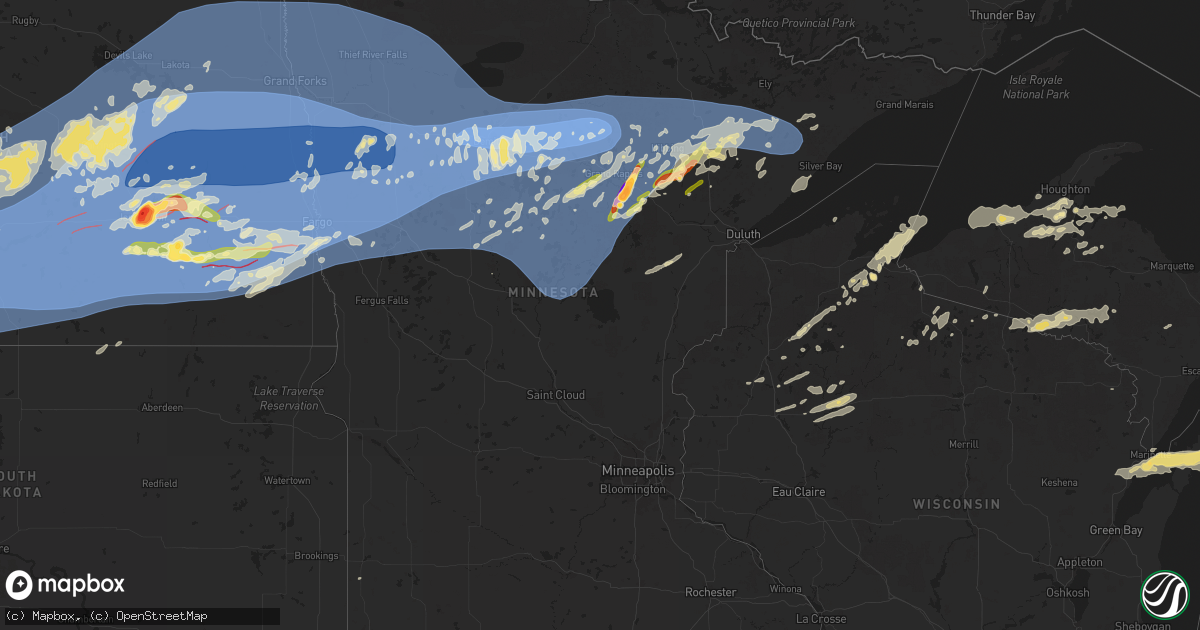
Hail Map in Minnesota on June 20, 2025
Get this storm
June 20 map
$229
one time, instant access
Download today. No call, no setup
Keep the $229
Bought the map and want the full workflow? Apply the entire $229 to a subscription within 7 days. None of it is wasted.
Every map, not just this one
This buys you this map. Subscription and you get every map we run, in the markets you choose from a few cities to whole states to nationwide. Plus real-time alerts the moment a storm fires.
Contact data
Name, contact info, occupancy, even credit band for addresses in the footprint. You go from where it hit to who to call.
Become the source they trust
Unlimited branding weather history reports on demand. You already have the documented answer ready for the property owner, and you are the one who showed up with it.
Property data and RoofTrace estimates
Pull up any address you have got, its value and the exact code rules for that jurisdiction, straight from One Click Code. Then RoofTrace estimates the squares, pitch, and roof value, priced the way you price.
Storm reports in Minnesota
Minnesota
| Date | Description |
|---|---|
| 06/20/20253:00 AM CDT | Tree fell on powerline... Briefly started a grass fire that was put out by rain. Time estimated by radar. |
| 06/20/20252:55 AM CDT | Photo sent in via social media showing a 30 foot section of a white pine tree that fell overnight. This pine tree caused damage to a duck enclosure with no duck injurie |
| 06/20/20252:55 AM CDT | Photo sent in via social media showing a 30 foot section of a white pine tree that fell overnight. This pine tree caused damage to a duck enclosure with no duck injurie |
| 06/20/20252:25 AM CDT | Photo sent in via social media of an aspen or birch tree that got blown over. This tree then fell onto a pole barn causing some structural damage. Time estimated from r |
| 06/20/20252:11 AM CDT | A local report indicates 61 MPH wind near 5 NE Brainerd |
| 06/20/20252:11 AM CDT | Mature 36 inch diameter poplar tree uprooted. This tree appears to have caused damage to an outbuilding after falling. |
| 06/20/20252:10 AM CDT | Time estimated from radar. |
| 06/20/20252:03 AM CDT | Trees stripped of leaves... Grill blown around yard. Several 4 inches branches down. |
| 06/20/20252:01 AM CDT | Corrects previous non-tstm wnd gst report from 1 w cass lake. Mesonet station casm5 cass lake dnr raws. |
| 06/20/20252:00 AM CDT | Widespread tree damage with limbs around 3 inches in diameter were reported. Time estimated via radar. |
| 06/20/20251:55 AM CDT | Delayed report from cross lake of a dozen trees on roadways and three trees on powerlines in the community of cross lake. |
| 06/20/20251:50 AM CDT | Photo sent in via social media of a power pole snapped and several trees blown over on top of power lines. Time estimated from radar. |
| 06/20/20251:40 AM CDT | Large tree partially blocking road... Tree partially on guide wires. Time estimated from radar. |
| 06/20/20251:30 AM CDT | Photos sent in via social media show tree damage including one tree that fell on top of a residence. |
| 06/20/20251:28 AM CDT | Spotter reports that numerous branches are down on their property. An entire tree was also blown over. Spotter reports that the tree that fell over was weaker and ready |
| 06/20/20251:15 AM CDT | Tree fell on powerlines and is partially on house roof. Time estimated from radar. |
| 06/20/20251:15 AM CDT | There were reports of power lines down and tree limbs up to 3 inches down. |
| 06/20/20251:10 AM CDT | One large tree down an many branches snapped off. Time estimated from radar. |
| 06/20/20251:10 AM CDT | Photos of numerous trees snapped and blown over. One picture also shows an uprooted tree. Time estimated from radar. |
| 06/20/202512:57 AM CDT | Tree down on camper. |
| 06/20/202512:50 AM CDT | There were reports of multiple branches down... Power flashes... And home damage. Winds were estimated at 80 mph. |
| 06/20/202512:26 AM CDT | Report from mping: quarter |
| 06/20/202512:26 AM CDT | A local report indicates 1.00 inch wind near 3 NNE Toivola |
| 06/20/202512:10 AM CDT | A local report indicates 60 MPH wind near 3 W Deer River |
| 06/20/202512:06 AM CDT | A local report indicates 1.00 inch wind near 4 WSW Tobique |
| 06/20/202512:00 AM CDT | A local report indicates 1.00 inch wind near 3 SW Cohasset |
| 06/19/202511:48 PM CDT | Corrects previous hail report from 4 wsw warba. Time estimated from radar. |
| 06/19/202511:46 PM CDT | A local report indicates 3.00 inch wind near 6 SSW Blackberry |
| 06/19/202511:30 PM CDT | Photo sent in via social media showing 2 inch diameter hail. Reporter states that it fell at approximately 1130pm. |
All States Impacted by Hail Map on June 20, 2025
Cities Impacted by Hail Map on June 20, 2025
- Leland, IA
- Forest City, IA
- Fertile, IA
- Garner, IA
- Ventura, IA
- Hanlontown, IA
- Clear Lake, IA
- Mason City, IA
- Rockwell, IA
- Bristow, IA
- Aredale, IA
- New Virginia, IA
- Marble Rock, IA
- Greene, IA
- Stout, IA
- Reinbeck, IA
- Dike, IA
- New Hartford, IA
- Grundy Center, IA
- Parkersburg, IA
- Holland, IA
- Cedar Falls, IA
- Aplington, IA
- Wellsburg, IA
- Ackley, IA
- Steamboat Rock, IA
- Traer, IA
- Dysart, IA
- Waterloo, IA
- Hudson, IA
- Buckingham, IA
- Morrison, IA
- La Porte City, IA
- Beaman, IA
- Gladbrook, IA
- Liscomb, IA
- Lincoln, IA
- Eldora, IA
- Conrad, IA
- Union, IA
- Whitten, IA
- Marshalltown, IA
- Clutier, IA
- Garwin, IA
- Toledo, IA
- Albion, IA
- Chelsea, IA
- Garrison, IA
- Tama, IA
- Keystone, IA
- Vining, IA
- Montour, IA
- Elberon, IA
- Le Grand, IA
- Belle Plaine, IA
- Sully, IA
- Lynnville, IA
- Pella, IA
- Reasnor, IA
- Knoxville, IA
- Harvey, IA
- New Smyrna Beach, FL
- Osteen, FL
- Plant City, FL
- Zephyrhills, FL
- Wesley Chapel, FL
- Tampa, FL
- Bartow, FL
- Thonotosassa, FL
- Starkville, MS
- Seffner, FL
- Brandon, FL
- Dover, FL
- Brooksville, FL
- Valrico, FL
- Boulder, MT
- Floral City, FL
- Homosassa, FL
- Lecanto, FL
- Inverness, FL
- Winston, MT
- Townsend, MT
- Fort McCoy, FL
- Toston, MT
- Old Town, FL
- White Sulphur Springs, MT
- Miles City, MT
- Garita, NM
- Williston, FL
- Terry, MT
- Martinsdale, MT
- Morriston, FL
- Florahome, FL
- Dunnellon, FL
- Beverly Hills, FL
- Interlachen, FL
- Volborg, MT
- Powderville, MT
- Ismay, MT
- Ekalaka, MT
- Fallon, MT
- Ocala, FL
- Loxley, AL
- Two Dot, MT
- Hawthorne, FL
- Glendive, MT
- Baker, MT
- Fairfield, ND
- Campbell, AL
- Gainesville, FL
- Tupelo, MS
- Hammond, MT
- Wibaux, MT
- Buffalo, SD
- Camp Crook, SD
- Killdeer, ND
- Anthony, FL
- Manning, ND
- Sorrento, FL
- Rhame, ND
- Ludlow, SD
- Bowman, ND
- Reva, SD
- Ralph, SD
- South Heart, ND
- Amidon, ND
- Belfield, ND
- Dickinson, ND
- Coffeeville, MS
- Dunn Center, ND
- Scranton, ND
- Medora, ND
- Gladstone, ND
- Reeder, ND
- New England, ND
- Hettinger, ND
- Regent, ND
- Lodgepole, SD
- Richardton, ND
- Lefor, ND
- Taylor, ND
- Mott, ND
- Halliday, ND
- Prairie City, SD
- Jamestown, ND
- Hebron, ND
- Lemmon, SD
- Bison, SD
- Sheridan Lake, CO
- Meadow, SD
- Glen Ullin, ND
- Selfridge, ND
- New Leipzig, ND
- Keldron, SD
- Elgin, ND
- Carson, ND
- Beulah, ND
- New Salem, ND
- Almont, ND
- Morristown, SD
- Watauga, SD
- Mandan, ND
- Flasher, ND
- Center, ND
- Hazen, ND
- Spiritwood, ND
- Montpelier, ND
- Jud, ND
- Sanborn, ND
- Wimbledon, ND
- McIntosh, SD
- Stanton, ND
- Raleigh, ND
- Shields, ND
- Solen, ND
- McLaughlin, SD
- Rogers, ND
- Washburn, ND
- Ypsilanti, ND
- Marion, ND
- Saint Anthony, ND
- Fort Yates, ND
- Walker, SD
- Moffit, ND
- Menoken, ND
- Hazelton, ND
- Cannon Ball, ND
- Bismarck, ND
- Linton, ND
- Zap, ND
- Wilton, ND
- Baldwin, ND
- Sterling, ND
- Regan, ND
- Valley City, ND
- Litchville, ND
- Driscoll, ND
- Tuttle, ND
- Wing, ND
- Braddock, ND
- Goodrich, ND
- Strasburg, ND
- Steele, ND
- Kintyre, ND
- Hague, ND
- Wishek, ND
- Zeeland, ND
- Napoleon, ND
- Denhoff, ND
- Hurdsfield, ND
- Mcclusky, ND
- Kathryn, ND
- Dawson, ND
- Tappen, ND
- Lehr, ND
- Ashley, ND
- Robinson, ND
- Fort Ransom, ND
- Hillsboro, ND
- Oriska, ND
- Gackle, ND
- Streeter, ND
- Fredonia, ND
- Kulm, ND
- Bowdon, ND
- Chaseley, ND
- Pettibone, ND
- Medina, ND
- Woodworth, ND
- Sykeston, ND
- Halstad, MN
- Nome, ND
- Enderlin, ND
- Cleveland, ND
- Edgeley, ND
- Carrington, ND
- Pingree, ND
- Buchanan, ND
- Sheldon, ND
- Shelly, MN
- Cathay, ND
- Ada, MN
- Gary, MN
- Lamoure, ND
- Fullerton, ND
- Ellendale, ND
- Dickey, ND
- Oakes, ND
- Kensal, ND
- Berlin, ND
- Glenfield, ND
- Courtenay, ND
- Hannaford, ND
- Sutton, ND
- Binford, ND
- Cooperstown, ND
- Dazey, ND
- Fertile, MN
- Fingal, ND
- Tower City, ND
- Caledonia, ND
- Hunter, ND
- Grandin, ND
- New Rockford, ND
- Fessenden, ND
- Leonard, ND
- Verona, ND
- Mcleod, ND
- Wyndmere, ND
- Stirum, ND
- Lisbon, ND
- Milnor, ND
- Amenia, ND
- Mapleton, ND
- Absaraka, ND
- Finley, ND
- Clifford, ND
- Arthur, ND
- Luverne, ND
- Wheatland, ND
- Ayr, ND
- Barney, ND
- Davenport, ND
- Page, ND
- Casselton, ND
- Erie, ND
- Walcott, ND
- Hope, ND
- Kindred, ND
- Pillsbury, ND
- Galesburg, ND
- Buffalo, ND
- Blanchard, ND
- Portland, ND
- Mchenry, ND
- Grace City, ND
- Harvey, ND
- Oberon, ND
- Mercer, ND
- Sheyenne, ND
- Maddock, ND
- Martin, ND
- Tolna, ND
- Jessie, ND
- Sharon, ND
- Warwick, ND
- Aneta, ND
- Mcville, ND
- Pekin, ND
- Hatton, ND
- Saint Michael, ND
- Fort Totten, ND
- Crary, ND
- Devils Lake, ND
- Lakota, ND
- Northwood, ND
- Michigan, ND
- Petersburg, ND
- Long Lake, SD
- Walker, MN
- Longville, MN
- Hackensack, MN
- Gardner, ND
- Laporte, MN
- Argusville, ND
- Harwood, ND
- Niagara, ND
- Cummings, ND
- Buxton, ND
- Thompson, ND
- Arvilla, ND
- Larimore, ND
- Emerado, ND
- Reynolds, ND
- Mayville, ND
- Comstock, MN
- Horace, ND
- West Fargo, ND
- Wahpeton, ND
- Dilworth, MN
- Wolverton, MN
- Fargo, ND
- Glyndon, MN
- Barnesville, MN
- Abercrombie, ND
- Sabin, MN
- Hendrum, MN
- Georgetown, MN
- Colfax, ND
- Moorhead, MN
- Perley, MN
- Kent, MN
- Christine, ND
- Inkster, ND
- Dahlen, ND
- Brocket, ND
- Lankin, ND
- Fordville, ND
- Grand Forks, ND
- Oslo, MN
- Gilby, ND
- Forest River, ND
- Manvel, ND
- East Grand Forks, MN
- Grand Forks Afb, ND
- Mekinock, ND
- Minto, ND
- Breckenridge, MN
- Fosston, MN
- Winger, MN
- Cass Lake, MN
- Remer, MN
- Bagley, MN
- Lengby, MN
- Bemidji, MN
- Twin Valley, MN
- Solway, MN
- Grand Rapids, MN
- Federal Dam, MN
- Bejou, MN
- Deer River, MN
- Hill City, MN
- Jacobson, MN
- Hayward, WI
- Borup, MN
- Cohasset, MN
- Warba, MN
- Bovey, MN
- Pengilly, MN
- Swan River, MN
- Lawton, ND
- Park River, ND
- Pisek, ND
- Adams, ND
- Grafton, ND
- Argyle, MN
- Hoople, ND
- Drayton, ND
- Hibbing, MN
- Goodland, MN
- Meadowlands, MN
- Cotton, MN
- Mahnomen, MN
- Clearbrook, MN
- Waubun, MN
- Floodwood, MN
- Cable, WI
- Edinburg, ND
- Edmore, ND
- Fairdale, ND
- Forbes, MN
- Shevlin, MN
- Blackduck, MN
- Pennington, MN
- Taconite, MN
- Iron, MN
- Mooreton, ND
- Audubon, MN
- Erhard, MN
- Hitterdal, MN
- Nielsville, MN
- Hawley, MN
- Pelican Rapids, MN
- Detroit Lakes, MN
- Lake Park, MN
- Felton, MN
- Vergas, MN
- Rothsay, MN
- Frazee, MN
- Climax, MN
- Ulen, MN
- Dent, MN
- Perham, MN
- Nevis, MN
- Naytahwaush, MN
- Callaway, MN
- Ponsford, MN
- Akeley, MN
- Beltrami, MN
- Park Rapids, MN
- Menahga, MN
- Crookston, MN
- Ogema, MN
- Osage, MN
- White Earth, MN
- Rochert, MN
- Gonvick, MN
- Goodridge, MN
- Euclid, MN
- Viking, MN
- Alvarado, MN
- Trail, MN
- Saint Hilaire, MN
- Plummer, MN
- Red Lake Falls, MN
- Gully, MN
- Donaldson, MN
- Thief River Falls, MN
- Stephen, MN
- Warren, MN
- Fisher, MN
- Karlstad, MN
- Erskine, MN
- Mcintosh, MN
- Strandquist, MN
- Brooks, MN
- Kennedy, MN
- Oklee, MN
- Lake George, MN
- Mentor, MN
- Newfolden, MN
- Gatzke, MN
- Redlake, MN
- Strathcona, MN
- Grygla, MN
- Greenbush, MN
- Puposky, MN
- Leonard, MN
- Badger, MN
- Wannaska, MN
- Middle River, MN
- Mason, WI
- Marengo, WI
- High Bridge, WI
- Eveleth, MN
- Elizabeth, MN
- Fergus Falls, MN
- Underwood, MN
- Ottertail, MN
- New York Mills, MN
- Richville, MN
- Wadena, MN
- Pine River, MN
- Sebeka, MN
- Backus, MN
- Staples, MN
- Ponemah, MN
- Redby, MN
- Hines, MN
- Marcell, MN
- Park Falls, WI
- Ashland, WI
- Talmoon, MN
- Mountain Iron, MN
- Makinen, MN
- Gilbert, MN
- Brimson, MN
- Two Harbors, MN
- Butternut, WI
- Crosslake, MN
- Pequot Lakes, MN
- Tenstrike, MN
- Bena, MN
- Squaw Lake, MN
- Max, MN
- Spring Lake, MN
- Kelliher, MN
- Bigfork, MN
- Wirt, MN
- Mizpah, MN
- Northome, MN
- Aurora, MN
- Virginia, MN
- Worden, MT
- Custer, MT
- Manitowish Waters, WI
- Embarrass, MN
- Mercer, WI
- Nashwauk, MN
- Hoyt Lakes, MN
- Biwabik, MN
- Swatara, MN
- Big Falls, MN
- Effie, MN
- Marble, MN
- Coleraine, MN
- Chisholm, MN
- Boulder Junction, WI
- Calumet, MN
- Keewatin, MN
- Kinney, MN
- Duluth, MN
- Isabella, MN
- Cook, MN
- Buhl, MN
- Side Lake, MN
- Angora, MN
- Britt, MN
- Verndale, MN
- Emily, MN
- Fifty Lakes, MN
- Merrifield, MN
- Outing, MN
- Crosby, MN
- Palisade, MN
- Babbitt, MN
- Soudan, MN
- Silver Bay, MN
- Ely, MN
- Tower, MN
- Aitkin, MN
- Mcgregor, MN
- Land O'Lakes, WI
- Watersmeet, MI
- Conover, WI
- Phelps, WI
- Tamarack, MN
- Motley, MN
- Nisswa, MN
- Brainerd, MN
- Baxter, MN
- Ironton, MN
- Deerwood, MN
- Garrison, MN
- Wright, MN
- Kettle River, MN
- Cromwell, MN
- Cloquet, MN
- Saginaw, MN
- Alborn, MN
- Carlton, MN
- Sawyer, MN
- Brookston, MN
- Esko, MN
- Canyon, MN
- Finland, MN
- Iron River, MI
- Sturgeon Lake, MN
- Barnum, MN
- Lena, WI
- Oconto, WI
- Wrenshall, MN
- Superior, WI
- Schroeder, MN
- South Range, WI
- Peshtigo, WI
- Marinette, WI
- Crystal Falls, MI
- Ontonagon, MI
- Dunbar, WI
- Menominee, MI
- Channing, MI
- Egg Harbor, WI
- Chassell, MI
- Pelkie, MI
- Cornucopia, WI
- Fish Creek, WI
- Toivola, MI
- Baileys Harbor, WI
- Bayfield, WI
- Atlantic Mine, MI
- Clam Lake, WI
- Fowler, MI
- Houghton, MI
- Saint Johns, MI
- Little Lake, MI
- Barronett, WI
- Shell Lake, WI
- Elsie, MI
- Couderay, WI
- Pipestone, MN
- Ruthton, MN
- Skanee, MI
- Winter, WI
- Hurley, WI
- Sarona, WI
- Holland, MN
- Roundup, MT
- Lanse, MI
- Lake Linden, MI
- Rapid River, MI
- Springbrook, WI
- Birchwood, WI
- Ironwood, MI
- Nisula, MI
- Cameron, WI
- Rice Lake, WI
- Lac Du Flambeau, WI
- Woodruff, WI
- Brusett, MT
- Mosby, MT
- Winnett, MT
- Owosso, MI
- Mass City, MI
- Exeland, WI
- Ladysmith, WI
- Sand Springs, MT
- Bruce, WI
- Glen Arbor, MI
- Empire, MI
- Maple City, MI
- Lake Leelanau, MI
- Tony, WI
- Baraga, MI
- Weyerhaeuser, WI
- Honor, MI
- Cedar, MI
- Glen Flora, WI
- Traverse City, MI
- Deer Park, WI
- Suttons Bay, MI
- Lake Ann, MI
- Michigamme, MI
- Holcombe, WI
- Interlochen, MI
- Williamsburg, MI
- Kalkaska, MI
- Marenisco, MI
- Rapid City, MI
- Elk Rapids, MI
- Alden, MI
- South Boardman, MI
- Mancelona, MI
- Kewadin, MI
- Bellaire, MI


