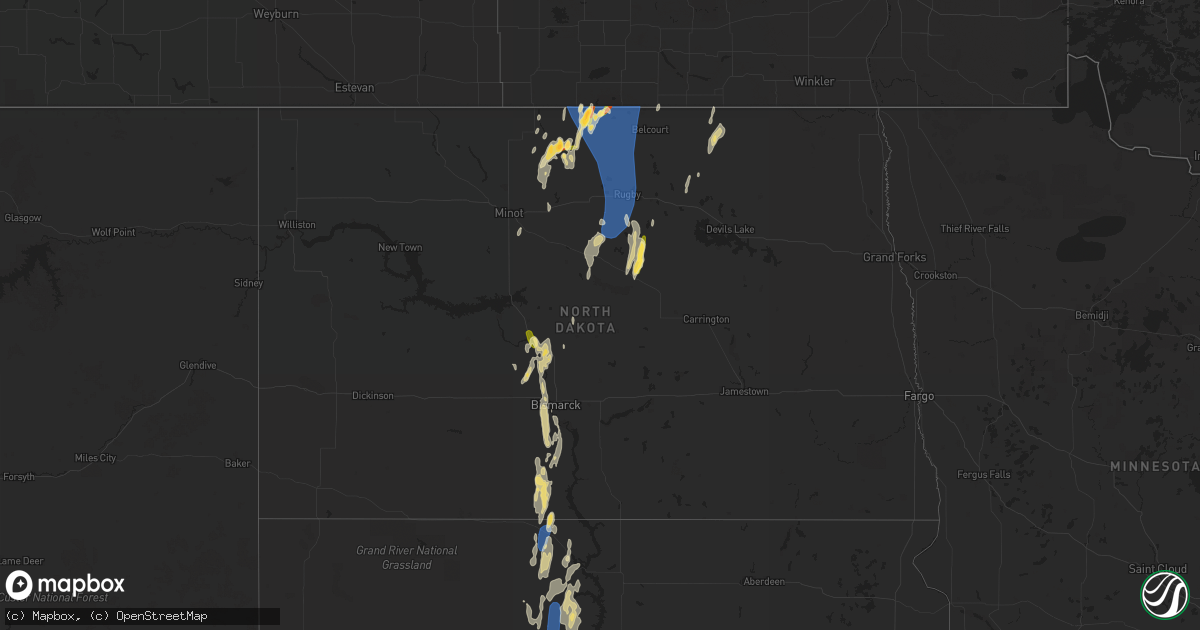
Hail Map in North Dakota on June 20, 2023
Get this storm
June 20 map
$229
one time, instant access
Download today. No call, no setup
Keep the $229
Bought the map and want the full workflow? Apply the entire $229 to a subscription within 7 days. None of it is wasted.
Every map, not just this one
This buys you this map. Subscription and you get every map we run, in the markets you choose from a few cities to whole states to nationwide. Plus real-time alerts the moment a storm fires.
Contact data
Name, contact info, occupancy, even credit band for addresses in the footprint. You go from where it hit to who to call.
Become the source they trust
Unlimited branding weather history reports on demand. You already have the documented answer ready for the property owner, and you are the one who showed up with it.
Property data and RoofTrace estimates
Pull up any address you have got, its value and the exact code rules for that jurisdiction, straight from One Click Code. Then RoofTrace estimates the squares, pitch, and roof value, priced the way you price.
Storm reports in North Dakota
North Dakota
| Date | Description |
|---|---|
| 06/20/20236:30 PM CDT | Relayed via broadcast media. |
| 06/20/20236:15 PM CDT | Dime to quarter size hail. |
| 06/20/20236:15 PM CDT | Mesonet station ew9213 huff hills. |
| 06/19/20239:19 PM CDT | Time estimated based on radar and nddot wind gust observation from near dunseith. Many large tree branches down. Several trees were uprooted. Some damage to roofs. Powe |
| 06/19/20239:19 PM CDT | Nd dot station us-281 near dunseith. |
| 06/19/20238:55 PM CDT | Very gust winds around 60 mph and hail stones around quarter size to half dollar size. |
| 06/19/20238:45 PM CDT | Mesonet station 327269 3 wsw rugby |
| 06/19/20238:36 PM CDT | Relayed via social media. |
| 06/19/20238:34 PM CDT | Davis private weather instrument observation. |
| 06/19/20238:30 PM CDT | Numerous trees damaged. Cottonwoods |
| 06/19/20238:23 PM CDT | Multiple downed tree branches reported on social media. |
| 06/19/20238:23 PM CDT | Highest wind lasted about 10 minutes. Extensive damage included: 5 empty anchored down hopper style grain bins blown over... Trailer rolled through the yard... Gazebo d |
| 06/19/20238:15 PM CDT | No wind damage. Hail lasted a few minutes. |
| 06/19/20237:58 PM CDT | Reported relayed via social media - radar estimated time. |
| 06/19/20237:55 PM CDT | Pea size then quarter size hail. Lasted about 10 minutes. 7:45 pm to 7:55 pm. |
| 06/19/20237:15 PM CDT | Tree approximately 10 inches in diameter split. Time estimated via radar. |
| 06/19/20237:10 PM CDT | Hail for about 20 mins. Started as pea size and increased to half dollar size. Approximately 6:50pm to 7:10pm estimated wind gusts to 55 mph. Heavy rain. |
| 06/19/20237:08 PM CDT | Relayed via social media. |
| 06/19/20237:03 PM CDT | Mesonet station 325479 4s mandan |
All States Impacted by Hail Map on June 20, 2023
Cities Impacted by Hail Map on June 20, 2023
- Long Beach, MS
- Pass Christian, MS
- Newellton, LA
- Kenansville, FL
- McHenry, MS
- Perkinston, MS
- Clayton, LA
- Sicily Island, LA
- Gilbert, LA
- Oviedo, FL
- Saint Bernard, LA
- Dodson, LA
- Gulfport, MS
- Alto, TX
- Rusk, TX
- Saucier, MS
- Kennard, TX
- Poplarville, MS
- Winnsboro, LA
- Wisner, LA
- Grayson, LA
- Kelly, LA
- Geneva, FL
- Tylertown, MS
- Franklinton, LA
- Meadville, MS
- McCall Creek, MS
- New Smyrna Beach, FL
- Smithdale, MS
- Edgewater, FL
- Grapeland, TX
- Osteen, FL
- Fort Necessity, LA
- Apple Springs, TX
- Groveton, TX
- Columbia, LA
- Frankston, TX
- Sandy Hook, MS
- Biloxi, MS
- Diberville, MS
- Harrisonburg, LA
- Enterprise, LA
- Ocala, FL
- Summerfield, FL
- Belleview, FL
- Belle Chasse, LA
- Braithwaite, LA
- Port Sulphur, LA
- Hahnville, LA
- Des Allemands, LA
- Thibodaux, LA
- Wilson, LA
- Ethel, LA
- Boyce, LA
- Otis, LA
- Slaughter, LA
- Saint James, LA
- Napoleonville, LA
- Port Allen, LA
- Elmer, LA
- Hineston, LA
- Sieper, LA
- Brusly, LA
- Zachary, LA
- Addis, LA
- Pride, LA
- Plaquemine, LA
- Baton Rouge, LA
- Sunshine, LA
- Ridgeview, SD
- Eagle Butte, SD
- McLaughlin, SD
- Labadieville, LA
- Glenmora, LA
- Timber Lake, SD
- Kiln, MS
- Casper, WY
- Jeffrey City, WY
- Slidell, LA
- Bradley, SC
- Greenwood, SC
- Pine Grove, LA
- Mount Hermon, LA
- Fort Lauderdale, FL
- Mountain Home, TX
- Leakey, TX
- Rocksprings, TX
- Donaldsonville, LA
- Darrow, LA
- Mayville, NY
- Sherman, NY
- Calvin, ND
- Egeland, ND
- Rocklake, ND
- Munich, ND
- Greensburg, LA
- Glenwood, GA
- Rockledge, GA
- Dublin, GA
- Vacherie, LA
- East Dublin, GA
- Jackson, LA
- Okeechobee, FL
- Lockport, LA
- Ama, LA
- Raceland, LA
- Murdo, SD
- Norwood, LA
- Clinton, LA
- Moore Haven, FL
- Gray Court, SC
- Lake Placid, FL
- Pearl River, LA
- Abita Springs, LA
- Union Church, MS
- Lafitte, LA
- Marrero, LA
- Barataria, LA
- Edgard, LA
- West Palm Beach, FL
- Convent, LA
- Louisville, GA
- Loxahatchee, FL
- Lorida, FL
- Bay Saint Louis, MS
- Waveland, MS
- Boynton Beach, FL
- Saint Francisville, LA
- Winter Springs, FL
- Picayune, MS
- Lake Wales, FL
- Bowling Green, KY
- Alvaton, KY
- Westwego, LA
- Luling, LA
- Boutte, LA
- Cut Off, LA
- Gheens, LA
- Paulina, LA
- Belle Rose, LA
- Paradis, LA
- Harvey, ND
- Pineville, LA
- Center Point, LA
- Marksville, LA
- Lecompte, LA
- Hessmer, LA
- Alexandria, LA
- Saint Gabriel, LA
- Esmond, ND
- Maddock, ND
- Port Barre, LA
- Lottie, LA
- Krotz Springs, LA
- Saint Martinville, LA
- Breaux Bridge, LA
- Natrona, WY
- Washburn, ND
- Center, ND
- Bottineau, ND
- Harrison, NE
- Dunseith, ND
- White Castle, LA
- Carville, LA
- Gillette, WY
- Rugby, ND
- Drake, ND
- Towner, ND
- Balta, ND
- Willow City, ND
- Rolette, ND
- Douglas, WY
- Kramer, ND
- Belcourt, ND
- Saint John, ND
- Souris, ND
- Upton, WY
- Newcastle, WY
- Rozet, WY
- Moorcroft, WY
- Osage, WY
- Woodworth, LA
- Kilgore, NE
- Fort Pierre, SD
- Arcadia, FL
- Venus, FL
- Punta Gorda, FL
- White River, SD
- Deville, LA
- Baldwin, ND
- Wilton, ND
- Saint Anthony, ND
- Solen, ND
- Mandan, ND
- Wakpala, SD
- Morgan City, LA
- Berwick, LA
- Patterson, LA
- Theriot, LA
- Glennville, GA
- Plaucheville, LA
- Simmesport, LA
- Draper, SD
- Baker, LA
- Greenwell Springs, LA
- Denham Springs, LA
- Selfridge, ND
- Fort Yates, ND
- Dundee, KY
- Fordsville, KY
- Horse Branch, KY
- Olaton, KY
- Dawson, GA
- Batchelor, LA
- Yuma, CO
- Hartford, KY
- Geismar, LA
- Saint Francis, SD
- Prairieville, LA
- Gonzales, LA
- Livingston, LA
- Maurepas, LA
- Franklin, LA
- New Iberia, LA
- Bunkie, LA
- Marsland, NE
- Lettsworth, LA
- Hayes Center, NE
- Fordoche, LA
- Walker, LA
- Wright, WY
- Cheneyville, LA
- Milledgeville, GA
- Grosse Tete, LA
- Maringouin, LA
- Sylvester, GA
- Selma, AL
- Cando, ND
- Trail City, SD
- Golden Meadow, LA
- Clewiston, FL
- Jeanerette, LA
- Baldwin, LA
- Mcclusky, ND
- Bush, LA
- New Orleans, LA
- Ray City, GA
- Valdosta, GA
- Erwinville, LA
- Lakeland, LA
- Amite, LA
- Holden, LA
- Pitkin, LA
- Hill City, SD
- Nashville, GA
- Lakeland, GA
- Moody Afb, GA
- Naylor, GA
- Cottonport, LA
- Barksdale, TX
- Youngsville, LA
- Abbeville, LA
- Erath, LA
- Mansura, LA
- Jarreau, LA
- Custer, SD
- Lafayette, LA
- Broussard, LA
- Reidsville, GA
- Camp Wood, TX
- Lake Park, GA
- Okaton, SD
- Forest Hill, LA
- Effie, LA
- Sorrento, LA
- New Roads, LA
- Morganza, LA
- Ventress, LA
- Coosada, AL
- Evergreen, LA
- Gibson, LA
- Independence, LA
- Butte, ND
- Little Eagle, SD
- Parmelee, SD
- Moreauville, LA
- Labelle, FL
- Pierre Part, LA
- Maywood, NE
- Vivian, SD
- Albany, LA
- Washington, LA
- Augusta, GA
- Hephzibah, GA
- French Settlement, LA
- Saint Amant, LA
- Delcambre, LA
- Norris, SD
- Boca Raton, FL
- Rosedale, LA
- Morrow, LA
- Montgomery, AL
- Edgefield, SC
- Pompano Beach, FL
- Catherine, AL
- Delray Beach, FL
- Statesboro, GA
- Oakdale, LA
- Leesville, LA
- Donner, LA
- Schriever, LA
- Oscar, LA
- Plattenville, LA
- Livonia, LA
- Ville Platte, LA
- Glendo, WY
- Jay Em, WY
- Lusk, WY
- Oberlin, LA
- Rosebud, SD
- Hot Springs, SD
- Buffalo Gap, SD
- Fairburn, SD
- Grant, LA
- Sugartown, LA
- Dry Creek, LA
- Westhope, ND
- Bismarck, ND
- Bantry, ND
- Granville, ND
- Sarles, ND
- Evergreen, AL
- Troy, AL
- Warwick, GA
- Ashburn, GA
- Newburg, ND
- Upham, ND
- Rolla, ND
- Deering, ND
- Manville, WY
- Hanston, KS
- Wetumpka, AL
- Glencross, SD
- Hayes, SD
- Saint Landry, LA
- Springfield, LA
- Melville, LA
- Palmetto, LA
- Keystone, SD
- Lance Creek, WY
- Shawnee, WY
- Anamoose, ND
- Cuthbert, GA
- Deridder, LA
- Wray, GA
- Jacksonville, GA
- Letohatchee, AL
- Hayneville, AL
- Abbeville, GA
- Minot, ND
- Sawyer, ND
- Edgemont, SD
- Sarasota, FL
- Hermosa, SD
- Fitzgerald, GA
- Oconto, NE
- Tallassee, AL
- Camden, AL
- Ness City, KS
- Tyler, AL
- Lena, LA
- Elizabeth, LA
- Colfax, LA
- Dry Prong, LA
- Opelousas, LA
- Rougon, LA
- Iuka, KS
- Pratt, KS
- Turon, KS
- Cunningham, KS
- Arlington, KS
- Kingman, KS
- Johnstown, NE
- Lexington, NE
- Hill City, KS
- Chase, KS
- Ellinwood, KS
- Long Pine, NE
- Ainsworth, NE
- Little River, KS
- Geneseo, KS
- Burdett, KS
- Loomis, NE
- Bertrand, NE
- Oxford, NE
- Miller, NE
- Amherst, NE
- Elwood, NE
- Larned, KS
- Lyons, KS
- Edison, NE
- Penokee, KS
- Hoisington, KS
- Claflin, KS
- Lorraine, KS
- Ellsworth, KS
- Bazine, KS
- Olmitz, KS
- Great Bend, KS
- Albert, KS
- Victoria, KS
- Russell, KS
- Walker, KS
- Gorham, KS
- Hays, KS
- Arapahoe, NE
- Glade, KS
- Stockton, KS
- Phillipsburg, KS
- Sylvan Grove, KS
- Mason City, NE
- Beverly, KS
- Lincoln, KS
- Rozel, KS
- Ravenna, NE
- Elm Creek, NE
- Holdrege, NE
- Smithfield, NE
- Roseland, NE
- Luray, KS
- Otis, KS
- Bison, KS
- Bradenton, FL
- Long Valley, SD
- Terra Ceia, FL
- Anna Maria, FL
- Palmetto, FL
- Bradenton Beach, FL
- Kinsley, KS
- Miami, FL
- Hialeah, FL
- Gibbon, NE
- Haviland, KS
- Belpre, KS
- Lewis, KS
- Windom, KS
- Holyrood, KS
- Greensburg, KS
- Garfield, KS


