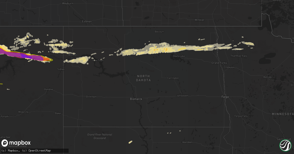
Hail Map in North Dakota on June 18, 2016
Get this storm
June 18 map
$229
one time, instant access
Download today. No call, no setup
Keep the $229
Bought the map and want the full workflow? Apply the entire $229 to a subscription within 7 days. None of it is wasted.
Every map, not just this one
This buys you this map. Subscription and you get every map we run, in the markets you choose from a few cities to whole states to nationwide. Plus real-time alerts the moment a storm fires.
Contact data
Name, contact info, occupancy, even credit band for addresses in the footprint. You go from where it hit to who to call.
Become the source they trust
Unlimited branding weather history reports on demand. You already have the documented answer ready for the property owner, and you are the one who showed up with it.
Property data and RoofTrace estimates
Pull up any address you have got, its value and the exact code rules for that jurisdiction, straight from One Click Code. Then RoofTrace estimates the squares, pitch, and roof value, priced the way you price.
Storm reports in North Dakota
North Dakota
| Date | Description |
|---|---|
| 06/18/20165:10 AM CDT | Very heavy rain and numerous nickle to half dollar sized hail. |
| 06/18/20164:49 AM CDT | 1.50 inches of rain and a lot of quarter size hails |
| 06/18/20164:40 AM CDT | Mostly pea sized hail with a few quarter sized hail |
| 06/18/20164:30 AM CDT | Mostly pea sized hail with a few quarter sized hail. Time estimated based on radar. |
| 06/18/20164:22 AM CDT | Report posted via social media. Time estimated based on radar. |
| 06/18/20164:15 AM CDT | Hail just smaller than golfball reported. |
| 06/18/20163:50 AM CDT | Quarter to ping poing ball sized hail fell for a couple minutes. Report and photo via social media. Time estimated based on radar. |
| 06/18/20162:55 AM CDT | Relayed by broadcast media. Time estimated from radar. |
| 06/18/20162:23 AM CDT | Quarter sized hail in south minot. |
| 06/18/201612:05 AM CDT | Crosby raws site. Time estimated from radar. |
All States Impacted by Hail Map on June 18, 2016
Cities Impacted by Hail Map on June 18, 2016
- Mangum, OK
- Gould, OK
- Blanco, OK
- Pittsburg, OK
- Mcalester, OK
- Hartshorne, OK
- Kiowa, OK
- Badger, MN
- Watford City, ND
- Wolf Point, MT
- Malta, MT
- Lankin, ND
- Havre, MT
- Peerless, MT
- Manvel, TX
- Houston, TX
- Pearland, TX
- Rosharon, TX
- Milton, ND
- Edinburg, ND
- Bienville, LA
- Saline, LA
- Vale, SD
- Newell, SD
- Pasadena, TX
- Galena Park, TX
- Turkey, TX
- Childress, TX
- Osage, OK
- Hominy, OK
- Prue, OK
- Larslan, MT
- Chinook, MT
- Lloyd, MT
- Vandalia, MT
- Glasgow, MT
- Hinsdale, MT
- Zahl, ND
- Williston, ND
- Winnie, TX
- Hays, MT
- Brockton, MT
- Saco, MT
- Grand Chenier, LA
- Plentywood, MT
- Woodville, MS
- Towner, ND
- Knox, ND
- Rugby, ND
- Lawton, ND
- Webster, ND
- Penn, ND
- Edmore, ND
- York, ND
- Churchs Ferry, ND
- Adams, ND
- Devils Lake, ND
- Leeds, ND
- Poplar, MT
- Woodworth, LA
- Alexandria, LA
- Allen, OK
- Dry Prong, LA
- Des Lacs, ND
- Burlington, ND
- Fort Peck, MT
- Matador, TX
- Big Sandy, MT
- Medicine Lake, MT
- Homestead, MT
- Newfolden, MN
- Grafton, ND
- New Town, ND
- Angola, LA
- Saint Francisville, LA
- Palm Bay, FL
- La Porte, TX
- Harlem, MT
- Dodson, MT
- Palermo, ND
- Stanley, ND
- Deer Park, TX
- Baytown, TX
- Channelview, TX
- Gatzke, MN
- Grygla, MN
- Middle River, MN
- Parshall, ND
- Park River, ND
- Pisek, ND
- Pauls Valley, OK
- Wynnewood, OK
- Antlers, OK
- Glenmora, LA
- Esmond, ND
- Starkweather, ND
- Granville, ND
- Wolford, ND
- Cando, ND
- Fordville, ND
- Bisbee, ND
- Karlsruhe, ND
- Savanna, OK
- Clayton, OK
- Aspermont, TX
- Sugar Land, TX
- Missouri City, TX
- Wharton, TX
- East Bernard, TX
- Clinton, OK
- Berthold, ND
- Moyers, OK
- Argyle, MN
- Stephen, MN
- Strandquist, MN
- Winfield, KS
- Tell, TX
- Okeechobee, FL
- Jenks, OK
- Nashua, MT
- Wetumka, OK
- Brenham, TX
- Bellville, TX
- Paris, TX
- Pattonville, TX
- Cordell, OK
- Gotebo, OK
- Dagmar, MT
- Grenora, ND
- Beaumont, TX
- Leola, SD
- Box Elder, MT
- Norwood, LA
- Centreville, MS
- Frazer, MT
- Depew, OK
- Port Sulphur, LA
- Eureka, SD
- Holdenville, OK
- Sasakwa, OK
- Cohagen, MT
- Lake Arthur, LA
- Lacassine, LA
- Grand Cane, LA
- Davis, OK
- Cameron, LA
- Willow City, ND
- Surrey, ND
- Minot, ND
- Norwich, ND
- Velva, ND
- Timber Lake, SD
- Rayville, LA
- Calvin, OK
- Granite, OK
- Clarendon, TX
- Castor, LA
- Culbertson, MT
- Froid, MT
- Bainville, MT
- Nisland, SD
- Vinson, OK
- Mims, FL
- Seabrook, TX
- Richmond, TX
- Stafford, TX
- Belle Fourche, SD
- Lake Placid, FL
- Hobart, OK
- Melbourne Beach, FL
- Brush Prairie, WA
- Dunnellon, FL
- Morriston, FL
- Alexander, ND
- Tulsa, OK
- Sand Springs, OK
- Pierson, FL
- Jamestown, LA
- Lettsworth, LA
- Arapaho, OK
- Weleetka, OK
- Pineland, TX
- Saint Cloud, FL
- Cartwright, ND
- Pelican, LA
- Dodson, LA
- Paducah, TX
- Scobey, MT
- Flaxville, MT
- Fort McCoy, FL
- Hollis, OK
- Golden Meadow, LA
- Princeton, LA
- Minden, LA
- Doyline, LA
- Brandon, FL
- Keene, ND
- Converse, LA
- Braithwaite, LA
- Timpson, TX
- Crystal, ND
- Heflin, LA
- Dubberly, LA
- Miami, FL
- Montgomery, LA
- Norman, OK
- Oklahoma City, OK
- Newcastle, OK
- Hanna, OK
- Dustin, OK
- Epping, ND
- Arnegard, ND
- Logansport, LA
- Wewoka, OK
- Quanah, TX
- Woodville, TX
- Needville, TX
- Rosenberg, TX
- Broaddus, TX
- Fort Pierce, FL
- Willow, OK
- Reserve, MT
- Centrahoma, OK
- Atwood, OK
- Coalgate, OK
- Port Arthur, TX
- Stratford, OK
- Spencer, OK
- Plain Dealing, LA
- Muldoon, TX
- Indianola, OK
- Stroud, OK
- Davenport, OK
- Chandler, OK
- Karlstad, MN
- Wilson, LA
- Clinton, LA
- Vero Beach, FL
- Sturgis, SD
- Delhi, LA
- Winnsboro, LA
- Daytona Beach, FL
- Port Orange, FL
- Richland, MT
- Center, TX
- Hampden, ND
- Mansfield, LA
- Palm Beach, FL
- Bronson, TX
- Old Town, FL
- San Augustine, TX
- Belle Chasse, LA
- Lafitte, LA
- Dickinson, TX
- Santa Fe, TX
- Alvin, TX
- Sebring, FL
- Deland, FL
- Hialeah, FL
- Sikes, LA
- Lambert, MT
- Fairview, MT
- Vida, MT
- Snyder, TX
- Lone Wolf, OK
- Sanford, FL
- Winter Park, FL
- Orlando, FL
- Friendswood, TX
- Drayton, ND
- Minto, ND
- Forest River, ND
- Fairdale, ND
- Corn, OK
- Sebastian, FL
- Melbourne, FL
- Malabar, FL
- Greenbush, MN
- Strathcona, MN
- Williston, FL
- Plaza, ND
- Lane, OK
- Anahuac, TX
- Pawnee, OK
- Joaquin, TX
- Mounds, OK
- Beggs, OK
- Kellyville, OK
- Sapulpa, OK
- Gary, TX
- Thief River Falls, MN
- Jonesboro, LA
- Okemah, OK
- Texas City, TX
- McLaughlin, SD
- Alamo, ND
- Canton, TX
- Talco, TX
- Gibsland, LA
- Lexington, OK
- Wanette, OK
- League City, TX
- Glen Flora, TX
- Sparks, OK
- Prague, OK
- Kemah, TX
- Monroe, LA
- Barataria, LA
- Byars, OK
- Mcpherson, KS
- Simsboro, LA
- Warren, MN
- Sibley, LA
- Interlachen, FL
- Quitman, LA
- Bristow, OK
- Lakeview, TX
- Trenton, FL
- Forest Hill, LA
- Memphis, TX
- Colfax, LA
- Jordan, MT


