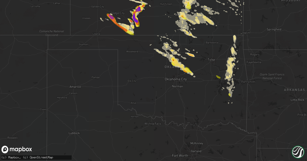
Hail Map in Oklahoma on June 17, 2017
Get this storm
June 17 map
$229
one time, instant access
Download today. No call, no setup
Keep the $229
Bought the map and want the full workflow? Apply the entire $229 to a subscription within 7 days. None of it is wasted.
Every map, not just this one
This buys you this map. Subscription and you get every map we run, in the markets you choose from a few cities to whole states to nationwide. Plus real-time alerts the moment a storm fires.
Contact data
Name, contact info, occupancy, even credit band for addresses in the footprint. You go from where it hit to who to call.
Become the source they trust
Unlimited branding weather history reports on demand. You already have the documented answer ready for the property owner, and you are the one who showed up with it.
Property data and RoofTrace estimates
Pull up any address you have got, its value and the exact code rules for that jurisdiction, straight from One Click Code. Then RoofTrace estimates the squares, pitch, and roof value, priced the way you price.
Storm reports in Oklahoma
Oklahoma
| Date | Description |
|---|---|
| 06/17/201711:20 AM CDT | Barn damaged/destroyed in panola. Tree damage all across latimer county. |
| 06/17/201711:00 AM CDT | A local report indicates 1.00 inch wind near PANOLA |
| 06/17/201710:50 AM CDT | A local report indicates 65 MPH wind near 1 W WILBURTON |
| 06/17/20179:55 AM CDT | A local report indicates 67 MPH wind near WEBBERS FALLS |
| 06/17/20179:47 AM CDT | Electric lines down on hwy 64 bridge near webbers falls. Time estimated by radar. |
| 06/17/20179:36 AM CDT | Power pole down on ray fine blvd in gore. Time estimated by radar. |
| 06/17/20179:30 AM CDT | Flag pole blown down in gore. Time estimated by radar. |
| 06/17/20179:07 AM CDT | Several large trees down east of fort gibson. Time estimated by radar. |
| 06/17/20179:01 AM CDT | Power lines across hwy 100 in webbers falls. Time estimated by radar. |
| 06/17/20178:50 AM CDT | Measured 1 mile east of tahlequah airport. Power out in parts of tahlequah. |
| 06/17/20178:10 AM CDT | Several trees down in kansas. |
| 06/17/20177:36 AM CDT | Tree down in afton. Time estimated by radar. |
| 06/17/20176:43 AM CDT | Between morrison and pawnee. Time estimated by radar. |
| 06/17/20176:15 AM CDT | Golf ball size hail in lela. |
| 06/17/20173:50 AM CDT | A local report indicates 70 MPH wind near 4 SSE MARSHALL |
| 06/17/20173:45 AM CDT | 65 mph wind gust at the marshall mesonet. |
| 06/16/201710:35 PM CDT | A local report indicates 59 MPH wind near 16 NNE FREEDOM |
All States Impacted by Hail Map on June 17, 2017
Cities Impacted by Hail Map on June 17, 2017
- Wellston, OK
- Minneola, KS
- Warner, OK
- Elk Falls, KS
- New Boston, IL
- Rose, OK
- Deland, FL
- De Leon Springs, FL
- Locust Grove, OK
- Peggs, OK
- Russellville, MO
- Eugene, MO
- Ashland, KS
- Timewell, IL
- Mount Sterling, IL
- Toronto, KS
- Neal, KS
- Eureka, KS
- Virgil, KS
- Gorham, KS
- Hays, KS
- Victoria, KS
- Cimarron, KS
- Ensign, KS
- Montezuma, KS
- Kearney, MO
- Polo, MO
- Lathrop, MO
- Holt, MO
- Lawson, MO
- Orrick, MO
- Excelsior Springs, MO
- Henry, IL
- Topeka, KS
- Marshall, OK
- Crescent, OK
- Mulhall, OK
- Orlando, OK
- Fall River, KS
- Fredonia, KS
- Hamilton, KS
- Protection, KS
- Coldwater, KS
- Larned, KS
- Muskogee, OK
- Derby, KS
- Rose Hill, KS
- Afton, OK
- Glyndon, MN
- Hawley, MN
- Lake Park, MN
- Kahoka, MO
- Saint Patrick, MO
- Rossville, KS
- Silver Lake, KS
- Hoyt, KS
- Greensburg, KS
- Baldwin City, KS
- Haviland, KS
- Mullinville, KS
- Fowler, KS
- Cary, IL
- Rozel, KS
- Bluejacket, OK
- Welch, OK
- Miami, OK
- Latham, KS
- Alma, KS
- Dwight, KS
- Junction City, KS
- Chillicothe, MO
- Bethel, MO
- Shelbyville, MO
- Monroe City, MO
- Philadelphia, MO
- Emden, MO
- Palmyra, MO
- Hannibal, MO
- Andover, KS
- Mcconnell Afb, KS
- Wichita, KS
- Council Grove, KS
- Kingsland, GA
- Beardstown, IL
- Clayton, IL
- Great Bend, KS
- Ellinwood, KS
- Kansas City, MO
- Centerville, IA
- Plano, IA
- Mystic, IA
- Exline, IA
- Moulton, IA
- Illinois City, IL
- Muscatine, IA
- Perkins, MI
- Chapman, KS
- White City, KS
- Woodbine, KS
- Alta Vista, KS
- Ewing, MO
- Durham, MO
- Maywood, MO
- Newton, KS
- California, MO
- Burdett, KS
- Macksville, KS
- St John, KS
- Wilmore, KS
- Belpre, KS
- Lewis, KS
- Kinsley, KS
- Geuda Springs, KS
- Winfield, KS
- Oxford, KS
- Newkirk, OK
- Shidler, OK
- Maple City, KS
- Arkansas City, KS
- Mound City, KS
- Pleasanton, KS
- Leon, KS
- Beaumont, KS
- Rosalia, KS
- Piedmont, KS
- Bismarck, ND
- El Dorado, KS
- Versailles, IL
- Arenzville, IL
- Murray, KY
- Kirksey, KY
- Farmington, KY
- Mayfield, KY
- Menoken, ND
- Hanston, KS
- Beeler, KS
- Ness City, KS
- Jetmore, KS
- Manchester, OK
- Wyaconda, MO
- Gorin, MO
- Alexandria, MO
- Downing, MO
- Luray, MO
- West Point, IL
- Sutter, IL
- Arbela, MO
- Warsaw, IL
- Memphis, MO
- Copeland, KS
- Sublette, KS
- Douglass, KS
- Salina, OK
- Overland Park, KS
- Burns, KS
- Tahlequah, OK
- Proctor, OK
- Potwin, KS
- Fairbury, IL
- Atchison, KS
- Peabody, KS
- Florence, KS
- Whitewater, KS
- New London, IA
- Hunter, OK
- Garber, OK
- Fairmont, OK
- Enid, OK
- Deer River, MN
- Shelbina, MO
- Meadville, MO
- Laclede, MO
- Sumner, MO
- Brookfield, MO
- Hale, MO
- New Berlin, IL
- Chatham, IL
- Loami, IL
- Green Ridge, MO
- Knob Noster, MO
- Rush Center, KS
- Nekoma, KS
- Walker, KS
- Dacoma, OK
- Jet, OK
- Alexander, KS
- Cassoday, KS
- Wagoner, OK
- Pond Creek, OK
- Kremlin, OK
- Letts, IA
- Meriden, KS
- Delia, KS
- Saint Marys, KS
- Moran, KS
- Chandler, OK
- Sparks, OK
- Paw Paw, IL
- Earlville, IL
- Bronson, KS
- Hinesville, GA
- Udall, KS
- Mccurtain, OK
- Porum, OK
- Webbers Falls, OK
- Red Oak, OK
- Talihina, OK
- Wilburton, OK
- Gore, OK
- Vian, OK
- Stigler, OK
- Kinta, OK
- Wister, OK
- Victoria, IL
- Williamsfield, IL
- Longton, KS
- Rock, MI
- Checotah, OK
- Hulbert, OK
- Fort Gibson, OK
- Braggs, OK
- Chouteau, OK
- Ringwood, OK
- Lone Tree, IA
- Augusta, KS
- Kechi, KS
- Benton, KS
- Mulvane, KS
- Cambridge, KS
- Greenwich, KS
- Atlanta, KS
- Belle Plaine, KS
- Burden, KS
- Nichols, IA
- Butler, MO
- Paxico, KS
- Eskridge, KS
- Maple Hill, KS
- Joy, IL
- Novelty, MO
- Eucha, OK
- Colcord, OK
- Corydon, IA
- Bloomfield, IA
- Promise City, IA
- Millerton, IA
- Russell, IA
- Cincinnati, IA
- Udell, IA
- Douglas, OK
- Albia, IA
- Ottumwa, IA
- Hennessey, OK
- Guthrie, OK
- Pawnee, OK
- Morrison, OK
- Camp Point, IL
- Rushville, IL
- Golden, IL
- Huntsville, IL
- Coatsburg, IL
- Collyer, KS
- Newark, MO
- Lyndon, IL
- Sterling, IL
- Rock Falls, IL
- Harmon, IL
- Morrison, IL
- Pembroke, GA
- La Belle, MO
- Knox City, MO
- Humeston, IA
- Canton, MO
- Lancaster, MO
- Edina, MO
- Rutledge, MO
- Williamstown, MO
- Braymer, MO
- Ludlow, MO
- Cedar Point, KS
- Towanda, KS
- Marion, KS
- Quinton, OK
- Tecumseh, KS
- Lawrence, KS
- Berryton, KS
- Lecompton, KS
- Chenoa, IL
- Downs, KS
- Mount Vernon, GA
- Fort Scott, KS
- Shawnee, KS
- Toulon, IL
- Wyoming, IL
- Stafford, KS
- Spring Hill, KS
- Louisburg, KS
- Bucyrus, KS
- Taylor Ridge, IL
- Franklin, KS
- Pittsburg, KS
- Caldwell, KS
- Park Hill, OK
- Speer, IL
- Sparland, IL
- Hoisington, KS
- Americus, KS
- Pryor, OK
- Dighton, KS
- Hillsboro, KS
- Clinton, MO
- Ransom, KS
- Humboldt, KS
- Elsmore, KS
- Soperton, GA
- Tarrytown, GA
- Colfax, IL
- White Oak, GA
- Corydon, IN
- Walton, KS
- Strang, OK
- Spavinaw, OK
- Vinita, OK
- Duluth, MN
- Montpelier, IA
- Andalusia, IL
- West Liberty, IA
- Conesville, IA
- Riverside, IA
- Blue Grass, IA
- Reynolds, IL
- Natoma, KS
- Keosauqua, IA
- Hillsboro, IA
- Stockport, IA
- Bonaparte, IA
- Birmingham, IA
- Perry, OK
- Luther, OK
- Carney, OK
- Clarence, MO
- Anabel, MO
- Macon, MO
- Cohasset, MN
- Grand Rapids, MN
- Bovey, MN
- Meno, OK
- Gypsum, KS
- Durham, KS
- Wellington, KS
- Wheeling, MO
- Linneus, MO
- Strong City, KS
- Eddyville, IA
- Grain Valley, MO
- Buckner, MO
- Oak Grove, MO
- Napoleon, MO
- Herington, KS
- Burdick, KS
- Chillicothe, IA
- New London, MO
- Blue Mound, KS
- Centerville, KS
- Keota, OK
- Coyle, OK
- Meridian, OK
- Perkins, OK
- Olathe, KS
- Woodbine, GA
- Fulton, KS
- Prescott, KS
- Dixon, IL
- Amboy, IL
- Rushville, MO
- Utica, KS
- Amorita, OK
- Aledo, IL
- Waukomis, OK
- Hume, MO
- Cottonwood Falls, KS
- Bagley, MN
- Hughesville, MO
- Houstonia, MO
- Lahoma, OK
- Bluff City, KS
- Blackburn, MO
- Burlington, KS
- Le Roy, KS
- Marlette, MI
- Boston, GA
- Arcadia, KS
- Helena, OK
- Bucklin, MO
- Coal Valley, IL
- Milan, IL
- Kirkville, IA
- Snover, MI
- Decker, MI
- Maquon, IL
- Gilson, IL
- Independence, KS
- Nortonville, KS
- Lamont, OK
- Bucklin, KS
- Lebo, KS
- Stillman Valley, IL
- Platte City, MO
- Redfield, KS
- Uniontown, KS
- Big Cabin, OK
- Ketchum, OK
- Stillwater, OK
- Dearborn, MO
- Bradford, IL
- Ashland, IL
- Alexander, IL
- Canton, KS
- Galva, KS
- Garnett, KS
- Kincaid, KS
- Drummond, OK
- Welling, OK
- Dodge City, KS
- Cheney, KS
- Elk City, KS
- Billings, OK
- Ottawa, KS
- Mayville, MI
- Tampa, KS
- Eustis, FL
- Gilliam, MO
- Slater, MO
- Drexel, MO
- Waynesville, GA
- Waverly, GA
- Rock, KS
- Severy, KS
- Peck, KS
- Moline, KS
- Elbing, KS
- South Haven, KS
- Valley Center, KS
- Clearwater, KS
- Conway Springs, KS
- Maize, KS
- Elmdale, KS
- Haysville, KS
- Grenola, KS
- Lincolnville, KS
- Howard, KS
- Reading, KS
- Admire, KS
- Allen, KS
- Faucett, MO
- Saint Joseph, MO
- Blakesburg, IA
- Lexington, IL
- Gridley, IL
- Covington, OK
- Nashoba, OK
- Ollie, IA
- Marshall, MO
- Nelson, MO
- Chamois, MO
- Linn, MO
- Bonnots Mill, MO
- Emporia, KS
- Enterprise, KS
- Osage City, KS
- Bloomington, IN
- Cowgill, MO
- Maramec, OK
- Fort Leavenworth, KS
- Leavenworth, KS
- La Monte, MO
- Oktaha, OK
- Mapleton, KS
- Medford, OK
- Glasgow, MO
- Franklin, MO
- Beaver Dam, KY
- Cromwell, KY
- Sweet Springs, MO
- Yulee, FL
- Jacksonville, FL
- Callahan, FL
- Wathena, KS
- Troy, KS
- Livonia, MO
- Clinton, IA
- Fulton, IL
- Prague, OK
- Centertown, MO
- Lohman, MO
- Wilsey, KS
- Murdock, KS
- Kingman, KS
- Westphalia, KS
- Welda, KS
- Waverly, KS
- Concordia, MO
- Burlington, OK
- Valley Falls, KS
- Winchester, KS
- Oskaloosa, KS
- Adrian, MO
- Jefferson City, MO
- Windsor, MO
- Taylor, MO
- Pawnee Rock, KS
- Byers, KS
- Glenwood, MO
- Loraine, IL
- Pulaski, IA
- Coatsville, MO
- Bowen, IL
- Forrest, IL
- Waterman, IL
- Leland, IL
- Rocheport, MO
- New Franklin, MO
- Jay, OK
- Crystal Lake, IL
- Woodstock, IL
- Ralston, OK
- Folkston, GA
- Brant, MI
- Cleveland, MO
- Argyle, MO
- Bison, OK
- Ellington, MO
- Benton, KY
- Dexter, KS
- Anchor, IL
- Cooksville, IL
- Towanda, IL
- Cropsey, IL
- Harveyville, KS
- Burlingame, KS
- Edelstein, IL
- Chillicothe, IL
- La Prairie, IL
- Red Rock, OK
- Malta Bend, MO
- Liberty, MO
- Lacon, IL
- Melrose, IA
- Iola, KS
- Colony, KS
- Cullom, IL
- Pontiac, IL
- Douds, IA
- Nash, OK
- Tryon, OK
- Carrier, OK
- Aline, OK
- Goltry, OK
- Richmond, KS
- Lowpoint, IL
- Washburn, IL
- Roanoke, IL
- Benson, IL
- Metamora, IL
- Fairfax, OK
- De Kalb, MO
- Fort Stewart, GA
- La Fayette, IL
- Galva, IL
- Easton, KS
- Rantoul, KS
- Tonkawa, OK
- Matfield Green, KS
- Bazine, KS
- Baxter Springs, KS
- Galena, KS
- El Paso, IL
- Chadwick, IL
- Independence, MO
- Almo, KY
- Marland, OK
- Hull, IL
- Pengilly, MN
- Boonville, MO
- Buffalo, KS
- Yates Center, KS
- Jacksonville, IL
- Pleasant Plains, IL
- Brunswick, GA
- Hilliard, FL
- Nahunta, GA
- Hortense, GA
- Colwich, KS
- Goddard, KS
- Monticello, FL
- Ursa, IL
- Altona, IL
- Wakita, OK
- Osawatomie, KS
- Wellsville, KS
- Paola, KS
- Secor, IL
- Eureka, IL
- Norborne, MO
- Ozawkie, KS
- Perry, KS
- Grantville, KS
- Ingalls, KS
- Mendon, IL
- Wayland, MO
- Seymour, IA
- Martinsburg, IA
- Hedrick, IA
- Fremont, IA
- Marceline, MO
- Council Hill, OK
- Boynton, OK


