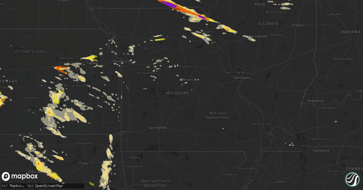
Hail Map in Missouri on June 17, 2017
Get this storm
June 17 map
$229
one time, instant access
Download today. No call, no setup
Keep the $229
Bought the map and want the full workflow? Apply the entire $229 to a subscription within 7 days. None of it is wasted.
Every map, not just this one
This buys you this map. Subscription and you get every map we run, in the markets you choose from a few cities to whole states to nationwide. Plus real-time alerts the moment a storm fires.
Contact data
Name, contact info, occupancy, even credit band for addresses in the footprint. You go from where it hit to who to call.
Become the source they trust
Unlimited branding weather history reports on demand. You already have the documented answer ready for the property owner, and you are the one who showed up with it.
Property data and RoofTrace estimates
Pull up any address you have got, its value and the exact code rules for that jurisdiction, straight from One Click Code. Then RoofTrace estimates the squares, pitch, and roof value, priced the way you price.
Storm reports in Missouri
Missouri
| Date | Description |
|---|---|
| 06/17/20171:20 AM CDT | Trees blown down. Large tree damaged a home and power lines. |
| 06/16/201711:50 PM CDT | 911 office reported trees... Powerlines... And some street light poles down. |
| 06/16/201711:36 PM CDT | Storm spotter reported a peak wind gust of 76 mph on his weather station. |
| 06/16/201711:25 PM CDT | Tree blown down in the city of columbia. Time estimated by radar. |
| 06/16/201711:01 PM CDT | Large tree down. |
| 06/16/201710:50 PM CDT | Powerlines down...large limbs and trees down. |
| 06/16/201710:47 PM CDT | Numerous large trees down throughout the city. Utility poles snapped in half. No known structural damage at this time. |
| 06/16/201710:42 PM CDT | Em relayed report of nickel to quarter size hail near fountain grove. |
| 06/16/201710:39 PM CDT | Trees blown down just northwest of hannibal |
| 06/16/201710:21 PM CDT | Trees blown down just west of palmyta. Time estimated by radar. |
| 06/16/201710:20 PM CDT | Saw 3 power flashes with this gust. |
| 06/16/201710:10 PM CDT | 10 inch diameter healthy maple tree snapped near the base. |
| 06/16/201710:10 PM CDT | At i-70 and route 13. |
| 06/16/20179:55 PM CDT | A local report indicates 70 MPH wind near OAK GROVE |
| 06/16/20179:54 PM CDT | Trees and powerlines down in odessa. Via twitter. |
| 06/16/20179:52 PM CDT | 6 in diameter tree limbs snapped. |
| 06/16/20179:45 PM CDT | 8 inch diameter healthy tree branch snapped. |
| 06/16/20179:44 PM CDT | Reported at lee's summit rd. And u.s. Hwy 40. |
| 06/16/20179:43 PM CDT | Vehicle shaking. Transformers blowing south of spotter's location. |
| 06/16/20179:40 PM CDT | A local report indicates 60 MPH wind near 2 NE BLUE SPRINGS |
| 06/16/20179:34 PM CDT | 50-60mph winds at u.s. Hwy 40 and phelps rd. |
| 06/16/20179:30 PM CDT | 4 in diameter trees snapped. |
| 06/16/20179:30 PM CDT | 3-4 inch diameter limbs down from healthy trees. |
| 06/16/20179:29 PM CDT | 4 to 6 inch trees blocking the road at 44th st. And phelps rd. |
| 06/16/20179:29 PM CDT | Multiple trees down. 61st st. And antioch rd. |
| 06/16/20179:25 PM CDT | A local report indicates 70 MPH wind near OAKWOOD PARK |
| 06/16/20179:25 PM CDT | Spotter saw transformers blow. Reported at worlds of fun. |
| 06/16/20179:25 PM CDT | A local report indicates 60 MPH wind near 3 SSW RAYTOWN |
| 06/16/20179:25 PM CDT | A local report indicates 60 MPH wind near 4 NNE OAKVIEW |
| 06/16/20179:25 PM CDT | Power flashes observed. Bp gas station sign across from kauffman stadium down. |
| 06/16/20179:19 PM CDT | Broadcast media reports damage to the boulevardia event in the west bottoms. The event had to close early due to damage sustained to tents... Fences... Etc. |
| 06/16/20179:18 PM CDT | At 93rd st. And north oak trfwy. |
| 06/16/20179:17 PM CDT | 50 to 60 mph est. Winds at 72nd st. And antioch rd. |
| 06/16/20179:15 PM CDT | Sporadic power outages in gladstone with limbs down. |
| 06/16/20179:15 PM CDT | Trees down at 61st st. And howard ave. |
| 06/16/20179:15 PM CDT | Numerous trees down between walmart and 66th terrace... Approximately 6-8 inches in diameter. |
| 06/16/20179:10 PM CDT | 10 inch diameter tree fell on a car. No one was injured. |
| 06/16/20179:07 PM CDT | Went on for 3-4 minutes. |
| 06/16/20179:05 PM CDT | Tree snapped in half. |
| 06/16/20178:59 PM CDT | South of platte city on highway n. |
| 06/16/20178:20 PM CDT | 12 inch tree fell down on three cars. No injuries reported. |
| 06/16/20178:20 PM CDT | A local report indicates 65 MPH wind near 2 S WYACONDA |
| 06/16/20178:10 PM CDT | Relayed from wfo st. Louis. Report was delayed the time of the event was estimated using radar. |
| 06/16/20177:57 PM CDT | 20 inch tree limbs broken from intense winds. |
| 06/16/20177:57 PM CDT | Hail may have been larger than golf balls. Broke out windows in multiple cars. |
| 06/16/20177:54 PM CDT | Time estimated from radar. |
| 06/16/20177:49 PM CDT | Wind driven hail up to baseball sized. Numerous windshields destroyed. |
| 06/16/20177:43 PM CDT | Accompanied by 50 mph winds. No damage noted. |
| 06/16/20177:43 PM CDT | Several tree branches and power lines down in town...time estimated from radar. |
| 06/16/20177:35 PM CDT | Delayed report. Time estimated from radar. Tree down on a powerline. |
| 06/16/20177:21 PM CDT | A local report indicates 1.75 inch wind near MEMPHIS |
| 06/16/20177:20 PM CDT | Via the internet |
| 06/16/20177:19 PM CDT | A local report indicates 60 MPH wind near MEMPHIS |
All States Impacted by Hail Map on June 17, 2017
Cities Impacted by Hail Map on June 17, 2017
- Wellston, OK
- Minneola, KS
- Warner, OK
- Elk Falls, KS
- New Boston, IL
- Rose, OK
- Deland, FL
- De Leon Springs, FL
- Locust Grove, OK
- Peggs, OK
- Russellville, MO
- Eugene, MO
- Ashland, KS
- Timewell, IL
- Mount Sterling, IL
- Toronto, KS
- Neal, KS
- Eureka, KS
- Virgil, KS
- Gorham, KS
- Hays, KS
- Victoria, KS
- Cimarron, KS
- Ensign, KS
- Montezuma, KS
- Kearney, MO
- Polo, MO
- Lathrop, MO
- Holt, MO
- Lawson, MO
- Orrick, MO
- Excelsior Springs, MO
- Henry, IL
- Topeka, KS
- Marshall, OK
- Crescent, OK
- Mulhall, OK
- Orlando, OK
- Fall River, KS
- Fredonia, KS
- Hamilton, KS
- Protection, KS
- Coldwater, KS
- Larned, KS
- Muskogee, OK
- Derby, KS
- Rose Hill, KS
- Afton, OK
- Glyndon, MN
- Hawley, MN
- Lake Park, MN
- Kahoka, MO
- Saint Patrick, MO
- Rossville, KS
- Silver Lake, KS
- Hoyt, KS
- Greensburg, KS
- Baldwin City, KS
- Haviland, KS
- Mullinville, KS
- Fowler, KS
- Cary, IL
- Rozel, KS
- Bluejacket, OK
- Welch, OK
- Miami, OK
- Latham, KS
- Alma, KS
- Dwight, KS
- Junction City, KS
- Chillicothe, MO
- Bethel, MO
- Shelbyville, MO
- Monroe City, MO
- Philadelphia, MO
- Emden, MO
- Palmyra, MO
- Hannibal, MO
- Andover, KS
- Mcconnell Afb, KS
- Wichita, KS
- Council Grove, KS
- Kingsland, GA
- Beardstown, IL
- Clayton, IL
- Great Bend, KS
- Ellinwood, KS
- Kansas City, MO
- Centerville, IA
- Plano, IA
- Mystic, IA
- Exline, IA
- Moulton, IA
- Illinois City, IL
- Muscatine, IA
- Perkins, MI
- Chapman, KS
- White City, KS
- Woodbine, KS
- Alta Vista, KS
- Ewing, MO
- Durham, MO
- Maywood, MO
- Newton, KS
- California, MO
- Burdett, KS
- Macksville, KS
- St John, KS
- Wilmore, KS
- Belpre, KS
- Lewis, KS
- Kinsley, KS
- Geuda Springs, KS
- Winfield, KS
- Oxford, KS
- Newkirk, OK
- Shidler, OK
- Maple City, KS
- Arkansas City, KS
- Mound City, KS
- Pleasanton, KS
- Leon, KS
- Beaumont, KS
- Rosalia, KS
- Piedmont, KS
- Bismarck, ND
- El Dorado, KS
- Versailles, IL
- Arenzville, IL
- Murray, KY
- Kirksey, KY
- Farmington, KY
- Mayfield, KY
- Menoken, ND
- Hanston, KS
- Beeler, KS
- Ness City, KS
- Jetmore, KS
- Manchester, OK
- Wyaconda, MO
- Gorin, MO
- Alexandria, MO
- Downing, MO
- Luray, MO
- West Point, IL
- Sutter, IL
- Arbela, MO
- Warsaw, IL
- Memphis, MO
- Copeland, KS
- Sublette, KS
- Douglass, KS
- Salina, OK
- Overland Park, KS
- Burns, KS
- Tahlequah, OK
- Proctor, OK
- Potwin, KS
- Fairbury, IL
- Atchison, KS
- Peabody, KS
- Florence, KS
- Whitewater, KS
- New London, IA
- Hunter, OK
- Garber, OK
- Fairmont, OK
- Enid, OK
- Deer River, MN
- Shelbina, MO
- Meadville, MO
- Laclede, MO
- Sumner, MO
- Brookfield, MO
- Hale, MO
- New Berlin, IL
- Chatham, IL
- Loami, IL
- Green Ridge, MO
- Knob Noster, MO
- Rush Center, KS
- Nekoma, KS
- Walker, KS
- Dacoma, OK
- Jet, OK
- Alexander, KS
- Cassoday, KS
- Wagoner, OK
- Pond Creek, OK
- Kremlin, OK
- Letts, IA
- Meriden, KS
- Delia, KS
- Saint Marys, KS
- Moran, KS
- Chandler, OK
- Sparks, OK
- Paw Paw, IL
- Earlville, IL
- Bronson, KS
- Hinesville, GA
- Udall, KS
- Mccurtain, OK
- Porum, OK
- Webbers Falls, OK
- Red Oak, OK
- Talihina, OK
- Wilburton, OK
- Gore, OK
- Vian, OK
- Stigler, OK
- Kinta, OK
- Wister, OK
- Victoria, IL
- Williamsfield, IL
- Longton, KS
- Rock, MI
- Checotah, OK
- Hulbert, OK
- Fort Gibson, OK
- Braggs, OK
- Chouteau, OK
- Ringwood, OK
- Lone Tree, IA
- Augusta, KS
- Kechi, KS
- Benton, KS
- Mulvane, KS
- Cambridge, KS
- Greenwich, KS
- Atlanta, KS
- Belle Plaine, KS
- Burden, KS
- Nichols, IA
- Butler, MO
- Paxico, KS
- Eskridge, KS
- Maple Hill, KS
- Joy, IL
- Novelty, MO
- Eucha, OK
- Colcord, OK
- Corydon, IA
- Bloomfield, IA
- Promise City, IA
- Millerton, IA
- Russell, IA
- Cincinnati, IA
- Udell, IA
- Douglas, OK
- Albia, IA
- Ottumwa, IA
- Hennessey, OK
- Guthrie, OK
- Pawnee, OK
- Morrison, OK
- Camp Point, IL
- Rushville, IL
- Golden, IL
- Huntsville, IL
- Coatsburg, IL
- Collyer, KS
- Newark, MO
- Lyndon, IL
- Sterling, IL
- Rock Falls, IL
- Harmon, IL
- Morrison, IL
- Pembroke, GA
- La Belle, MO
- Knox City, MO
- Humeston, IA
- Canton, MO
- Lancaster, MO
- Edina, MO
- Rutledge, MO
- Williamstown, MO
- Braymer, MO
- Ludlow, MO
- Cedar Point, KS
- Towanda, KS
- Marion, KS
- Quinton, OK
- Tecumseh, KS
- Lawrence, KS
- Berryton, KS
- Lecompton, KS
- Chenoa, IL
- Downs, KS
- Mount Vernon, GA
- Fort Scott, KS
- Shawnee, KS
- Toulon, IL
- Wyoming, IL
- Stafford, KS
- Spring Hill, KS
- Louisburg, KS
- Bucyrus, KS
- Taylor Ridge, IL
- Franklin, KS
- Pittsburg, KS
- Caldwell, KS
- Park Hill, OK
- Speer, IL
- Sparland, IL
- Hoisington, KS
- Americus, KS
- Pryor, OK
- Dighton, KS
- Hillsboro, KS
- Clinton, MO
- Ransom, KS
- Humboldt, KS
- Elsmore, KS
- Soperton, GA
- Tarrytown, GA
- Colfax, IL
- White Oak, GA
- Corydon, IN
- Walton, KS
- Strang, OK
- Spavinaw, OK
- Vinita, OK
- Duluth, MN
- Montpelier, IA
- Andalusia, IL
- West Liberty, IA
- Conesville, IA
- Riverside, IA
- Blue Grass, IA
- Reynolds, IL
- Natoma, KS
- Keosauqua, IA
- Hillsboro, IA
- Stockport, IA
- Bonaparte, IA
- Birmingham, IA
- Perry, OK
- Luther, OK
- Carney, OK
- Clarence, MO
- Anabel, MO
- Macon, MO
- Cohasset, MN
- Grand Rapids, MN
- Bovey, MN
- Meno, OK
- Gypsum, KS
- Durham, KS
- Wellington, KS
- Wheeling, MO
- Linneus, MO
- Strong City, KS
- Eddyville, IA
- Grain Valley, MO
- Buckner, MO
- Oak Grove, MO
- Napoleon, MO
- Herington, KS
- Burdick, KS
- Chillicothe, IA
- New London, MO
- Blue Mound, KS
- Centerville, KS
- Keota, OK
- Coyle, OK
- Meridian, OK
- Perkins, OK
- Olathe, KS
- Woodbine, GA
- Fulton, KS
- Prescott, KS
- Dixon, IL
- Amboy, IL
- Rushville, MO
- Utica, KS
- Amorita, OK
- Aledo, IL
- Waukomis, OK
- Hume, MO
- Cottonwood Falls, KS
- Bagley, MN
- Hughesville, MO
- Houstonia, MO
- Lahoma, OK
- Bluff City, KS
- Blackburn, MO
- Burlington, KS
- Le Roy, KS
- Marlette, MI
- Boston, GA
- Arcadia, KS
- Helena, OK
- Bucklin, MO
- Coal Valley, IL
- Milan, IL
- Kirkville, IA
- Snover, MI
- Decker, MI
- Maquon, IL
- Gilson, IL
- Independence, KS
- Nortonville, KS
- Lamont, OK
- Bucklin, KS
- Lebo, KS
- Stillman Valley, IL
- Platte City, MO
- Redfield, KS
- Uniontown, KS
- Big Cabin, OK
- Ketchum, OK
- Stillwater, OK
- Dearborn, MO
- Bradford, IL
- Ashland, IL
- Alexander, IL
- Canton, KS
- Galva, KS
- Garnett, KS
- Kincaid, KS
- Drummond, OK
- Welling, OK
- Dodge City, KS
- Cheney, KS
- Elk City, KS
- Billings, OK
- Ottawa, KS
- Mayville, MI
- Tampa, KS
- Eustis, FL
- Gilliam, MO
- Slater, MO
- Drexel, MO
- Waynesville, GA
- Waverly, GA
- Rock, KS
- Severy, KS
- Peck, KS
- Moline, KS
- Elbing, KS
- South Haven, KS
- Valley Center, KS
- Clearwater, KS
- Conway Springs, KS
- Maize, KS
- Elmdale, KS
- Haysville, KS
- Grenola, KS
- Lincolnville, KS
- Howard, KS
- Reading, KS
- Admire, KS
- Allen, KS
- Faucett, MO
- Saint Joseph, MO
- Blakesburg, IA
- Lexington, IL
- Gridley, IL
- Covington, OK
- Nashoba, OK
- Ollie, IA
- Marshall, MO
- Nelson, MO
- Chamois, MO
- Linn, MO
- Bonnots Mill, MO
- Emporia, KS
- Enterprise, KS
- Osage City, KS
- Bloomington, IN
- Cowgill, MO
- Maramec, OK
- Fort Leavenworth, KS
- Leavenworth, KS
- La Monte, MO
- Oktaha, OK
- Mapleton, KS
- Medford, OK
- Glasgow, MO
- Franklin, MO
- Beaver Dam, KY
- Cromwell, KY
- Sweet Springs, MO
- Yulee, FL
- Jacksonville, FL
- Callahan, FL
- Wathena, KS
- Troy, KS
- Livonia, MO
- Clinton, IA
- Fulton, IL
- Prague, OK
- Centertown, MO
- Lohman, MO
- Wilsey, KS
- Murdock, KS
- Kingman, KS
- Westphalia, KS
- Welda, KS
- Waverly, KS
- Concordia, MO
- Burlington, OK
- Valley Falls, KS
- Winchester, KS
- Oskaloosa, KS
- Adrian, MO
- Jefferson City, MO
- Windsor, MO
- Taylor, MO
- Pawnee Rock, KS
- Byers, KS
- Glenwood, MO
- Loraine, IL
- Pulaski, IA
- Coatsville, MO
- Bowen, IL
- Forrest, IL
- Waterman, IL
- Leland, IL
- Rocheport, MO
- New Franklin, MO
- Jay, OK
- Crystal Lake, IL
- Woodstock, IL
- Ralston, OK
- Folkston, GA
- Brant, MI
- Cleveland, MO
- Argyle, MO
- Bison, OK
- Ellington, MO
- Benton, KY
- Dexter, KS
- Anchor, IL
- Cooksville, IL
- Towanda, IL
- Cropsey, IL
- Harveyville, KS
- Burlingame, KS
- Edelstein, IL
- Chillicothe, IL
- La Prairie, IL
- Red Rock, OK
- Malta Bend, MO
- Liberty, MO
- Lacon, IL
- Melrose, IA
- Iola, KS
- Colony, KS
- Cullom, IL
- Pontiac, IL
- Douds, IA
- Nash, OK
- Tryon, OK
- Carrier, OK
- Aline, OK
- Goltry, OK
- Richmond, KS
- Lowpoint, IL
- Washburn, IL
- Roanoke, IL
- Benson, IL
- Metamora, IL
- Fairfax, OK
- De Kalb, MO
- Fort Stewart, GA
- La Fayette, IL
- Galva, IL
- Easton, KS
- Rantoul, KS
- Tonkawa, OK
- Matfield Green, KS
- Bazine, KS
- Baxter Springs, KS
- Galena, KS
- El Paso, IL
- Chadwick, IL
- Independence, MO
- Almo, KY
- Marland, OK
- Hull, IL
- Pengilly, MN
- Boonville, MO
- Buffalo, KS
- Yates Center, KS
- Jacksonville, IL
- Pleasant Plains, IL
- Brunswick, GA
- Hilliard, FL
- Nahunta, GA
- Hortense, GA
- Colwich, KS
- Goddard, KS
- Monticello, FL
- Ursa, IL
- Altona, IL
- Wakita, OK
- Osawatomie, KS
- Wellsville, KS
- Paola, KS
- Secor, IL
- Eureka, IL
- Norborne, MO
- Ozawkie, KS
- Perry, KS
- Grantville, KS
- Ingalls, KS
- Mendon, IL
- Wayland, MO
- Seymour, IA
- Martinsburg, IA
- Hedrick, IA
- Fremont, IA
- Marceline, MO
- Council Hill, OK
- Boynton, OK


