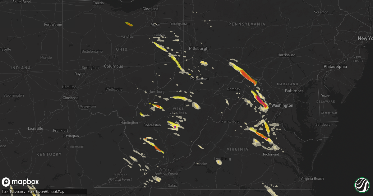
Hail Map in West Virginia on June 16, 2016
Get this storm
June 16 map
$229
one time, instant access
Download today. No call, no setup
Keep the $229
Bought the map and want the full workflow? Apply the entire $229 to a subscription within 7 days. None of it is wasted.
Every map, not just this one
This buys you this map. Subscription and you get every map we run, in the markets you choose from a few cities to whole states to nationwide. Plus real-time alerts the moment a storm fires.
Contact data
Name, contact info, occupancy, even credit band for addresses in the footprint. You go from where it hit to who to call.
Become the source they trust
Unlimited branding weather history reports on demand. You already have the documented answer ready for the property owner, and you are the one who showed up with it.
Property data and RoofTrace estimates
Pull up any address you have got, its value and the exact code rules for that jurisdiction, straight from One Click Code. Then RoofTrace estimates the squares, pitch, and roof value, priced the way you price.
Storm reports in West Virginia
West Virginia
| Date | Description |
|---|---|
| 06/16/20166:36 PM CDT | Tree down on rte 219 near renick wv. |
| 06/16/20166:35 PM CDT | Large trees down on unus road |
| 06/16/20166:05 PM CDT | Photo and video of hail received via social media. |
| 06/16/20166:02 PM CDT | A local report indicates 1.00 inch wind near 1 N SUMMERSVILLE |
| 06/16/20165:59 PM CDT | A tree was reported down at the intersection of east main street and corridor h. |
| 06/16/20165:54 PM CDT | A tree was reported down on upper scaggs run road near highway 55. |
| 06/16/20165:52 PM CDT | Tree down on house. |
| 06/16/20165:51 PM CDT | A local report indicates 65 MPH wind near SNOWSHOE |
| 06/16/20165:42 PM CDT | Numerous reoports of trees down along 219 between beverly and dailey |
| 06/16/20165:36 PM CDT | Numerous trees down in the circleville area. |
| 06/16/20165:36 PM CDT | A local report indicates 1.00 inch wind near CALVIN |
| 06/16/20165:22 PM CDT | Trees down on route 42 |
| 06/16/20165:21 PM CDT | Branches down in northern pocahontas county. Time estimated from radar. |
| 06/16/20165:20 PM CDT | Trees down near cherry falls off point mountain road in webster springs. Time est from radar |
| 06/16/20165:20 PM CDT | Tree down along point mountain road in webster springs. Blocking both lanes. Time est from radar |
| 06/16/20165:15 PM CDT | 2 trees down |
| 06/16/20165:15 PM CDT | Fell along lester highway north of mullins near hotchkiss |
| 06/16/20165:15 PM CDT | Roof blown off a porch in mill creek. |
| 06/16/20165:14 PM CDT | Numerous reoports of trees down along 219 between beverly and dailey |
| 06/16/20165:11 PM CDT | Numerous reports of trees down throughout the elkins area. Time estimated from radar. |
| 06/16/20165:00 PM CDT | 2 trees down |
| 06/16/20164:55 PM CDT | Usps employee reports power outages in vicinity of kelly mountain |
| 06/16/20164:48 PM CDT | Caller reported strong winds in town gusting between 50 to 60 mph |
| 06/16/20164:45 PM CDT | A local report indicates 1.00 inch wind near 4 SSE BALD KNOB |
| 06/16/20164:37 PM CDT | Numerous reports of trees down across barbour county including in philippi |
| 06/16/20164:30 PM CDT | Tree down |
| 06/16/20164:15 PM CDT | Tree down in reedsville |
| 06/16/20164:15 PM CDT | Time estimated from radar |
| 06/16/20164:13 PM CDT | Time estimated from radar |
| 06/16/20164:12 PM CDT | Viewer photo of a large tree uprooted on horner ave in clarksburg. Time est from radar |
| 06/16/20164:10 PM CDT | Some vehicle damage observed from golfball size hail. Time est from radar |
| 06/16/20164:10 PM CDT | Tree down |
| 06/16/20164:09 PM CDT | A local report indicates 1.00 inch wind near 1 W WESTON |
| 06/16/20164:09 PM CDT | Trees reported down in hazelgreen |
| 06/16/20164:06 PM CDT | Wind uprooted trees |
| 06/16/20164:03 PM CDT | Weatherbug station mrgnt at mountaineer field |
| 06/16/20164:01 PM CDT | Lewis county 911 reports numerous trees down throughout the county between weston and alum bridge. |
| 06/16/20164:00 PM CDT | Trees down on broadway ave |
| 06/16/20164:00 PM CDT | Several trees down along sabraton rd. |
| 06/16/20163:50 PM CDT | Trees... Poles... And wires down along little indian creek road. |
| 06/16/20163:49 PM CDT | A ef0 tornado occurrred on sierra farm road which downed and uprooted several large trees |
| 06/16/20163:44 PM CDT | A local report indicates 1.75 inch wind near 5 NW SPENCER |
| 06/16/20163:44 PM CDT | 4 to 6 diameter tree limbs were reported down at roane county golf course. |
| 06/16/20163:42 PM CDT | A local report indicates 1.25 inch wind near 2 SSW REEDY |
| 06/16/20163:40 PM CDT | A local report indicates 1.00 inch wind near ROBERTSBURG |
| 06/16/20163:21 PM CDT | Observed one mile east of silverton exit on i-77 |
| 06/16/20163:13 PM CDT | A local report indicates 1.00 inch wind near CHARLES TOWN |
| 06/16/20163:04 PM CDT | Golf ball sized hail. |
| 06/16/20163:02 PM CDT | Trees down along fairfax road. |
| 06/16/20163:02 PM CDT | Tree down in the 900 block of route 9 |
| 06/16/20161:29 PM CDT | A tree was reported down on lower cove run road. |
| 06/16/201610:52 AM CDT | Quarter size hail on days run rd. |
| 06/16/20169:37 AM CDT | . |
| 06/16/20169:36 AM CDT | . |
| 06/16/20169:35 AM CDT | Davis anemometer on a steel pole that bent after a 67 mph wind gust. |
| 06/15/20167:14 PM CDT | A tree was down blocking the roadway in the 4700 block of river road. |
| 06/15/20167:09 PM CDT | Tree limbs fell on power lines in the 800 block of jefferson avenue. |
| 06/15/20167:08 PM CDT | Trees down near hatfield bottoms along route 49 |
All States Impacted by Hail Map on June 16, 2016
Cities Impacted by Hail Map on June 16, 2016
- Kennedy, MN
- Solen, ND
- Shields, ND
- Flasher, ND
- Ruther Glen, VA
- Spotsylvania, VA
- Fredericksburg, VA
- Richardsville, VA
- Evington, VA
- Forest, VA
- Lynchburg, VA
- Rustburg, VA
- Birmingham, AL
- Sterrett, AL
- Badger, MN
- Greenbush, MN
- Warfordsburg, PA
- Artemas, PA
- Clearville, PA
- Little Orleans, MD
- Hancock, MD
- Pikeville, KY
- Robinson Creek, KY
- New Leipzig, ND
- Regent, ND
- Glen Ullin, ND
- Mott, ND
- Elgin, ND
- Sterling, ND
- Driscoll, ND
- Steele, ND
- Cottontown, TN
- Portland, TN
- Phillipsburg, MO
- Conway, MO
- Lebanon, MO
- Medora, ND
- Rhame, ND
- Belfield, ND
- Sentinel Butte, ND
- Uhrichsville, OH
- Sherrodsville, OH
- Dover, OH
- Mineral City, OH
- Strasburg, OH
- New Philadelphia, OH
- Bowerston, OH
- Dennison, OH
- Scio, OH
- Seaboard, NC
- Conway, NC
- Margarettsville, NC
- Emporia, VA
- Rich Square, NC
- Jackson, NC
- Woodland, NC
- Pleasant Hill, NC
- New Freeport, PA
- Stanardsville, VA
- Everett, PA
- Martinsburg, WV
- Stoystown, PA
- Berlin, PA
- Manns Choice, PA
- Central City, PA
- Berkeley Springs, WV
- Buffalo Mills, PA
- Hedgesville, WV
- Schellsburg, PA
- Bedford, PA
- Flintstone, MD
- Friedens, PA
- Cookeville, TN
- Hebron, ND
- Le Roy, WV
- Reedy, WV
- Spencer, WV
- Delbarton, WV
- Anniston, AL
- Louisa, VA
- Orange, VA
- Mineral, VA
- Partlow, VA
- Beaverdam, VA
- Bumpass, VA
- Peel, AR
- Lancaster, MN
- Roscoe, PA
- Stockdale, PA
- Elco, PA
- Allenport, PA
- Fayette City, PA
- Coal Center, PA
- Perryopolis, PA
- Brownsville, PA
- Grindstone, PA
- California, PA
- Sheyenne, ND
- Lagrange, GA
- West Point, GA
- Chapmanville, WV
- Mchenry, ND
- Campbellsville, KY
- Elk Horn, KY
- Columbia, KY
- Liberty, KY
- Scottsville, KY
- Bessemer, AL
- Pomona, KS
- Williamsburg, KS
- Overbrook, KS
- Baldwin, ND
- Mandan, ND
- Bismarck, ND
- Martin, ND
- Goodrich, ND
- Harvey, ND
- Ava, MO
- Dalton, OH
- Dundee, OH
- Mount Eaton, OH
- Apple Creek, OH
- Dillonvale, OH
- Adena, OH
- Saint Clairsville, OH
- Bridgeport, OH
- Cavalier, ND
- Rayland, OH
- Wellsburg, WV
- Brilliant, OH
- Beech Bottom, WV
- Nokesville, VA
- Seymour, MO
- Cadiz, OH
- Alexandria, AL
- Niagara, ND
- Robertsdale, AL
- Exira, IA
- Anita, IA
- Adair, IA
- Paris, VA
- Round Hill, VA
- Haymarket, VA
- Manassas, VA
- Catharpin, VA
- Bluemont, VA
- Berryville, VA
- Middleburg, VA
- Upperville, VA
- Gainesville, VA
- The Plains, VA
- New Salem, ND
- Tallassee, TN
- Berryton, KS
- Topeka, KS
- Tecumseh, KS
- Stoneboro, PA
- Clarks Mills, PA
- Summersville, WV
- Skippers, VA
- Ahoskie, NC
- Aulander, NC
- Garysburg, NC
- Urbana, MO
- Buffalo, MO
- Purcellville, VA
- Harpers Ferry, WV
- Markham, VA
- Delray, WV
- Augusta, WV
- Cameron, SC
- Lost Creek, WV
- Mount Clare, WV
- Norwood, MO
- Strasburg, VA
- Star Tannery, VA
- Menoken, ND
- Front Royal, VA
- Middletown, VA
- Pendleton, NC
- Perdido, AL
- Bay Minette, AL
- Coolville, OH
- Guysville, OH
- Richardton, ND
- Almont, ND
- Palestine, WV
- Sandyville, WV
- Jewett, OH
- Amidon, ND
- Neche, ND
- Oberon, ND
- Saint Michael, ND
- Elkwood, VA
- Rural Retreat, VA
- Atkins, VA
- Goldvein, VA
- Midland, VA
- Catlett, VA
- Sylacauga, AL
- Weogufka, AL
- Eldridge, MO
- Tunas, MO
- Crestview, FL
- Orangeburg, SC
- Wing, ND
- Regan, ND
- Gladstone, ND
- Drewryville, VA
- Salem, OH
- Beloit, OH
- Damascus, OH
- Mabie, WV
- Coalton, WV
- Ellamore, WV
- Fraziers Bottom, WV
- Buffalo, WV
- Southside, WV
- Leon, WV
- Mount Nebo, WV
- Quinwood, WV
- Hannah, ND
- Sarles, ND
- Akron, OH
- Tallmadge, OH
- Stephen, MN
- Camden, WV
- Weston, WV
- Black, AL
- Bonifay, FL
- Browder, KY
- Drakesboro, KY
- Dunmor, KY
- Belton, KY
- Craigsville, WV
- Richwood, WV
- Taylor, ND
- Dickinson, ND
- Claysville, PA
- Rapidan, VA
- Gordonsville, VA
- Doswell, VA
- Somerset, VA
- Covington, VA
- Mountain, ND
- Walhalla, ND
- Milton, ND
- Langdon, ND
- Bathgate, ND
- Maida, ND
- Hamilton, ND
- Lisbon, OH
- Wellsville, OH
- Clarkson, KY
- Leitchfield, KY
- Lefor, ND
- Long Lane, MO
- Wharton, WV
- Tuttle, ND
- Carson, ND
- Vanderbilt, PA
- Smock, PA
- Sugar Grove, VA
- Marion, VA
- Calvin, WV
- Clay, WV
- Nettie, WV
- Canvas, WV
- Ohatchee, AL
- Eagle Rock, VA
- Inwood, WV
- Mount Pleasant, OH
- Saint Anthony, ND
- Hewett, WV
- Clothier, WV
- Jeffrey, WV
- Bim, WV
- Yolyn, WV
- Amherstdale, WV
- Lake, WV
- Fairview, WV
- Franklin, KY
- Argyle, MN
- Wharncliffe, WV
- Glen Fork, WV
- Ravencliff, WV
- Oceana, WV
- Forest River, ND
- Fordland, MO
- Bruner, MO
- Ashford, AL
- Pansey, AL
- Franklin, GA
- Roopville, GA
- Rockford, AL
- Rogersville, PA
- Waynesburg, PA
- Holbrook, PA
- Mcville, ND
- Louisburg, MO
- Warwick, ND
- Maddock, ND
- Sandy Hook, VA
- Gum Spring, VA
- Kents Store, VA
- Goochland, VA
- Carrington, ND
- Leeds, AL
- Chelsea, AL
- Pelham, AL
- East Canton, OH
- Canton, OH
- Waynesburg, OH
- Mouthcard, KY
- Fedscreek, KY
- Marshall, VA
- Broad Run, VA
- Centreville, VA
- Warrenton, VA
- Chantilly, VA
- Aldie, VA
- Bristow, VA
- Stephenson, VA
- Boyce, VA
- Clear Brook, VA
- Tallmansville, WV
- Mill Creek, WV
- Buckhannon, WV
- Caneyville, KY
- Salineville, OH
- Talladega, AL
- Jasper, AL
- Charlottesville, VA
- Earlysville, VA
- Hamilton, GA
- Fortson, GA
- Raccoon, KY
- Elkhorn City, KY
- Shelbiana, KY
- Saint Vincent, MN
- Carbondale, KS
- Hazelton, ND
- Decker, MT
- Columbiana, AL
- Moundsville, WV
- Bremen, AL
- Granville, TN
- Baxter, TN
- Bloomington Springs, TN
- Red Boiling Springs, TN
- Lafayette, TN
- Gainesboro, TN
- Whitleyville, TN
- Pleasant Shade, TN
- Salem, WV
- Clarksburg, WV
- Climax, GA
- Townley, AL
- Carbon Hill, AL
- Devils Lake, ND
- Sykeston, ND
- Sardis, OH
- Point Marion, PA
- Dilliner, PA
- Bealeton, VA
- Meadowview, VA
- Glade Spring, VA
- Sandy Lake, PA
- Cross Timbers, MO
- Edwards, MO
- Moorefield, WV
- Oakwood, VA
- Grundy, VA
- Rowe, VA
- Vansant, VA
- Yellville, AR
- Mechanicsville, VA
- Manquin, VA
- Bradleyville, MO
- Stumpy Point, NC
- Manns Harbor, NC
- Manteo, NC
- Michigan, ND
- Pekin, ND
- Quenemo, KS
- Newell, PA
- Star Junction, PA
- Dunbar, PA
- Waltersburg, PA
- Uniontown, PA
- Haleyville, AL
- Greenville, GA
- Hogansville, GA
- Pine Mountain, GA
- Wheeling, WV
- Bellaire, OH
- Athens, OH
- New Rockford, ND
- Grace City, ND
- Cathay, ND
- Warsaw, MO
- Osceola, MO
- Wardensville, WV
- Yellow Spring, WV
- Hume, VA
- Milton, FL
- Kearneysville, WV
- Charles Town, WV
- Martins Ferry, OH
- Benwood, WV
- King William, VA
- Aylett, VA
- Glen Allen, VA
- Rockville, VA
- Montpelier, VA
- Chilhowie, VA
- Screven, GA
- Jacksonburg, WV
- Alma, WV
- Culpeper, VA
- Hardy, KY
- Forest Hills, KY
- Belfry, KY
- Williamson, WV
- McCarr, KY
- Iaeger, WV
- Ransom, KY
- Mohawk, WV
- Stopover, KY
- South Williamson, KY
- Matewan, WV
- Majestic, KY
- Hurley, VA
- Panther, WV
- Freeburn, KY
- Mill Run, PA
- Bowdon, ND
- Fessenden, ND
- Shenandoah Junction, WV
- Ranson, WV
- Hopedale, OH
- Amsterdam, OH
- Minto, ND
- Cameron, WV
- Forsyth, MT
- Williamsburg, KY
- Petersburg, ND
- Dahlen, ND
- Auburn, KY
- New Milton, WV
- West Union, WV
- Troy, WV
- Auburn, WV
- Jane Lew, WV
- Alum Bridge, WV
- Abingdon, VA
- Eglin Afb, FL
- Niceville, FL
- Odd, WV
- Beulah, ND
- Emlenton, PA
- Parker, PA
- Hanover, VA
- Moffit, ND
- Independence, WV
- Newburg, WV
- Morgantown, WV
- Saltville, VA
- Harpersville, AL
- Wilsonville, AL
- Friendsville, TN
- Farragut, TN
- Knoxville, TN
- Maryville, TN
- Louisville, TN
- Mcclusky, ND
- Madison, VA
- Valparaiso, FL
- Honaker, VA
- Lincoln, AL
- Sparta, MO
- Ozark, MO
- Fountain Run, KY
- Laurel Hill, FL
- Defuniak Springs, FL
- Hamilton, VA
- Leesburg, VA
- Knox, PA
- Washington, PA
- Glasgow, KY
- Austin, KY
- Lucas, KY
- Columbus, GA
- North Tazewell, VA
- White Sulphur Springs, WV
- Halliday, ND
- Walland, TN
- Roseau, MN
- Lorida, FL
- Theodosia, MO
- Oakland, AR
- Victor, WV
- Lecompton, KS
- Coxs Mills, WV
- French Creek, WV
- Valley Bend, WV
- Woodworth, ND
- Pettibone, ND
- Sumerduck, VA
- Cairo, GA
- Capon Bridge, WV
- South Heart, ND
- New England, ND
- Hendersonville, TN
- Cross Plains, TN
- Orlinda, TN
- White House, TN
- Gallatin, TN
- Knifley, KY
- Jamestown, KY
- Russell Springs, KY
- Remington, VA
- Lignum, VA
- Oslo, MN
- Manvel, ND
- Rockfield, KY
- Woodburn, KY
- Centertown, KY
- Rockport, KY
- Russellville, KY
- Central City, KY
- Island, KY
- Lewisburg, KY
- Beaver Dam, KY
- Carrollton, OH
- Gamaliel, KY
- Holland, KY
- Buffalo Valley, TN
- Carthage, TN
- Andalusia, AL
- Harold, KY
- Teaberry, KY
- Virgie, KY
- Beaver, KY
- Haysi, VA
- Swords Creek, VA
- Verbena, AL
- Hyndman, PA
- Fairhope, PA
- Shanksville, PA
- Denhoff, ND
- Hurdsfield, ND
- Gassaway, WV
- Frametown, WV
- Steele, KY
- Big Rock, VA
- Phyllis, KY
- Kimper, KY
- Lick Creek, KY
- Locust Grove, VA
- Unionville, VA
- Ivydale, WV
- Murfreesboro, NC
- Beach City, OH
- Leesville, OH
- Macks Creek, MO
- Rices Landing, PA
- Crucible, PA
- Winchester, VA
- Gordon, WV
- Madison, WV
- Lynn, AL
- Walker, WV
- Mineral Wells, WV
- Elizabeth, WV
- Raleigh, ND
- Brohard, WV
- Harrisville, WV
- Smithville, WV
- Big Springs, WV
- Macfarlan, WV
- Inkster, ND
- Pingree, ND
- Clinton, MO
- Valley, AL
- Lanett, AL
- Salem, AL
- Cusseta, AL
- Phenix City, AL
- Smiths Station, AL
- Nauvoo, AL
- Cedar Bluff, VA
- Wind Ridge, PA
- Glen Easton, WV
- Bowdon, GA
- Deepwater, MO
- Richlands, VA
- Raven, VA
- Grovespring, MO
- Milford, VA
- Bowling Green, VA
- Alpine, AL
- Perth, ND
- Rocklake, ND
- Stephens City, VA
- Everton, MO
- Woodford, VA
- Indianola, PA
- Cheswick, PA
- Allison Park, PA
- Pittsburgh, PA
- Doniphan, MO
- Sutton, WV
- Erbacon, WV
- Little Birch, WV
- Ochlocknee, GA
- Double Springs, AL
- Rhoadesville, VA
- Dunnville, KY
- Whitewood, VA
- Bandy, VA
- Jewell Ridge, VA
- Fordville, ND
- Roanoke, VA
- Couch, MO
- Dellroy, OH
- Magnolia, OH
- Sandyville, OH
- Bolivar, OH
- East Sparta, OH
- Webster Springs, WV
- Cowen, WV
- Robinson, ND
- Dawson, ND
- Caldwell, OH
- Crawford, WV
- Walkersville, WV
- Adrian, WV
- Horner, WV
- Navarre, FL
- Annapolis, MO
- Tioga, WV
- Fenwick, WV
- Nanjemoy, MD
- Stafford, VA
- King George, VA
- Lawton, ND
- Brocket, ND
- Damascus, VA
- Bristol, TN
- Dora, AL
- Warrior, AL
- Empire, AL
- Franklin, WV
- Brandywine, WV
- Adamsville, AL
- Mulga, AL
- Nixa, MO
- Tolna, ND
- Berea, WV
- Mountain Grove, MO
- Bloomingdale, OH
- Steubenville, OH
- Ottawa, KS
- Lawrence, KS
- Linden, VA
- Chester Gap, VA
- Huntly, VA
- Marion, KY
- Ashland, VA
- Rogersville, MO
- Flomaton, AL
- Lashmeet, WV
- Matoaka, WV
- Hallock, MN
- Lake Bronson, MN
- Camilla, GA
- Thomasville, GA
- Whigham, GA
- Columbia, VA
- Maidsville, WV
- Pursglove, WV
- Osage, WV
- Burgettstown, PA
- Avella, PA
- Clinchco, VA
- Clintwood, VA
- Parrish, AL
- Oakman, AL
- Mansfield, MO
- Isabella, MO
- Mitchells, VA
- Burr Hill, VA
- Stevensburg, VA
- Goodwater, AL
- Rimersburg, PA
- Dodge, ND
- Holt, FL
- Donaldson, MN
- Oldfield, MO
- Springfield, MO
- Chadwick, MO
- Graff, MO
- Grafton, ND
- Red House, WV
- Niangua, MO
- Lillian, AL
- Port Royal, VA
- Brewton, AL
- Crozet, VA
- Salem, VA
- Rochester, KY
- Braddock, ND
- Cragford, AL
- Alexander City, AL
- Ashland, AL
- Glen Dale, WV
- Adger, AL
- Windyville, MO
- Drayton, ND
- Bethesda, OH
- Barnesville, OH
- Warm Springs, GA
- Hanceville, AL
- Brinson, GA
- Lafayette, AL
- Bethany, WV
- Mogadore, OH
- Logan, WV
- Stollings, WV
- Charleston, WV
- Liberty, WV
- Great Cacapon, WV
- Newnan, GA
- Barboursville, VA
- Ruckersville, VA
- Rochelle, VA
- Aroda, VA
- Greensboro, PA
- Garards Fort, PA
- Carmichaels, PA
- Bisbee, ND
- Perry, KS
- Navarre, OH
- Massillon, OH
- Glenfield, ND
- Sterling, VA
- Center Point, WV
- Alton, MO
- Rhodell, WV
- Maben, WV
- Pecks Mill, WV
- Danville, WV
- Seth, WV
- Saulsville, WV
- Twilight, WV
- Bob White, WV
- Cyclone, WV
- Amigo, WV
- Mullens, WV
- Chester, WV
- Bridgeport, WV
- Flemington, WV
- Windber, PA
- Cairnbrook, PA
- New Paris, PA
- Hooversville, PA
- Freeman, VA
- Cedar Key, FL
- Daviston, AL
- Ripley, WV
- Gandeeville, WV
- Gay, WV
- Townsend, TN
- Alcoa, TN
- Tifton, GA
- Hartville, MO
- Boykins, VA
- Cordova, AL
- Fisher, WV
- Mathias, WV
- Swiss, WV
- Drennen, WV
- Duck, WV
- Warroad, MN
- Lowell, OH
- Waterford, OH
- Whitesville, WV
- Richmond, KS
- Garnett, KS
- Blacksville, WV
- Minerva, OH
- Dadeville, AL
- Smithfield, OH
- Aleppo, PA
- Spraggs, PA
- Dallas, WV
- Odenville, AL
- Childersburg, AL
- Falling Waters, WV
- Bloomingdale, MI
- Bangor, MI
- South Haven, MI
- Grand Junction, MI
- Gobles, MI
- Paw Paw, MI
- Lawton, MI
- Mattawan, MI
- Schoolcraft, MI
- Milan, MI
- Saline, MI
- Willis, MI
- Ypsilanti, MI
- Tappen, ND
- Baker, MT
- Golva, ND
- Piedmont, AL
- Centre, AL
- Ravenswood, WV
- Apple Grove, WV
- Slab Fork, WV
- Glen Rogers, WV
- Wana, WV
- Brave, PA
- Nova, OH
- North Fairfield, OH
- Norwalk, OH
- Greenwich, OH
- New London, OH
- Sullivan, OH


