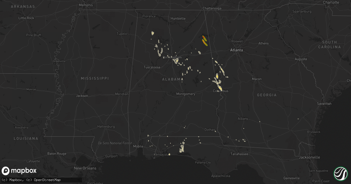
Hail Map in Alabama on June 16, 2016
Get this storm
June 16 map
$229
one time, instant access
Download today. No call, no setup
Keep the $229
Bought the map and want the full workflow? Apply the entire $229 to a subscription within 7 days. None of it is wasted.
Every map, not just this one
This buys you this map. Subscription and you get every map we run, in the markets you choose from a few cities to whole states to nationwide. Plus real-time alerts the moment a storm fires.
Contact data
Name, contact info, occupancy, even credit band for addresses in the footprint. You go from where it hit to who to call.
Become the source they trust
Unlimited branding weather history reports on demand. You already have the documented answer ready for the property owner, and you are the one who showed up with it.
Property data and RoofTrace estimates
Pull up any address you have got, its value and the exact code rules for that jurisdiction, straight from One Click Code. Then RoofTrace estimates the squares, pitch, and roof value, priced the way you price.
Storm reports in Alabama
Alabama
| Date | Description |
|---|---|
| 06/16/20165:46 PM CDT | Few trees down across cow pens road north of new site. Motor vehicle accident with no injuries reported. Estimated 40 to 50 mph winds. Location approximate. Time estima |
| 06/16/20165:27 PM CDT | Tree down on house along the bessemer superhighway. Minimal roof damage reported. Estimated 40 to 50 mph winds. Location approximate. Time estimated by radar. |
| 06/16/20165:25 PM CDT | Tree down in cahaba valley trace. |
| 06/16/20165:21 PM CDT | Tree down across county road 14 in shelby county. Location approximate. Time estimated by radar. |
| 06/16/20164:55 PM CDT | Power lines down near intersection of rex lake road and bailey road. |
| 06/16/20164:20 PM CDT | Tree down off of dearmanville drive in anniston. Estimated 40 to 50 mph winds. |
| 06/16/20164:04 PM CDT | Tree down on house along avenue f. Estimated 40 to 50 mph winds. Location approximate. Time estimated by radar. |
| 06/16/20161:40 PM CDT | Trees were blown down in the gordon area |
| 06/16/20161:35 PM CDT | Tree down on state highway 10 east between mile markers 229 and 230. |
| 06/16/20161:30 PM CDT | Power lines were blown down in the columbia area |
| 06/16/20161:16 PM CDT | Tree on road near south county rd 33 and edsel deese rd. |
| 06/15/20167:40 PM CDT | Large tree limbs down near lloyds ln at hampton oaks dr |
All States Impacted by Hail Map on June 16, 2016
Cities Impacted by Hail Map on June 16, 2016
- Kennedy, MN
- Solen, ND
- Shields, ND
- Flasher, ND
- Ruther Glen, VA
- Spotsylvania, VA
- Fredericksburg, VA
- Richardsville, VA
- Evington, VA
- Forest, VA
- Lynchburg, VA
- Rustburg, VA
- Birmingham, AL
- Sterrett, AL
- Badger, MN
- Greenbush, MN
- Warfordsburg, PA
- Artemas, PA
- Clearville, PA
- Little Orleans, MD
- Hancock, MD
- Pikeville, KY
- Robinson Creek, KY
- New Leipzig, ND
- Regent, ND
- Glen Ullin, ND
- Mott, ND
- Elgin, ND
- Sterling, ND
- Driscoll, ND
- Steele, ND
- Cottontown, TN
- Portland, TN
- Phillipsburg, MO
- Conway, MO
- Lebanon, MO
- Medora, ND
- Rhame, ND
- Belfield, ND
- Sentinel Butte, ND
- Uhrichsville, OH
- Sherrodsville, OH
- Dover, OH
- Mineral City, OH
- Strasburg, OH
- New Philadelphia, OH
- Bowerston, OH
- Dennison, OH
- Scio, OH
- Seaboard, NC
- Conway, NC
- Margarettsville, NC
- Emporia, VA
- Rich Square, NC
- Jackson, NC
- Woodland, NC
- Pleasant Hill, NC
- New Freeport, PA
- Stanardsville, VA
- Everett, PA
- Martinsburg, WV
- Stoystown, PA
- Berlin, PA
- Manns Choice, PA
- Central City, PA
- Berkeley Springs, WV
- Buffalo Mills, PA
- Hedgesville, WV
- Schellsburg, PA
- Bedford, PA
- Flintstone, MD
- Friedens, PA
- Cookeville, TN
- Hebron, ND
- Le Roy, WV
- Reedy, WV
- Spencer, WV
- Delbarton, WV
- Anniston, AL
- Louisa, VA
- Orange, VA
- Mineral, VA
- Partlow, VA
- Beaverdam, VA
- Bumpass, VA
- Peel, AR
- Lancaster, MN
- Roscoe, PA
- Stockdale, PA
- Elco, PA
- Allenport, PA
- Fayette City, PA
- Coal Center, PA
- Perryopolis, PA
- Brownsville, PA
- Grindstone, PA
- California, PA
- Sheyenne, ND
- Lagrange, GA
- West Point, GA
- Chapmanville, WV
- Mchenry, ND
- Campbellsville, KY
- Elk Horn, KY
- Columbia, KY
- Liberty, KY
- Scottsville, KY
- Bessemer, AL
- Pomona, KS
- Williamsburg, KS
- Overbrook, KS
- Baldwin, ND
- Mandan, ND
- Bismarck, ND
- Martin, ND
- Goodrich, ND
- Harvey, ND
- Ava, MO
- Dalton, OH
- Dundee, OH
- Mount Eaton, OH
- Apple Creek, OH
- Dillonvale, OH
- Adena, OH
- Saint Clairsville, OH
- Bridgeport, OH
- Cavalier, ND
- Rayland, OH
- Wellsburg, WV
- Brilliant, OH
- Beech Bottom, WV
- Nokesville, VA
- Seymour, MO
- Cadiz, OH
- Alexandria, AL
- Niagara, ND
- Robertsdale, AL
- Exira, IA
- Anita, IA
- Adair, IA
- Paris, VA
- Round Hill, VA
- Haymarket, VA
- Manassas, VA
- Catharpin, VA
- Bluemont, VA
- Berryville, VA
- Middleburg, VA
- Upperville, VA
- Gainesville, VA
- The Plains, VA
- New Salem, ND
- Tallassee, TN
- Berryton, KS
- Topeka, KS
- Tecumseh, KS
- Stoneboro, PA
- Clarks Mills, PA
- Summersville, WV
- Skippers, VA
- Ahoskie, NC
- Aulander, NC
- Garysburg, NC
- Urbana, MO
- Buffalo, MO
- Purcellville, VA
- Harpers Ferry, WV
- Markham, VA
- Delray, WV
- Augusta, WV
- Cameron, SC
- Lost Creek, WV
- Mount Clare, WV
- Norwood, MO
- Strasburg, VA
- Star Tannery, VA
- Menoken, ND
- Front Royal, VA
- Middletown, VA
- Pendleton, NC
- Perdido, AL
- Bay Minette, AL
- Coolville, OH
- Guysville, OH
- Richardton, ND
- Almont, ND
- Palestine, WV
- Sandyville, WV
- Jewett, OH
- Amidon, ND
- Neche, ND
- Oberon, ND
- Saint Michael, ND
- Elkwood, VA
- Rural Retreat, VA
- Atkins, VA
- Goldvein, VA
- Midland, VA
- Catlett, VA
- Sylacauga, AL
- Weogufka, AL
- Eldridge, MO
- Tunas, MO
- Crestview, FL
- Orangeburg, SC
- Wing, ND
- Regan, ND
- Gladstone, ND
- Drewryville, VA
- Salem, OH
- Beloit, OH
- Damascus, OH
- Mabie, WV
- Coalton, WV
- Ellamore, WV
- Fraziers Bottom, WV
- Buffalo, WV
- Southside, WV
- Leon, WV
- Mount Nebo, WV
- Quinwood, WV
- Hannah, ND
- Sarles, ND
- Akron, OH
- Tallmadge, OH
- Stephen, MN
- Camden, WV
- Weston, WV
- Black, AL
- Bonifay, FL
- Browder, KY
- Drakesboro, KY
- Dunmor, KY
- Belton, KY
- Craigsville, WV
- Richwood, WV
- Taylor, ND
- Dickinson, ND
- Claysville, PA
- Rapidan, VA
- Gordonsville, VA
- Doswell, VA
- Somerset, VA
- Covington, VA
- Mountain, ND
- Walhalla, ND
- Milton, ND
- Langdon, ND
- Bathgate, ND
- Maida, ND
- Hamilton, ND
- Lisbon, OH
- Wellsville, OH
- Clarkson, KY
- Leitchfield, KY
- Lefor, ND
- Long Lane, MO
- Wharton, WV
- Tuttle, ND
- Carson, ND
- Vanderbilt, PA
- Smock, PA
- Sugar Grove, VA
- Marion, VA
- Calvin, WV
- Clay, WV
- Nettie, WV
- Canvas, WV
- Ohatchee, AL
- Eagle Rock, VA
- Inwood, WV
- Mount Pleasant, OH
- Saint Anthony, ND
- Hewett, WV
- Clothier, WV
- Jeffrey, WV
- Bim, WV
- Yolyn, WV
- Amherstdale, WV
- Lake, WV
- Fairview, WV
- Franklin, KY
- Argyle, MN
- Wharncliffe, WV
- Glen Fork, WV
- Ravencliff, WV
- Oceana, WV
- Forest River, ND
- Fordland, MO
- Bruner, MO
- Ashford, AL
- Pansey, AL
- Franklin, GA
- Roopville, GA
- Rockford, AL
- Rogersville, PA
- Waynesburg, PA
- Holbrook, PA
- Mcville, ND
- Louisburg, MO
- Warwick, ND
- Maddock, ND
- Sandy Hook, VA
- Gum Spring, VA
- Kents Store, VA
- Goochland, VA
- Carrington, ND
- Leeds, AL
- Chelsea, AL
- Pelham, AL
- East Canton, OH
- Canton, OH
- Waynesburg, OH
- Mouthcard, KY
- Fedscreek, KY
- Marshall, VA
- Broad Run, VA
- Centreville, VA
- Warrenton, VA
- Chantilly, VA
- Aldie, VA
- Bristow, VA
- Stephenson, VA
- Boyce, VA
- Clear Brook, VA
- Tallmansville, WV
- Mill Creek, WV
- Buckhannon, WV
- Caneyville, KY
- Salineville, OH
- Talladega, AL
- Jasper, AL
- Charlottesville, VA
- Earlysville, VA
- Hamilton, GA
- Fortson, GA
- Raccoon, KY
- Elkhorn City, KY
- Shelbiana, KY
- Saint Vincent, MN
- Carbondale, KS
- Hazelton, ND
- Decker, MT
- Columbiana, AL
- Moundsville, WV
- Bremen, AL
- Granville, TN
- Baxter, TN
- Bloomington Springs, TN
- Red Boiling Springs, TN
- Lafayette, TN
- Gainesboro, TN
- Whitleyville, TN
- Pleasant Shade, TN
- Salem, WV
- Clarksburg, WV
- Climax, GA
- Townley, AL
- Carbon Hill, AL
- Devils Lake, ND
- Sykeston, ND
- Sardis, OH
- Point Marion, PA
- Dilliner, PA
- Bealeton, VA
- Meadowview, VA
- Glade Spring, VA
- Sandy Lake, PA
- Cross Timbers, MO
- Edwards, MO
- Moorefield, WV
- Oakwood, VA
- Grundy, VA
- Rowe, VA
- Vansant, VA
- Yellville, AR
- Mechanicsville, VA
- Manquin, VA
- Bradleyville, MO
- Stumpy Point, NC
- Manns Harbor, NC
- Manteo, NC
- Michigan, ND
- Pekin, ND
- Quenemo, KS
- Newell, PA
- Star Junction, PA
- Dunbar, PA
- Waltersburg, PA
- Uniontown, PA
- Haleyville, AL
- Greenville, GA
- Hogansville, GA
- Pine Mountain, GA
- Wheeling, WV
- Bellaire, OH
- Athens, OH
- New Rockford, ND
- Grace City, ND
- Cathay, ND
- Warsaw, MO
- Osceola, MO
- Wardensville, WV
- Yellow Spring, WV
- Hume, VA
- Milton, FL
- Kearneysville, WV
- Charles Town, WV
- Martins Ferry, OH
- Benwood, WV
- King William, VA
- Aylett, VA
- Glen Allen, VA
- Rockville, VA
- Montpelier, VA
- Chilhowie, VA
- Screven, GA
- Jacksonburg, WV
- Alma, WV
- Culpeper, VA
- Hardy, KY
- Forest Hills, KY
- Belfry, KY
- Williamson, WV
- McCarr, KY
- Iaeger, WV
- Ransom, KY
- Mohawk, WV
- Stopover, KY
- South Williamson, KY
- Matewan, WV
- Majestic, KY
- Hurley, VA
- Panther, WV
- Freeburn, KY
- Mill Run, PA
- Bowdon, ND
- Fessenden, ND
- Shenandoah Junction, WV
- Ranson, WV
- Hopedale, OH
- Amsterdam, OH
- Minto, ND
- Cameron, WV
- Forsyth, MT
- Williamsburg, KY
- Petersburg, ND
- Dahlen, ND
- Auburn, KY
- New Milton, WV
- West Union, WV
- Troy, WV
- Auburn, WV
- Jane Lew, WV
- Alum Bridge, WV
- Abingdon, VA
- Eglin Afb, FL
- Niceville, FL
- Odd, WV
- Beulah, ND
- Emlenton, PA
- Parker, PA
- Hanover, VA
- Moffit, ND
- Independence, WV
- Newburg, WV
- Morgantown, WV
- Saltville, VA
- Harpersville, AL
- Wilsonville, AL
- Friendsville, TN
- Farragut, TN
- Knoxville, TN
- Maryville, TN
- Louisville, TN
- Mcclusky, ND
- Madison, VA
- Valparaiso, FL
- Honaker, VA
- Lincoln, AL
- Sparta, MO
- Ozark, MO
- Fountain Run, KY
- Laurel Hill, FL
- Defuniak Springs, FL
- Hamilton, VA
- Leesburg, VA
- Knox, PA
- Washington, PA
- Glasgow, KY
- Austin, KY
- Lucas, KY
- Columbus, GA
- North Tazewell, VA
- White Sulphur Springs, WV
- Halliday, ND
- Walland, TN
- Roseau, MN
- Lorida, FL
- Theodosia, MO
- Oakland, AR
- Victor, WV
- Lecompton, KS
- Coxs Mills, WV
- French Creek, WV
- Valley Bend, WV
- Woodworth, ND
- Pettibone, ND
- Sumerduck, VA
- Cairo, GA
- Capon Bridge, WV
- South Heart, ND
- New England, ND
- Hendersonville, TN
- Cross Plains, TN
- Orlinda, TN
- White House, TN
- Gallatin, TN
- Knifley, KY
- Jamestown, KY
- Russell Springs, KY
- Remington, VA
- Lignum, VA
- Oslo, MN
- Manvel, ND
- Rockfield, KY
- Woodburn, KY
- Centertown, KY
- Rockport, KY
- Russellville, KY
- Central City, KY
- Island, KY
- Lewisburg, KY
- Beaver Dam, KY
- Carrollton, OH
- Gamaliel, KY
- Holland, KY
- Buffalo Valley, TN
- Carthage, TN
- Andalusia, AL
- Harold, KY
- Teaberry, KY
- Virgie, KY
- Beaver, KY
- Haysi, VA
- Swords Creek, VA
- Verbena, AL
- Hyndman, PA
- Fairhope, PA
- Shanksville, PA
- Denhoff, ND
- Hurdsfield, ND
- Gassaway, WV
- Frametown, WV
- Steele, KY
- Big Rock, VA
- Phyllis, KY
- Kimper, KY
- Lick Creek, KY
- Locust Grove, VA
- Unionville, VA
- Ivydale, WV
- Murfreesboro, NC
- Beach City, OH
- Leesville, OH
- Macks Creek, MO
- Rices Landing, PA
- Crucible, PA
- Winchester, VA
- Gordon, WV
- Madison, WV
- Lynn, AL
- Walker, WV
- Mineral Wells, WV
- Elizabeth, WV
- Raleigh, ND
- Brohard, WV
- Harrisville, WV
- Smithville, WV
- Big Springs, WV
- Macfarlan, WV
- Inkster, ND
- Pingree, ND
- Clinton, MO
- Valley, AL
- Lanett, AL
- Salem, AL
- Cusseta, AL
- Phenix City, AL
- Smiths Station, AL
- Nauvoo, AL
- Cedar Bluff, VA
- Wind Ridge, PA
- Glen Easton, WV
- Bowdon, GA
- Deepwater, MO
- Richlands, VA
- Raven, VA
- Grovespring, MO
- Milford, VA
- Bowling Green, VA
- Alpine, AL
- Perth, ND
- Rocklake, ND
- Stephens City, VA
- Everton, MO
- Woodford, VA
- Indianola, PA
- Cheswick, PA
- Allison Park, PA
- Pittsburgh, PA
- Doniphan, MO
- Sutton, WV
- Erbacon, WV
- Little Birch, WV
- Ochlocknee, GA
- Double Springs, AL
- Rhoadesville, VA
- Dunnville, KY
- Whitewood, VA
- Bandy, VA
- Jewell Ridge, VA
- Fordville, ND
- Roanoke, VA
- Couch, MO
- Dellroy, OH
- Magnolia, OH
- Sandyville, OH
- Bolivar, OH
- East Sparta, OH
- Webster Springs, WV
- Cowen, WV
- Robinson, ND
- Dawson, ND
- Caldwell, OH
- Crawford, WV
- Walkersville, WV
- Adrian, WV
- Horner, WV
- Navarre, FL
- Annapolis, MO
- Tioga, WV
- Fenwick, WV
- Nanjemoy, MD
- Stafford, VA
- King George, VA
- Lawton, ND
- Brocket, ND
- Damascus, VA
- Bristol, TN
- Dora, AL
- Warrior, AL
- Empire, AL
- Franklin, WV
- Brandywine, WV
- Adamsville, AL
- Mulga, AL
- Nixa, MO
- Tolna, ND
- Berea, WV
- Mountain Grove, MO
- Bloomingdale, OH
- Steubenville, OH
- Ottawa, KS
- Lawrence, KS
- Linden, VA
- Chester Gap, VA
- Huntly, VA
- Marion, KY
- Ashland, VA
- Rogersville, MO
- Flomaton, AL
- Lashmeet, WV
- Matoaka, WV
- Hallock, MN
- Lake Bronson, MN
- Camilla, GA
- Thomasville, GA
- Whigham, GA
- Columbia, VA
- Maidsville, WV
- Pursglove, WV
- Osage, WV
- Burgettstown, PA
- Avella, PA
- Clinchco, VA
- Clintwood, VA
- Parrish, AL
- Oakman, AL
- Mansfield, MO
- Isabella, MO
- Mitchells, VA
- Burr Hill, VA
- Stevensburg, VA
- Goodwater, AL
- Rimersburg, PA
- Dodge, ND
- Holt, FL
- Donaldson, MN
- Oldfield, MO
- Springfield, MO
- Chadwick, MO
- Graff, MO
- Grafton, ND
- Red House, WV
- Niangua, MO
- Lillian, AL
- Port Royal, VA
- Brewton, AL
- Crozet, VA
- Salem, VA
- Rochester, KY
- Braddock, ND
- Cragford, AL
- Alexander City, AL
- Ashland, AL
- Glen Dale, WV
- Adger, AL
- Windyville, MO
- Drayton, ND
- Bethesda, OH
- Barnesville, OH
- Warm Springs, GA
- Hanceville, AL
- Brinson, GA
- Lafayette, AL
- Bethany, WV
- Mogadore, OH
- Logan, WV
- Stollings, WV
- Charleston, WV
- Liberty, WV
- Great Cacapon, WV
- Newnan, GA
- Barboursville, VA
- Ruckersville, VA
- Rochelle, VA
- Aroda, VA
- Greensboro, PA
- Garards Fort, PA
- Carmichaels, PA
- Bisbee, ND
- Perry, KS
- Navarre, OH
- Massillon, OH
- Glenfield, ND
- Sterling, VA
- Center Point, WV
- Alton, MO
- Rhodell, WV
- Maben, WV
- Pecks Mill, WV
- Danville, WV
- Seth, WV
- Saulsville, WV
- Twilight, WV
- Bob White, WV
- Cyclone, WV
- Amigo, WV
- Mullens, WV
- Chester, WV
- Bridgeport, WV
- Flemington, WV
- Windber, PA
- Cairnbrook, PA
- New Paris, PA
- Hooversville, PA
- Freeman, VA
- Cedar Key, FL
- Daviston, AL
- Ripley, WV
- Gandeeville, WV
- Gay, WV
- Townsend, TN
- Alcoa, TN
- Tifton, GA
- Hartville, MO
- Boykins, VA
- Cordova, AL
- Fisher, WV
- Mathias, WV
- Swiss, WV
- Drennen, WV
- Duck, WV
- Warroad, MN
- Lowell, OH
- Waterford, OH
- Whitesville, WV
- Richmond, KS
- Garnett, KS
- Blacksville, WV
- Minerva, OH
- Dadeville, AL
- Smithfield, OH
- Aleppo, PA
- Spraggs, PA
- Dallas, WV
- Odenville, AL
- Childersburg, AL
- Falling Waters, WV
- Bloomingdale, MI
- Bangor, MI
- South Haven, MI
- Grand Junction, MI
- Gobles, MI
- Paw Paw, MI
- Lawton, MI
- Mattawan, MI
- Schoolcraft, MI
- Milan, MI
- Saline, MI
- Willis, MI
- Ypsilanti, MI
- Tappen, ND
- Baker, MT
- Golva, ND
- Piedmont, AL
- Centre, AL
- Ravenswood, WV
- Apple Grove, WV
- Slab Fork, WV
- Glen Rogers, WV
- Wana, WV
- Brave, PA
- Nova, OH
- North Fairfield, OH
- Norwalk, OH
- Greenwich, OH
- New London, OH
- Sullivan, OH


