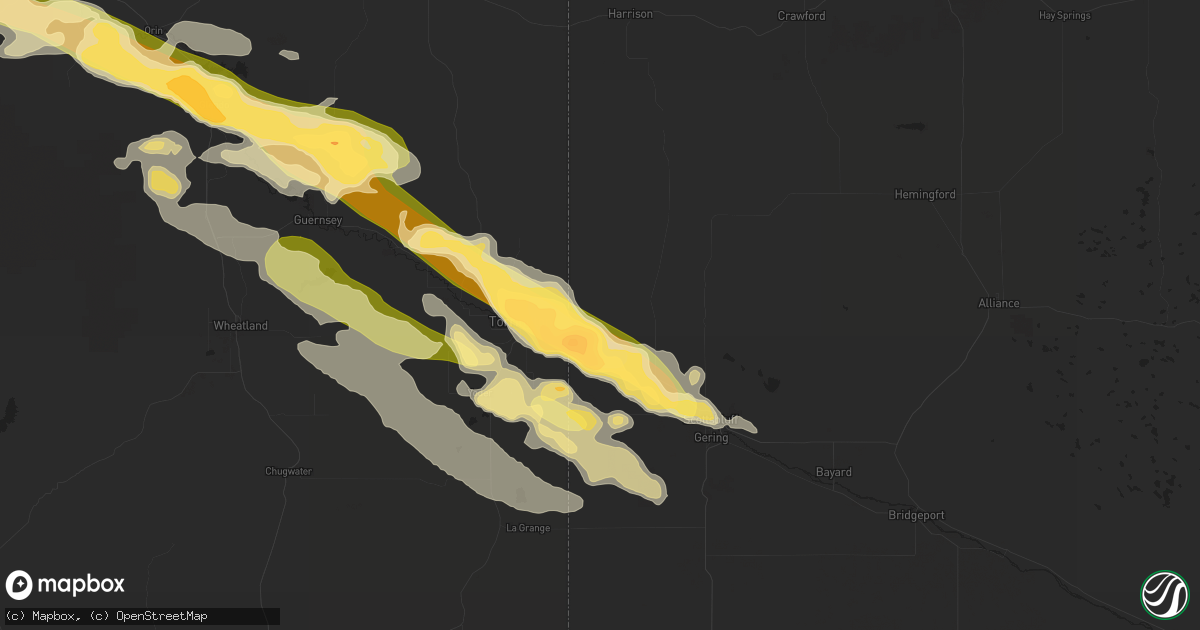
Hail Map in Morrill, NE on June 16, 2015
Get this storm
June 16 map
$229
one time, instant access
Download today. No call, no setup
Keep the $229
Bought the map and want the full workflow? Apply the entire $229 to a subscription within 7 days. None of it is wasted.
Every map, not just this one
This buys you this map. Subscription and you get every map we run, in the markets you choose from a few cities to whole states to nationwide. Plus real-time alerts the moment a storm fires.
Contact data
Name, contact info, occupancy, even credit band for addresses in the footprint. You go from where it hit to who to call.
Become the source they trust
Unlimited branding weather history reports on demand. You already have the documented answer ready for the property owner, and you are the one who showed up with it.
Property data and RoofTrace estimates
Pull up any address you have got, its value and the exact code rules for that jurisdiction, straight from One Click Code. Then RoofTrace estimates the squares, pitch, and roof value, priced the way you price.
Storm reports in Morrill, NE
Morrill, NE
| Date | Description |
|---|---|
| 06/16/20156:00 PM CDT | Duration 30 minutes. |
| 06/16/20156:00 PM CDT | Hail accumulated 3 inches deep. Bark stripped off trees. Duration 30 minutes. |
| 06/16/20156:00 PM CDT | Duration 45 minutes. Property damage. |
| 06/15/20157:35 PM CDT | Duration 45 minutes. |
| 06/15/20157:30 PM CDT | Hail accumulated 2 inches deep. Duration 30 minutes. |
| 06/15/20157:17 PM CDT | A local report indicates 1.00 inch wind near MORRILL |
| 06/15/20157:17 PM CDT | A local report indicates 1.75 inch wind near 2 N MORRILL |
| 06/15/20157:15 PM CDT | Duration 20 minutes. Broke windows. |
| 06/15/20157:15 PM CDT | Hail accumulated 2 inches deep. Leaves were stripped from trees. Duration 20 minutes. |
| 06/15/20157:15 PM CDT | Duration 35 minutes. |
| 06/15/20157:11 PM CDT | Tennis ball size hail. |
| 06/15/20157:00 PM CDT | Hail accumulated to 4 inches deep. Destroyed hay bales and corn crops. Duration 20 minutes. |
All States Impacted by Hail Map on June 16, 2015
All Cities Impacted by Hail Map on June 16, 2015
- Dickens, NE
- Ogallala, NE
- Big Timber, MT
- Torrington, WY
- Glendo, WY
- Hartville, WY
- Jay Em, WY
- Thedford, NE
- Halsey, NE
- Johnstown, NE
- Purdum, NE
- Valentine, NE
- Aguilar, CO
- Wiggins, CO
- Fort Morgan, CO
- Byers, CO
- Thermopolis, WY
- Rapelje, MT
- Ryegate, MT
- Molt, MT
- North Platte, NE
- Wheatland, WY
- Hawk Springs, WY
- Yoder, WY
- Venango, NE
- Brule, NE
- Cleveland, NM
- Mora, NM
- Guernsey, WY
- Deer Trail, CO
- Agate, CO
- Charleston, MO
- Parachute, CO
- Billings, MT
- Laurel, MT
- Fort Smith, MT
- Saint Xavier, MT
- Lodge Grass, MT
- Cody, WY
- Two Dot, MT
- Glenrock, WY
- Douglas, WY
- Limon, CO
- Lyman, NE
- Morrill, NE
- Grant, NE
- Lysite, WY
- Bridgeport, NE
- Harrisburg, NE
- Bayard, NE
- Park City, MT
- Magdalena, NM
- Lagrange, WY
- Veteran, WY
- Kit Carson, CO
- Hugo, CO
- Flagler, CO
- Sutherland, NE
- Hershey, NE
- Casper, WY
- Woodrow, CO
- Madrid, NE
- Chickamauga, GA
- Gallina, NM
- Ten Sleep, WY
- Garrett, WY
- Bosler, WY
- Riverton, WY
- Shoshoni, WY
- Big Springs, NE
- Holbrook, NE
- Norton, KS
- Hayes Center, NE
- Pavillion, WY
- Greenville, KY
- Elkton, KY
- Evansville, IN
- Elsie, NE
- Hardinsburg, KY
- Rawlins, WY
- Wallace, NE
- Rangely, CO
- Scottsbluff, NE
- Mitchell, NE
- Lingle, WY
- Lindon, CO
- Dunnellon, FL
- Pine Ridge, SD
- Homosassa, FL
- Falls Of Rough, KY
- Olaton, KY
- McCook, NE
- Maywood, NE
- Winner, SD
- Paxton, NE
- Weston, CO
- Tampa, FL
- Gibsonton, FL
- Lodgepole, NE
- Broadwater, NE
- Raton, NM
- Alford, FL
- Mount Vernon, IN
- Westville, FL
- Caryville, FL
- Ponderosa, NM
- Dalton, NE
- Lisco, NE
- Belton, KY
- Lecanto, FL
- Wadesville, IN
- Poseyville, IN
- Gering, NE
- Wellfleet, NE
- San Cristobal, NM
- Arroyo Hondo, NM
- Shawnee, WY
- Yuma, CO
- Buckhorn, NM
- Meeker, CO
- Crystal River, FL
- Akron, CO
- Cimarron, NM
- Inverness, FL
- Princeton, KY
- Whitehall, MT
- Rifle, CO
- Shawmut, MT
- Melville, MT
- Fort Laramie, WY
- Cheyenne Wells, CO
- Cheyenne, WY
- Monticello, KY
- Datil, NM
- Waverly, KY
- Uniontown, KY
- Corydon, KY
- Henderson, KY
- Elbert, CO
- Kiowa, CO
- Laramie, WY
- Trinidad, CO
- Parkman, WY
- De Beque, CO
- Curtis, NE
- Cadiz, KY
- Laporte, CO
- Bellvue, CO
- Franktown, CO
- Silt, CO
- Moorefield, NE
- Chacon, NM
- Eustis, NE
- South Fulton, TN
- Wimauma, FL
- Sun City Center, FL
- Wyola, MT
- Ramah, CO
- Fordsville, KY
- Kaycee, WY
- Hopkinsville, KY
- Wilsonville, NE
- East Dublin, GA
- Carson, NM
- Thoreau, NM
- Valdosta, GA
- Hahira, GA
- Freeburg, MO
- Crownpoint, NM
- Festus, MO
- Valdez, NM
- El Prado, NM
- Atmore, AL
- Beaver City, NE
- Hendley, NE
- Cerulean, KY
- Dawson Springs, KY
- Drake, CO
- Loveland, CO
- Beverly Hills, FL
- Minatare, NE
- Hernando, FL
- Caneyville, KY
- Dunning, NE
- Colorado Springs, CO
- Dayton, WY
- Riverview, FL
- Apollo Beach, FL
- Imperial, NE
- Crofton, KY
- Mills, WY
- Fountain, FL
- Wellington, CO
- Fort Collins, CO
- Timnath, CO
- Windsor, CO
- Broadview, MT


