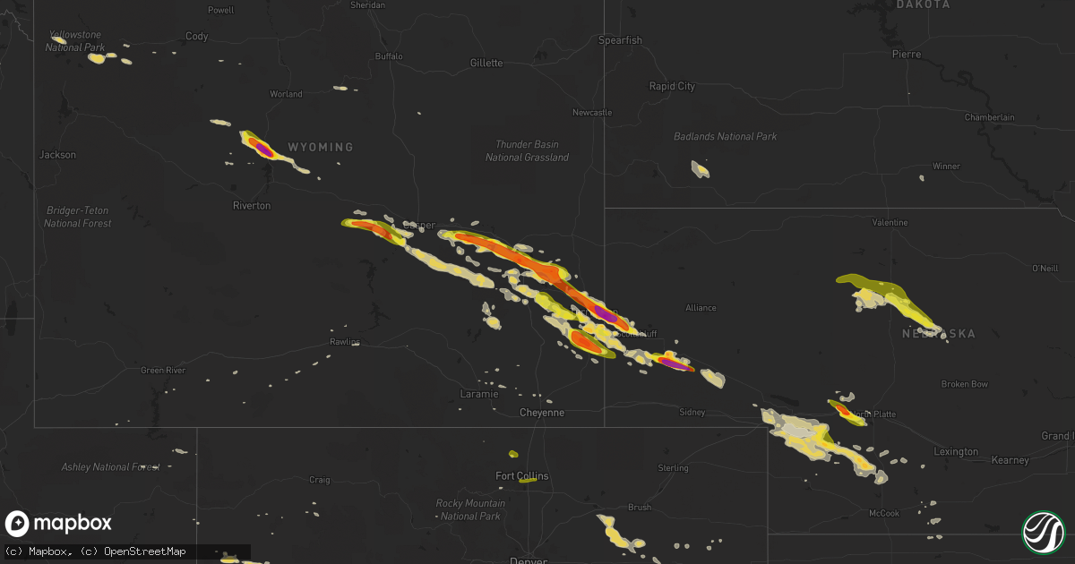
Hail Map on June 16, 2015
Get this storm
June 16 map
$229
one time, instant access
Download today. No call, no setup
Keep the $229
Bought the map and want the full workflow? Apply the entire $229 to a subscription within 7 days. None of it is wasted.
Every map, not just this one
This buys you this map. Subscription and you get every map we run, in the markets you choose from a few cities to whole states to nationwide. Plus real-time alerts the moment a storm fires.
Contact data
Name, contact info, occupancy, even credit band for addresses in the footprint. You go from where it hit to who to call.
Become the source they trust
Unlimited branding weather history reports on demand. You already have the documented answer ready for the property owner, and you are the one who showed up with it.
Property data and RoofTrace estimates
Pull up any address you have got, its value and the exact code rules for that jurisdiction, straight from One Click Code. Then RoofTrace estimates the squares, pitch, and roof value, priced the way you price.
States Impacted by Hail Map on June 16, 2015
Storm reports
Virginia
| Date | Description |
|---|---|
| 06/15/20159:40 PM CDT | Tree down near heritage park. |
| 06/15/20159:35 PM CDT | Tree down near hickory middle school |
Kentucky
| Date | Description |
|---|---|
| 06/16/20154:45 PM CDT | Multiple trees were blown down bringing powerlines down with them. |
| 06/16/20154:40 PM CDT | Trees were reported to have been blown down. |
| 06/16/20153:20 PM CDT | Trees were reported to have been blown down. Time of the event is estimated from radar. |
Wyoming
| Date | Description |
|---|---|
| 06/16/20156:59 PM CDT | A local report indicates 1.00 inch wind near 5 W GUERNSEY |
| 06/16/20156:53 PM CDT | A local report indicates 1.75 inch wind near TORRINGTON |
| 06/16/20156:48 PM CDT | Measured at airport. |
| 06/16/20156:17 PM CDT | Late report. |
| 06/16/20156:07 PM CDT | A local report indicates 1.75 inch wind near 5 N GUERNSEY |
| 06/16/20155:56 PM CDT | A local report indicates 1.75 inch wind near TORRINGTON |
| 06/16/20155:45 PM CDT | Late report. |
| 06/16/20155:30 PM CDT | A local report indicates 1.50 inch wind near 4 WNW U.S. HWY 220 MILE |
| 06/16/20155:30 PM CDT | Duration 10 minutes. |
| 06/16/20155:19 PM CDT | A local report indicates 1.75 inch wind near GLENDO |
| 06/16/20155:19 PM CDT | A local report indicates 1.25 inch wind near 3 N VETERAN |
| 06/16/20154:46 PM CDT | A local report indicates 1.00 inch wind near 13 SE GUERNSEY |
| 06/16/20154:22 PM CDT | Hail occurred near natural bridge. |
| 06/16/20154:03 PM CDT | Tornado was on the ground for 2 minutes. |
| 06/16/20153:25 PM CDT | Picture posted on facebook with damaged windshield |
| 06/16/20153:00 PM CDT | A local report indicates 1.00 inch wind near 5 S MISSOURI FLAT RD |
| 06/15/20158:06 PM CDT | Shredded leaves... Dented vehicles... Damaged shingles and broken car windows. |
| 06/15/20158:00 PM CDT | A local report indicates 1.50 inch wind near 3 S HAWK SPRINGS |
| 06/15/20157:59 PM CDT | A local report indicates 1.75 inch wind near 3 W HAWK SPRINGS |
New Mexico
| Date | Description |
|---|---|
| 06/16/20153:50 PM CDT | A local report indicates 1.25 inch wind near VERMEJO PARK |
Texas
| Date | Description |
|---|---|
| 06/16/20156:51 PM CDT | Automobile blown off the road near morales |
| 06/16/20156:50 PM CDT | Car port blown off |
| 06/16/20156:30 PM CDT | Wharton county sheriffs office has recieved numerous reports of trees down at many locations throughout the county. |
| 06/15/201510:00 PM CDT | Trees down in chappel hill |
| 06/15/20159:00 PM CDT | Trees down across the county fm 949 at swearingen rd and on mill creek rd |
Indiana
| Date | Description |
|---|---|
| 06/16/201512:15 AM CDT | Construction signs blown down at the intersection of highways 41 and 68. Time radar estimated...report received by gibson county sherrifs office at 1237 am cdt. |
| 06/15/201511:43 PM CDT | Report via social media photo included. |
Florida
| Date | Description |
|---|---|
| 06/16/20155:55 PM CDT | A green cherry tree fell on power lines in southern madison county during tuesdays storm causing a power outage. |
| 06/16/20154:55 PM CDT | Crystal river airport awos reported a 61 knot wind gust. |
| 06/16/20154:47 PM CDT | Cocorahs spotter reported dime to quarter sized hail and shredded leaves 4.7 miles ese of crystal river. |
| 06/16/20153:50 PM CDT | Tree limb downed. Time estimated. |
Montana
| Date | Description |
|---|---|
| 06/16/20155:15 PM CDT | Hail accumulations on ground nearing 1 inch. Spotter reported damage to property. |
Utah
| Date | Description |
|---|---|
| 06/16/20153:15 PM CDT | Large pine and aspen trees snapped near base of trees and smaller pine trees uprooted |
| 06/16/20153:10 PM CDT | A local report indicates a tornado near 12 SSW JARVIE RANCH |
Nebraska
| Date | Description |
|---|---|
| 06/16/20156:41 PM CDT | Relayed through media. |
| 06/16/20156:31 PM CDT | A local report indicates 1.00 inch wind near 4 ESE BROWNLEE |
| 06/16/20156:10 PM CDT | A local report indicates 1.00 inch wind near BROWNLEE |
| 06/16/20156:00 PM CDT | Hail accumulated 3 inches deep. Bark stripped off trees. Duration 30 minutes. |
| 06/16/20156:00 PM CDT | Duration 30 minutes. |
| 06/16/20156:00 PM CDT | Duration 45 minutes. Property damage. |
| 06/16/20155:56 PM CDT | A local report indicates 1.00 inch wind near LYMAN |
| 06/16/20154:36 PM CDT | A local report indicates 1.00 inch wind near 21 W BROWNLEE |
| 06/16/201510:15 AM CDT | Trees were blown down and pivot irrigators in the area were destroyed. |
| 06/15/201511:15 PM CDT | Widespread tree damage was also reported. |
| 06/15/201510:58 PM CDT | A local report indicates 1.00 inch wind near 4 N GRANT |
| 06/15/201510:15 PM CDT | Delayed report from tuesday... June 16th 2015 received via social media. Numerous empty pivots flipped over 4 to 5 miles southeast of big springs. Estimated winds in the (lbf |
| 06/15/201510:04 PM CDT | A local report indicates 66 MPH wind near 4 WSW BIG SPRINGS |
| 06/15/201510:00 PM CDT | A local report indicates 1.50 inch wind near 14 W MAYWOOD |
| 06/15/20159:40 PM CDT | A local report indicates 60 MPH wind near 11 SSE LISCO |
| 06/15/20159:34 PM CDT | A local report indicates 60 MPH wind near 11 SSE LISCO |
| 06/15/20159:30 PM CDT | A local report indicates 1.00 inch wind near 6 SSE DICKENS |
| 06/15/20159:10 PM CDT | 60-70 mph winds and one inch hail were reported. |
| 06/15/20159:04 PM CDT | A local report indicates 60 MPH wind near 3 S WALLACE |
| 06/15/20158:42 PM CDT | A local report indicates 1.00 inch wind near 7 SW NORTH PLATTE |
| 06/15/20158:35 PM CDT | A local report indicates 1.00 inch wind near GRAINTON |
| 06/15/20158:06 PM CDT | Three miles west of court house and jail rock. |
| 06/15/20158:03 PM CDT | Late report via social media. |
| 06/15/20158:02 PM CDT | A local report indicates 1.00 inch wind near 2 SE PURDUM |
| 06/15/20157:54 PM CDT | Public report relayed via talor warning point. Ground was covered with quarter size hail. Moderate rainfall. |
| 06/15/20157:45 PM CDT | Duration 20 minutes. |
| 06/15/20157:40 PM CDT | Brief rope tornado developed and dissipated |
| 06/15/20157:35 PM CDT | Duration 45 minutes. |
| 06/15/20157:35 PM CDT | A local report indicates 1.00 inch wind near 8 N ELSIE |
| 06/15/20157:33 PM CDT | A local report indicates 1.50 inch wind near 1 S MITCHELL |
| 06/15/20157:31 PM CDT | A local report indicates 1.00 inch wind near 1 W SUTHERLAND |
| 06/15/20157:30 PM CDT | Duration 30 minutes. |
| 06/15/20157:30 PM CDT | Hail accumulated 2 inches deep. Duration 30 minutes. |
| 06/15/20157:30 PM CDT | Duration 30 minutes. |
| 06/15/20157:25 PM CDT | Duration 10 minutes. |
| 06/15/20157:20 PM CDT | A local report indicates 1.00 inch wind near 24 NW THEDFORD |
| 06/15/20157:17 PM CDT | A local report indicates 1.75 inch wind near 2 N MORRILL |
| 06/15/20157:17 PM CDT | A local report indicates 1.00 inch wind near MORRILL |
| 06/15/20157:15 PM CDT | Duration 20 minutes. Broke windows. |
| 06/15/20157:15 PM CDT | Duration 35 minutes. |
| 06/15/20157:15 PM CDT | Hail accumulated 2 inches deep. Leaves were stripped from trees. Duration 20 minutes. |
| 06/15/20157:11 PM CDT | Tennis ball size hail. |
| 06/15/20157:00 PM CDT | Hail accumulated to 4 inches deep. Destroyed hay bales and corn crops. Duration 20 minutes. |
| 06/15/20157:00 PM CDT | A local report indicates 1.75 inch wind near 2 NE SUTHERLAND |
| 06/15/20157:00 PM CDT | Duration 30 minutes. |
Colorado
| Date | Description |
|---|---|
| 06/16/20156:43 PM CDT | A local report indicates 60 MPH wind near 1 NW FORT MORGAN |
| 06/16/20154:05 PM CDT | A local report indicates 1.00 inch wind near 6 ESE FORT COLLINS |
| 06/16/20153:57 PM CDT | A local report indicates 1.00 inch wind near 4 S FORT COLLINS |
| 06/16/20159:04 AM CDT | A local report indicates 1.15 inch wind near 2 ESE MIDWAY |
| 06/15/20158:00 PM CDT | A local report indicates 60 MPH wind near 5 E NEW CASTLE |
| 06/15/20157:30 PM CDT | A local report indicates 58 MPH wind near 2 NE WIGGINS |
Illinois
| Date | Description |
|---|---|
| 06/16/20151:00 AM CDT | Some tree damage with limbs - greater than 2 inch diameter - down. Corn fields have quite a bit of damage with several fields having crops flattened or leaning. Estimat |
| 06/16/201512:40 AM CDT | Couple trees down in town along with power lines snapped |
Arizona
| Date | Description |
|---|---|
| 06/15/20158:25 PM CDT | Kdug asos recorded a wind gust of 50 knots from the ene at 0125 utc. |
New Jersey
| Date | Description |
|---|---|
| 06/16/20152:34 PM CDT | Wires down in the township |
| 06/16/20152:29 PM CDT | Trees down in estell manor and ventor. |
Georgia
| Date | Description |
|---|---|
| 06/16/20154:54 PM CDT | Several large trees down in bethany hills neighborhood off valdel rd. |
South Carolina
| Date | Description |
|---|---|
| 06/16/20156:27 PM CDT | A cluster of at least 6 to 8 trees were blown down very close to the south carolina state line near the intersection of hunting country road and red barn road. |
Cities Impacted by Hail Map on June 16, 2015
- Dickens, NE
- Ogallala, NE
- Big Timber, MT
- Torrington, WY
- Glendo, WY
- Hartville, WY
- Jay Em, WY
- Thedford, NE
- Halsey, NE
- Johnstown, NE
- Purdum, NE
- Valentine, NE
- Aguilar, CO
- Wiggins, CO
- Fort Morgan, CO
- Byers, CO
- Thermopolis, WY
- Rapelje, MT
- Ryegate, MT
- Molt, MT
- North Platte, NE
- Wheatland, WY
- Hawk Springs, WY
- Yoder, WY
- Venango, NE
- Brule, NE
- Cleveland, NM
- Mora, NM
- Guernsey, WY
- Deer Trail, CO
- Agate, CO
- Charleston, MO
- Parachute, CO
- Billings, MT
- Laurel, MT
- Fort Smith, MT
- Saint Xavier, MT
- Lodge Grass, MT
- Cody, WY
- Two Dot, MT
- Glenrock, WY
- Douglas, WY
- Limon, CO
- Lyman, NE
- Morrill, NE
- Grant, NE
- Lysite, WY
- Bridgeport, NE
- Harrisburg, NE
- Bayard, NE
- Park City, MT
- Magdalena, NM
- Lagrange, WY
- Veteran, WY
- Kit Carson, CO
- Hugo, CO
- Flagler, CO
- Sutherland, NE
- Hershey, NE
- Casper, WY
- Woodrow, CO
- Madrid, NE
- Chickamauga, GA
- Gallina, NM
- Ten Sleep, WY
- Garrett, WY
- Bosler, WY
- Riverton, WY
- Shoshoni, WY
- Big Springs, NE
- Holbrook, NE
- Norton, KS
- Hayes Center, NE
- Pavillion, WY
- Greenville, KY
- Elkton, KY
- Evansville, IN
- Elsie, NE
- Hardinsburg, KY
- Rawlins, WY
- Wallace, NE
- Rangely, CO
- Scottsbluff, NE
- Mitchell, NE
- Lingle, WY
- Lindon, CO
- Dunnellon, FL
- Pine Ridge, SD
- Homosassa, FL
- Falls Of Rough, KY
- Olaton, KY
- McCook, NE
- Maywood, NE
- Winner, SD
- Paxton, NE
- Weston, CO
- Tampa, FL
- Gibsonton, FL
- Lodgepole, NE
- Broadwater, NE
- Raton, NM
- Alford, FL
- Mount Vernon, IN
- Westville, FL
- Caryville, FL
- Ponderosa, NM
- Dalton, NE
- Lisco, NE
- Belton, KY
- Lecanto, FL
- Wadesville, IN
- Poseyville, IN
- Gering, NE
- Wellfleet, NE
- San Cristobal, NM
- Arroyo Hondo, NM
- Shawnee, WY
- Yuma, CO
- Buckhorn, NM
- Meeker, CO
- Crystal River, FL
- Akron, CO
- Cimarron, NM
- Inverness, FL
- Princeton, KY
- Whitehall, MT
- Rifle, CO
- Shawmut, MT
- Melville, MT
- Fort Laramie, WY
- Cheyenne Wells, CO
- Cheyenne, WY
- Monticello, KY
- Datil, NM
- Waverly, KY
- Uniontown, KY
- Corydon, KY
- Henderson, KY
- Elbert, CO
- Kiowa, CO
- Laramie, WY
- Trinidad, CO
- Parkman, WY
- De Beque, CO
- Curtis, NE
- Cadiz, KY
- Laporte, CO
- Bellvue, CO
- Franktown, CO
- Silt, CO
- Moorefield, NE
- Chacon, NM
- Eustis, NE
- South Fulton, TN
- Wimauma, FL
- Sun City Center, FL
- Wyola, MT
- Ramah, CO
- Fordsville, KY
- Kaycee, WY
- Hopkinsville, KY
- Wilsonville, NE
- East Dublin, GA
- Carson, NM
- Thoreau, NM
- Valdosta, GA
- Hahira, GA
- Freeburg, MO
- Crownpoint, NM
- Festus, MO
- Valdez, NM
- El Prado, NM
- Atmore, AL
- Beaver City, NE
- Hendley, NE
- Cerulean, KY
- Dawson Springs, KY
- Drake, CO
- Loveland, CO
- Beverly Hills, FL
- Minatare, NE
- Hernando, FL
- Caneyville, KY
- Dunning, NE
- Colorado Springs, CO
- Dayton, WY
- Riverview, FL
- Apollo Beach, FL
- Imperial, NE
- Crofton, KY
- Mills, WY
- Fountain, FL
- Wellington, CO
- Fort Collins, CO
- Timnath, CO
- Windsor, CO
- Broadview, MT