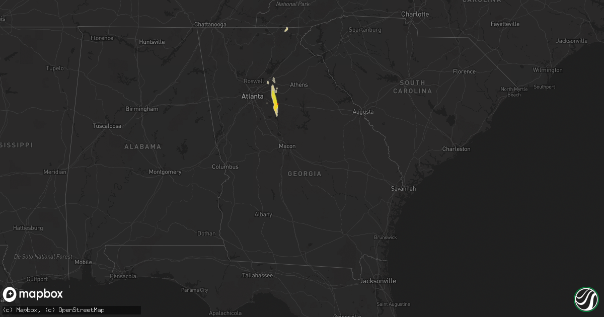
Hail Map in Georgia on June 15, 2020
Get this storm
June 15 map
$229
one time, instant access
Download today. No call, no setup
Keep the $229
Bought the map and want the full workflow? Apply the entire $229 to a subscription within 7 days. None of it is wasted.
Every map, not just this one
This buys you this map. Subscription and you get every map we run, in the markets you choose from a few cities to whole states to nationwide. Plus real-time alerts the moment a storm fires.
Contact data
Name, contact info, occupancy, even credit band for addresses in the footprint. You go from where it hit to who to call.
Become the source they trust
Unlimited branding weather history reports on demand. You already have the documented answer ready for the property owner, and you are the one who showed up with it.
Property data and RoofTrace estimates
Pull up any address you have got, its value and the exact code rules for that jurisdiction, straight from One Click Code. Then RoofTrace estimates the squares, pitch, and roof value, priced the way you price.
Storm reports in Georgia
Georgia
| Date | Description |
|---|---|
| 06/15/20204:10 PM CDT | Power lines downed at 1 johnson river rd and east end rd |
| 06/15/20204:05 PM CDT | Tree was downed and blocked the road at king bostick rd and moores rd |
| 06/15/20204:00 PM CDT | Power lines downed at johnson river rd and east end rd |
| 06/15/20203:49 PM CDT | Hail ranging from nickel to golf ball size was reported at the intersection of hwy 278 and dr. Martin luther king jr ave. Vehicle sustained damage from the largest hail |
| 06/15/20203:47 PM CDT | Trained spotter reported quarter-sized hail at the intersection of hwy 278 and pace st. |
| 06/15/20203:47 PM CDT | Hail ranging from nickel to golf ball size was reported at the intersection of hwy 278 and dr. Martin luther king jr ave. Vehicle sustained damage from the largest hail |
| 06/15/20203:33 PM CDT | Area of trees uprooted and power poles downed in the walnut grove area... Especially along cannon farm rd. Photos of damage suggest winds up to around 75 mph. |
| 06/15/20203:30 PM CDT | A large oak tree and a pine tree were reported down on hickory hill dr near the intersection with mt. Zion rd. |
| 06/15/20203:20 PM CDT | Picture submitted on social media shows several trees down and powerlines snapped along center hill church road between ga hwy 20 and rabbit farm road. |
| 06/15/20203:10 PM CDT | Multiple trees down along hoke okelly mill road. |
| 06/15/20203:05 PM CDT | Powerlines down along the 600 block of grayson new hope road. |
| 06/15/20203:05 PM CDT | Tree down in 2000 block of leafmore ct. Se. |
| 06/15/20202:37 PM CDT | Trained spotter reported quarter-sized hail at the intersection of hwy 278 and pace st. |
| 06/14/202011:58 PM CDT | At 457 PM EDT, a severe thunderstorm was located over Starrsville, or near Covington, moving south at 35 mph. HAZARD...60 mph wind gusts and quarter size hail. SOURCE...Radar indicated. IMPACT...Hail damage to vehicles is expected. Expect wind damage to roofs, siding, and trees. Locations impacted include... Covington, Porterdale, Mansfield, Stewart, Calvin, Eudora, Turtle Cove, Worthville, North Alcovy, Starrsville and Rocky Plains. |
| 06/14/202011:22 PM CDT | At 422 PM EDT, a severe thunderstorm was located over Big Haynes Creek Park, or 8 miles northeast of Conyers, moving south at 25 mph. HAZARD...60 mph wind gusts and quarter size hail. SOURCE...Radar indicated. IMPACT...Hail damage to vehicles is expected. Expect wind damage to roofs, siding, and trees. Locations impacted include... Conyers, Covington, Loganville, Social Circle, Oxford, Porterdale, Walnut Grove, Between, Jersey, Georgia International Horse Park, Almon, Milstead, Youth, Big Haynes Creek Park, Brick Store and Gum Creek. |
| 06/14/202011:02 PM CDT | At 401 PM EDT, a severe thunderstorm was located over Harbin, or near Lawrenceville, moving southeast at 25 mph. HAZARD...60 mph wind gusts and quarter size hail. SOURCE...Radar indicated. IMPACT...Hail damage to vehicles is expected. Expect wind damage to roofs, siding, and trees. Locations impacted include... Lawrenceville, Monroe, Snellville, Loganville, Dacula, Grayson, Walnut Grove, Between, Good Hope, Jersey, Bold Springs, Windsor, Harbin, Nicholasville, Youth, Pannell, Rosebud, Campton and Herndonville. |


