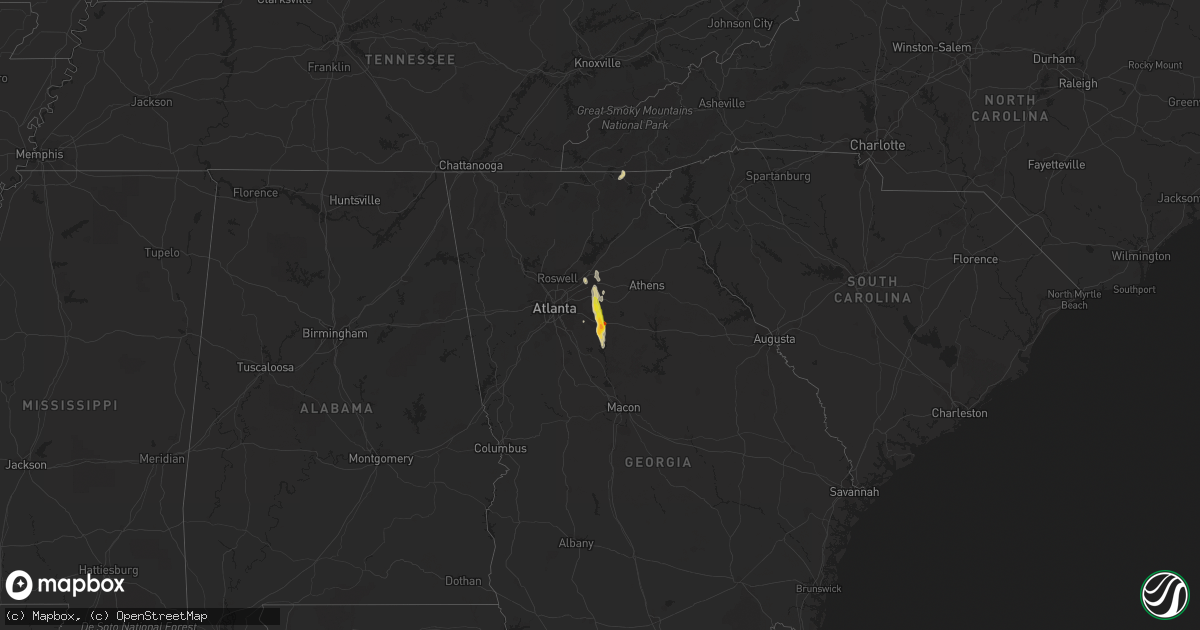
Hail Map on June 15, 2020
Get this storm
June 15 map
$229
one time, instant access
Download today. No call, no setup
Keep the $229
Bought the map and want the full workflow? Apply the entire $229 to a subscription within 7 days. None of it is wasted.
Every map, not just this one
This buys you this map. Subscription and you get every map we run, in the markets you choose from a few cities to whole states to nationwide. Plus real-time alerts the moment a storm fires.
Contact data
Name, contact info, occupancy, even credit band for addresses in the footprint. You go from where it hit to who to call.
Become the source they trust
Unlimited branding weather history reports on demand. You already have the documented answer ready for the property owner, and you are the one who showed up with it.
Property data and RoofTrace estimates
Pull up any address you have got, its value and the exact code rules for that jurisdiction, straight from One Click Code. Then RoofTrace estimates the squares, pitch, and roof value, priced the way you price.
States Impacted by Hail Map on June 15, 2020
Storm reports
Tennessee
| Date | Description |
|---|---|
| 06/15/20201:00 PM CDT | A local report indicates 1.00 inch wind near 2 N SEYMOUR |
| 06/14/20208:25 PM CDT | At 124 PM EDT, a severe thunderstorm was located over Pigeon Forge, or near Sevierville, moving northwest at 5 mph. HAZARD...60 mph wind gusts and quarter size hail. SOURCE...Radar indicated. IMPACT...Hail damage to vehicles is expected. Expect wind damage to roofs, siding, and trees. Locations impacted include... Sevierville, Pigeon Forge, McMahan, Harrisburg, Seymour and Kodak. This includes Interstate 40 in Tennessee between mile markers 406 and409. |
Georgia
| Date | Description |
|---|---|
| 06/15/20204:10 PM CDT | Power lines downed at 1 johnson river rd and east end rd |
| 06/15/20204:05 PM CDT | Tree was downed and blocked the road at king bostick rd and moores rd |
| 06/15/20204:00 PM CDT | Power lines downed at johnson river rd and east end rd |
| 06/15/20203:49 PM CDT | Hail ranging from nickel to golf ball size was reported at the intersection of hwy 278 and dr. Martin luther king jr ave. Vehicle sustained damage from the largest hail |
| 06/15/20203:47 PM CDT | Trained spotter reported quarter-sized hail at the intersection of hwy 278 and pace st. |
| 06/15/20203:47 PM CDT | Hail ranging from nickel to golf ball size was reported at the intersection of hwy 278 and dr. Martin luther king jr ave. Vehicle sustained damage from the largest hail |
| 06/15/20203:33 PM CDT | Area of trees uprooted and power poles downed in the walnut grove area... Especially along cannon farm rd. Photos of damage suggest winds up to around 75 mph. |
| 06/15/20203:30 PM CDT | A large oak tree and a pine tree were reported down on hickory hill dr near the intersection with mt. Zion rd. |
| 06/15/20203:20 PM CDT | Picture submitted on social media shows several trees down and powerlines snapped along center hill church road between ga hwy 20 and rabbit farm road. |
| 06/15/20203:10 PM CDT | Multiple trees down along hoke okelly mill road. |
| 06/15/20203:05 PM CDT | Powerlines down along the 600 block of grayson new hope road. |
| 06/15/20203:05 PM CDT | Tree down in 2000 block of leafmore ct. Se. |
| 06/15/20202:37 PM CDT | Trained spotter reported quarter-sized hail at the intersection of hwy 278 and pace st. |
| 06/14/202011:58 PM CDT | At 457 PM EDT, a severe thunderstorm was located over Starrsville, or near Covington, moving south at 35 mph. HAZARD...60 mph wind gusts and quarter size hail. SOURCE...Radar indicated. IMPACT...Hail damage to vehicles is expected. Expect wind damage to roofs, siding, and trees. Locations impacted include... Covington, Porterdale, Mansfield, Stewart, Calvin, Eudora, Turtle Cove, Worthville, North Alcovy, Starrsville and Rocky Plains. |
| 06/14/202011:22 PM CDT | At 422 PM EDT, a severe thunderstorm was located over Big Haynes Creek Park, or 8 miles northeast of Conyers, moving south at 25 mph. HAZARD...60 mph wind gusts and quarter size hail. SOURCE...Radar indicated. IMPACT...Hail damage to vehicles is expected. Expect wind damage to roofs, siding, and trees. Locations impacted include... Conyers, Covington, Loganville, Social Circle, Oxford, Porterdale, Walnut Grove, Between, Jersey, Georgia International Horse Park, Almon, Milstead, Youth, Big Haynes Creek Park, Brick Store and Gum Creek. |
| 06/14/202011:02 PM CDT | At 401 PM EDT, a severe thunderstorm was located over Harbin, or near Lawrenceville, moving southeast at 25 mph. HAZARD...60 mph wind gusts and quarter size hail. SOURCE...Radar indicated. IMPACT...Hail damage to vehicles is expected. Expect wind damage to roofs, siding, and trees. Locations impacted include... Lawrenceville, Monroe, Snellville, Loganville, Dacula, Grayson, Walnut Grove, Between, Good Hope, Jersey, Bold Springs, Windsor, Harbin, Nicholasville, Youth, Pannell, Rosebud, Campton and Herndonville. |
North Dakota
| Date | Description |
|---|---|
| 06/15/20207:33 AM CDT | At 1233 AM CDT, severe thunderstorms were located along a line extending from 6 miles southeast of Belden to 7 miles west of Ross, moving northeast at 35 mph. HAZARD...60 mph wind gusts and quarter size hail. SOURCE...Radar indicated. IMPACT...Hail damage to vehicles is expected. Expect wind damage to roofs, siding, and trees. Severe thunderstorms will be near... Stanley around 1250 AM CDT. Palermo and Lostwood around 100 AM CDT. Blaisdell around 105 AM CDT.Other locations impacted by these severe thunderstorms includeCoulee, Tagus and White Earth. |
| 06/14/20209:24 PM CDT | At 224 AM CDT, severe thunderstorms were located along a line extending from 10 miles northeast of Bowbells to 12 miles northeast of Kenmare to 6 miles south of Greene, moving northeast at 45 mph. HAZARD...60 mph wind gusts and quarter size hail. SOURCE...Radar indicated. IMPACT...Hail damage to vehicles is expected. Expect wind damage to roofs, siding, and trees. Severe thunderstorms will be near... Mohall around 245 AM CDT. Sherwood around 250 AM CDT. Antler around 310 AM CDT.Other locations impacted by these severe thunderstorms includeLoraine, Tolley, Grano and Norma. |
| 06/14/20208:53 PM CDT | At 153 AM CDT, a severe thunderstorm was located 10 miles south of Kenmare, or 17 miles northeast of Stanley, moving northeast at 45 mph. HAZARD...60 mph wind gusts and quarter size hail. SOURCE...Radar indicated. IMPACT...Hail damage to vehicles is expected. Expect wind damage to roofs, siding, and trees. This severe thunderstorm will be near... Kenmare around 205 AM CDT.Other locations impacted by this severe thunderstorm include Tolley,Norma, Niobe and Coulee. |
| 06/14/20208:48 PM CDT | At 148 AM CDT, a severe thunderstorm was located 8 miles north of Greene, or 10 miles west of Mohall, moving northeast at 40 mph. HAZARD...60 mph wind gusts and quarter size hail. SOURCE...Radar indicated. IMPACT...Hail damage to vehicles is expected. Expect wind damage to roofs, siding, and trees. This severe thunderstorm will be near... Sherwood around 210 AM CDT.Other locations impacted by this severe thunderstorm include Loraineand Tolley. |
| 06/14/20208:42 PM CDT | At 141 AM CDT, a severe thunderstorm was located near Battleview, or 22 miles northwest of Stanley, moving northeast at 40 mph. A wind gust of 59 mph was reported at Tioga. HAZARD...60 mph wind gusts and nickel size hail. SOURCE...Radar indicated. IMPACT...Expect damage to roofs, siding, and trees. This severe thunderstorm will be near... Powers Lake around 145 AM CDT. Lignite around 215 AM CDT.Other locations impacted by this severe thunderstorm include Coteau. |
| 06/14/20208:13 PM CDT | At 113 AM CDT, a severe thunderstorm was located 6 miles southwest of Donnybrook, or 20 miles northeast of Stanley, moving northeast at 35 mph. HAZARD...60 mph wind gusts and quarter size hail. SOURCE...Radar indicated. IMPACT...Hail damage to vehicles is expected. Expect wind damage to roofs, siding, and trees. This severe thunderstorm will be near... Donnybrook around 125 AM CDT. Greene around 145 AM CDT.Other locations impacted by this severe thunderstorm include Coulee,Tolley and Grano. |
Arizona
| Date | Description |
|---|---|
| 06/14/20209:36 PM CDT | At 236 PM MST, a severe thunderstorm was located 7 miles south of Tombstone, or 12 miles northeast of Sierra Vista, moving northeast at 10 mph. HAZARD...60 mph wind gusts. SOURCE...Radar indicated. IMPACT...Expect damage to roofs, siding, and trees. Locations impacted include... Sierra Vista, Tombstone and Charleston. This includes the following highways... Route 80 between mile markers 316 and 332. Route 90 between mile markers 323 and 335. |
| 06/14/20209:04 PM CDT | At 204 PM MST, a severe thunderstorm was located over Benson, moving northeast at 10 mph. HAZARD...60 mph wind gusts. SOURCE...Radar indicated. IMPACT...Expect damage to roofs, siding, and trees. Locations impacted include... Benson, St. David and Kartchner Caverns State Park. This includes the following highways... Interstate 10 between mile markers 299 and 313. Route 80 between mile markers 293 and 303. Route 90 between mile markers 290 and 301. |
| 06/14/20208:50 PM CDT | At 150 PM MST, a severe thunderstorm was located near Bisbee, moving northeast at 10 mph. HAZARD...60 mph wind gusts. SOURCE...Radar indicated. IMPACT...Expect damage to roofs, siding, and trees. Locations impacted include... Bisbee and Naco. This includes the following highways... Route 80 between mile markers 338 and 355. Route 92 between mile markers 348 and 355. Route 191 between mile markers 11 and 15. |