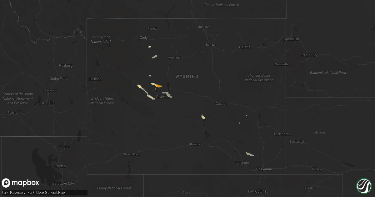
Hail Map in Wyoming on June 15, 2019
Get this storm
June 15 map
$229
one time, instant access
Download today. No call, no setup
Keep the $229
Bought the map and want the full workflow? Apply the entire $229 to a subscription within 7 days. None of it is wasted.
Every map, not just this one
This buys you this map. Subscription and you get every map we run, in the markets you choose from a few cities to whole states to nationwide. Plus real-time alerts the moment a storm fires.
Contact data
Name, contact info, occupancy, even credit band for addresses in the footprint. You go from where it hit to who to call.
Become the source they trust
Unlimited branding weather history reports on demand. You already have the documented answer ready for the property owner, and you are the one who showed up with it.
Property data and RoofTrace estimates
Pull up any address you have got, its value and the exact code rules for that jurisdiction, straight from One Click Code. Then RoofTrace estimates the squares, pitch, and roof value, priced the way you price.
Storm reports in Wyoming
Wyoming
| Date | Description |
|---|---|
| 06/15/20194:57 PM CDT | Almost covered the ground |
| 06/14/201910:16 PM CDT | At 316 PM MDT, a severe thunderstorm was located 8 miles north of Pavillion, moving east at 20 mph. HAZARD...Quarter size hail. SOURCE...Radar indicated. IMPACT...Damage to vehicles is expected. This severe thunderstorm will remain over mainly rural areas of northeastern Fremont County. |
All States Impacted by Hail Map on June 15, 2019
Cities Impacted by Hail Map on June 15, 2019
- La Plata, MO
- Orrick, MO
- Excelsior Springs, MO
- Richmond, MO
- Rayville, MO
- Cunningham, KS
- Liberal, MO
- Lamar, MO
- Oronogo, MO
- Overbrook, OK
- Burneyville, OK
- Hereford, TX
- Monroe, IA
- Prairie City, IA
- Conde, SD
- Buffalo, OK
- Justiceburg, TX
- Olton, TX
- Kinderhook, IL
- Saint Paul, KS
- Altamont, KS
- Parsons, KS
- Franklinton, LA
- Lockney, TX
- Floydada, TX
- Morning Sun, IA
- Winfield, IA
- Follett, TX
- Wichita Falls, TX
- Henrietta, TX
- Eldorado, TX
- Newton, KS
- Fredonia, KS
- Matador, TX
- Flomot, TX
- Granada, MN
- Paducah, TX
- Hardin, MO
- Sandoval, IL
- Moundville, MO
- Cedar Vale, KS
- Meeteetse, WY
- Garwin, IA
- Marshalltown, IA
- Le Grand, IA
- Montour, IA
- Erick, OK
- Texola, OK
- Wayside, TX
- Amorita, OK
- Manchester, OK
- Peabody, KS
- Florence, KS
- Forsyth, MO
- Tulia, TX
- Okabena, MN
- Brewster, MN
- Heron Lake, MN
- Wilmore, KS
- Breda, IA
- Carroll, IA
- Dugger, IN
- Merom, IN
- Switz City, IN
- Worthington, IN
- Jasonville, IN
- Hutsonville, IL
- Carlisle, IN
- Sullivan, IN
- Linton, IN
- Robinson, IL
- Palestine, IL
- Manson, IA
- Reasnor, IA
- Otley, IA
- Pella, IA
- Fort Stockton, TX
- Sheffield, TX
- Ozona, TX
- Dryden, TX
- Longton, KS
- Perry, IA
- Rocksprings, TX
- Sonora, TX
- Norwich, KS
- Borger, TX
- Skellytown, TX
- Panhandle, TX
- Lovilia, IA
- Shidler, OK
- Claude, TX
- Washington, KS
- Hanover, KS
- Barnes, KS
- Joice, IA
- Lake Mills, IA
- Mahaska, KS
- Viola, KS
- Piedmont, KS
- Beaumont, KS
- Leon, KS
- Pocahontas, IA
- Palmer, IA
- Pomeroy, IA
- Fargo, OK
- Argonia, KS
- Marietta, OK
- Ostrander, MN
- Spring Valley, MN
- Grand Meadow, MN
- Walnut, KS
- Girard, KS
- Stockton, MO
- Petrolia, TX
- Panora, IA
- Yale, IA
- Gilson, IL
- Cameron, IL
- London Mills, IL
- Maquon, IL
- Knoxville, IL
- Abingdon, IL
- Monmouth, IL
- Saint Augustine, IL
- Galesburg, IL
- Berwick, IL
- Carmen, OK
- Dacoma, OK
- Aline, OK
- Shattuck, OK
- Latham, KS
- Pavillion, WY
- Riverton, WY
- Eureka, KS
- Electra, TX
- Iowa Park, TX
- Ogden, IA
- Taloga, OK
- Worland, WY
- Joplin, MO
- Carthage, MO
- Olney, TX
- Del Rio, TX
- Woodward, OK
- Emporia, KS
- Strong City, KS
- Cottonwood Falls, KS
- Medicine Lodge, KS
- Rose Hill, IA
- What Cheer, IA
- New Sharon, IA
- Harrold, TX
- Remsen, IA
- Le Mars, IA
- Conrad, IA
- Alden, IA
- Iowa Falls, IA
- Eldora, IA
- Whitten, IA
- Union, IA
- Dalhart, TX
- McCune, KS
- Colwich, KS
- Mount Hope, KS
- Independence, KS
- Burden, KS
- Truman, MN
- Saint James, MN
- Rolfe, IA
- Dumas, TX
- Bussey, IA
- Albia, IA
- Hamilton, IA
- Eddyville, IA
- Oskaloosa, IA
- Omega, OK
- Watonga, OK
- Kingfisher, OK
- Burkburnett, TX
- Dimmitt, TX
- Friona, TX
- Summerfield, TX
- Muleshoe, TX
- Nemaha, NE
- Hollenberg, KS
- Cherryvale, KS
- Gladbrook, IA
- Toledo, IA
- Granite City, IL
- Maryville, IL
- Troy, IL
- Collinsville, IL
- Glen Carbon, IL
- Newcastle, TX
- Plainview, TX
- Putnam, OK
- Custer City, OK
- Overbrook, KS
- Berryton, KS
- Lecompton, KS
- Flat Rock, IL
- Mooreland, OK
- Rochester, TX
- O'Brien, TX
- Rippey, IA
- Sigourney, IA
- Hedrick, IA
- Fremont, IA
- West Terre Haute, IN
- Paris, IL
- Cambridge, KS
- Grenola, KS
- Dawson, IA
- Oak Grove, MO
- Napoleon, MO
- Martinsville, MO
- Denver, MO
- Greentop, MO
- Kirksville, MO
- Novinger, MO
- Crocker, MO
- Wichita, KS
- Goddard, KS
- Gridley, KS
- Newburg, MO
- Rolla, MO
- Ponca City, OK
- Newkirk, OK
- White Deer, TX
- Andale, KS
- Mount Union, IA
- Olds, IA
- Mount Pleasant, IA
- Jefferson, IA
- Jamaica, IA
- Hannibal, MO
- Haven, KS
- Cleo Springs, OK
- Waynoka, OK
- Fairview, OK
- West Liberty, IL
- Sainte Marie, IL
- Newton, IL
- Willow Hill, IL
- Old Glory, TX
- Rule, TX
- Aspermont, TX
- Laurens, IA
- Havelock, IA
- Mapleton, IL
- Glasford, IL
- Canton, IL
- Shumway, IL
- Cowden, IL
- Beecher City, IL
- Columbus, KS
- Isabella, OK
- Okeene, OK
- Burlington, OK
- Keota, IA
- Mitchellville, IA
- Runnells, IA
- Lake City, KS
- Sawyer, KS
- Sun City, KS
- Geary, OK
- Mountain View, OK
- Cordell, OK
- Carnegie, OK
- Marion, KS
- Alcova, WY
- Kansas City, MO
- Independence, MO
- Seiling, OK
- Kingman, KS
- Chetopa, KS
- Steamboat Rock, IA
- Chester, OK
- Oakville, IA
- Kidder, MO
- Hamilton, MO
- Moline, KS
- Elk Falls, KS
- Erie, KS
- Thayer, KS
- Chanute, KS
- Galesburg, KS
- Elmer, OK
- Happy, TX
- Channing, TX
- Wells, MN
- Kiester, MN
- Promise City, IA
- Texhoma, OK
- Smithboro, IL
- Vernon, IL
- Keyesport, IL
- Patoka, IL
- Shobonier, IL
- Pocahontas, IL
- Carlyle, IL
- Greenville, IL
- Breese, IL
- Mulberry Grove, IL
- Vandalia, IL
- Adrian, MO
- Lebanon, MO
- Eldridge, MO
- Atlanta, KS
- Ash Grove, MO
- Everton, MO
- Odell, TX
- Chillicothe, TX
- Vernon, TX
- Holliday, TX
- Grain Valley, MO
- Bates City, MO
- Buckner, MO
- Sunray, TX
- Waldron, KS
- Hazelton, KS
- Willow, OK
- Monroe City, MO
- Hunnewell, MO
- Junction, TX
- Isabel, KS
- Crosbyton, TX
- Vassar, KS
- Lyndon, KS
- Garrett, WY
- Boone, IA
- Jasper, MO
- Castor, LA
- Walker, LA
- Pine Grove, LA
- Holden, LA
- Wayland, IA
- El Dorado, AR
- Junction City, AR
- Chesterfield, MO
- Wildwood, MO
- Winnebago, MN
- Bolivar, MO
- Edna, KS
- Stratford, SD
- Springlake, TX
- Arcadia, LA
- Clifton Hill, MO
- Turkey, TX
- Lander, WY
- Arapahoe, WY
- Fort Washakie, WY
- Frederick, SD
- Pollock, MO
- Milan, MO
- Arcola, MO
- Neodesha, KS
- Canton, OK
- Crowell, TX
- Shamrock, TX
- Wellington, TX
- Earth, TX
- Dana, IA
- Victor, IA
- Ladora, IA
- Summerfield, LA
- Richland, MO
- Norborne, MO
- Dover, MO
- Winfield, KS
- Alva, OK
- Sumner, MO
- Hartford, KS
- Burlington, KS
- Lakefield, MN
- Hennessey, OK
- Lorenzo, TX
- Clinton, OK
- Clare, IA
- Gilmore City, IA
- Barnum, IA
- Ringgold, TX
- Hart, TX
- Hale Center, TX
- La Veta, CO
- Okarche, OK
- Iraan, TX
- Axtell, KS
- Miller, MO
- Lockwood, MO
- Winchester, IL
- Litchfield, IL
- Butler, MO
- Cheney, KS
- Pretty Prairie, KS
- Gallatin, MO
- Bern, KS
- Dawson, NE
- Pawnee City, NE
- Humboldt, NE
- Du Bois, NE
- Effingham, IL
- Sigel, IL
- Rock, KS
- Seymour, TX
- Dickens, TX
- Knox City, TX
- Montezuma, IA
- Pomona, KS
- Melvern, KS
- Quenemo, KS
- Weinert, TX
- West Des Moines, IA
- Cumming, IA
- Rotan, TX
- Cedar Point, KS
- Waynesville, MO
- Des Moines, IA
- Norwalk, IA
- Medford, OK
- Throckmorton, TX
- Goree, TX
- Munday, TX
- Ralls, TX
- Mound City, MO
- Craig, MO
- Maitland, MO
- Ollie, IA
- Corwith, IA
- Marcus, IA
- Edina, MO
- Novelty, MO
- Nashville, KS
- Harrah, OK
- Kanawha, IA
- Sheldon, MO
- El Dorado Springs, MO
- Thomas, OK
- Arapaho, OK
- Butler, OK
- Weatherford, OK
- Oakwood, OK
- Leedey, OK
- Galva, IA
- Douglass, KS
- Yale, OK
- Sudan, TX
- Luther, OK
- Lawton, OK
- Cherokee, IA
- Virgil, KS
- Webb City, MO
- Pierce City, MO
- Granby, MO
- Taopi, MN
- Adams, MN
- Cherokee, OK
- Sayre, OK
- Sweetwater, OK
- Le Roy, MN
- Chester, IA
- Wellington, KS
- Leon, OK
- Edmond, OK
- Bricelyn, MN
- Sully, IA
- Newton, IA
- Bevier, MO
- Macon, MO
- Childress, TX
- Frederick, OK
- Greensburg, LA
- Newell, IA
- Kulm, ND
- Conroe, TX
- Galt, MO
- Laredo, MO
- Humphreys, MO
- Trenton, MO
- Jamesport, MO
- Fairview Heights, IL
- Caseyville, IL
- Sugar City, CO
- Sarcoxie, MO
- Wentworth, MO
- Wheeler, TX
- Adrian, TX
- Roxana, IL
- Wood River, IL
- Edwardsville, IL
- South Roxana, IL
- Moore Haven, FL
- Shelbyville, MO
- Saint James, MO
- Cook Sta, MO
- Black, MO
- Hydro, OK
- Memphis, TX
- Lakeview, TX
- Madill, OK
- Schaller, IA
- Rantoul, IL
- Thomasboro, IL
- Pawhuska, OK
- Ozark, MO
- Nixa, MO
- Dundas, IL
- Olney, IL
- Falls City, NE
- Salem, IL
- Claremont, IL
- Hartley, TX
- Douglas, WY
- Buffalo, MO
- Louisburg, MO
- Crowheart, WY
- Waukee, IA
- Elk City, KS
- Absarokee, MT
- Amboy, MN
- Fall River, KS
- Altoona, KS
- Asbury, MO
- Atoka, OK
- Lane, OK
- Murdock, KS
- Searsboro, IA
- Philadelphia, MO
- Albert Lea, MN
- Alden, MN
- Breckenridge, MO
- Kansas City, KS
- Clark, MO
- Harcourt, IA
- Austin, MN
- Brownsdale, MN
- Sharon, OK
- Springer, NM
- Guthrie, OK
- Bloomington, IL
- Downs, IL
- Clarence, MO
- Raton, NM
- Highland, IL
- Waverly, KS
- Green Castle, MO
- Green City, MO
- Sweet Springs, MO
- Concordia, MO
- Anthony, KS
- Sedgwick, KS
- Memphis, MO
- Callao, MO
- Kasson, MN
- Hayfield, MN
- Dodge Center, MN
- Kress, TX
- Perrin, TX
- Jacksboro, TX
- Gerlaw, IL
- Yates City, IL
- Emden, MO
- Afton, TX
- Mcadoo, TX
- Roaring Springs, TX
- Hammon, OK
- Seaton, IL
- Neosho Rapids, KS
- Madison, KS
- Osage City, KS
- Hamilton, KS
- Lebo, KS
- Liscomb, IA
- Albion, IA
- Hitchcock, OK
- Canyon, TX
- Winnfield, LA
- El Dorado, KS
- May, OK
- Clearwater, KS
- Peck, KS
- Downing, MO
- Trinidad, CO
- Trout, LA
- Saint Louis, MO
- Madison, IL
- Venice, IL
- Ferriday, LA
- Saint Francisville, IL
- Vincennes, IN
- Camargo, OK
- Loraine, TX
- Washta, IA
- Quimby, IA
- Scranton, KS
- Mount Vernon, MO
- Miami, OK
- Boonville, IN
- Odessa, MO
- Houstonia, MO
- Licking, MO
- Woolstock, IA
- Webster City, IA
- Chelsea, IA
- Elberon, IA
- Delta, IA
- Lipscomb, TX
- Campti, LA
- Jonesville, LA
- Sedan, KS
- Waterville, KS
- Bremen, KS
- Duke, MO
- Dawn, MO
- Utica, MO
- Chillicothe, MO
- Ingraham, IL
- Oblong, IL
- Noble, IL
- Howard, KS
- Snyder, TX
- Kinmundy, IL
- Alma, IL
- Geneva, IA
- Geuda Springs, KS
- Sheppard Afb, TX
- Wellington, MO
- Lexington, MO
- Mayview, MO
- Higginsville, MO
- Edgar Springs, MO
- Beulah, MO
- Oxford, KS
- Muenster, TX
- Woodson, TX
- Hecla, SD
- Spearman, TX
- Brighton, IA
- Washington, IA
- Blackburn, MO
- Alma, MO
- Williamsburg, IA
- Rosalia, KS
- Mapleton, MN
- Laquey, MO
- Ryan, OK
- Hale, MO
- Spivey, KS
- Maramec, OK
- Comstock, TX
- Republic, MO
- Brookline, MO
- Spring, TX
- Exeter, MO
- Washburn, MO
- Loving, TX
- Emmetsburg, IA
- Curlew, IA
- Nocona, TX
- Saint Jo, TX
- Blairsburg, IA
- Avilla, MO
- Reeds, MO
- Seneca, MO
- Tama, IA
- Iuka, IL
- Odin, IL
- Camdenton, MO
- Montreal, MO
- Weir, KS
- Scammon, KS
- Corn, OK
- Bienville, LA
- Blue Earth, MN
- Rulo, NE
- Chestnutridge, MO
- Walnut Shade, MO
- Clarion, IA
- Golden City, MO
- Petersburg, TX
- Abernathy, TX
- Fieldton, TX
- Marshall, IL
- Kansas, IL
- Martinsville, IL
- Burbank, OK
- Zavalla, TX
- Pekin, IL
- Groveland, IL
- Bridgeport, IL
- Sumner, IL
- Graham, TX
- Arcadia, OK
- Helena, OK
- Olathe, KS
- Sibley, MO
- Doon, IA
- Cisne, IL
- Success, MO
- Bucyrus, MO
- Spokane, MO
- Reeds Spring, MO
- Moberly, MO
- Madison, MO
- Wakita, OK
- Jet, OK
- Peoria, IL
- Marceline, MO
- South Greenfield, MO
- Herrick, IL
- Mediapolis, IA
- Wapello, IA
- Perryton, TX
- Haskell, TX
- Jena, LA
- Louisville, IL
- Whitewater, KS
- Valley Center, KS
- Galena, KS
- Shoshoni, WY
- Ames, OK
- Drummond, OK
- Ormsby, MN
- Reading, KS
- Simsboro, LA
- Paton, IA
- Wellston, OK
- Falcon, MO
- Oquawka, IL
- Balko, OK
- Pearl, IL
- Oklahoma City, OK
- Dennis, KS
- Mound Valley, KS
- Guthrie Center, IA
- Arkansas City, KS
- Briscoe, TX
- Jasper, TX
- Oakes, ND
- Stoutland, MO
- Galena, MO
- Crane, MO
- Cleveland, MO
- Vining, IA
- Sims, IL
- Geff, IL
- Jerico Springs, MO
- Spur, TX
- Turon, KS
- Fort Cobb, OK
- Bellevue, TX
- Hayti, SD
- Fonda, IA
- Cherokee, KS
- Ainsworth, IA
- Saline, LA
- Elkton, MN
- Hedley, TX
- Protection, KS
- Colfax, IA
- New London, MO
- Corder, MO
- Waverly, MO
- Jayton, TX
- Xenia, IL
- Farina, IL
- Coffeyville, KS
- Boise City, OK
- Cloutierville, LA
- Anabel, MO
- Henrietta, MO
- Richland, IA
- Laramie, WY
- Dexter, MN
- Woodstock, MN
- Lake Wilson, MN
- Stacyville, IA
- Livingston, TX
- Reading, MN
- Mooresville, MO
- Ludlow, MO
- O'Fallon, IL
- Las Animas, CO
- Basehor, KS
- Tonganoxie, KS
- Fair Play, MO
- Dunnegan, MO
- Jones, OK
- Columbus Junction, IA
- Sheridan Lake, CO
- Ruthven, IA
- State Center, IA
- Zenda, KS
- Crawfordsville, IA
- Yarmouth, IA
- Hayesville, IA
- Brookfield, MO
- Greenwich, KS
- Benton, KS
- Stilwell, KS
- Marysville, KS
- Benjamin, TX
- Gillespie, IL
- Shipman, IL
- Carlinville, IL
- Lebanon, IL
- Saint Jacob, IL
- Gracemont, OK
- Binger, OK
- Carlisle, IA
- Verona, MO
- Stewardson, IL
- Ringling, OK
- Lentner, MO
- Oswego, KS
- Amite, LA
- Devils Elbow, MO
- Cowgill, MO
- Braymer, MO
- Aviston, IL
- Trenton, IL
- Quanah, TX
- West Bend, IA
- Fort Leonard Wood, MO
- Plato, MO
- Fulda, MN
- Lamar, CO
- Altus, OK
- Huntsville, MO
- Greenfield, MO
- Mcloud, OK
- Shawnee, OK
- Newalla, OK
- Tecumseh, OK
- West Chester, IA
- Harper, IA
- Cedar, IA
- Ottumwa, IA
- Kirkville, IA
- Queen City, MO
- Clive, IA
- Urbandale, IA
- Lenexa, KS
- Miami, NM
- Atlanta, MO
- Altamont, IL
- Malta Bend, MO
- Gowrie, IA
- Cheyenne, WY
- Marine, IL
- Grinnell, IA
- Lynnville, IA
- Frontenac, KS
- Mulberry, KS
- Arma, KS
- Mindenmines, MO
- Pittsburg, KS
- Dadeville, MO
- Ellendale, ND
- Whittemore, IA
- Algona, IA
- Leonard, MO
- Wiley, CO
- Paris, MO
- Shelbina, MO
- East Saint Louis, IL
- Slayton, MN
- Mcconnell Afb, KS
- Derby, KS
- Belle Plaine, KS
- Haysville, KS
- Bode, IA
- Baring, MO
- Quail, TX
- Clayton, LA
- Cassville, MO
- Purdy, MO
- Bartlesville, OK
- Billings, MO
- Taneyville, MO
- Garrison, MO
- Jennings, OK
- Saint Elmo, IL
- Aldrich, MO
- Saint Robert, MO
- Neosho, MO
- Diamond, MO
- Liberty, KS
- Mutual, OK
- Clarks Grove, MN
- Pampa, TX
- Groom, TX
- Clarendon, TX
- Mclean, TX
- Carter, OK
- Foss, OK
- Canute, OK
- Dill City, OK
- Elk City, OK
- Bessie, OK
- Mangum, OK
- Hollis, OK
- Gould, OK
- Olustee, OK
- Eldorado, OK
- Tell, TX
- Duke, OK
- Amber, OK
- Meeker, OK
- Blanchard, OK
- Chickasha, OK
- Norman, OK
- Tuttle, OK
- Choctaw, OK
- Chandler, OK
- Newcastle, OK
- Freedom, IN
- Spencer, IN
- Gosport, IN
- Bloomington, IN
- Ellettsville, IN
- Bloomfield, IN
- Solsberry, IN
- Glenwood, IN
- Rushville, IN
- Indianapolis, IN
- Beech Grove, IN
- Coal City, IN
- Morgantown, IN
- Martinsville, IN
- Clayton, IN
- Camby, IN
- Coatesville, IN
- West Newton, IN
- New Castle, IN
- Greencastle, IN
- Shirley, IN
- Mooresville, IN
- Kennard, IN
- New Palestine, IN
- Fillmore, IN
- Cloverdale, IN
- Wilkinson, IN
- Stilesville, IN
- Greenfield, IN
- Putnamville, IN
- Plainfield, IN
- Amo, IN
- Danville, IN
- Hartsville, IN
- Nashville, IN
- Greensburg, IN
- Hope, IN
- Freetown, IN
- Columbus, IN
- Seymour, IN
- Connersville, IN
- Liberty, IN
- Eaton, OH
- Richmond, IN
- Gilbert, IA
- Ames, IA
- Madrid, IA
- Kelley, IA
- Nevada, IA
- Maxwell, IA
- Cambridge, IA
- Huxley, IA
- Pleasant Hill, IA
- Blairstown, IA
- Palo, IA
- Cedar Rapids, IA
- Brooklyn, IA
- Coralville, IA
- West Branch, IA
- Walford, IA
- Clutier, IA
- Marengo, IA
- South Amana, IA
- Fairfax, IA
- Van Horne, IA
- Homestead, IA
- Iowa City, IA
- Atkins, IA
- Hartwick, IA
- Belle Plaine, IA
- Amana, IA
- Conroy, IA
- Swisher, IA
- Watkins, IA
- Vinton, IA
- Keystone, IA
- North Liberty, IA
- Guernsey, IA
- Shellsburg, IA
- Norway, IA
- Dysart, IA
- Oxford, IA
- Tiffin, IA
- Newhall, IA
- West Liberty, IA
- Luzerne, IA
- Middle Amana, IA
- Keithsburg, IL
- Marshall, MN
- Milroy, MN
- Iona, MN
- Normal, IL
- Le Roy, IL
- Stanford, IL
- Fairview, IL
- Norris, IL
- Hanna City, IL
- Minier, IL
- Farmer City, IL
- Mackinaw, IL
- Hopedale, IL
- Saybrook, IL
- Mansfield, IL
- Kingston Mines, IL
- Bellflower, IL
- Foosland, IL
- Dewey, IL
- Tremont, IL
- Danvers, IL
- McLean, IL
- Fisher, IL
- Mahomet, IL
- East Galesburg, IL
- Heyworth, IL
- Williamsfield, IL
- Elmwood, IL
- Shirley, IL
- Avon, IL
- Trivoli, IL
- Morton, IL
- Farmington, IL
- Arrowsmith, IL
- Brimfield, IL
- Ellsworth, IL
- Seymour, IL
- Urbana, IL
- Philo, IL
- Monticello, IL
- Savoy, IL
- Champaign, IL
- Tolono, IL
- Sidney, IL
- White Heath, IL


